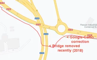
For anyone who is following this thread because they are interested in cellphone coverage and navigation apps for walking a Camino in 2025 and beyond: There is a thread drift about a section of the Camino Francés entering Leon. The section was temporarily changed in 2018.
In further explanation, this one section has been used by
@Camo to demonstrate his contention that Google maps are a more useful navigation aid than the other generalist or specialist smart phone navigation tools available to pilgrims. He has put substantial effort into this, which was originally linked through his page at
https://camoapps.com/.
The link to his camino work has been removed, thankfully, because there were walk sections that he proposed that would have been just plainly dangerous for pilgrims to walk, and would have directed pilgrims away from the safer routes that had been waymarked by the many local pilgrim associations who have an interest in creating as safe a path as is possible for us to walk. There were other places where his use of the navigation functions in Google Maps led to him suggesting paths that many of us who have actually walked those areas would have found ridiculous, and once again avoided the waymarking provided by local associations to keep pilgrims walking away from busier roads where possible.
His rant at #55 above is particularly odious, and several comments clearly misrepresent my earlier comments, but far worse, misrepresent the efforts of the creators of services and apps like Gronze,
Wise Pilgrim and CaminoDevil, just to name the ones that I specifically mentioned in an earlier post.
Are you saying All developers use this (one of many) CNIG file to make their apps? For sure mapy gets it right all the time and why would there be any responsibility on ME (working as a hobby) to assist (free of charge) those who (I assume) SELL their products here (or work on commissions I don't know and don't care).
This is a particular nasty slur about the motivations of the Gronze team and the developers of WisePilgrim and CaminoDevil, made worse by the admission that
@Camo is clearly deliberately careless about discovering how the development and presentation of these services and apps are funded. The Gronze website is freely available - there is no paywall, nor is there a paywall to the WisePilgrim online guide available on this forum. WisePilgrim, CaminoDevil and Gronze all freely distribute their smartphone apps, as do others. Some also provide a more capable version with greater functionality, but the free apps that I have checked all provide a minimum range of functions that would make them usable by pilgrims.
But ironically THAT is what I AM doing - as I explained above the dotted green lines (about 500 km of them) you see in Google products for Caminos, UK walking tracks etc etc ARE my way of HELPING. As I keep telling you they are free for anyone to use.
Getting Google to provide information that was already available in Open Street Maps and from the IGN is hardly rocket science. As for the information that Google has provided, it doesn't appear to be well integrated into the other geospatial data that it uses.
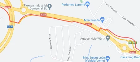
If I take the specific example of the bridge coming into Leon that you have been using, when I set up a route to connect the Camino path in OSMAnd+ on my Android phone and on my laptop on the OSM site, both recommend the 'new' section that you claim has been recently been added by Google. Why? Because OSM and IGN already knew about this change, and may well have for some years. It did not require special pleading to get that information made available. Yet Google did.
More, if I do use Google to propose a walking path between the same points, unlike OSM, which is able to recommend a path along the footpaths, Google suggest that one walk down the middle of Avenida de Madrid - hardly a safe proposal, and one I suggest no pilgrim will follow, but why can't Google identify the linkages between this 'new' section of their dataset and the footpaths and crosswalks that make walking safe?
BUT you are always trying to STOP me eg as in this case where you want to close the thread.
This is just bullshit. Short of an outright personal attack, which this almost is, I have never asked for this or any of your other threads to be closed. I would rather demonstrate that your work and use of Google mapping products in the ways you suggest is not yet mature enough to be considered a safe and reliable aid for pilgrims to use.
Now I am totally confused as you are saying I have some moral obligation to make my work public but then stop me doing so (#52 above) - and you are not even a mod
Yes you do. You have regularly asked for the assistance of fellow forum members who have been generous in making an effort and taking the time to assist you in this endeavour. Perhaps we had hoped that you might have produced something useful earlier than it appears you have, but that doesn't appear to have come to pass. You cannot expect to ask for our assistance and then not give anything back into the public domain.
Others might note that post #52 wasn't from me, nor did make any suggestion that this work not be made public. It was from an moderator, and merely suggested that you stay focussed on the topic, something you seem incapable of doing.
So I will just ignore you and reply to those above who have been so helpful with this discussion. But later as I think right now I need a drink and make a reality check (or maybe walk a Camino haha)
@Camo, I don't mind being ignored. It won't stop me alerting others that proposing unsafe routes, suggesting routes that ignore the efforts of local associations to waymark routes, and persistently promoting a mapping product that has consistently shown itself to be incapable of proposing sensible routing options does not make good sense. You have been regularly doing all these things.


