• Remove ads on the forum by becoming a donating member. More here.

Search 74,075 Camino Questions

Cell phone service and navigation apps

Camo

Active Member
Time of past OR future Camino
2024
Moderator note: This post and several following ones have been moved from another thread on a slightly different topic.

When I use the Gronze Maps app I only use it for navigation
But as you say it does not work without a data connection, so why not use google maps to start with and download the map data before you leave "home".
 
Last edited by a moderator:
€2,-/day will present your project to thousands of visitors each day. All interested in the Camino de Santiago.
But as you say it does not work without a data connection, so why not use google maps to start with and download the map data before you leave "home".
Because Google Maps does not show the Camino routes. I have a data connection while I'm on the Camino, so that's not a problem.
 
I have a data connection while I'm on the Camino
That's great news and totally different to my 2015 experience in UK and 2022 in Greece where it was sporadic at best and not just in The Sporades (joke in there😃) - so you are saying good old Spain is not backward at all and has mobile reception over the full length of all Caminos?
 
The 2024 Camino guides will be coming out little by little. Here is a collection of the ones that are out so far.
That's great news and totally different to my 2015 experience in UK and 2022 in Greece where it was sporadic at best and not just in The Sporades (joke in there😃) - so you are saying good old Spain is not backward at all and has mobile reception over the full length of all Caminos?
I get better cell reception in Spain (and France and Portugal) than I do in my hometown in Oregon!
 
so you are saying good old Spain is not backward at all and has mobile reception over the full length of all Caminos?
This is an odd jokey sort of way to ask if Spain has good mobile reception. Generally, yes, but no, there is not reception over the full length of all Caminos. I have encountered gaps on some of the less populated routes - various canyons have poor reception, and one area of the Lana has coverage from one provider but not others.

I get better cell reception in Spain (and France and Portugal) than I do in my hometown in Oregon!
I do too, in the suburbs of Vancouver, BC. There are some geographic features combined with a large body of unpopulated water, that mean the cell coverage is imperfect.
 
one area of the Lana has coverage from one provider but not others.
How many providers are there in Spain? - or at least in the North part. In Greece there were 3 (Vodaphone was main one) and as long as you bought your sim outside of Greece your phone would automatically switch to the best one for the area
 
Get a spanish phone number with Airalo. eSim, so no physical SIM card. Easy to use app to add more funds if needed.
But as you say it does not work without a data connection, so why not use google maps to start with and download the map data before you leave "home".
That is always an option for those car touring, but not generally, at least not yet, for those walking the camino, or any other pilgrimage route I have walked recently. I find it works best for the final kilometre or two when I am looking for accommodation or a restaurant, but not for walking route finding generally.
 
That is always an option for those car touring, but not generally, at least not yet, for those walking the camino
Yes it is always an option for car touring (or bike) as long as you simply want to go shortest path A to B but for example the Romanesque Track around Porto zig zags to take in all the Romanesque buildings etc so needs to be SET UP to include them before "send to phone".

Same with Caminos where there is a defined "yellow arrow track(s)" which must first be set up BUT the big advantage as you say is that instead of B etc being a town name it will be your reserved hostel name so no jumping around from app to app as it is all in Google Maps.

And you are also correct that Google may not have found and ACTIVATED some sections of the route, particularly side tracks in wooded areas that the AI can't see in the satellite imagery.

To that end I have been working with Google Content Partners for over a year to REPAIR all those bits and the great majority are now fixed, BUT seems Google has (understandably?) pulled the plug (sunset as they say) on that 2 weeks ago.

Google works in strange ways and this is hard to understand for Caminos where there is a cool billion euros spent on food/accom pa

So the answer is to simply set up your trip for the day (best on a laptop) and check against mappy etc it is correct and send to phone
 
This is an odd jokey sort of way to ask if Spain has good mobile reception.
That is an incredibly generous interpretation of a comment that many would take as a slur. Why anyone would make a comment suggesting that Spain or any other country is backward in a conversation about mobile coverage is just a little beyond me.
 
...and ship it to Santiago for storage. You pick it up once in Santiago. Service offered by Casa Ivar (we use DHL for transportation).
That is always an option for those car touring, but not generally, at least not yet, for those walking the camino, or any other pilgrimage route I have walked recently. I find it works best for the final kilometre or two when I am looking for accommodation or a restaurant, but not for walking route finding generally.
Mapy.cz is much better than Google Maps for following hiking and cycling trails, and regions can be downloaded to use offline.
 
Mapy.cz is much better than Google Maps for following hiking and cycling trails, and regions can be downloaded to use offline.
I use the Open Street Maps OSMAnd+ app for preference, but almost any decent mapping application using open source mapping would be preferable to having to rely on Google Maps. Even if one can download regions to have them available off-line, Google seems reluctant to include walking and cycling trail data to provide routing solutions that match the Camino paths. One only has to look at the efforts that @Camo made earlier in the year to realize how dangerous it could be to rely on Google Maps in places along the CF. I don't have the time to repeat the efforts he took at the time, and still get inaccurate and misleading results that don't follow the Camino route.
 
Last edited:
A selection of Camino Jewellery
Yes it is always an option for car touring (or bike) as long as you simply want to go shortest path A to B but for example the Romanesque Track around Porto zig zags to take in all the Romanesque buildings etc so needs to be SET UP to include them before "send to phone".

Same with Caminos where there is a defined "yellow arrow track(s)" which must first be set up BUT the big advantage as you say is that instead of B etc being a town name it will be your reserved hostel name so no jumping around from app to app as it is all in Google Maps.

And you are also correct that Google may not have found and ACTIVATED some sections of the route, particularly side tracks in wooded areas that the AI can't see in the satellite imagery.

To that end I have been working with Google Content Partners for over a year to REPAIR all those bits and the great majority are now fixed, BUT seems Google has (understandably?) pulled the plug (sunset as they say) on that 2 weeks ago.

Google works in strange ways and this is hard to understand for Caminos where there is a cool billion euros spent on food/accom pa

So the answer is to simply set up your trip for the day (best on a laptop) and check against mappy etc it is correct and send to phone
But why go to all the work to set it up on Google Maps when I can use Wise Pilgrim or Buen Camino or Camino Ninja to navigate without data and they have done all the set up for me?
 
Moderator note: This post and several following ones have been moved from another thread on a slightly different topic.


But as you say it does not work without a data connection, so why not use google maps to start with and download the map data before you leave "home".
As David says, there is a whole host of apps that will mark the camino route ten times better than Google Maps and most of them work offline. Not only that, they have really useful information about stuff like where to eat and spend the night. For anyone actually walking the camino, Google Maps is a waste of time.
 
That's great news and totally different to my 2015 experience in UK and 2022 in Greece where it was sporadic at best and not just in The Sporades (joke in there😃) - so you are saying good old Spain is not backward at all and has mobile reception over the full length of all Caminos?


This is the second time this week that someone here on the forum makes a lame joke about Spain being backwards and I find it utterly annoying when people think this.

No, Spain is not a backward country. Yes, of course there sometimes is less good or non existent mobile connection for a short while. Depending on the provider.
In general mobile reception is very good in Spain. Better than in the village ( in a valley ) where I live in Belgium and where I only have decent connection on the seventh step of the stairs or in the corrner of my backgarden.
 
Last edited:
€2,-/day will present your project to thousands of visitors each day. All interested in the Camino de Santiago.
As David says, there is a whole host of apps that will mark the camino route ten times better than Google Maps and most of them work offline. Not only that, they have really useful information about stuff like where to eat and spend the night. For anyone actually walking the camino, Google Maps is a waste of time.
I don't know I would go quite that far. It can be useful in a town, once you have reached your destination, to find your way to a local point of interest or to see where a nearby supermarket is. I just don't think I would use it for the actual Camino part.
 
This is an odd jokey sort of way to ask if Spain has good mobile reception. Generally, yes, but no, there is not reception over the full length of all Caminos. I have encountered gaps on some of the less populated routes - various canyons have poor reception, and one area of the Lana has coverage from one provider but not others.


I do too, in the suburbs of Vancouver, BC. There are some geographic features combined with a large body of unpopulated water, that mean the cell coverage is imperfect.
I was pleasantly surprised how good the reception was in a Spain, and also suffer from dropouts within 20 minutes walk from my house in North Vancouver..😀
 
As David says, there is a whole host of apps that will mark the camino route ten times better than Google Maps and most of them work offline. Not only that, they have really useful information about stuff like where to eat and spend the night. For anyone actually walking the camino, Google Maps is a waste of time.
I downloaded a gpx track, which I think David shared in a post on the forum somewhere. I used this in google maps through my whole Camino, alongside other apps..worked well for me..
 
A selection of Camino Jewellery
I downloaded a gpx track, which I think David shared in a post on the forum somewhere. I used this in google maps through my whole Camino,
Could you explain please how you used the gpx in Google Maps? Do you mean directly or did you use "directions" to "draw the route"? Normally a gpx etc imports into Google Earth or MyMaps

But with Caminos the big problem is always WHICH file to use as there is no central body like for UK walking trails that issues such a file that corresponds with the yellow arrows.

I started my Web-Apps the same way ie a file from this forum but was later told it was not THE file (where THE file does not seem to exist or you are threatened with legal action if you use it)

But I then found mappy and used it to correct the routes
 
I don't know I would go quite that far. It can be useful in a town, once you have reached your destination, to find your way to a local point of interest or to see where a nearby supermarket is. I just don't think I would use it for the actual Camino part.
Good point. I've used it myself to find the way out of town, it's amazing how many camino routes are elaborately marked once you are in open country but apparently don't exist in town. I haven't been walked through Vigo, but that is notorious.

Incidentally, so far as phone coverage is concerned, Spain puts my own country, Australia, to shame, but that is mainly the fault of the providers.
 
3rd Edition. Vital content training & pack guides avoid common mistakes, bed bugs etc
It can also be the fault of the sheer size of your country!
That is partly true, there´s not a lot of point providing mobile phone coverage to vast empty spaces where nobody lives, but even in urban areas, phone coverage in Australia is not great. I can only remember not having coverage once in Spain, on the Lana, and even then a friendly builder lent us his phone to call the ayuntamiento for the key to the albergue.
 
Could you explain please how you used the gpx in Google Maps? Do you mean directly or did you use "directions" to "draw the route"? Normally a gpx etc imports into Google Earth or MyMaps

But with Caminos the big problem is always WHICH file to use as there is no central body like for UK walking trails that issues such a file that corresponds with the yellow arrows.

I started my Web-Apps the same way ie a file from this forum but was later told it was not THE file (where THE file does not seem to exist or you are threatened with legal action if you use it)

But I then found mappy and used it to correct the routes
I used this https://www.google.com/maps/d/u/0/viewer?mid=1kY-ZPBKbZuHddt5e9JBCqHmAwG93kFVP&ll=40.10951631110862%2C-3.0533069999999984&z=7 as a starting point, and then edited it to take out the routes I didn't want. I added it to My Maps in Google. Appears to be created by CNIG which seems to be a legit organization...It was very accurate and useful t get through towns that didn't have great signage, including ironically, Santiago De Compostella :)
 
It can also be the fault of the sheer size of your country!
Or as Effie would say "How embarrassment" :) if only we had taller mountains!

But on the plus side we have the highest toilet in Oz right next to Mt Kosciusko (this spell checker likes it with an S as it used to be) and an environmentally friendly genius design so no toilet paper floating around the roof of Australia.
 
The 2024 Camino guides will be coming out little by little. Here is a collection of the ones that are out so far.
I used this https://www.google.com/maps/d/u/0/viewer?mid=1kY-ZPBKbZuHddt5e9JBCqHmAwG93kFVP&ll=40.10951631110862%2C-3.0533069999999984&z=7 as a starting point, and then edited it to take out the routes I didn't want. I added it to My Maps in Google. Appears to be created by CNIG which seems to be a legit organization...It was very accurate and useful t get through towns that didn't have great signage, including ironically, Santiago De Compostella :)
That link seems dead for me - could you please try again as I am very interested
 
A selection of Camino Jewellery
As a near-Luttite, I proudly confess to not using ANY apps to walk a Camino. Too often I pass people stopped in the middle of the road, hunched over their phones, trying to determine their next step, when 3 steps later, an obvious arrow presents itself. I prefer to look at a page in say a Brierley guide, or a page in Gronge the day before, and ON the day, merely walk . Look up. There are the arrows. Look up. There is everything you need to know and more. Look down, you miss it all. When did we become so unresourceful we needed an app to cross the street?
 
As a near-Luttite, I proudly confess to not using ANY apps to walk a Camino. Too often I pass people stopped in the middle of the road, hunched over their phones, trying to determine their next step, when 3 steps later, an obvious arrow presents itself. I prefer to look at a page in say a Brierley guide, or a page in Gronge the day before, and ON the day, merely walk . Look up. There are the arrows. Look up. There is everything you need to know and more. Look down, you miss it all. When did we become so unresourceful we needed an app to cross the street?
I don’t know why someone would feel proud not to use technology at our disposal. Personal choice of course but it is possible to use apps, and look up, and not miss things! There is no need to hunch over your phone, you can just glance!! Use of technology certainly doesn’t indicate that folks are unresourceful in my view.
 
The 2024 Camino guides will be coming out little by little. Here is a collection of the ones that are out so far.
I was pleasantly surprised how good the reception was in a Spain, and also suffer from dropouts within 20 minutes walk from my house in North Vancouver..😀
Why were you surprised? Did you expect less in Spain? It’s a pretty developed place!
 
Last edited:
I used this https://www.google.com/maps/d/u/0/viewer?mid=1kY-ZPBKbZuHddt5e9JBCqHmAwG93kFVP&ll=40.10951631110862%2C-3.0533069999999984&z=7 as a starting point, and then edited it to take out the routes I didn't want. I added it to My Maps in Google. Appears to be created by CNIG which seems to be a legit organization...It was very accurate and useful t get through towns that didn't have great signage, including ironically, Santiago De Compostella :)
That looks like the work of @David Tallan, presumably based on the CNIG kml files they provide. When I last looked, these files were provided to the CNIG by the Federación Española de Asociaciones de Amigos del Camino de Santiago.
 
As a near-Luttite
Rabbit hole alert: from the admittedly little I know of 19th century English social history, it might be conceded that the Luddites had a point. But on a more serious note, you are absolutely right. I remember walking the camino in 2015 and for the first time meeting a pilgrim who was following the route on a GPS. The general consensus was that here was a sadly deluded but harmless eccentric. What is the point in looking at a screen for information that has been beamed backwards and forwards across the ether via complex and expensive technologies when the very same information is there in front of you, along with lots of interesting stuff that comprises the new and exciting environment you are travelling through? It doesn't really make a lot of sense.

But there is another issue. The camino is not invulnerable, or rather the route is not invulnerable and there are constant local pressures to divert it it or block it. Local associations go to enormous effort to maintain the camino and one of the main ways of doing it is by physically marking the route Fr. Valiño style with those bright yellow arrows. It was noticeable when I walked a section of the Francés this year that a lot of the waymarks are fading. There could be a lot of reasons for this but it could be that the waymarks are regarded as redundant or local associations have lost interest and support. The waymarks may be a 20th century innovation but they have become an integral part of the camino and what it means. So I suggest we all use the waymarks as much as possible, be aware of where we are and keep our phones in our pockets - until we get lost.
 
Ideal sleeping bag liner whether we want to add a thermal plus to our bag, or if we want to use it alone to sleep in shelters or hostels. Thanks to its mummy shape, it adapts perfectly to our body.

€46,-
I don’t know why someone would feel proud not to use technology at our disposal. Personal choice of course but it is possible to use apps, and look up, and not miss things! There is no need to hunch over your phone, you can just glance!! Use of technology certainly doesn’t indicate that folks are unresourceful in my view.
If your phone was lost or stolen on day 2 of your Camino, would it in any way impact your ability to continue on your way? It would not for me because I don't rely on it. I feel that makes me more resourceful. Feel free to disagree.
 
So I suggest we all use the waymarks as much as possible, be aware of where we are and keep our phones in our pockets - until we get lost.
Good advice and I really have not used a GPS "hunch type" device for 11 years so don't know if one still needs to hunch but as I keep saying the genius of the Google Map satnav is you can leave it IN the pocket (volume turned off or on) and it says "turn right in 20 meters" etc even in the dark which was the big issue Hector had (he never said what he was using) as he left his auberge thingo in the dark going around in circles looking for yellow arrows (adding 50km to his trip).

Then once on the trail and hanging out for that cafe barista latte thingo you will have programmed a cafe into the satnav and it will keep updating you on the distance TO the Cafe.

Way to go in my book :)
 
...and ship it to Santiago for storage. You pick it up once in Santiago. Service offered by Casa Ivar (we use DHL for transportation).
That looks like the work of @David Tallan, presumably based on the CNIG kml files they provide. When I last looked, these files were provided to the CNIG by the Federación Española de Asociaciones de Amigos del Camino de Santiago.
Correct - I originally found a link from @David Tallan when I was preparing for my walk, but could not figure out how to link it to this thread. I subsequently modified a version of his link to only include the CF. I found it very useful on several occasions during my walk.
 
Why were you surprised? Did you expect less in Spain? It’s a pretty developed place!
Nothing to do with thinking Spain would be undeveloped, as I have been many times before.

I was pleasantly surprised for two reasons.
  1. I am used to having dropouts so close to my own home, which is also a pretty developed place..not a case of expecting less in Spain, more like expecting more in my own neck of the woods :)
  2. It was first time using my Canadian phone plan in Spain. The plan covers all countries in Europe, without the need for additional SIM, and also no roaming charges. I was therefore happy that it worked flawlessly
 
If your phone was lost or stolen on day 2 of your Camino, would it in any way impact your ability to continue on your way? It would not for me because I don't rely on it. I feel that makes me more resourceful. Feel free to disagree.
No it wouldn’t… it’s just a town to town, village to village walk after all, though if my phone was stolen I guess it would mean I would stop anyway until I was sure that my online security was under minimal threat. I won’t pretend I can use proper navigation equipment though. That’s why I do Camino, due to its logistical ease.
 
The 2024 Camino guides will be coming out little by little. Here is a collection of the ones that are out so far.
A
Nothing to do with thinking Spain would be undeveloped, as I have been many times before.

I was pleasantly surprised for two reasons.
  1. I am used to having dropouts so close to my own home, which is also a pretty developed place..not a case of expecting less in Spain, more like expecting more in my own neck of the woods :)
  2. It was first time using my Canadian phone plan in Spain. The plan covers all countries in Europe, without the need for additional SIM, and also no roaming charges. I was therefore happy that it worked flawlessly
Ah ok thank you! Just interested in what folks expect when they come to Spain/Europe etc. Some people (not you) seem quite surprised that things work pretty seamlessly and are developed around finances, tech, transportation, even food.
 
As a near-Luttite, I proudly confess to not using ANY apps to walk a Camino. Too often I pass people stopped in the middle of the road, hunched over their phones, trying to determine their next step, when 3 steps later, an obvious arrow presents itself.
Nowadays, says the internet (I am making use of modern technologies), the term "Luddite" often is used to describe someone who is opposed or resistant to new technologies.

This puzzles me: How can one be a near-Luddite (or is near-Luttite something different?) and making use of this online forum and its online resources? And how does one know what people, being hunched over their phones or not, are looking for? If it were me, I'd probably be looking for the quickest and shortest way to my accommodation after having arrived in town. No yellow arrow will be pointing to it. And asking Apple Maps (in my case but it's similar to Google Maps) to lead me to my well deserved bed beats asking another foreigner who will only reply: "I don't know either and I won't get my mobile phone to tell you". 😂

Apologies for the thread drift but I am not sure what this thread is for anyway. Is it about "Don't use cell phone services and navigation apps"??? :cool:
 
Last edited:
It can also be the fault of the sheer size of your country!
I too find the mobile coverage in Spain to be excellent. I have stood on top of many a remote hill/mountain in Spain and had full 4g coverage. In UK where I live (South East England in a very populated area) there are many places where there is no mobile signal or only 3g. Spain is significantly larger than UK and less densely populated.
 
Ideal sleeping bag liner whether we want to add a thermal plus to our bag, or if we want to use it alone to sleep in shelters or hostels. Thanks to its mummy shape, it adapts perfectly to our body.

€46,-
As a near-Luttite, I proudly confess to not using ANY apps to walk a Camino. Too often I pass people stopped in the middle of the road, hunched over their phones, trying to determine their next step, when 3 steps later, an obvious arrow presents itself. I prefer to look at a page in say a Brierley guide, or a page in Gronge the day before, and ON the day, merely walk . Look up. There are the arrows. Look up. There is everything you need to know and more. Look down, you miss it all. When did we become so unresourceful we needed an app to cross the street?
If you use wikiloc then there is no need to look at anything as you can set it to notify you if you move off of the path.
 
I know that this thread was created by moderators who - thankfully! - removed off-topic comments from a thread about the Gronze Maps app.

People who lack experience of using map apps and navigation apps because they either have never walked on a Camino in Spain or don't use such apps for whatever personal reasons and personal convictions while walking on a Camino in Spain appear to have preconceived ideas about how and why others use such apps, and their lack of hands-on practical experience prevents them from making meaningful and helpful comments on why a particular app may be more useful to a particular pilgrim than another one.

To think that those who make use of map apps and navigation apps could not find their way to Santiago without them is absurd. These apps have numerous purposes and are used in different ways. And that's good the way it is.
 
Last edited:
€2,-/day will present your project to thousands of visitors each day. All interested in the Camino de Santiago.
I don't want to derail this thread, but can you just tell me what plan you use?
Freedom Roam Beyond..they no longer offer it as a stand-alone plan, but it is bundled in with a couple of their current plans. It has worked flawlessly for me in several European countries..
 
I feel that makes me more resourceful.
On the much lesser-walked Caminos a distinctively higher level of resourcefulness is required without an App than the CF for example. Traditionally paper maps would be carried of course but I appreciate the progress of transistor-based technology where track markings may be scarce.
 
Ideal sleeping bag liner whether we want to add a thermal plus to our bag, or if we want to use it alone to sleep in shelters or hostels. Thanks to its mummy shape, it adapts perfectly to our body.

€46,-
Yup that works fine and is the same one I used initially and then corrected/refined it - will explain later
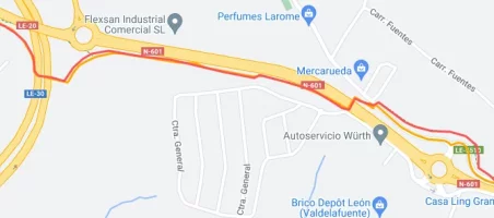
OOOps, sorry my file was from a different mod here and is slightly different. To get the ball rolling I like to go to the path into Leon where 2018 roadworks SHOULD have prompted changes to apps (as for mappy as one example) - here yours is red mine is orange but both still take you over the bridge (in thin air) that was removed in 2018.

track4.webp

More to come!
 
Last edited:
More to come!
Now back to you two with a question. I only work on laptop and mobile is purely for grocery list so I don't even know if MyMaps is on smartphones or not so can you please tell me if when you say this works for you are you using this directly as it (faults and all) to actually navigate? or do you too export it to GoogleEarth or GoogleMaps to use it there for "other" purposes.

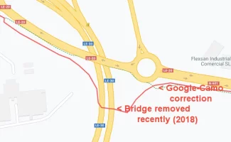
In any case lets start with the veracity of the file you (and I) are using and here is the post 2018 pedestrian bridge Google corrected for me. So the green dotted line is now in the BACKGROUND data (same as yellow roads) for all to use and not part of our lines. I think this is referred to in this forum as geospatial data??

track2.webp
 
Last edited:
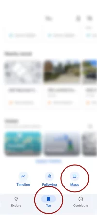
I used as is, generally it was easy to follow the signs, and other pilgrims, but this came in handy in the cities, especially earlier in the mornings when not so many people were around…to use it I opened google maps, select You and then Maps, and this will bring up your MyMaps that you have saved.

IMG_0463.webp
 
3rd Edition. Vital content training & pack guides avoid common mistakes, bed bugs etc
Now back to you two with a question. I only work on laptop and mobile is purely for grocery list so I don't even know if MyMaps is on smartphones or not so can you please tell me if when you say this works for you are you using this directly as it (faults and all) to actually navigate? or do you too export it to GoogleEarth or GoogleMaps to use it there for "other" purposes.

In any case lets start with the veracity of the file you (and I) are using and here is the post 2018 pedestrian bridge Google corrected for me. So the green dotted line is now in the BACKGROUND data (same as yellow roads) for all to use and not part of our lines. I think this is referred to in this forum as geospatial data??

View attachment 181068
This needs to be on a separate thread. It is related to a specific link to a specific place. Please keep the discussion on track.
 
You and then Maps, and this will bring up your MyMaps that you have saved.
WOW that is just so clever and solves all the problems identified in these many threads. Oh McGoogle you've done it again:)

And even better if YOUR track is the FIXED version as I will explain later (but not at this location:rolleyes:)

Thank you very much indeed
 
2018 roadworks SHOULD have prompted changes to apps
If you have identified that there are these issues with the CNIG provided data that have subsequently been embedded into apps by their developers, wouldn't it be more effective to tell those developers? I know several here, @Joan Fiol (Gronze.com), @wisepilgrim and @geraldkelly from Gronze, WisePilgrim and CaminoDevil who want to keep their apps up to date. You could help.
 
A selection of Camino Jewellery
these issues with the CNIG provided data that have subsequently been embedded into apps by their developers
Are you saying All developers use this (one of many) CNIG file to make their apps? For sure mapy gets it right all the time and why would there be any responsibility on ME (working as a hobby) to assist (free of charge) those who (I assume) SELL their products here (or work on commissions I don't know and don't care).

But ironically THAT is what I AM doing - as I explained above the dotted green lines (about 500 km of them) you see in Google products for Caminos, UK walking tracks etc etc ARE my way of HELPING. As I keep telling you they are free for anyone to use.

BUT you are always trying to STOP me eg as in this case where you want to close the thread.

Now I am totally confused as you are saying I have some moral obligation to make my work public but then stop me doing so (#52 above) - and you are not even a mod

So I will just ignore you and reply to those above who have been so helpful with this discussion. But later as I think right now I need a drink and make a reality check (or maybe walk a Camino haha)
 
For anyone who is following this thread because they are interested in cellphone coverage and navigation apps for walking a Camino in 2025 and beyond: There is a thread drift about a section of the Camino Francés entering Leon. The section was temporarily changed in 2018.

In 2018, there were major roadworks concerning the roads in this area. The Camino Association of Leon, in cooperation with the authorities, worked out and marked a 2 km detour. It was in place from around April 2018 until at least December 2018 (perhaps later, I did not bother to check). We had a number of threads about it because many of those who walked at the time did not easily forget it, including yours truly. There was a part that was rather steep and slippery and muddy, especially when it rained. My left shoe got stuck in the mud there 😂. Ah, the memories.

But that was now six years ago. The roadworks were eventually finished, the Camino Francés trail got rerouted again and adapted to the new traffic situation in this area and it is all just memories and of no concern to those who are walking right now or will be walking next year ...
 
3rd Edition. Vital content training & pack guides avoid common mistakes, bed bugs etc
of no concern to those who are walking right now or will be walking next year ...
The section of the Camino Francés from Arcahueja into Leon is pretty straight forward nowadays and you don't even need a navigation app for it. I checked Gronze.com which has not only an online map but also a description in words, and an additional app that complements their excellent offer for pilgrims:

We cross the N-601 over a footbridge installed in 2010 [this is the well-known "blue" pedestrian bridge]; [this crossing] used to be a real danger for walking pilgrims. Shortly afterwards we cross the LE-30 ring road over another footbridge [this is the footbridge that was constructed during the roadworks in 2018]. We enter the Puente Castro neighbourhood via Avenida de Madrid; halfway along this avenue we turn left into Calle Victoriano Martínez.
No worries! And Buen Camino!
 
Shortly afterwards we cross the LE-30 ring road over another footbridge [this is the footbridge that was constructed during the roadworks in 2018].
Yes indeed so gronze is one app that does not say we NO LONGER (after 2018) cross this (removed) footbridge.

So we have 2 files (recommended by this forum) and one app that have yet to be updated 6 years later

So what is the news on the remaining apps please Kathor?
 
So what is the news on the remaining apps please
Huh? I did not notice any posts from pilgrims having trouble finding their way into Leon this year or last year. Did you? Is there an issue that needs discussing and relevant information to share for current and future pilgrims to assist them with finding their way there? Sorry, I don't see it.
 
The one from Galicia (the round) and the one from Castilla & Leon. Individually numbered and made by the same people that make the ones you see on your walk.
For anyone who is following this thread because they are interested in cellphone coverage and navigation apps for walking a Camino in 2025 and beyond: There is a thread drift about a section of the Camino Francés entering Leon. The section was temporarily changed in 2018.
In further explanation, this one section has been used by @Camo to demonstrate his contention that Google maps are a more useful navigation aid than the other generalist or specialist smart phone navigation tools available to pilgrims. He has put substantial effort into this, which was originally linked through his page at https://camoapps.com/.

The link to his camino work has been removed, thankfully, because there were walk sections that he proposed that would have been just plainly dangerous for pilgrims to walk, and would have directed pilgrims away from the safer routes that had been waymarked by the many local pilgrim associations who have an interest in creating as safe a path as is possible for us to walk. There were other places where his use of the navigation functions in Google Maps led to him suggesting paths that many of us who have actually walked those areas would have found ridiculous, and once again avoided the waymarking provided by local associations to keep pilgrims walking away from busier roads where possible.

His rant at #55 above is particularly odious, and several comments clearly misrepresent my earlier comments, but far worse, misrepresent the efforts of the creators of services and apps like Gronze, Wise Pilgrim and CaminoDevil, just to name the ones that I specifically mentioned in an earlier post.

Are you saying All developers use this (one of many) CNIG file to make their apps? For sure mapy gets it right all the time and why would there be any responsibility on ME (working as a hobby) to assist (free of charge) those who (I assume) SELL their products here (or work on commissions I don't know and don't care).
This is a particular nasty slur about the motivations of the Gronze team and the developers of WisePilgrim and CaminoDevil, made worse by the admission that @Camo is clearly deliberately careless about discovering how the development and presentation of these services and apps are funded. The Gronze website is freely available - there is no paywall, nor is there a paywall to the WisePilgrim online guide available on this forum. WisePilgrim, CaminoDevil and Gronze all freely distribute their smartphone apps, as do others. Some also provide a more capable version with greater functionality, but the free apps that I have checked all provide a minimum range of functions that would make them usable by pilgrims.
But ironically THAT is what I AM doing - as I explained above the dotted green lines (about 500 km of them) you see in Google products for Caminos, UK walking tracks etc etc ARE my way of HELPING. As I keep telling you they are free for anyone to use.
Getting Google to provide information that was already available in Open Street Maps and from the IGN is hardly rocket science. As for the information that Google has provided, it doesn't appear to be well integrated into the other geospatial data that it uses.

If I take the specific example of the bridge coming into Leon that you have been using, when I set up a route to connect the Camino path in OSMAnd+ on my Android phone and on my laptop on the OSM site, both recommend the 'new' section that you claim has been recently been added by Google. Why? Because OSM and IGN already knew about this change, and may well have for some years. It did not require special pleading to get that information made available. Yet Google did.

More, if I do use Google to propose a walking path between the same points, unlike OSM, which is able to recommend a path along the footpaths, Google suggest that one walk down the middle of Avenida de Madrid - hardly a safe proposal, and one I suggest no pilgrim will follow, but why can't Google identify the linkages between this 'new' section of their dataset and the footpaths and crosswalks that make walking safe?
BUT you are always trying to STOP me eg as in this case where you want to close the thread.
This is just bullshit. Short of an outright personal attack, which this almost is, I have never asked for this or any of your other threads to be closed. I would rather demonstrate that your work and use of Google mapping products in the ways you suggest is not yet mature enough to be considered a safe and reliable aid for pilgrims to use.
Now I am totally confused as you are saying I have some moral obligation to make my work public but then stop me doing so (#52 above) - and you are not even a mod
Yes you do. You have regularly asked for the assistance of fellow forum members who have been generous in making an effort and taking the time to assist you in this endeavour. Perhaps we had hoped that you might have produced something useful earlier than it appears you have, but that doesn't appear to have come to pass. You cannot expect to ask for our assistance and then not give anything back into the public domain.

Others might note that post #52 wasn't from me, nor did make any suggestion that this work not be made public. It was from an moderator, and merely suggested that you stay focussed on the topic, something you seem incapable of doing.
So I will just ignore you and reply to those above who have been so helpful with this discussion. But later as I think right now I need a drink and make a reality check (or maybe walk a Camino haha)
@Camo, I don't mind being ignored. It won't stop me alerting others that proposing unsafe routes, suggesting routes that ignore the efforts of local associations to waymark routes, and persistently promoting a mapping product that has consistently shown itself to be incapable of proposing sensible routing options does not make good sense. You have been regularly doing all these things.
 
Last edited:
A selection of Camino Jewellery
I used as is, generally it was easy to follow the signs, and other pilgrims, but this came in handy in the cities, especially earlier in the mornings when not so many people were around…to use it I opened google maps, select You and then Maps, and this will bring up your MyMaps that you have saved.
OK thanks again and IF ALLOWED I will calmly continue my explanation for you and just hope the mods etc don't interrupt again BEFORE I finish.

and to at doug who said

@Camo, I don't mind being ignored. It won't stop me alerting others

I am not putting you on "ignore" but simply trying to interpret your "instructions" and to that end I will now select AT RANDOM another section of the Camino Frances (or any other Camino you may wish to nominate) to explain to at stewinyvr and anyone interested what I am TRYING to explain (for the good of all).

So the new example is "DESTINATION CLASSIFIED" and I have removed any identification (no idea why you are asking but I will try to keep you happy). OR please nominate a place yourself for my explanation

After that I would LOVE to have you judge me but PLEASE let me finish my reply to at stewinyvr. At law the RIGHT TO REPLY is fundamental in a democratic country.

Is that OK?
 
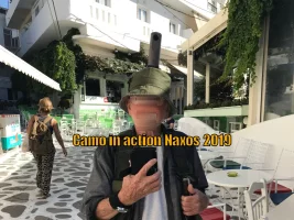
OMG how did you arrive at that 6 year old site. It is purely a placemaker directory to house the 300 websites (with 103 Gb of content) on the public_html directory at my Host

I have updated it (with a new selfie) and if the old file is still in your cache here it ismaintabs.webp
I have blotted out my face as I am nowhere near as handsome as Ivar below - bur for the record have 11 million views on Street View against his half million Compostelas (just joking so please don't jump on me again mods)
🤨

It was taken by a friendly German tourist who jumped out of Saris Restaurant when he saw my pano camera on hat and bought me lunch as we chatted. People in Greece are just Soooo friendly.

How I wish I could go back but my heart specialist has stopped me flying.
 
Last edited:
OMG how did you arrive at that 6 year old site. It is purely a placemaker directory to house the 300 websites (with 103 Gb of content) on the public_html directory at my Host
Why do you try to ridicule the earlier reference to https://camoapps.com/? It is the address of the website that you had posted several times in the past. And it is the address where your apps are, for example this one: https://camoapps.com/caminodublin/ . Your comment on the webpage with this url - accessible at the time of writing this post - says that this is a Service of camosdigitalnomadservices.com and it provides a Virtual Tour (or a Guide to WALK the Camino route). In this case the Camino is an Irish "warm-up" Camino and so on and so on.

I read again through this thread to see what makes sense with reference to the thread topic and what does not. What might be helpful for current and future pilgrims and what is not. So it's about the usability and usefulness of Google Maps and whether or not kml files or gpx files or whatever format files, when imported into Google Maps, are up to date or not or update themselves somehow. Fair enough. Also fair enough: It is my understanding that even when such files are made available for free to the general public they are meant for private individual use - unless a licence was granted for commercial or semi-commercial offers. Do I see this correctly so far? You hint at not being allowed to publish this and that - did you run foul of copyright laws?
 
...and ship it to Santiago for storage. You pick it up once in Santiago. Service offered by Casa Ivar (we use DHL for transportation).
@Camo, I am only just catching up with your posts. Here are two comments you have put out in public that need to be addressed:
At law the RIGHT TO REPLY is fundamental in a democratic country.
No it isn't. There are many legal rights, but according to wikipedia, the only country with a legally mandated Right to Reply is Brazil. It might be a privilege granted by a publication such as a newspaper, but it doesn't seem to exist as a right in the way you suggest in any other country, democratic or otherwise.
OMG how did you arrive at that 6 year old site.
You gave it out on this forum earlier in the year. If you are so worried about people using old sites, I can only wonder what you are doing here, on a forum that has supported pilgrims for just a little more than 20 years.
 
I can only wonder what you are doing here, on a forum that has supported pilgrims for just a little more than 20 years.
Well call me old fashioned if you like but I still believe (and support) the catchcry we small number of pioneers used on that first day of the Internet 30 years ago which was "The Information Superhighway".

For many years I scraped a living from services, mainly legal advocacy services (as far as The High Court) for victims of the evil Family Law Industry and CSA conglomerate and in 2005 I am proud to say the Howard govt was forced to make a monumental Amendment to the CSAct (Cth) including a totally revised (fair) formula that saved men about a billion a year and reduced the suicide rate of such victims dramatically.

My greatest joy was when the Chief Justice of the FCA read one of my submissions about an abusive mother and her pedophile partner and instantly changed the custody to the father and said to my LIP "whoever wrote your Submissions at Law is a breath of fresh air, why can't you lawyers do something like this?"

The LIP and I linked arms and skipped all the way out of the court building pursued by the gaggle of lawyers singing "why can't you lawyers do something like this" I love the smell of victory in the court :)

Once I reached pension age I wrote my book on Family Law and "retired" to more pleasurable things one of which was (and still is) the touring industry and while I have no money I don't need any money so that has totally removed the commercial aspect from my activities. It's a far better life simply CREATING and if my Web-Apps give help and joy to others that makes me more happy.
 
Last edited:
...and ship it to Santiago for storage. You pick it up once in Santiago. Service offered by Casa Ivar (we use DHL for transportation).
Oh how I regret now that I posted and provided an opportunity for a reply…. 🥴
Yes as in the other thread about "it" I repeat that unlike the Perambulating Griffin chap I REMAINED lapsed as a Catholic (for reasons which are best not mentioned here) but I am a great fan of Jesus the man and try to follow his teachings as much as possible.😇

So this is a case of simply "turn the other cheek" and it worked perfectly again. THANK YOU

And I think it is only fair to warn you that if you(s) open any more doors I will be forced to tell all about my own "Compostela" ie the UTC Carrier Presidents Award in 1985 (a 2 week world trip) of which I am totally proud 40 years later.
 
Last edited:
Try this one - this is the actual map I used ( Camino Frances ) - I just edited the link, so if you already tried, please try again.. :)
OK let's continue

The map below (in My Maps) is my new (secret) location to demonstrate your next option for the use of the gpx track you are using.
track5.webp
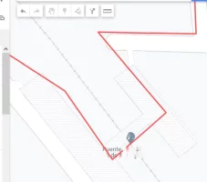
As you will see these files you and I are using are very low res (probably a record every 50 meters or so) and NOT "computer generated". Think of a Battle of the Bulge German tank trying to navigate the Monte Carlo F1 Circuit - it would simply get stuck on the hairpin corners. But as it is said here that is "good enough" to get you (in this case) over the railway line and on with your Camino. But totally useless for any derived function such as measuring distance.

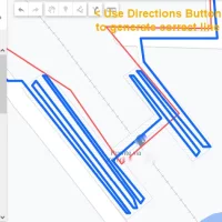
But you COULD have a perfect line simply by selecting the Directions button after which you get the BLUE line below
track6.webp
As seen on the road coming in at the top it perfectly runs down the middle of the roads and around the corners while the red line just takes a big zig-zag. Once on the overpass it perfectly negotiates the 9 swichbacks. The result is the true distance just for this one section is about 1 km LONGER than that derived from the red line.

So when you export this blue line to Google Maps you have a very accurate path to follow AS IS, but better still you can can instantly convert it to a Sat Nav and then customise it to bend to your chosen eat/sleep places.

Please try it on a typical day walk and let me know.

I realise that even in a disguised format the above may be "offensive" to some people so I will also give another example and kill 2 birds.

Trecile has suggested (fairly correctly) I do this "for the joy" BUT I am not obsessed with getting it 100% right in all cases so if there is too much agro I just throw in the RED sign which says NO Sat Nav here.

This is the in progress walk1 for Tall Ships and if you hit the blue Sat Nav button it displays the Sat Nav and as UK routes usually involve private fields Google is often not willing to activate links, SO here we get the RED button (but Public Transport is OK)
Trackcard
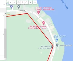
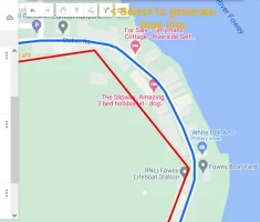
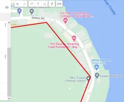
The image below is the gpx file from UK Pilgrims and is very similar to Spanish one above with a record every 50 meters or so. It is in Fowey (walk 3 yet to made) and this is a section where the links are ALREADY active,tracking5.webp
so a click on the Directions button gives a blue line which exactly follows the road so can be used where precision is important. THANK YOUtracking6.webp
I need a drink 🍺
 

Attachments

  • tracking5.webp
    tracking5.webp
    20.9 KB · Views: 3
Last edited:
Ideal sleeping bag liner whether we want to add a thermal plus to our bag, or if we want to use it alone to sleep in shelters or hostels. Thanks to its mummy shape, it adapts perfectly to our body.

€46,-
It is like a crash site. You drive past it and you know that you must not look or react in any way or form but you do ...

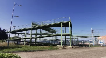
Folks, he is talking about how to get over the metal pedestrian bridge just before Astorga. Known to Camino pilgrims as the Green Monster.

How to get over it, how you got over it, how to record the deed, and how you recorded your deed.

I'll start: I walked over it without using a navigation app. At the time I did not record my walking on my iPhone. I did so this year from Le Puy and I used the inbuilt app on my Apple Watch which synchronises with my RunGap on my iPhone. I also used Pocket Earth now and then to check something. It's all I need and want although I have an array of other map apps and navigation apps that I load, use and remove as I see fit. I do have a visual record of my earlier 1800+ km walk to Santiago. I am a section walker with a good memory. After each section, at home on the Mac, I drew the corresponding line in magenta into Google Earth Pro and saved it in GE. I sometimes make a screenshot of the whole thing and print it and show it to people. They fake polite interest. 😇

Note the huge sign in blue and yellow with arrow and shell on the right side: You really can't miss it. :)

Railway bridge.webp
 
Last edited:
Once on the overpass it perfectly negotiates the 9 swichbacks. The result is the true distance just for this one section is about 1 km LONGER than that derived from the red line.
That is fascinating! Google Maps seems to have added two additional 'switchbacks' to achieve this. There are four longer ramps of about 27m and a shorter ramp on the NE side, and three longer ramps of about 37m and a shorter one on the SW side. The span over the railway is about 18 m. The length of the bridge is about 280 m, which certainly is not going to add a kilometre. So unless there is some other part of this that @Camo is not showing us, suggesting that Google Maps has perfectly negotiated this is just more nonsense.

I ask why this in any way important to even the most finicky pilgrim. If anyone doesn't know it already, there are going to be many things along the way each day that will make the actual distances one walks different from the figures provided in guides. No-one is going to even try and walk over a bridge that is no longer there just because an old route has been shown in an app, nor will anyone in Fovey think of walking through the buildings along Station Road as if they were ghosts that could pass through solid objects. It makes no sense to be so fixated, particularly when the tool being used, Google Maps, has failed to demonstrate that it can actually produce a workable navigation solution for walking pilgrims.
 
Last edited:
Thanks for your replies both of you - very interesting but with respect we need to STAY on track (pun intended)

My own input was in answer to stewinyvr who asserted the use of a file by some CNIG ?? which he says was (for HIS use) "very accurate" in MyMaps

"I added it to My Maps in Google. Appears to be created by CNIG which seems to be a legit organization...It was very accurate and useful t get through towns that didn't have great signage, including ironically, Santiago De Compostella"

He then went on to say he IMPORTED it to Google Maps and USED it with good results. He showed the button to press on a mobile to do that (#51 above) and I can now report back to him (with thanks) there IS a similar button (called Saved) on laptop (Windows) version of Google Maps THANK YOU

I thanked him (for myself but moreso on behalf of others) and went on to show him how to convert that to an even MORE accurate line IF a person (such as me) NEEDED/WANTED to be more precise.

Seems to me from your replies eg correcting the switchbacks that you AGREE that files (good and better) CAN be imported into Google Maps.

End of discussion on that point but more to come. THANK YOU
 
Last edited:
The 2024 Camino guides will be coming out little by little. Here is a collection of the ones that are out so far.
Seems to me from your replies eg correcting the switchbacks that you AGREE that files (good and better) CAN be imported into Google Maps.
@Camo, you should have told us that this is what you were interested in. If you had, I could have told you that if importing tracks is a function provided by the Google Maps software, my opinion on this is completely irrelevant to its existence. Unless, of course, you think I am some sort of wizard who can make things appear or disappear just by having an opinion, and you were worried that I might think it didn't exist, when it would instantly vanish on my thinking it didn't :)
 
Last edited:
I sometimes make a screenshot of the whole thing and print it and show it to people. They fake polite interest. 😇
Yes it can be most frustrating at first when you do a lot of work and "people" are sort of ho-hum about it. But that does not stop you doing it again and again and you finally realise that it does not matter what others think because the bottom line is you really did it for YOURSELF so a bit like trying to explain to others about the "it" you get/got from walking a Camino.

The difference with me is I do it as a Web-App and usually FTP it to the Web, but never ever check to see if anyone looked. Horses for courses again
🐴
 
That is fascinating! Google Maps seems to have added two additional 'switchbacks' to achieve this.
Nice one -absolutely correct and MY mea culpa (which Google followed). This is the opposite of the Big BLUE Monster above where I asked them to activate the footbridge that was no longer there and they came back and corrected me (and the file we were all using).

Here is a reply from Google 12 days ago amid the sunrise/sunset confusion of Content Partners

"Thank you so much for sharing your knowledge about the places around you. Unfortunately, your dataset cannot be processed through the Google Maps Content Partners pipeline, as this channel is primarily dedicated to organizations.

However, we think you would be a great fit as a Local Guide providing User Generated Content (UGC). By sharing reviews, photos, and knowledge on Google Maps, Local Guides influence how millions of people navigate and explore the world. Everyone can contribute. Click here to learn more: https://maps.google.com/localguides/ "


5 days later I was RE-approved after they understood this Camino thing was turning over a billion Euros a year. o_O

HOWEVER if I would be a great fit YOU would be a far BETTER fit as you have WALKED the whole path while I was trying to sort out the Green Monster from Street View.

BUT if you would rather not join and FIX these switchbacks I would be pleased to try myself under their new rules so please say.
 
Last edited:
A selection of Camino Jewellery
Nice one -absolutely correct and MY mea culpa (which Google followed). This is the opposite of the Big BLUE Monster above where I asked them to activate the footbridge that was no longer there and they came back and corrected me (and the file we were all using).

Here is a reply from Google 12 days ago amid the sunrise/sunset confusion of Content Partners

"Thank you so much for sharing your knowledge about the places around you. Unfortunately, your dataset cannot be processed through the Google Maps Content Partners pipeline, as this channel is primarily dedicated to organizations.

However, we think you would be a great fit as a Local Guide providing User Generated Content (UGC). By sharing reviews, photos, and knowledge on Google Maps, Local Guides influence how millions of people navigate and explore the world. Everyone can contribute. Click here to learn more: https://maps.google.com/localguides/ "


5 days later I was RE-approved after they understood this Camino thing was turning over a billion Euros a year. o_O

HOWEVER if I would be a great fit YOU would be a far BETTER fit as you have WALKED the whole path while I was trying to sort out the Green Monster from Street View.

BUT if you would rather not join and FIX these switchbacks I would be pleased to try myself under their new rules so please say.
The message you got from Google seems very nice if that is your thing, but the cynic in me thinks it sounds too much like recruiting advertising. My previous attempts at addressing the short-comings evident in Google Maps some years ago didn't achieve any change. These days I would much rather help the camino app developers - whenever I have let them know about an issue with their apps, a fix has been distributed within a couple of days, sometimes a couple of hours. And if I were going to support one of the organisations providing the underlying geo-spatial information, it would be OpenStreetMap, a community driven, open data initiative. But you've clearly drunk the kool-aid over at Google, just don't expect me to join you there anytime soon.
 
But you've clearly drunk the kool-aid over at Google, just don't expect me to join you there anytime soon.
That's cool - best to stick with what one does best (Peter Principle applied) but in any case I had second thoughts and decided this particular change under the newly sunrised "rules" at Google might be a bit hairy for a newbie so I have tried it myself (and it WAS yet another new tool) and submitted it yesterday and yet to hear back.

But thanks for the courtesy of a reply :)
 

❓How to ask a question

How to post a new question on the Camino Forum.

Most read last week in this forum

Let me start off by saying that I have done 10 Caminos. This is not to brag but to say that I should have known better. Before my last one, my grandkids convinced me that I should document the...
I'm sure a lot of us pour over our Camino photos from time to time as they bring back such wonderful memories. Not just of that great view or amazing meal, but some may have a much greater meaning...
I've always wondered about the security bars you frequently see on the windows of homes in Spain. The obvious purpose is security, but they are so ubiquitous, including on the windows of houses in...
Among the many, many things I was ignorant of is the Jubilee Camino. Coming home from London yesterday, while scanning the departure boards at the station, I had a chance meeting with a fellow...
I got back from my first Camino earlier this year in September. I loved it, found a lot of joy and strength from the experience. But I didn't really think that I would do it again. It was a...
There seems to be a sense that the number of pilgrims walking in Spain will continue to increase every year, putting more and more pressure on the infrastructure and impacting on all the things...

Featured threads

❓How to ask a question

How to post a new question on the Camino Forum.

Forum Rules

Forum Rules

Camino Updates on YouTube

Camino Conversations

Most downloaded Resources

Featured threads

This site is run by Ivar at

in Santiago de Compostela.
This site participates in the Amazon Affiliate program, designed to provide a means for Ivar to earn fees by linking to Amazon
Official Camino Passport (Credential) | 2024 Camino Guides
Back
Top