Search 74,075 Camino Questions

Alert WARNING ⛔️: Las Palancas on the Camino del Norte

Topics realted to Hazards on the camino de Santiago

El Cascayal

Veteran Member
Time of past OR future Camino
23:Valença Var Espiritual Apr; Norte Cudillero Oct
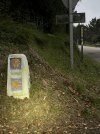
On the 6th of October of this year I walked the official Camino from Soto de Luiña on the Norte. I had been looking forward for months to walking this route por Palancas. I took a left hand turn at the markers toward the mountain. Most Peregrinos take the coastal route forward on the road.

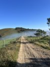
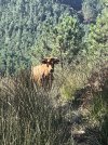
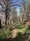
WARNING ⛔️: At this point in time the route is impassable. Grass is knee high and tangles your feet even with poles. In places the grass reached my hat. The thorns reached my waist. The descent was steep and difficult. There were good stretches on the logging road. A big cow trekked me & stood her ground.

Once you cross AS-268 and enter the woods, the trail which parallels the road becomes much worse. There is a long-standing thick fallen tree that I could not climb over and had to slide down a ravine towards the right holding on to tree branches and then scrambling back up. Pity that TSA confiscated my machete and I had not signed up for an episode of National Geographic. For the first time ever I ran out of water on a Camino despite carrying 2.5 L, this friendly neighbor and her cat so kindly offered me water.

The worst part of it was the vandalism of the mojones, recently placed and at great cost, which were thrown on the ground, some dragged and hidden, some purposely placed in the wrong way. So demoralizing to witness. Thankful for GPS Buen Camino & Wise Pilgrim.
 

Attachments

  • IMG_3910.jpeg
    IMG_3910.jpeg
    1.6 MB · Views: 7,435
  • IMG_3922.jpeg
    IMG_3922.jpeg
    2.8 MB · Views: 361
  • IMG_3947.jpeg
    IMG_3947.jpeg
    2 MB · Views: 339
  • IMG_3950.jpeg
    IMG_3950.jpeg
    3.3 MB · Views: 342
  • IMG_3952.jpeg
    IMG_3952.jpeg
    4.5 MB · Views: 360
  • IMG_3955.jpeg
    IMG_3955.jpeg
    1.1 MB · Views: 365
  • IMG_3959.png
    IMG_3959.png
    370.8 KB · Views: 446
€2,-/day will present your project to thousands of visitors each day. All interested in the Camino de Santiago.
On the 6th of October of this year I walked the official Camino from Soto de Luiña on the Norte. I had been looking forward for months to walking this route por Palancas. I took a left hand turn at the markers toward the mountain. Most Peregrinos take the coastal route forward on the road.

WARNING ⛔️: At this point in time the route is impassable. Grass is knee high and tangles your feet even with poles. In places the grass reached my hat. The thorns reached my waist. The descent was steep and difficult. There were good stretches on the logging road. A big cow trekked me & stood her ground.

Once you cross AS-268 and enter the woods, the trail which parallels the road becomes much worse. There is a long-standing thick fallen tree that I could not climb over and had to slide down a ravine towards the right holding on to tree branches and then scrambling back up. Pity that TSA confiscated my machete and I had not signed up for an episode of National Geographic. For the first time ever I ran out of water on a Camino despite carrying 2.5 L, this friendly neighbor and her cat so kindly offered me water.

The worst part of it was the vandalism of the mojones, recently placed and at great cost, which were thrown on the ground, some dragged and hidden, some purposely placed in the wrong way. So demoralizing to witness. Thankful for GPS Buen
Well done.
 
On the 6th of October of this year I walked the official Camino from Soto de Luiña on the Norte. I had been looking forward for months to walking this route por Palancas. I took a left hand turn at the markers toward the mountain. Most Peregrinos take the coastal route forward on the road.

WARNING ⛔️: At this point in time the route is impassable. Grass is knee high and tangles your feet even with poles. In places the grass reached my hat. The thorns reached my waist. The descent was steep and difficult. There were good stretches on the logging road. A big cow trekked me & stood her ground.

Once you cross AS-268 and enter the woods, the trail which parallels the road becomes much worse. There is a long-standing thick fallen tree that I could not climb over and had to slide down a ravine towards the right holding on to tree branches and then scrambling back up. Pity that TSA confiscated my machete and I had not signed up for an episode of National Geographic. For the first time ever I ran out of water on a Camino despite carrying 2.5 L, this friendly neighbor and her cat so kindly offered me water.

The worst part of it was the vandalism of the mojones, recently placed and at great cost, which were thrown on the ground, some dragged and hidden, some purposely placed in the wrong way. So demoralizing to witness. Thankful for GPS Buen Camino & Wise Pilgrim.
Wow! What an adventure!!! I’m amazed your HR was so nicely low 😁. The cat tho!!!! 😍😍😍 Thank you for the warning. 🙏 Safe travels to you! ♥️
 
Holoholo automatically captures your footpaths, places, photos, and journals.
That was surely an adventure! @El Cascayal, did you by any chance record your tracks?

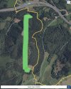
Here are some recorded in September, lots of pictures and commentary about dangerous dogs!!!!


And total agreement on the blocked trails — this person observed: “si no se pone remedio pronto no se podrá pasar por el camino de Las Palancas.“
 
did you by any chance record your tracks?
Laurie, I have yet to figure this out. I was sorry not to have pictures of the more horrendous parts, the grass tangled feet and poles too and self preservation took over & I was trying to stay upright.
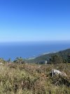
The views once you crested the mountain were gorgeous.
I do not understand the rampant vandalism on this stage. Painful.
 
On the 6th of October of this year I walked the official Camino from Soto de Luiña on the Norte. I had been looking forward for months to walking this route por Palancas. I took a left hand turn at the markers toward the mountain. Most Peregrinos take the coastal route forward on the road.

WARNING ⛔️: At this point in time the route is impassable. Grass is knee high and tangles your feet even with poles. In places the grass reached my hat. The thorns reached my waist. The descent was steep and difficult. There were good stretches on the logging road. A big cow trekked me & stood her ground.

Once you cross AS-268 and enter the woods, the trail which parallels the road becomes much worse. There is a long-standing thick fallen tree that I could not climb over and had to slide down a ravine towards the right holding on to tree branches and then scrambling back up. Pity that TSA confiscated my machete and I had not signed up for an episode of National Geographic. For the first time ever I ran out of water on a Camino despite carrying 2.5 L, this friendly neighbor and her cat so kindly offered me water.

The worst part of it was the vandalism of the mojones, recently placed and at great cost, which were thrown on the ground, some dragged and hidden, some purposely placed in the wrong way. So demoralizing to witness. Thankful for GPS Buen Camino & Wise Pilgrim.
Well done good photos! Are you sure it was a cow? It looks to me like something that could be in a bull ring somewhere!
 
The one from Galicia (the round) and the one from Castilla & Leon. Individually numbered and made by the same people that make the ones you see on your walk.
In 2017 June 13th I was looking exactly at this signpost and while I went into the forest, a car came along and stopped beside me. A friendly Spanish told me that I should avoid this path, as there will be no food and no water and probably fog to. I listened to him and I think it was a good decision on this rainy day.
 
In 2017 June 13th I was looking exactly at this signpost and while I went into the forest, a car came along and stopped beside me. A friendly Spanish told me that I should avoid this path, as there will be no food and no water and probably fog to. I listened to him and I think it was a good decision on this rainy day.
The total distance is about 20 km. The path itself is beautiful. I suspect Peregrinos are diverted from this route and towards the more “commercial” route with plenty of infrastructure. If more opted for the “official” route it would be in better shape.
The vandalism is unconscionable. I don’t know if there is a Xunta equivalent in Asturias.
 
Ideal pocket guides for during & after your Camino. Each weighs only 1.4 oz (40g)!
I think it’s a good idea to link two threads that describe very different experiences. Anyone planning to take the Palancas “high route” rather than the road route from Soto, should read them both. We’ve heard about lack of trail maintenance on several of the untraveled routes, and time of year is going to make a huge difference in terms of how dense the ground cover is if no one is walking.

There’s no denying the beauty of the views, but it sounds like it is sometimes not a great walking experience. And given the marker vandalism, anyone who walks this alternative should have GPS, IMHO.
 
Perfect memento/gift in a presentation box. Engraving available, 25 character max.
And given the marker vandalism
I wish we had a way to address the vandalism. So much effort was placed very recently to mark this route and conserve old mojones and install new ones. Such destruction. Can’t be to get Peregrinos on the coastal road with plenty of bars? Plenty of folks there already. Locals who are sick of Peregrinos? Seems rather unlikely. Vandalism for its own sake? I don’t know. It continues to bother me. What May we do? I personally let some Hospitaleros know & contacted Carlos Mencos editor of Buen Camino. Hoping our own Wise Pilgrim has seen this thread.

Attached picture is from one of the worst walking parts which is after coming down and have passed Cadavedo which is North East of here.
 

Attachments

  • IMG_3685.jpeg
    IMG_3685.jpeg
    1.2 MB · Views: 176

❓How to ask a question

How to post a new question on the Camino Forum.

Most read last week in this forum

Planning on walking Norte-Primitivo starting about June 10, 2025. Are the albergues very busy at that time and also what will the weather be? I did this the end of August and September of 2017 and...

Featured threads

❓How to ask a question

How to post a new question on the Camino Forum.

Featured threads

Forum Rules

Forum Rules

Camino Updates on YouTube

Camino Conversations

Most downloaded Resources

This site is run by Ivar at

in Santiago de Compostela.
This site participates in the Amazon Affiliate program, designed to provide a means for Ivar to earn fees by linking to Amazon
Official Camino Passport (Credential) | 2024 Camino Guides
Back
Back
Top