• ⚠️ Emergency contact in Spain - Dial 112 and AlertCops app. More on this here.
  • Remove ads on the forum by becoming a donating member. More here.

Search 69,459 Camino Questions

LIVE from the Camino Suspension bridge over the Orbe closed

irrie

Member
Time of past OR future Camino
2023 Camino Portugues 2024 Via Francigena
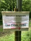
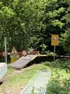
Today we were really looking forward to the walk in the gorge de l’Orbe (stage Jougne to Orbe) on the Via Francigena in Switserland. After the long steep descent from Ballaigues to the river Orbe (over 200 heightmeters) there was a sign at 10 meters from the bridge telling it was closed!!! Why not put that sign at the beginning of the descent in the village? We were very disappointed. It isn’t mentioned in the VF-app. The only thing we could do is to go to Le Day and take there the bus to Orbe.
 

Attachments

  • IMG_0995.jpeg
    IMG_0995.jpeg
    2.2 MB · Views: 448
  • IMG_0994.jpeg
    IMG_0994.jpeg
    2.6 MB · Views: 28
Get a spanish phone number with Airalo. eSim, so no physical SIM card. Easy to use app to add more funds if needed.
Just looking at the translation via Google...

"Temporary diversion. For work reasons, the I'lle footbridge will be closed from Monday June 17 and for an indefinite period; accordingly the river cannot be crossed at this location and we ask you to take the diversion put in place.

With thanks for your understanding. "

I imagine like a lot of the Apps, the developers have to be informed by "someone" of "changes" on the route...

Frustrating though.
 
It really depends on the maps you are using. In the SwitzerlandMobility Map it's marked close. Otherwise it helps to ask the local people in advance. As in the last days we had very bad weather in the southern part of Switzerland. I will start next Monday July 8th at St. Maurice and check the way again, in order not to be surprised. Also in Italy the had landslides.
 
€2,-/day will present your project to thousands of visitors each day. All interested in the Camino de Santiago.
Thank you, Irrie, for the warning, we will be walking there next fall. Hopefully the bridge will be open.

Paul-CH, thank you for the suggestion of the SwitzerlandMobility Map, a resource I was not aware of. However, when I look at it I do not see anything suggesting the bridge is closed. Has it reopened, or am I missing something? Any advice you can provide on reading this map would be appreciated.
 
Has it reopened, or am I missing something? Any advice you can provide on reading this map would be appreciated.
In order to see the closing you have to go to the settings (3 black lines on top left)
- Hiking in Switzerland need to be clicked (so you see the hiking paths
- Click on the Pedestrian on Passstelle de l'Ile in order to see the message for "Close and diversion"
- At the bottom of the page there is a description "Legend'
Hope this will help you and others
 

Attachments

  • SwitzerlandMobilityMap.jpg
    SwitzerlandMobilityMap.jpg
    636.8 KB · Views: 10
Any idea what this closure message means? It's on the section before BSP. And thanks for the suggestion for SwissMobility.

La Niord - Bourg-St-Pierre​

Duration
undetermined
Reason
Stone chipping
Status
validated
 
Ideal sleeping bag liner whether we want to add a thermal plus to our bag, or if we want to use it alone to sleep in shelters or hostels. Thanks to its mummy shape, it adapts perfectly to our body.

€46,-
Any idea what this closure message means? It's on the section before BSP. And thanks for the suggestion for SwissMobility.
Stone chipping translated falling rocks probably from the gray area on the mapoe above. We had a lot of rain and mudslides.
There is no „yellow diversion path“ marked. ⚠️ So better stay away
It seams like you are looking for an alternative route instead the marked path #70 VF
 
Last edited:
The closure just after Mouthier Saint Pierre is not mentioned in the Switzerland mobility app. It had been closed since 2022
 
The closure just after Mouthier Saint Pierre is not mentioned in the Switzerland mobility app. It had been closed since 2022
Correct as you mentioned Switzerland. The map shows something beyond the national border, but only paths in Switzerland 🇨🇭 are marked with closures. That's why the French and Italian maps exist. These are adapted by these countries.
 
The one from Galicia (the round) and the one from Castilla & Leon. Individually numbered and made by the same people that make the ones you see on your walk.
Correct as you mentioned Switzerland. The map shows something beyond the national border, but only paths in Switzerland 🇨🇭 are marked with closures. That's why the French and Italian maps exist. These are adapted by these countries.
How stupid of me!!!!! Ofcourse you are right.

I am now in the train from Lausanne back to Holland. We will be back early September to continue and will study the Switzerland app carefully.
 
In order to see the closing you have to go to the settings (3 black lines on top left)
- Hiking in Switzerland need to be clicked (so you see the hiking paths
- Click on the Pedestrian on Passstelle de l'Ile in order to see the message for "Close and diversion"
- At the bottom of the page there is a description "Legend'
Hope this will help you and others
Got it! What a fantastic resource! One more question: among the photos you posted were one of the sign and one showing the closed bridge. Can these be pulled from the map?

Thanks again for the info on this resource; I'm really glad to have it before we do the Swiss portion of the VF this fall.

Karl
 
3rd Edition. More content, training & pack guides avoid common mistakes, bed bugs etc
One more question: among the photos you posted were one of the sign and one showing the closed bridge. Can these be pulled from the map?
Oh no, you get only a descriptive text block with the reason for the closure, when you press on the sign "Pedestrians prohibited" on the map. If available, a deviation will be marked with orange color on the map.
You can download the SwitzerlandMobility App from Apple-Store or Google-Play for free. But if you wish to download the maps, drawing, recording own tracks you need the Plus Version CHF 30.-
But alternative you may use the swisstopo app.

The photos with the sign and the closed bridge have been posted bei irrie not be myself.
 
Last edited:
Technical backpack for day trips with backpack cover and internal compartment for the hydration bladder. Ideal daypack for excursions where we need a medium capacity backpack. The back with Air Flow System creates large air channels that will keep our back as cool as possible.

€83,-

Most read last week in this forum

Yesterday we left Mouthier Haute Pierre early because it would be a long steep stage (23,5 km with 849 height meters) with some difficult parts. So we rose early, had a good breakfast, packed...
Today we were really looking forward to the walk in the gorge de l’Orbe (stage Jougne to Orbe) on the Via Francigena in Switserland. After the long steep descent from Ballaigues to the river Orbe...
The VF del/nel Sud (other names are avaialble) goes from Rome to Bari (the embarcation point for onward travel to Jerusalem on the Via Egnatia) or on to Santa Maria di Leuca, the tip of the heel...

❓How to ask a question

How to post a new question on the Camino Forum.

Forum Rules

Forum Rules

Camino Updates on YouTube

Camino Conversations

Most downloaded Resources

This site is run by Ivar at

in Santiago de Compostela.
This site participates in the Amazon Affiliate program, designed to provide a means for Ivar to earn fees by linking to Amazon
Official Camino Passport (Credential) | 2024 Camino Guides
Back
Top