-
 ⚠️ Emergency contact in Spain - Dial 112 and AlertCops app. More on this here.
 -
Remove ads on the forum by becoming a donating member. More here. -
Get your Camino Frances Guidebook here.
Search 74,075 Camino Questions
You are using an out of date browser. It may not display this or other websites correctly.
You should upgrade or use an alternative browser.
You should upgrade or use an alternative browser.
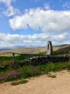
Ruins of a tower between Hontanas and Castrojeriz
- Thread starter Bert45
- Start date


3rd Edition. Vital content training & pack guides avoid common mistakes, bed bugs etc
- Time of past OR future Camino
- 2016, 2022, 2023, 2024, planned 2025
Pilgrim9
Active Member
- Time of past OR future Camino
- SJPdP-SdC (2017)
SdC-Muxia-Fisterra-SdC (2017)
Lisboa-SdC (2018)
Ferrol-SdC (2018)
The mysterious tower is at
(42.3108327, -4.0686831)
In my overstimulated imagination, it was attached to a rural residence, and the little porthole near the top enabled the country folk who lived there to sit inside and keep an eye on the doings of the big city folk in Hontanas, without themselves being seen.
(42.3108327, -4.0686831)
In my overstimulated imagination, it was attached to a rural residence, and the little porthole near the top enabled the country folk who lived there to sit inside and keep an eye on the doings of the big city folk in Hontanas, without themselves being seen.
Last edited:

A selection of Camino Jewellery

Hmm. A village called San Miguel? I'd expect more ruins. A mill? I'm ruling nothing out. I wish (just a bit) that I'd walked the 'real' camino from Hontanas to Castrojeriz, rather than taking the easy route along the smooth, level, tarmac road. [Don't condemn me! I walked the real, i.e. signposted, camino in 2003, but I was using film in those days, and probably felt I could not spare a frame for that structure.] I could have had a closer look at the tower. Is it a tower, even? It seems too small in width (both ways) to have a staircase within it. It cannot be a water mill, as there is no stream nearby. Windmills are not common round there – at least, I've never seen one.
Last edited:
- Time of past OR future Camino
- To Santiago and back. Le Puy to Aumont-Aubrac.
Erm ... everybody can see that that's not the ruins of a mill in the photo, whether water or wind driven.
Brierley merely writes that the path takes you past the ruins of an old mill and the ruins of an abandoned (medieval) village called San Miguel. He does not say whether he saw either of them and how close they are together but he probably noticed what's left of the church tower. Who doesn't? The website of the town of Hontanas has photos of both ruins - the mill and the tower.
Brierley merely writes that the path takes you past the ruins of an old mill and the ruins of an abandoned (medieval) village called San Miguel. He does not say whether he saw either of them and how close they are together but he probably noticed what's left of the church tower. Who doesn't? The website of the town of Hontanas has photos of both ruins - the mill and the tower.
Pilgrim9
Active Member
- Time of past OR future Camino
- SJPdP-SdC (2017)
SdC-Muxia-Fisterra-SdC (2017)
Lisboa-SdC (2018)
Ferrol-SdC (2018)
The tower might have served a mundane purpose such as, for example, anchoring overhead electrical cables and feeding them down (inside the tower) to a transformer or switchgear housed in a small attached stone cabin. That would be consistent with the compact footprint of the building rubble seen in overhead view.
I have seen in northern Spain similar narrow stone towers that are actually electrical system structures, including one in 2017 about 500 metres north of the CF somewhere along the meseta high ground, just before the CF descended into one of the river valleys. When I walked by the site in 2022 the stone tower had been razed and replaced by a steel tower.
I have seen in northern Spain similar narrow stone towers that are actually electrical system structures, including one in 2017 about 500 metres north of the CF somewhere along the meseta high ground, just before the CF descended into one of the river valleys. When I walked by the site in 2022 the stone tower had been razed and replaced by a steel tower.

€2,-/day will present your project to thousands of visitors each day. All interested in the Camino de Santiago.

It seems there are two streams near to the tower (Garbanzuelo and Valderubaya), but not near enough for the tower to be part of a water-mill. Google Maps marks the tower "Ruinas de una torre".
I've looked for the website of Hontanas. Found this: https://www.hontanas.es/inicio . Clicked on 'Galería de Imágines.' Two photos! Both of the church. Hardly what I'd call a 'Gallery'. So I clicked on 'Lugares de Interés. I found Molino del Cubo, a photo of mill wheels covered in 15cms of snow - ver mas - click - a map! A marker on Calle Manzana. Then I went to Iglesia de San Vicente - ver mas - a map! A marker on Calle Manzana – the same place! Nobody's prefect, I always say . In fact, all 6 places of interest are in the same place on the map. But I'll take "Ruins of the Church of San Vicente" as my caption. It's quite a long way from Hontanas, though. Was it the church of the village of San Miguel? Wait a minute! That doesn't make sense! The church of the village of San Miguel would surely be dedicated to San Miguel. There are three more photos that I didn't see at first. One makes it clear that the 'tower' is solid, and a description, translated, reveals: "These are the remains of the church of an ancient medieval village, which still preserves a corner wall." So it was a buttress, I think. I read that word somewhere in the last few hours, in connection with this topic, but I can't remember where.
I've looked for the website of Hontanas. Found this: https://www.hontanas.es/inicio . Clicked on 'Galería de Imágines.' Two photos! Both of the church. Hardly what I'd call a 'Gallery'. So I clicked on 'Lugares de Interés. I found Molino del Cubo, a photo of mill wheels covered in 15cms of snow - ver mas - click - a map! A marker on Calle Manzana. Then I went to Iglesia de San Vicente - ver mas - a map! A marker on Calle Manzana – the same place! Nobody's prefect, I always say
. In fact, all 6 places of interest are in the same place on the map. But I'll take "Ruins of the Church of San Vicente" as my caption. It's quite a long way from Hontanas, though. Was it the church of the village of San Miguel? Wait a minute! That doesn't make sense! The church of the village of San Miguel would surely be dedicated to San Miguel. There are three more photos that I didn't see at first. One makes it clear that the 'tower' is solid, and a description, translated, reveals: "These are the remains of the church of an ancient medieval village, which still preserves a corner wall." So it was a buttress, I think. I read that word somewhere in the last few hours, in connection with this topic, but I can't remember where.
Last edited:
- Time of past OR future Camino
- Us:Camino Frances, 2015 Me:Catalan/Aragonese, 2019
It cannot be a water mill, as there is no stream nearby. Windmills are not common round there – at least, I've never seen one.

Horse mill - Wikipedia
It is significant, perhaps, that the road leading out of Hontanas towards the Camino Santiago Francés is named as Camino del Cubo. 'Cubo' means 'mill-pond' (among other things) which ties in with 'Molino del Cubo' on the Hontanas website. So, although the 'tower' is some distance from a stream, the molino must have been on one of the streams.Horse mill - Wikipedia
en.wikipedia.org
3rd Edition. Vital content training & pack guides avoid common mistakes, bed bugs etc
- Time of past OR future Camino
- 2016, 2022, 2023, 2024, planned 2025
I am not a historian. I have taken thousands of photos on my caminos. I like to caption them with information about the subject of the photo. I sometimes get the information I need from something displayed next to the subject, sometimes I get information from the internet. Unfortunately, it seems that, if I look at two results from a Google search, the information is different, like with the Casa de Tejada. Then I turn to the forum. I also turn to the forum if I cannot find any information on the internet. This was a case where I couldn't find any information about the 'tower' on the internet. But I wasn't looking in the right place. The information is there, on the Hontanas website, but I might not have found it, even then. Because of the photos, I suppose you could say I'm really interested in the history of places on the internet.Question: @Bert45 you are often asking questions about specific places and sites. Are you a historian or just really interested in history of the places on the Camino.
mattythedog
Active Member
- Time of past OR future Camino
- 2016-2023 and future caminos planned
Mills are not all powered by wind or water. Humans and animals can be used.Hmm. A village called San Miguel? I'd expect more ruins. A mill? I'm ruling nothing out. I wish (just a bit) that I'd walked the 'real' camino from Hontanas to Castrojeriz, rather than taking the easy route along the smooth, level, tarmac road. [Don't condemn me! I walked the real, i.e. signposted, camino in 2003, but I was using film in those days, and probably felt I could not spare a frame for that structure.] I could have had a closer look at the tower. Is it a tower, even? It seems too small in width (both ways) to have a staircase within it. It cannot be a water mill, as there is no stream nearby. Windmills are not common round there – at least, I've never seen one.

Get a spanish phone number with Airalo. eSim, so no physical SIM card. Easy to use app to add more funds if needed.
- Time of past OR future Camino
- To Santiago and back. Le Puy to Aumont-Aubrac.
You can see the ruins of the mill from the Camino (I don't recall that we noticed it. We certainly did not see the millstones). It is next to the stream called Garbanzuelo. You can see the location in Google Earth. It is to the left of (south of) the Camino de Santiago, about 500 metres before you reach the church ruins. Apparently, the millpond has disappeared but its dam can still be seen.It is significant, perhaps, that the road leading out of Hontanas towards the Camino Santiago Francés is named as Camino del Cubo. 'Cubo' means 'mill-pond' (among other things) which ties in with 'Molino del Cubo' on the Hontanas website. So, although the 'tower' is some distance from a stream, the molino must have been on one of the streams.

Another photo is here: https://es.wikiloc.com/rutas-sender...z-camino-de-santiago-157845115/photo-99054274
Last edited:
- Time of past OR future Camino
- Some in the past; more in the future!
I don't have any info on the ruin, but I was also quite struck by it when I walked past.

- Time of past OR future Camino
- To Santiago and back. Le Puy to Aumont-Aubrac.
I can't see that the church ruins are part of what is left of a buttress when you look at it from all angles, for example @jungleboy's great photo or the photo below. It looks like the facade, i.e. the front end, of these (to me) typical Spanish churches where the bells are not enclosed in a tower but are on top of a wall that is higher than the other three walls. There is probably a Spanish word for it. This would also fit with the traditional east-west orientation of medieval churches. @Bert45, you took your photo in the morning?a buttress


PS: Found it. The bell-gables or espadañas are a feature of Romanesque architecture in Spain. They replaced the bell tower beginning the 12th century due to the Cistercian reformation that called for more simplified and less ostentatious churches, but also for economical and practical reasons as the Reconquista accelerated and wider territory needed to be re-christianized building more churches and espadañas were cheaper and simpler to build. Today, they are a common sighting in small village churches throughout Spain and Portugal. (Wikipedia).
Last edited:

...and ship it to Santiago for storage. You pick it up once in Santiago. Service offered by Casa Ivar (we use DHL for transportation).
I took the photo at 11:20. One of the reasons that I undertook another camino earlier this year was to see the things I had read about or seen on the internet for myself. There were a few things I was still unable to see, of course, churches were locked, etc. But this discussion has highlighted a couple of things (the 'tower' and the mill) that I might need to make another camino to see for myself, even though I had resolved not to do another camino.I can't see that the church ruins are part of what is left of a buttress when you look at it from all angles, for example @jungleboy's great photo or the photo below. It looks like the facade, i.e. the front end, of these (to me) typical Spanish churches where the bells are not enclosed in a tower but are on top of a wall that is higher than the other three walls. There is probably a Spanish word for it. This would also fit with the traditional east-west orientation of medieval churches. @Bert45, you took your photo in the morning?
View attachment 179888
PS: Found it. The bell-gables or espadañas are a feature of Romanesque architecture in Spain. They replaced the bell tower beginning the 12th century due to the Cistercian reformation that called for more simplified and less ostentatious churches, but also for economical and practical reasons as the Reconquista accelerated and wider territory needed to be re-christianized building more churches and espadañas were cheaper and simpler to build. Today, they are a common sighting in small village churches throughout Spain and Portugal. (Wikipedia).
The site around the remains of the church (which I used to call the tower) looks remarkably clear. We'll probably never know why the church (and village?) was abandoned, but, once that happened, it is likely that people took nicely carved blocks of stone from the church and other buildings to build their houses and barns elsewhere. But why did that stop, leaving what remains of the church? Another question with no answer.
- Time of past OR future Camino
- To Santiago and back. Le Puy to Aumont-Aubrac.
The reason for my question / assumption that you took the photo in the morning: the direction of the shadow of the “tower” in your photo and the common east-west orientation of Christian churches in the Middle Ages.I took the photo at 11:20

Wombat
Member
No one has mentioned the ruins in the valley at 42.31052062398464, -4.062017907462965 (paste this into google maps) This is probably the mill referred to in Brierley . Spanish topographic maps show 2 stream channels in the valley and the northern one is probably a leat. There appears to be a structure on this leat which could be a mill pond.
On Spanish topographic maps the tower is named as the "Torreón de Hontanas". The University of Burgos lists this site by the above name (coordinates check out) in an inventory (spreadsheet) and classify its type as "Castillo" (I searched for "Torreón de Hontanas" including quotation marks)
The tower has a good view down the valley towards San Anton and possibly was a defensible watch tower.
A selection of Camino Jewellery
- Time of past OR future Camino
- To Santiago and back. Le Puy to Aumont-Aubrac.
There is a photo of the ruins of the mill (at 42.31052062398464, -4.062017907462965) in post #13 and a link to a another photo.
There are excellent and clear photos of the other structure - 500 metres further along the Camino (at 42.3108327, -4.0686831) - from various sides that confirm what @Bert45 said already in post #4, namely that it cannot be part of a bell tower or a watch tower and why it cannot be so, even when it is referred to as a tower on the web and in this thread.
One cannot say that nobody has mentioned this or that it has not been discussed. This thread has only 20 posts so really not yet TL;DNR.
- Time of past OR future Camino
- To Santiago and back. Le Puy to Aumont-Aubrac.
I remain unconvinced about it being a defensible watch tower, and so should you and everybody else following this thread. You did not provide a link to this spreadsheet of "The University of Burgos" but I found one relevant spreadsheet on their site. It does list the ruins as "Castillo" (it is the classification taken from a specific database) but it also lists the ruins as "Iglesia" (classification in another apparently more accurate database). Here is the link and a translation of the most relevant entry:The University of Burgos lists this site by the above name (coordinates check out) in an inventory (spreadsheet) and classify its type as "Castillo" (I searched for "Torreón de Hontanas" including quotation marks)
Its ‘Original use’ has been corrected in this BB.DD with respect to the information in the PACU file, as it is in fact ‘the remains of the church of an ancient medieval settlement that still conserves a corner wall’ (Source: https://hontanas.es/lugares-de-interes/iglesia-de-san-vicente). // On Google Maps it appears as ‘Ruinas de Torre’ (Ruins of Tower). // It is located in the middle of practically inaccessible agricultural land. // The web text and the CBPJCYL image refer to the church in the village of Hontanas.
BB.DD and PACU are two different databases. The information in the spreadsheet is not direct original research about this one ruin, it is a collection of information retrieved from a variety of databases and similar sources about the cultural patrimony in Castilla and Leon. Never rely on just one source you found on the web, that's my guiding principle ...
Link: Inventario de Bienes de Interés Cultural del Camino Francés en Castilla y León. Spreadsheet. You need to download it because the columns are badly formatted and you cannot see the complete content of cells with long text when merely viewed online.
Last edited:
€2,-/day will present your project to thousands of visitors each day. All interested in the Camino de Santiago.
- Time of past OR future Camino
- To Santiago and back. Le Puy to Aumont-Aubrac.
@jungleboy, I have to thank you again for your excellent photo and for sharing it. It helps me to retain my sanity  . Below is a close up of your photo.
Am I the only one who see the tiles? The part of the wall where there was a continuation at the top of the photo as well as at the bottom of the photo? Where there is no continuation of the wall but where the wall ends smoothly? Where, at the top, there is the beginning of a round arch? The thin decorative ledge beneath it? That is a typical medieval bell gable as they had been built all over the place in their time.

. Below is a close up of your photo.Am I the only one who see the tiles? The part of the wall where there was a continuation at the top of the photo as well as at the bottom of the photo? Where there is no continuation of the wall but where the wall ends smoothly? Where, at the top, there is the beginning of a round arch? The thin decorative ledge beneath it? That is a typical medieval bell gable as they had been built all over the place in their time.
- Time of past OR future Camino
- Us:Camino Frances, 2015 Me:Catalan/Aragonese, 2019
Push hard enough on walls and they collapse leaving the corners because the piece of wall there is reinforced by the piece of wall behind it.

The 2024 Camino guides will be coming out little by little. Here is a collection of the ones that are out so far.

- Time of past OR future Camino
- Us:Camino Frances, 2015 Me:Catalan/Aragonese, 2019
Thank you @Kathor1 for the picture and explanation. We posted at the same time and not having studied the thread's pictures and posts closely enough I thought we were discussing a corner with the remnants of two walls that appeared to be a tower only from a certain angle. Your picture showed a third wall and I assume there is a fourth one still out of sight.Below is a close up of your photo.
There is an old thread that you may be interested in here:
As a person with very limited knowledge of architecture and history, I'd like to get some pointers on how to recognize different styles of architecture in Spain. It is overwhelming to google and find the huge amount of detail available - I need something a little more friendly, to get me started.
Rather than trying to go chronologically through history, let's start with one style that is often mentioned in connection with the Camino - Romanesque.
My challenge is for those unnamed members who wax poetic about Romanesque, to say in one sentence, how they recognize Romanesque when...
Rather than trying to go chronologically through history, let's start with one style that is often mentioned in connection with the Camino - Romanesque.
My challenge is for those unnamed members who wax poetic about Romanesque, to say in one sentence, how they recognize Romanesque when...
- C clearly
- art/architecture history
- Replies: 136
- Camino de Santiago Forum: Culture, History & Language for pilgrims


- Time of past OR future Camino
- To Santiago and back. Le Puy to Aumont-Aubrac.
Erm ... it's not my photo, it is @jungleboy's photo from post #14, and I had requested earlier today to have my forum name shortened.
Here is a photo of a medieval church building in Avila that has not fallen to pieces and is close in design and architecture to the Hontanas ruins. In Hontanas everything is gone except a bit of the higher wall where the bells were and a bit of the lower lateral wall, and they both formed a corner of the church.

Here is a photo of a medieval church building in Avila that has not fallen to pieces and is close in design and architecture to the Hontanas ruins. In Hontanas everything is gone except a bit of the higher wall where the bells were and a bit of the lower lateral wall, and they both formed a corner of the church.
Last edited:
Pilgrim9
Active Member
- Time of past OR future Camino
- SJPdP-SdC (2017)
SdC-Muxia-Fisterra-SdC (2017)
Lisboa-SdC (2018)
Ferrol-SdC (2018)
Am I the only one who see the tiles? The part of the wall where there was a continuation at the top of the photo as well as at the bottom of the photo? Where there is no continuation of the wall but where the wall ends smoothly? Where, at the top, there is the beginning of a round arch? The thin decorative ledge beneath it? That is a typical medieval bell gable ...
Good eye and good work, Kathor1.
Last edited:
The 2024 Camino guides will be coming out little by little. Here is a collection of the ones that are out so far.
- Time of past OR future Camino
- To Santiago and back. Le Puy to Aumont-Aubrac.
Now what's intriguing about the gable of the ruined church near Hontanas is this opening where you could think that it is a lookout if you did not know any better.
Is that a feature or a fluke? Something we will never find out?
There is a church in Catalonia with a bell gable and a similar opening, see the two photos below - it the same gable, once seen from the front and once seen from the back and the opening is clearly visible. There may be more ... we may have passed these small churches and we never noticed this nor did we take a picture.
- Time of past OR future Camino
- Us:Camino Frances, 2015 Me:Catalan/Aragonese, 2019
The architect was awarded the No Bell prize for this.
Kathor1 did at post #13.No one has mentioned the ruins in the valley at 42.31052062398464, -4.062017907462965 (paste this into google maps)
Ideal sleeping bag liner whether we want to add a thermal plus to our bag, or if we want to use it alone to sleep in shelters or hostels. Thanks to its mummy shape, it adapts perfectly to our body.
€46,-
€46,-

The first edition came out in 2003 and has become the go-to-guide for many pilgrims over the years. It is shipping with a Pilgrim Passport (Credential) from the cathedral in Santiago de Compostela.
- Time of past OR future Camino
- To Santiago and back. Le Puy to Aumont-Aubrac.
AlasI've looked for the website of Hontanas. Found this: https://www.hontanas.es/inicio . Clicked on 'Galería de Imágines.' Two photos! Both of the church. Hardly what I'd call a 'Gallery'.
! Not everybody is a talented web designer, and once the webpages are released to the online world, somebody has to maintain them and keep them up to date and correct errors and mistakes - this does not always happen, as we know only too well. And not everybody has a knack for finding stuff that may have fallen off the proverbial online waggon, so to speak.I found these two photos of the ruins on www.hontanas.es. They are, together with @jungleboy's excellent photo, perhaps the best that the online surfer can get
. Again, one can see clearly where there used to be a wall and where there wasn't a wall and how high these walls were and this helps to visualise what the building once looked like. A click on the thumbnails gives a better view (ruins seen from the east; from the west; from far): ...
... 
Last edited:
- Time of past OR future Camino
- Us:Camino Frances, 2015 Me:Catalan/Aragonese, 2019
More pictures of the tower if anyone is still interested:
 www.flickr.com
Flickr: Everyone's photos taken near 42°18' 39" N, 4°4' 07" W
The safest and most inclusive global community of photography enthusiasts. The best place for inspiration, connection, and sharing!
www.flickr.com
Both of those small holes, or openings, are at the same level as the axle on which the bell rotates. Is this a coincidence? Perhaps the hole allows access to the axle? For its installation or repair?Now what's intriguing about the gable of the ruined church near Hontanas is this opening where you could think that it is a lookout if you did not know any better.
Is that a feature or a fluke? Something we will never find out?
There is a church in Catalonia with a bell gable and a similar opening, see the two photos below - it the same gable, once seen from the front and once seen from the back and the opening is clearly visible. There may be more ... we may have passed these small churches and we never noticed this nor did we take a picture.
View attachment 179953
Get a spanish phone number with Airalo. eSim, so no physical SIM card. Easy to use app to add more funds if needed.
- Time of past OR future Camino
- 202?
I think you might get an answer if you started another thread. I am not an expert (of anything), but I would suggest it was the west façade of a church. The hole looks like one in one of Kathor1's photos, post #28. Or this on senditur.com: On leaving the village you can still see the ruins of what was the monastery of Foncebadón ...Not sure if I should start another thread for this, but – –
While we are talking about ruins, does anyone know the history of this ruin outside of Foncebadon?
There's a photo of it here: https://www.shutterstock.com/image-photo/ruins-church-steeple-foncebadon-leon-191521475 labelled as Ruins of a church steeple. 'Steeple' is the wrong word; Kathor1 found the right word: The bell-gables or espadañas are a feature of Romanesque architecture in Spain. (Post #15}
Last edited:
- Time of past OR future Camino
- To Santiago and back. Le Puy to Aumont-Aubrac.
Well done!!! I was not certain whether the opening is a window or an open space in a bell gable (known as espadaña in Spanish) of a church - the typical façade of old churches in Spain. And that's in fact what it is!I would suggest it was the west façade of a church. The hole looks like one in one of Kathor1's photos
I happened to see a recent article on ResearchGate that deals with these ruins near Foncebadon. The authors say that it could collapse any moment and discuss if and how it could be stabilised. There is also a drawing in this article which I copy-paste here. It shows the structure from the exterior of this church building and from the interior:

Source: https://www.researchgate.net/figure/Figura-8-Reconstruccion-de-la-parte-caida-de-la-torre-y-espadana-Alberto-Garcia_fig2_385140973
€2,-/day will present your project to thousands of visitors each day. All interested in the Camino de Santiago.
- Time of past OR future Camino
- Us:Camino Frances, 2015 Me:Catalan/Aragonese, 2019
I'm amused at the precision given here. I mean no offense; I can figure out that the coordinates were pasted in but the nerd portion of my brain has computed that the distance betweenThere is a photo of the ruins of the mill (at 42.31052062398464, -4.062017907462965) in post #13 and a link to a another photo.
42.310,-4.062017907462965 and
42.310,-4.062017907462966 is less than the diameter of a hydrogen atom (approximately 1.06 x 10^-10 meters).
An online tool gave the distance between 42.310,-4.06201 and 42.310,-4.06202 as 0.8 meters and we're 10 decimal points beyond that.
- Time of past OR future Camino
- To Santiago and back. Le Puy to Aumont-Aubrac.
Correct. Copy-pasted from the other poster’s comment in this thread. And I’m most certainly not going to spend any time on trying to figure out where the poster might have gotten these high precision numbers from or whether they are the result of some conversion calculation …I can figure out that the coordinates were pasted
Isaac Newton was guilty of calculating to too many decimal places, giving rise to spurious accuracy. Do you remember when we used books of mathematical functions, like logarithms, accurate to four figures? I still have mine. And now we have the internet.I'm amused at the precision given here. I mean no offense; I can figure out that the coordinates were pasted in but the nerd portion of my brain has computed that the distance between
42.310,-4.062017907462965 and
42.310,-4.062017907462966 is less than the diameter of a hydrogen atom (approximately 1.06 x 10^-10 meters).
An online tool gave the distance between 42.310,-4.06201 and 42.310,-4.06202 as 0.8 meters and we're 10 decimal points beyond that.
Get a spanish phone number with Airalo. eSim, so no physical SIM card. Easy to use app to add more funds if needed.
It's a feature of Google Maps. I just clicked on the 'Ruinas de una torre' and I only got 5 decimal places (42.31097, -4.06866) on the screen, but 42.31093519928673, -4.068673276491008 when I pasted here. You will see that the five-figures I saw on the screen are not the 14-decimal place figures rounded to five figures. Please don't try to explain – my brain can't handle any more!Correct. Copy-pasted from the other poster’s comment in this thread. And I’m most certainly not going to spend any time on trying to figure out where the poster might have gotten these high precision numbers from or whether they are the result of some conversion calculation …
- Time of past OR future Camino
- To Santiago and back. Le Puy to Aumont-Aubrac.
@Rick of Rick and Peg: Since you noticed the 14 digits after the decimal point and drew attention to it you may be interested in pursuing this further. The first webpage for convert coordinates that turned up in Google Search was Earthpoint where it says by way of an example:
Fourteen decimal places is obviously "a thing".
This page accepts a wide variety of latitude / longitude and position formats. For latitude, valid formats include:
N43°38'19.39"
43°38'19.39"N
43 38 19.39
43.63871944444445
Fourteen decimal places is obviously "a thing".
- Time of past OR future Camino
- To Santiago and back. Le Puy to Aumont-Aubrac.
And furthermore but I don't wish to spend too much time on it: 42.31052062398464 is just a value in some system or other. It does not measure anything in the sense of measuring distances in metres, centimetres or in fact nanometres or picometres. Perhaps a moot point had been raised? 

3rd Edition. Vital content training & pack guides avoid common mistakes, bed bugs etc
- Time of past OR future Camino
- To Santiago and back. Le Puy to Aumont-Aubrac.
I do! (I remember and I still have mine). And we now have not only the internet but also Wolfram Mathematica! Miracle software - you should try it!Do you remember when we used books of mathematical functions, like logarithms, accurate to four figures? I still have mine. And now we have the internet.
Fourteen decimal places is obviously "a thing".
exams.unnaturally.sizzle is accurate to 3 metres north-south and east-west, so they say.And furthermore but I don't wish to spend too much time on it: 42.31052062398464 is just a value in some system or other. It does not measure anything in the sense of measuring distances in metres, centimetres or in fact nanometres or picometres. Perhaps a moot point had been raised?
- Time of past OR future Camino
- To Santiago and back. Le Puy to Aumont-Aubrac.
Luckily, we don't have to parachute a tiny bedbug into the ruins of a mill off the Camino Francés and make it land on a pinhead. We just have to find the thing on Google Maps or Google Earth if we are curious enough. ")
It was I who first specified the location of the mill in this thread in post #13: "You can see the location in Google Earth. It is to the left of (south of) the Camino de Santiago, about 500 metres before you reach the church ruins." I thought that this description was precise enough and more informative than providing coordinates in whatever format. Little did I know ...
It was I who first specified the location of the mill in this thread in post #13: "You can see the location in Google Earth. It is to the left of (south of) the Camino de Santiago, about 500 metres before you reach the church ruins." I thought that this description was precise enough and more informative than providing coordinates in whatever format. Little did I know ...
Last edited:
Get a spanish phone number with Airalo. eSim, so no physical SIM card. Easy to use app to add more funds if needed.
- Time of past OR future Camino
- To Santiago and back. Le Puy to Aumont-Aubrac.
Tree-lined road from Hontanas to Castrojeriz; tree-lined stream; Camino Francés; ruins of "tower" and of mill; about half a kilometre between them.
For a better view, click to enlarge, then click on magnifying glass icon:

Source: Google Earth Pro
For a better view, click to enlarge, then click on magnifying glass icon:
Source: Google Earth Pro
- Time of past OR future Camino
- To Santiago and back. Le Puy to Aumont-Aubrac.
I am enjoying this.I'm amused at the precision given here. I mean no offense;
Basics first: How to convert coordinates of latitude and longitude from a notation in degrees, minutes and seconds to a notation in decimals? You take the º-number, the '-number divided by 60 and the "-number divided by 3600 and add them up. You see already that there are 3s involved in the divisor, so the result of this division and addition might have a lot of digits after the decimal point. If you use a simple calculator as the one on an iPad, your calculator will display the result with the first 14 digits after the decimal point - even more digits follow when you do this on paper or in your head.
So that's all there is to it: In the Google Earth app, the latitude of the mill is displayed as between 42º18'38"N and 42º18'37"N, depending on where the pointer is put on this structure. So precision is in the "seconds" range. Convert it - or have it converted - to a decimal format and you get a number with a long tail. But no matter how long or short the tail is when it is posted in a thread: When you copy-paste these numbers for latitude and longitude in decimal format into Google Maps or Google Earth, you see where the mill is.
No offense taken. It was a pleasure and it is now my turn to be amused.
- Time of past OR future Camino
- Us:Camino Frances, 2015 Me:Catalan/Aragonese, 2019
Way off topic but here goes anyway.
I still have my CRC book of math tables also but it is buried in the attic; a few slide rules are floating around too. I had three years of university mathematics up to partial differential equations but all I use or need now is arithmetic. I did inscribe my book with this back when I actually used it:
Also, back in those days pocket electronic calculators were coming out and making the books nearly obsolete. One company was selling a load of defective ones. They said they were perfect except for taking the sine of 0⁰ (maybe it was the cosine). I vaguely remember them being sold for $300+. That was three months room and board at my dorm.
Do you remember when we used books of mathematical functions, like logarithms, accurate to four figures? I still have mine.
I do! (I remember and I still have mine).
I still have my CRC book of math tables also but it is buried in the attic; a few slide rules are floating around too. I had three years of university mathematics up to partial differential equations but all I use or need now is arithmetic. I did inscribe my book with this back when I actually used it:
To bear offspring, Noah's snakes were unable.
Their fertility was somewhat unstable.
He constructed a bed
Out of tree trunks and said,
"Even adders can multiply on a log table."
Also, back in those days pocket electronic calculators were coming out and making the books nearly obsolete. One company was selling a load of defective ones. They said they were perfect except for taking the sine of 0⁰ (maybe it was the cosine). I vaguely remember them being sold for $300+. That was three months room and board at my dorm.
...and ship it to Santiago for storage. You pick it up once in Santiago. Service offered by Casa Ivar (we use DHL for transportation).
Blue Tang
Member
- Time of past OR future Camino
- Camino Francés, 2022, 2024; Caminho
Português 2018
Here's a wide angle view of the approach to the Ruina de una torre from June, 2024.Tree-lined road from Hontanas to Castrojeriz; tree-lined stream; Camino Francés; ruins of "tower" and of mill; about half a kilometre between them.
For a better view, click to enlarge, then click on magnifying glass icon:
View attachment 180097
Source: Google Earth Pro

Dagaro17
New Member
- Time of past OR future Camino
- Camino Frances 2010, Camino Frances (August 2024)
I passed by there 11 days ago and was also intrigued by the tower. I have a digital copy of the Gitlitz and Davidson book “The Pilgrimage Road to Santiago, The Complete Cultural Handbook” which I highly recommend. It states “Valdemoro on a hillside to the north of the walking road, about 2 km. beyond Hontanas, are minimal remains of the village of Quintanilla de Valdemoro, documented in the 12th c. The only sizable ruins are of the church of San Vicente.” The hontanas.es website corroborates this. Around the ruins are remnants of tiles, ceramics and human bones. There were even some human teeth  It was spooky as it was misty when I was there.
It was spooky as it was misty when I was there.- Time of past OR future Camino
- To Santiago and back. Le Puy to Aumont-Aubrac.
@Dagaro17, I join your recommendation for this excellent Cultural Handbook for the Pilgrimage Road to Santiago.Gitlitz and Davidson book “The Pilgrimage Road to Santiago, The Complete Cultural Handbook” which I highly recommend
Just to avoid any misunderstandings: I don't think that human bones and human teeth are lying around there. There was a village (or rather at least two villages) between Hontanas and the San Anton site, and they had a church and a cemetery. I guess that these items were found during archaeological digs. Dentin (the material that teeth are made of) is harder than bone and lasts much longer.
It is often not clear what the original source of this kind of information is. In this case, one of these sources is mentioned on the Hontanas website: A document about a donation that the king made in 1221 to a bishop in Burgos, namely the lordship (i.e. territory and income) over duas villas quarum una dicitur Val de Moro et altera dicitur Quintanella, inter ipsam Val de Moro et Fontanas, in strata Sancti Jacobi - two villages named Val de Moro and Quintanella, between the Val de Moro valley [I think] and Hontanas [spelled Fontanas at the time] on the road of Saint James.
...and ship it to Santiago for storage. You pick it up once in Santiago. Service offered by Casa Ivar (we use DHL for transportation).
Dagaro17
New Member
- Time of past OR future Camino
- Camino Frances 2010, Camino Frances (August 2024)
Thank you Kathor1 for your reply and that information. You are way more informed than I about the history. I love learning. When I get home in a couple of days I’ll post some pics that I took at the base of the tower of the bones, ceramics, teeth, etc. I can’t seem to post pictures with just cell service even after multiple tries. I’m in Santiago right now.


❓How to ask a question
How to post a new question on the Camino Forum.
Most read last week in this forum
https://www.theguardian.com/world/2024/dec/22/spain-el-gordo-huge-christmas-lottery-logrono-winners
Hi! I'm planning to do the Camino Francés in a month starting January 22nd from SJPDP to Santiago. Can you tell me the alternative routes and albergues that are interesting and that I must...
Hello fellow pilgrims, I'm working to book my first Camino in May 2025. One of the things I love about walking is seeing all of the flora and fauna along the way. I'll be starting SJPP in early...
Hi. I've been reading posts for a couple months now, and the info here is excellent. I recently read that the French camino is the busiest and especially in May. What is "busy"? My husband and I...
I am looking at flying into Paris and getting a train to Bayonne and another to SJPDP the trains seem very convenient from Paris any other suggestions for a comfortable and fast trip ?
Similar threads
- Replies
- 1
- Views
- 619
- Replies
- 0
- Views
- 243
- Replies
- 16
- Views
- 861
❓How to ask a question
How to post a new question on the Camino Forum.
Forum Rules

Camino Updates on YouTube

Most downloaded Resources
-
 “All” Albergues on the Camino Frances in one pdf“All” Albergues on the Camino Frances in one pdf
- ivar
- Updated:
-
 A selection of favorite albergues on the Camino FrancésFavorite Albergues along the Camino Frances
- Ton van Tilburg
- Updated:
-
 Profile maps of all 34 stages of the Camino FrancesProfile maps of all 34 stages of the Camino Frances
- ivar
- Updated:
