• ⚠️ Emergency contact in Spain - Dial 112 and AlertCops app. More on this here.
  • Remove ads on the forum by becoming a donating member. More here.

Search 69,459 Camino Questions

GR130 @ La Palma: any advice?

JustOneGuy

Active Member
Time of past OR future Camino
Aug 2024: GR130, Apr 25: Camino Primitivo?
I don't know if it is allowed here to talk about "caminos" not connected with Santiago or at least with the Iberian Peninsula, but I'll try anyway. At the end this is Spain too!

For mainly logistical reasons, I am considering (along with various other options) the possibility of doing the GR130 on the island of La Palma (Canary Islands) end of August.

The main reason is that I have lived in La Palma for years and know the place. It also passes close to my house, which would essentially allow me to... lock the door and leave, without flights and other expenses. And with the bonus of calling a taxi or a friend in case something goes wrong... :cool:.

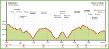
The GR130 is about 150 km long, is quite mountainous, but many people do it in 7-8 stages. Here is a summary. For various reasons (mainly to do the more mountainous section at the end) I would prefer to do it clockwise instead of counterclockwise, as is rather the norm.

One problem is that the recent 2021 lava flow interrupted a section, but I know how to cross it anyway...

I was wondering if any of you experienced walkers have done it and have any advice for me, particularly on difficulties related to the northern part and in finding accommodation without booking in advance.

Then, if it will work, in April-May 2025 I would do an actual "Camino de Santiago", together with my partner.

Many thanks to anyone who can give me some advice and... buen camino!

p.s. I add a map of the hike for clarity from komoot:

1722969453477.png
 
Last edited:
€2,-/day will present your project to thousands of visitors each day. All interested in the Camino de Santiago.
I've never been, and so can't really help with your questions, but the GR130 looks like a great hike! As you are still anxious about setting out on a camino, a hike such as this, on your home turf and hopefully within your comfort zone, should really help give you the confidence you need.
 
Thanks for the encouragement @Flog.

I am studying the route and one thing I was a little worried about is a 28.5 km northern stage with an elevation gain of... 2,656 m. The track is low altitude (max 600 m asl) but does continuous very steep climbs and descents between "barrancos" (ravines) above a steep cliff on the ocean, although with spectacular ocean views and a permanent breeze thanks to the trade winds, in a very wild environment.

1723026949234.png

Fortunately, I found that there is an albergue at El Tablado where to spend one more night... :)
 

Attachments

  • 1723026942387.png
    1723026942387.png
    153.6 KB · Views: 7
Last edited:
€2,-/day will present your project to thousands of visitors each day. All interested in the Camino de Santiago.
This afternoon I did another preparatory test: I took a stage of the GR130, modified it so that I could start from my home, and it ended up being a 3 1/2-hour walk of 16.2 km, with an ascent of 470 m and a descent of 660 m. No stops at all and a light (3.5 kg) backpack.

I largely covered a route I usually take by car or bike, but on adjacent roads, and as usual I was amazed at how the world, even the one you are most used to, completely changes face if you walk it.

Everything seemed more pleasant, intimate and friendly. A bit like some of the islands in southern Italy, my country, which I left a few decades ago. The Camino Real was the original old connecting road, but now the roads are too narrow, twisted, with the old covering of irregular, sharp basalt stones, for ordinary traffic. And I met NO ONE walking the GR130 except a few locals that made me feel this is the right choice.

All these beautiful Canarian-style houses seemed deserted! Even when I was doing my running workout years ago, I couldn't notice some of the details, the beautiful euphorbia, the bougainvillea that are overloaded with inflorescences of all colors this time of the year, the many Canary Palms (oh yeah... there must be a reason why it's called La Palma...).

But especially the Draco Draconis, the plants with the characteristic sap red like the blood of a dragon, which have become my favorite tree since I live here!

Back on earth--I also tested some equipment and...

"Svolazzini" (or "short pants", apparently, in English: they are the usual very short and light pants used by runners): great on the road, light and airy. A little less so in sections with vegetation, often too thick not to scratch my legs. 4 out of 5 stars but they are so light I will probably add one pair to the packing list...

Osprey Sirrus 26L backpack ("stolen" from my wife--I wanted to try it in case I could shove it all in): I must not be very sensitive because even though it was "women's" model, it went great. OK, only 3.5 kg, but I'd say it could be done. 4 out of 5 stars just to be conservative.

HOKA Speedgoat 5 Trail Running shoes: great as always. I have used them for many years now. New version is even better. They wrap the foot and hold up on any terrain. Only problem: they are very noisy, something that bothers me a bit on asphalt. 4/5. Again.

Garmin watch 645 / Komoot: I had set the route on Komoot so that I could orient myself by looking directly at the watch instead of the phone: it really worked great this time! The voice of the little lady hiding in my phone and alerting me every 10 seconds yesterday (on the bike) that I had "abandoned the route" was not missed at all! Too bad the battery suffered a lot from the constantly ON display: in 3 1/2 hours it went from 98% to 37%. But with an occasional charge on the spare battery during stops, it should be enough. And the directions are much much better, even without a map. 4/5 also for the combo...

Single walking stick (rather than both): I wanted to test whether I was better off with one stick: sure, it means always having one hand free, but it's also true that as soon as the terrain is rough or a bit sloping to the side you miss the other stick: 3/5.

Overall status
: all in all I feel good, despite an ebike heavy tour (where I got almost lost) in the mountains yesterday. My right knee, the one that hurts a bit, doesn't seem to give me any problems. I would say I can do the tour: 4/5.

1723415834664.png
an humble section of the Camino Real. No one around for many km...
 
Last edited:
I love La Palma have done some day walks and volcano route. The Camino de Santiago is much less challenging.
I haven’t done the route you are suggesting but it sounds as if you are very fit.
I look forward to your report. Wishing you good luck with the walk.
 
Thank you, Bella, for your kind words of encouragement.

And thanks but... I don't think I'm "very fit" 🤨 , but considering that I have 6-8 hours a day to complete this stage (instead of 2-3 as in my current training), I should be able to do it. With a total climb of 5,250 m, it will certainly be a challenge for me.

Regarding La Palma, I am sending you something I found marked in the concrete yesterday:

1723461869879.png

I do not know if you are able to read it, but it says:

La Palma no se vende, se ama y se defende

(La Palma is not for sell, one must love and defend it).

And it says it all, IMO...
 
Last edited:
A selection of Camino Jewellery
I don't know if it is allowed here to talk about "caminos" not connected with Santiago or at least with the Iberian Peninsula, but I'll try anyway. At the end this is Spain too!
It certainly is! Hence the "other routes in Spain" tag. The forum also has one for other pilgrimages and walks around the world.

I really like the map, particularly how the various sections are in different colors -makes it so much easier to see.
The elevation chart is also very good.
Great that you found an additional Albergue at El Tablado, 28 ks in that terrain would be quite a day!
Sounds like your training is going well, I too look forward to your report.
 
This afternon, for practice, I did another piece of the Camino Real, this time heading south. It is a path through time, it really feels like traveling 100 years ago. Nobody around. Just an elderly lady with a disabled son in a wheelchair who was airing him out near their house. I greeted both of them, almost ashamed that I could walk expeditiously for pleasure..

I had biked this road several times, but on an e-bike you have to look ahead carefully, as the terrain covered with old, large basalt stones is very uneven. And therefore you don't have time to really enjoy the scenery. When you do it walking, it's like you've been projected into a parallel universe....

On the route there are many fountains (3 in a little more than 10 km), many things to see, many plants, but the thing that struck me the most today was this legend, found in front of a crumbling house. Being Italian, though not Sicilian, it intrigued me even more....

1723582363140.png

Casa del Sicilia:

1723582386560.png
 
Hi Guys,

I have a bit of a problem with my plan. The only week I can do this tour (work reasons) it is not easy to find hostels in certain parts of the island. Extending to hotels leaves only overpriced options (3-400 euros per night).

I have to stretch some of the stops and in particular one that is quite hard:

1723831602633.png
1723831629173.png

It's the ascent and descent that worries me. There no shortcut possible in the area. The only alternative is to camp free, but this would mean 3-4 kg more all the time.

What do you think? 1,200 m ascent in a day (sometime in difficult terrain) looks a bit too much to me.
 
The one from Galicia (the round) and the one from Castilla & Leon. Individually numbered and made by the same people that make the ones you see on your walk.
How hard and expensive would it be to get a taxi to and from some nearby point?
Is that even conceivable?

Edited to add: does anyone you know have a simple bivouac or light tent option?
Or could you simply drive or post your tent to your night before's stop pick it up the and then collect it from the next night stop at a future point?
 
How hard and expensive would it be to get a taxi to and from some nearby point?
Is that even conceivable?
it's funny but before reading your comment @Peterexpatkiwi I was out to dinner with friends to whom I told about the problem. The reaction of one of them was immediately “okay, but you can always call a cab!”.

For some reason my brain had completely removed this obvious possibility.... :confused:
 
Last edited:
I just returned from another hike in the mountains nearby. The idea was to check the state of my physical preparation, to fine-tune my equipment, and to see how I reacted to the deadly heat of this period.

14 km with 850 m of elevation gain in theory without major problems. But...there is a but: the heat today was deadly and displaced me. The temperature indicated by the car was 29 on the way out and 32 C on the way back. But here in La Palma there is a very strong atmospheric inversion layer and it was certainly warmer at mid altitude, especially on the way back. I left around 11 a.m. and returned around 5 p.m. after eating at the top of this 1854 m mountain from where you can see the whole crater of Taburiente, the ancient volcano that gave rise to this island. I had chosen this late hour on purpose and brought with me 1.5 L of water and 0.5 of a protein liquid but it was not enough and I arrived at the car very thirsty.

My idea during the island tour would be to leave very early in the morning, but the west side of the island is still very, very hot. I wonder if it is a good idea to do this long hike in late August, when the average temperatures here peak. But if I postpone I will have to wait until late November. Which is fine but would annoy me a lot.
 
Last edited:
The one from Galicia (the round) and the one from Castilla & Leon. Individually numbered and made by the same people that make the ones you see on your walk.
Hi! No advise, just following. I'm planning to do a multiple canary island tour this october and Palma is high on my list. Your detailed walks are great, thank you!

Is the route signposted at all?
Any guidebooks or websites, apart from Komoot?
Info on the refuges? Where would I be able to find them and their opening details?

I can imagine that high summer may not be ideal, could a water filter help out? so that you can filter water on the way instead of carrying it in?

Enjoy the process!
Take care!
 
Hi! No advise, just following. I'm planning to do a multiple canary island tour this october and Palma is high on my list. Your detailed walks are great, thank you!
You're welcome!
Is the route signposted at all?
Actually signs are great for most of the routes. Always redundant, in particular on the GR-130 and 131.... except in a few points in my experience, and that's why I use Komoot on my Garmin watch.

BTW, yesterday I subscribed to Komoot Prime. I have to say that the map doesn't improve too much (at least on my Garmin watch), but for planning I felt the difference. You see a lot more information on the website, and you can create "collections" of walks, that helps a lot with multiday trips.

Unfortunately, my watch got completely discharged while I was driving back home (from 100% to a few % in less than 6 hours!)So, apparently I completely lost the record, that makes me crazy... Next time I will bring with me the power cable and will recharge during lunch and at any stop.
Any guidebooks or websites, apart from Komoot?
This is a classic. For what concern maps here I use a 1:30000 from freytag&berndt (in German) called... well... La Palma. Note that most of the resource are not updated after the 2021 Volcano lava that interrupted the connection from the South to the East. Now, things are improving but I do not know yet exactly how I will eventually walk through the solidified lava flow from Los Canarios to Los Llanos.

Websites:
This is the government official website. Very well done: https://www.mapa.gob.es/es/desarrol...turales/sector-canario/la-palma/default1.aspx

Info on the refuges? Where would I be able to find them and their opening details?
Try "Albergues" on Booking etc. I never tried them but some of them looks good. It's possible to do the full GR-130 using them, but not the GR-131 that needs free camping (illegal, but accepted so far, as there are not very many people walking... yet).
I can imagine that high summer may not be ideal, could a water filter help out? so that you can filter water on the way instead of carrying it in?
In most of the case the answer is no. On my hike today there were no fountains at all, and there is a single stream in the whole island. There are many big tanks for the platanos but they are not accessible.

On the GR-130 stages I did so far I found some fountains, but some of them were dry. Some others were not sanitized so a filter would help but most of the people drink them anyway. Some of these fountains are not marked on the map.
Enjoy the process!
Take care!
Well, I think I drank 3-4 liters of water since I got back home...

I almost killed myself in the Andes many years ago for the same reason: I was hiking (up to 4000m and more), but I underestimated the time it would take because I had to stop to let the snow melt. Problem: snow takes FOREVER to melt. In the end it took a day and a half longer than expected and I ran out of gas.

Not a drop of water for a day in a V-shaped valley where the temperature was unbearable. No people to ask. Really tough. Apparently one lesson is not enough for me...
 
Last edited:
Ideal pocket guides for during and after your Camino. Each weighs just 40g (1.4 oz).
Ding dong!

I am advising the kind forumist that I had to postpone my project for the following reasons:

1) in some stages the few places available in the Albergues have unfortunately filled up. I have looked for alternatives, but without success. This is my mistake, I should have guessed, but on Sunday there were still places and I was waiting a bit to see if I was in a condition to make it and waited until Tuesday (yesterday), when it turned out to be too late. All other options turn out to be way too expensive in August.

2) it's hot as hell these days, especially on the west coast.

3) maybe it is better to wait until I have better physical preparation. Things are getting better but I still have some discomfort.

4) In La Palma, the weather is always spring-like.... except in the middle of August and September, when the temperature and humidity go up a lot.

I had to struggle to convince myself but finally decided to postpone until the next time I am available, probably not before November

Too bad.
 
Last edited:
Further training today. I completed an entire stage (the first one of the GR130, the one from my home): 20.9 km, plus another mile and a half to get home from the bus stop that took me home.

Everything went very well. Frankly, no physical problems, despite 950 m of ascent and 750 m of descent. Foggy for 10 km, sunny for the remaining 10. 5:45 hrs.

Fantastic feelings, no permanent pain. Spectacular scenery.

It may not be as beautiful as Galicia, which to me seems particularly beautiful as scenery, but the fact that I met a total of only 4 people (a small group of runners training) makes up for everything and offers an unparalleled chance to meditate.

1724599862478.png

The intense scent of the Canary Pines... the walks in the forest, among the rocks of a recent lava flow, with the ocean always in view from the other along with three islands: la Gomera, Tenerife and El Hierro.

How beautiful it is to walk. I had forgotten that...

Actually, at the very end I also met this guy:

1724600071295.png
He certainly doesn't snore in the hostel, or bother you with idle chatter...
 
Last edited:
...and ship it to Santiago for storage. You pick it up once in Santiago. Service offered by Casa Ivar (we use DHL for transportation).
Yesterday I went on another training walk. This time a bit more difficult, both in terms of distance and elevation gain.

I chose to go on a trail called “los tuneles,” which passes, at least for a stretch, next to an ancient gully that collects water to carry it down to a low elevation. The route is curious because the gully, built on a steep and exposed cliff, passes inside 13 anciently excavated tunnels between 15 and 387 meters in length. These tunnels are carved into the rock, completely dark, cramped, and sometimes you have to slip to get through.

1725182812178.png


Many people here go up in small public vans that take them to the beginning of the trail via a dirt service road. I did it from the bottom, and then continue on and come back down the other side of a ernome “barranco” (ravine) that one skirts for miles. At first I went up through a dense forest of laurel and canary pines.

1725182984072.png

The path was very steep. In 6 km I climbed more than 800 meters. By the way, I had forgotten my trekking poles next to the car and had to go back after about 800 m (100 m elevation gain) to get them back. Damn distraction! :rolleyes:

Anyway, the mountain was bathed in a fog that made the landscape surreal. I never met anyone while going up. Once I got to the trail called “los tuneles,” I started walking by this gully, stopping often to let groups of people pass (only one in 10 thanked for the courtesy but... you know :mad: ).

1725183022541.png1725182812178.png

Everything was fine until tunnel 9, which is 94 meters long. The problem is that usually people walk to the side of the gully on mostly dry soil, But in tunnel 9 the water had invaded the other side as well, perhaps because it had rained until just before and the water was jetting out of the walls of the gallery. Usually people go back there but I had planned closed route so I had to go ahead.

1725182786659.png

So I decided to take off my shoes and socks and walk barefoot. The water was freezing so my feet started to hurt after a few meter. I would stop by resting them on the edge of the dry gutter and then start again. In one of these moments, Mr. Bean scene 😆! One of my shoes fell into the rivulet and began to float, descending rapidly downstream... :eek:

Terrified (I didn't much like the prospect of walking back without a shoe...) I rested my backpack in balance above the gutter so it wouldn't get wet, started running backwards, trying not to hit my head on the ceiling, and then chasing the shoe down the gully! A comic scene... I caught it again about 200 meters down, completely wet. At that point I got all tucked in again and did the infamous tunnel 9 with my shoes inside the water... The tunnel was flooded with jets of water everywhere, it looked like a Luna Park! I came out completely wet but in the end it was so much fun.... 😄

But the problems had not ended there....

I continued walking, again shrouded in fog but in a fairy-tale landscape and in total solitude, until I reached the highest point of the walk. There I had lunch in the company of two crows,

1725182756455.png

thinking about how to solve a problem: in fact, the trail was “temporarily closed.” Damn! Should I go forward or turn back? The prospect of turning back did not appeal to me, but neither did the prospect of descending maybe a couple of km only to find that the trail was actually impassable at some point and having to turn back anyway.

In the end I decided to try to continue. And in fact I did well. That part passed in solitude through steep walls, the bottom of a very narrow canyon, then another forest that felt like being in another universe. I think the reason it was closed (but couldn't they have signaled it at the beginning??) is that a landslide at one point in a very exposed spot forced some acrobatics, but in the end no big problem: I got back to the car with 32 km of trail done and 1400 m or so of elevation gain, all in decent physical condition. Which makes me convinced that I would have no problem tackling the island tour and then also a Camino de Santiago next spring!

This is where I thanked the idea of carrying my satellite GPS tracker with me at all times: all along the way there was a complete lack of signal, and if I had an accident, it would have been very difficult to find me and report the emergency.

The only thing, this time I was very disappointed with the app I use; Komoot. First, the weather forecast available in the Premium version, was completely wrong: it said 0% chance of rain while the whole area was in fog or rain. Then much of the route was incorrect. And in fact I was walking, even removing the initial mistake, for about 30 km instead of the planned 22. Something to remember...

1725183290691.png
 
Last edited:
Wow, adding 30% to the day’s walk is pretty significant! Is Komoot normally fairly accurate?
Thanks!... and... no, Komoot usually works fine. This time it didn't. However, signs are rare and sometimes hidden in the first part, and having the map on my watch was essential.
 
Last edited:
The focus is on reducing the risk of failure through being well prepared. 2nd ed.
Good evening everyone,

Last Monday I began to notice red specks on my left arm. On Friday I went to the doctor because they were hurting. I thought about an insect bite. Nope: herpez zoster (shingle) 🙄.

So far it doesn't hurt much, but I wake up constantly at night and have some accumulated fatigue. So, I wanted to go for a long ride today but didn't really feel good, maybe also because of the many medications. I read that it is better to rest in these cases, I guess so as not to weaken the immune system.

Has this happened to anyone? Is it appropriate to do long outdoor activities like a long walk? I wouldn't want to lose training again...

p.s. I take this opportunity to apologize to the mods who had to delete a couple of my posts that were a bit off topic actually. My most sincere apologies for the additional work.🫢
 
I only ever had a very mild dose of shingles about eight to ten years ago, as I wasn't walking much at the time I've got no idea. Frankly I really would ask your doctor you don't want to prolong it or jeopardize your recovery.
Good luck!
 

Most read last week in this forum

I'm just back from walking the Ruta del Padre Sarmiento, and wanted to give a summary of the stages and the general conditions for those who might be interested in walking it in the future...
If you like rugged coastal walking there is no better 7 day walk in Spain than the Galicia Camino de Faros (lighthouses). Tougher than any Camino I have ever done but spectacularly beautiful. And...

❓How to ask a question

How to post a new question on the Camino Forum.

Similar threads

Forum Rules

Forum Rules

Camino Updates on YouTube

Camino Conversations

Most downloaded Resources

This site is run by Ivar at

in Santiago de Compostela.
This site participates in the Amazon Affiliate program, designed to provide a means for Ivar to earn fees by linking to Amazon
Official Camino Passport (Credential) | 2024 Camino Guides
Back
Top