• ⚠️ Emergency contact in Spain - Dial 112 and AlertCops app. More on this here.
  • Remove ads on the forum by becoming a donating member. More here.

Search 74,075 Camino Questions

From the Puerto de Pajares to the Pueblo de Pajares on the Salvador --- PART2

I should start by clarifying that I have walked the Salvador twice. The first time was before Ender put in the wooden post with the bifurcation to the coffin route. The second time was afterwards.

So, yes, FatmaG and I may be the only two here (or maybe Thomas´s wife also) to have walked the original camino. When the wooden post wasn´t there yet, that meant that you kept going till the point where my photo shows the mojón with the two conch shells. At that point there was a turn-off for Pajares, with an option to continue descending to San Miguel. And as Fatma says, the route to Pajares didn´t go down to San Miguel -- it had an earlier turn-off. The problem is finding that camino on Gunnar´s map, but it must still be there.

I walked the original route, back in 2008 or 2009. It was pretty, but I was tired by then and couldn´t enjoy it.
 
€2,-/day will present your project to thousands of visitors each day. All interested in the Camino de Santiago.
Join the Camino cleanup. Logroño to Burgos May 2025 & Astorga to OCebreiro in June
I am officially leaving my coffin at home when I walk in June. Neither will I take an electric coil.
I have read this entire thread without actually comprehending anything and do not believe it will all become clear when I get there;-)
I'm counting on following the arrows Laurie leaves in May. Either that, or I'll look for the blue dots.
 
And. It's Susanna, not Suzanne. ;)
Oeps, sorry Susanna!:oops:

Thank you Thomas that was a very good pic of the power lines. :)
I'm impressed by Bing maps btw. I didn't know they were so good. Much better than google earth.
Thanks to Gunnar. I didn't know this either but he was the first one using bing maps in this thread. I was surprised too!

Thanks Laurie for the wrap up of this topic.
The first and final question is where a fourth route from the Puerto de Pajares is!
I must say that I still haven't got a clue....
 
Good morning!
Today I started my day by picking up my iPad and then I went for a walk around Puerto de Pajares in Bing maps.:)
On my wish list are two things.:)
1. I want a big map of the kind I posted yesterday. Did you see the names on it!? The valleys and hills around Pajares have names, isn't that nice to know? It's a bit tricky to get the maps though. Stuart posted a thread before, how to do it.
2. I want to find out a good place for a base camp. Where one can stay if one wants to walk all options from Puerto de Pajares to Pajares. There's got to be small pensions etc in other places than Pajares, in the area?
:)
 
€2,-/day will present your project to thousands of visitors each day. All interested in the Camino de Santiago.
Hello Laurie,
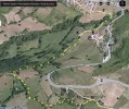
Well here is in detail how the camino should be starting from "u", also known as the "no thanks"-point, till Pajares without touching the N630. "x" should be the place where the coffin would arrive.

Is autovia maybe the name of a place? Because, there is no autovia - a track where cars can ride 120km/h on separate lanes - in the area.
The name of the bar that should be 200m before the agglomeration sign "Pajares" is "Meson El Ruchu" now labeled as "z". The place where the coffin carriers took a sidra and some tapas after the long trip?
On Susanna's posted map, you can see that there should be a shortcut behind the bar walking over the hill. It's in blue on her map and you would arrive in point "a".
On Susanna's map: look how nice they represented the power line.

pajares-map-no-thanks-yes-please.webp

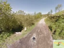
Lucky for us, the Google Street View car passed the "no thanks" "u" point
pajares-no-thanks.webp

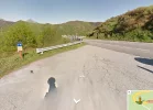
The "yes please"-peregrinos can anyway take the N630 for a while. (point 9)
pajares-yes-please.webp

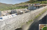
And here is the destination.
pajares-x.webp

Hello Fatma,
Please notify us if you would walk again the Salvador followed by the Reconquista (never heard about it)
 
Last edited:
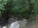
Good work, Gunnar, the map makes sense now. Point "q" looks like where I joined the 4x4 track, you come down a path and hit the wider track and there is a big right hand bend almost straight after that. Not far after going round that bend is a lovely natural spring that the ski champion showed me. There is a little glade on the right hand side of the track surrounded by trees and boulders. There are a couple of pipes coming out of the rocks and the water is wonderful, very cold and very pure (or at least tastes that way).
HPIM2180.webp
 
Hello Thomas,
The fourth path could be the orange dotted path, check the very first map in this topic. But it seems section 3 is to steep, is not really a path.
Meanwhile, feel free to investigate on possible path number 5: follow the blue path to the North
and path 6 by passing "El Nocedo".

Suzanne, a well known Dutch song by VOF De Kunst :-)
 
The one from Galicia (the round) and the one from Castilla & Leon. Individually numbered and made by the same people that make the ones you see on your walk.
image.webp
Hola all,
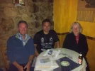
Hope you don't mind me butting, somewhat late, into this discussion? Reading it all, am still confused! This is a photo of us with Ender, who must have spent an hour, using google maps on his phone, trying to explain the route, and the whereabouts of the camino! Very patient guy....!
So, when we got to the Parador, we could see the path, but as I've already said, it was full of cows, and there were calves as well, and I didn't like the way one of the cows walked towards us and started eyeballing us. John walked off down the hill, trying to find a route, and couldn't. So in the end we bottled out and walked the 500 kms on the road until the left hand turn onto the camino. On a bright, sunny Saturday , it wasn't too bad....
Am loving this discussion! Would walk the Salvador again in a heartbeat.
Helen
 
...and ship it to Santiago for storage. You pick it up once in Santiago. Service offered by Casa Ivar (we use DHL for transportation).
:) you walked 500km on the road?
Waauw, there seems to be a seventh path... :)

How stupid of me!! I meant 500 metres of course! :oops: Helen
 
Hello Laurie,

Is autovia maybe the name of a place? Because, there is no autovia - a track where cars can ride 120km/h on separate lanes - in the area.
The name of the bar that should be 200m before the agglomeration sign "Pajares" is "Meson El

t)

Gunnar, I should have said autopista -- your map of Oct. 14 shows it. If you guys remember walking on a dirt path wide enough for vehicles, that was part of the path, I believe, that goes from the N630 (at the bar 200 m before entering Pajares) and the autopista. I don't think it's important to identify where it is, but it would help to show how the two versions of the camino differ and where they converge, I think.

Sorry about the confusion.
 
Hello Laurie,
Well here is in detail how the camino should be starting from "u", also known as the "no thanks"-point, till Pajares without touching the N630. "x" should be the place where the coffin would arrive.
)

Wonderful, how did you do that? So does this mean that the entire mystery of the path between Puerto de Pajares and Pajares pueblo is now solved?! Maybe this will earn you a plenary indulgence from the Salvador. Thanks, Gunnar, but I am going to miss these discussions. Laurie
 
3rd Edition. More content, training & pack guides avoid common mistakes, bed bugs etc
Wonderful, how did you do that? So does this mean that the entire mystery of the path between Puerto de Pajares and Pajares pueblo is now solved?! Maybe this will earn you a plenary indulgence from the Salvador. Thanks, Gunnar, but I am going to miss these discussions. Laurie

Surely there must be other mystery sections of the Salvador?
 
Wonderful, how did you do that? So does this mean that the entire mystery of the path between Puerto de Pajares and Pajares pueblo is now solved?! Maybe this will earn you a plenary indulgence from the Salvador. Thanks, Gunnar, but I am going to miss these discussions. Laurie

Huh? Who said that the entire mystery was solved?
We have not finished path 4-6 yet.
Am hoping its not you who are in the coffin, Laurie?:(
 
Holoholo automatically captures your footpaths, places, photos, and journals.
No, this is not the end! We need to find more roads because Helen reported a very serious problem! Calves are born! In a few months, they will learn how to block our caminos. We need to be prepared.
Tomorrow or maybe later, I will come back with another short alternative to be tested by one of us in her of his next mission if possible.
Till soon.
pajares-red-white-gate.webp
 
Stuart:

Your picture of a natural spring???? If you look to the left there is a trickle of water coming down the slope. When I passed there this spring, it was a raging water fall. It overwhelmed the drainage pipes. I would be cautious of drinking water from here. Especially with all the cattle and wildlife.

Gunnar:

The U>Q>X>B>C is definitely the route I walked in April

Joe
 
Dear Staff Members of PdPF,

I updated our knowledge on a screenshot of Bing Maps which offers more details than Google Maps in our dedicated sector.
I learnt that in fact between point 4 and the old parador, there are 2 railroad sections.
It seems that the School Kids Path stays parallel with the N630.

***UPDATE*** you can see on this map that there is also a path between the bar and the blue path, call it a shortcut. Just before the building of the bar, it's easy to reach this shortcut (check google streetview). But it's possible you have to go through a barbered wire, so it's better to go back to the silo.

View attachment 6390

So, Gunnar, what about the orange dots with the question mark?

And am I right that Fatma and I no longer need to be hypnotized because you have figured out the rest of the old route (meaning the route we used before Ender marked the "coffin route.")?
 
Ideal sleeping bag liner whether we want to add a thermal plus to our bag, or if we want to use it alone to sleep in shelters or hostels. Thanks to its mummy shape, it adapts perfectly to our body.

€46,-
Gunnar,

your last map has attracted all my interest...
I would like to study what is (not visible) at the left.
Because did I walk as it was marked (so at the no thanks point, taking the left path?)
Or might there be another path coming from the Puerta direction and reaching Pajares at the point q?

Because (Laurie, I am sorry I need more hypnosis) the picture and point 9 don't tell me anything...

(But, dear PdP-friends, as I said already : thanks to this and to you, I really would like to go back there again...)

Hi, Fatma,
I THINK that when we walked the "original route", we went on the pink route. (as seen on Gunnar's map posted on Monday at 6:29 pm) At point 7 is where the conch shell is that I photographed, splitting the route between San Miguel and Pajares. The yellow route is Ender's new shortcut, marked with a wooden post and two arrows, one towards albergue (Pajares) and the other towards San Miguel (in other words that is the same split we found a few kms further on). When we walked, that yellow route wasn't there, so we had a few extra kms.

And Gunnar's post of the map from 8:51 today shows the route after the pink and yellow paths merge, all the way into Pajares.

But I am pretty sure that the only differencesbetween walking in 2009 and walking in 2012 were: (1) Ender put up the shortcut coffin route marker and (2) Ender put the arrows on the "dangerous route" in front of the parador. So you probably didn't see that alternative either.

And yes, the only answer here is that we all need to return to the Salvador, the sooner the better. And hope that our incessant postings about the route will not entice hundreds of other forum members to walk the Salvador and crowd it up. Of course, if they think that the average pilgrim on the Salvador is as nutty as we are, they will probably be dissuaded from going.
 
Stuart:

Your picture of a natural spring???? If you look to the left there is a trickle of water coming down the slope. When I passed there this spring, it was a raging water fall. It overwhelmed the drainage pipes. I would be cautious of drinking water from here. Especially with all the cattle and wildlife.

Gunnar:

The U>Q>X>B>C is definitely the route I walked in April

Joe

Good advice and I was thinking the same but the ski champion was very insistent that the water was the best around. He may, however, have been chuckling at home that night :)
 
The one from Galicia (the round) and the one from Castilla & Leon. Individually numbered and made by the same people that make the ones you see on your walk.
Hi, Fatma,
I THINK that when we walked the "original route", we went on the pink route. (as seen on Gunnar's map posted on Monday at 6:29 pm) At point 7 is where the conch shell is that I photographed, splitting the route between San Miguel and Pajares. The yellow route is Ender's new shortcut, marked with a wooden post and two arrows, one towards albergue (Pajares) and the other towards San Miguel (in other words that is the same split we found a few kms further on). When we walked, that yellow route wasn't there, so we had a few extra kms.

I half remember that the new Enders shortcut made the walk Puerto de Pajares-Pajares about five km shorter.
I wonder how long it s now?
As I continue to think it was much longer IRL, than on the map. :-/
 
Good advice and I was thinking the same but the ski champion was very insistent that the water was the best around. He may, however, have been chuckling at home that night :)

Si él te dijo que era potable, lo sería, no creo que engañara con eso.
¿Notaste algo raro esa noche?. :):)
 
I don´t live so far away from the place in question, and am quite willing to drive up there to the Puerto and walk this fine new path, I think I understand how it all hooks up. But I need someone to take the car down to Pajares pueblo and meet me there. Because I will NOT walk back up!

Anyone who wants to explore this can stay at my place down on the plains and drive up with me to do the look-see. Name your date.
 
The 2024 Camino guides will be coming out little by little. Here is a collection of the ones that are out so far.
Hi, Fatma,
I THINK that when we walked the "original route", we went on the pink route. (as seen on Gunnar's map posted on Monday at 6:29 pm) At point 7 is where the conch shell is that I photographed, splitting the route between San Miguel and Pajares. The yellow route is Ender's new shortcut, marked with a wooden post and two arrows, one towards albergue (Pajares) and the other towards San Miguel (in other words that is the same split we found a few kms further on). When we walked, that yellow route wasn't there, so we had a few extra kms.

And Gunnar's post of the map from 8:51 today shows the route after the pink and yellow paths merge, all the way into Pajares.

But I am pretty sure that the only differencesbetween walking in 2009 and walking in 2012 were: (1) Ender put up the shortcut coffin route marker and (2) Ender put the arrows on the "dangerous route" in front of the parador. So you probably didn't see that alternative either.

And yes, the only answer here is that we all need to return to the Salvador, the sooner the better. And hope that our incessant postings about the route will not entice hundreds of other forum members to walk the Salvador and crowd it up. Of course, if they think that the average pilgrim on the Salvador is as nutty as we are, they will probably be dissuaded from going.

I completely agree with the pink way on the map of monday 6:29 being the original way we walked; but it doesn't continue till Pajares - and the last map and picture gave me some new hope about the end of the original path - because I am still very convinced that I did not go back to the N630 before Pajares. That's why I had by seing the last map the very small hope there might be pathes we did oversee before.
Nothing to do with reason, only intuition...

@ Rebekah : tempting proposal, but should I come now, I'd rather walk with you, I am afraid... A pity, that small Europe is not a little smaller. For some things, it would be simply great.

1 basecamp PdPf to explore all the possibilities
2 taxitour Rebekah
3 PdPf-camino-catering-stops for all thursty and hungry new pilgrims on this camino
 
Last edited:
...and ship it to Santiago for storage. You pick it up once in Santiago. Service offered by Casa Ivar (we use DHL for transportation).
Hi, Fatma,
I THINK that when we walked the "original route", we went on the pink route. (as seen on Gunnar's map posted on Monday at 6:29 pm) At point 7 is where the conch shell is that I photographed, splitting the route between San Miguel and Pajares. The yellow route is Ender's new shortcut, marked with a wooden post and two arrows, one towards albergue (Pajares) and the other towards San Miguel (in other words that is the same split we found a few kms further on). When we walked, that yellow route wasn't there, so we had a few extra kms.

And Gunnar's post of the map from 8:51 today shows the route after the pink and yellow paths merge, all the way into Pajares.

But I am pretty sure that the only differencesbetween walking in 2009 and walking in 2012 were: (1) Ender put up the shortcut coffin route marker and (2) Ender put the arrows on the "dangerous route" in front of the parador. So you probably didn't see that alternative either.

And yes, the only answer here is that we all need to return to the Salvador, the sooner the better. And hope that our incessant postings about the route will not entice hundreds of other forum members to walk the Salvador and crowd it up. Of course, if they think that the average pilgrim on the Salvador is as nutty as we are, they will probably be dissuaded from going.


This thread is a lovely example of what makes the San Salvador so appealing to a small number of people. It is really quite challenging, geographically (steep) and zoologically (cows), and sometimes automotively (a mountain highway full of speeding camiones) and meteorologically. The waymarks are sometimes tricky. The maps are being revised, and are hard or impossible to figure out in advance.
In short, you don´t know just what you are in for. There´s an enticing element of actual danger involved, but not insane, Everest-level danger. (There are a couple of bars, after all!) You have to be pretty fit, and you have to do it when the weather is good. You have to be sensible and prepared and very flexible.
It is NOT for everybody. And for those of us who enjoy nature, solitude, and a frisson of risk, that is a wonderful thing indeed.
 
Good morning!

2. I want to find out a good place for a base camp. Where one can stay if one wants to walk all options from Puerto de Pajares to Pajares. There's got to be small pensions etc in other places than Pajares, in the area?
:)

Susanna, I think Pajares or Campomanes is about all there is. Anyway, Pajares would be a good base as one of the end points, or you could break into the parador and set up camp there.
 
This thread is a lovely example of what makes the San Salvador so appealing to a small number of people. It is really quite challenging, geographically (steep) and zoologically (cows), and sometimes automotively (a mountain highway full of speeding camiones) and meteorologically. The waymarks are sometimes tricky. The maps are being revised, and are hard or impossible to figure out in advance.
In short, you don´t know just what you are in for. There´s an enticing element of actual danger involved, but not insane, Everest-level danger. (There are a couple of bars, after all!) You have to be pretty fit, and you have to do it when the weather is good. You have to be sensible and prepared and very flexible.
It is NOT for everybody. And for those of us who enjoy nature, solitude, and a frisson of risk, that is a wonderful thing indeed.

You've really summed up for me everything I liked about the San Salvador. Great post.
 
Holoholo automatically captures your footpaths, places, photos, and journals.
Reb if I had read your very descriptive post a few months ago I would have certainly decided it was not a good fit with kids;-) But you said we'd make it so I'll believe you! Indeed, it's the slight element of actual risk that is enticing (and the scenery beckons - I have not admitted this elsewhere, but we found the scenery from Astorga to Santiago in September pretty underwhelming. Not green, but not autumnal. A few hills, but smaller than where we live. We are blessed to be in NZ and have amazing vistas wherever we go, so our little camino walk was a bit of a disappointment on that front - absolutely wonderful on other levels though. I have high hopes for the Salvador and will be looking out for otters.)
I've almost summoned up the courage to go back and look at the maps above.
Just preparing my coffin first.
 
Ideal sleeping bag liner whether we want to add a thermal plus to our bag, or if we want to use it alone to sleep in shelters or hostels. Thanks to its mummy shape, it adapts perfectly to our body.

€46,-
Reb if I had read your very descriptive post a few months ago I would have certainly decided it was not a good fit with kids;-) But you said we'd make it so I'll believe you! Indeed, it's the slight element of actual risk that is enticing (and the scenery beckons - I have not admitted this elsewhere, but we found the scenery from Astorga to Santiago in September pretty underwhelming. Not green, but not autumnal. A few hills, but smaller than where we live. We are blessed to be in NZ and have amazing vistas wherever we go, so our little camino walk was a bit of a disappointment on that front - absolutely wonderful on other levels though. I have high hopes for the Salvador and will be looking out for otters.)
I've almost summoned up the courage to go back and look at the maps above.
Just preparing my coffin first.

Rachel, of COURSE you will make it. This is a camino, after all. No technical equipment required, just basic fitness, good sense, and I would say, hiking poles. And it is beautiful, oh it is really beautiful. For me, there were moments between Poladura and Arbas and also between Buiza and Poladura when I just looked around me and screamed with joy to be alive. I'm not a touchy-feely kind of person, but if those stretches don't elicit a sense of joy and wonder, nothing else will.

And despite all of our obsessing about pink route and yellow route and point q and point u, when you are walking it you will go from arrow to arrow or conch shell to conch shell and you will find your way and you will love every single minute of it. And as you walk on paths where people for centuries have carried their coffins, you will be grateful that you're not in one yet and you will give thanks and be in the moment.

And my bet is that Gunnar, mapmaker that he is, is going to produce a brilliant comprehensive map that will incorporate all our many hours and days of musing and obsessing and trying to remember. But even if he doesn't, you will be fine without it. Buen camino, Laurie
 
Hello Laurie and Fatma,
How did you guess about the map?
Yes, yesterday evening I was thinking how the lay out needs to be.
But give me some time, I will make a clear map between Arbas and Pajares.

Susanna,
Yes, I stayed at Posada Real. A very nice place with all comfort, except internet. But for internet, you can go to the albergue and ask if you can use the PC for a while. If you choose to go there for a week, let ship groceries to the place so you can use all the comfort of the kitchen.
It's off course more expensive then the albergue.

Meanwhile, I'm still editing the video.
To give you an idea how quick it goes: from the old Parador to Pajares pueblo, it's 4 minutes movie where I worked 4 hours on it last week. And it still needs to be translated to English using subtitles.

I will come back with another short possibility using the red/white gate (last picture). Did anyone see this gate?
 
Fatma,
Your camino was like this, I hope I'm right

Check the map I posted on Friday 11/10/2013 12:34 - post #23 (right corner bottom)
Starting at the emergency track
At "4" you came down and followed San Miguel on the map

Check the map I posted on Monday 14/10/2013 7:29 PM - post #72
Now you followed the pink trail clockwise

Check the picture I posted on Sunday 13/10/2013 5:55 PM - post #52
The pink trail ends on the "t"
You walked till "u"

Check the map I posted Wednesday 16/10/2013 9:51 AM - post #108
The second picture is point "u"
You walked on the yellow dots.
 
3rd Edition. More content, training & pack guides avoid common mistakes, bed bugs etc
And as you walk on paths where people for centuries have carried their coffins, you will be grateful that you're not in one yet and you will give thanks and be in the moment.

That was such a wonderful thing to say, Laurie. :)

I actually had to pick up my handkerchief here.
As I, thanks to you, got tea all over my iPad.
 
If you like regular coffee breaks ( and don't have the electric coil! ) , regular snacks and meals, plenty of wi fi, company, are not reasonably fit and are not comfortable with the slight element of risk, this route is definitely not for you.

Kiwifamily , I think you will love it! When are you going?
 
Ideal sleeping bag liner whether we want to add a thermal plus to our bag, or if we want to use it alone to sleep in shelters or hostels. Thanks to its mummy shape, it adapts perfectly to our body.

€46,-
If you like regular coffee breaks ( and don't have the electric coil! ) , regular snacks and meals, plenty of wi fi, company, are not reasonably fit and are not comfortable with the slight element of risk, this route is definitely not for you.

Kiwifamily , I think you will love it! When are you going?

Good observation.:)
It's impossible to walk this route without an electric coil.
 
Hello Laurie and Fatma,
How did you guess about the map?
Yes, yesterday evening I was thinking how the lay out needs to be.
But give me some time, I will make a clear map between Arbas and Pajares.


I will come back with another short possibility using the red/white gate (last picture). Did anyone see this gate?

Gunnar, of course no one is trying to put pressure on the master mapmaker, you take your time and we all wait patiently for the masterpiece to emerge. And I can't wait for the movie! Laurie
 
Fatma,
Your camino was like this, I hope I'm right

Check the map I posted on Friday 11/10/2013 12:34 - post #23 (right corner bottom)
Starting at the emergency track
At "4" you came down and followed San Miguel on the map

Check the map I posted on Monday 14/10/2013 7:29 PM - post #72
Now you followed the pink trail clockwise

Check the picture I posted on Sunday 13/10/2013 5:55 PM - post #52
The pink trail ends on the "t"
You walked till "u"

Check the map I posted Wednesday 16/10/2013 9:51 AM - post #108
The second picture is point "u"
You walked on the yellow dots.

Wow, Gunnar, this post gives new meaning to the phrase "connect the dots." I wonder which part of your brain is missing in my brain?
 
Join the Camino cleanup. Logroño to Burgos May 2025 & Astorga to OCebreiro in June
I wonder which part of your brain is missing in my brain?

At least, I can say: this part is missing in mine too...
Thank you Gunnar for all your efforts.
It must be indeed this one.
(from 2010 till 2013 vegetation has grown, as the cows have moved from the right to the left side of the N630. The world doesn't stand still...)
 
Hello dear peregrinos and -as,
I've made a final map. It's over 3 pages and I sent it to Laurie for final approval. It contains even some pictures of critical points.
As soon the queen of the peregrinas approved it, it will be shared.
Thank you all for your input.
 
Hello dear peregrinos and -as,
I've made a final map. It's over 3 pages and I sent it to Laurie for final approval. It contains even some pictures of critical points.
As soon the queen of the peregrinas approved it, it will be shared.
Thank you all for your input.

I know that the real reason that I got the draft first was because Gunnar knows that if it makes sense to me, then just about anybody can understand it. I think it's amazing, and I've sent it on to Ender to see if he has any comments, so we can expect that there will be a formal unveiling of the new, incredibly improved, map from the Puerto de Pajares to the Pueblo de Pajares.

I know you are all waiting with bated breath, believe me, it will be worth the wait. Laurie
 
...and ship it to Santiago for storage. You pick it up once in Santiago. Service offered by Casa Ivar (we use DHL for transportation).
@angulero y @StuartM

Una cosa es agua potable y otra es agua tratada.
En los montes el agua es potable pero no tratada. Uno puede beber ( yo lo hago a menudo) es riquísima ademas de muy fresca.
El problema suele ser a no estar tratada a las personas no habituadas puede traer consecuencias ( descomposiciones ).
Nota muy importante - no beber el agua de fuentes donde hay ganado.

One thing is drinkable water and another is chlorinated water.
In the mountains the water is drinkable but not chlorinated. You can drink it ( I often do) it´s nice and cool.
The problem arises as the water is not chlorinated people who re not used to it may suffer consequences (diarrhea).
Important note - Do not drink water from springs where there is livestock.

Buen Camino!
 
De fuentes como esta bebe gran parte de los pueblos de alrededor del mío. No es que el agua del grifo sea mala, pero no hay comparación. Esa de la foto concretamente, está en un monte de castaños y eucaliptos. De esa llevo toda la vida bebiendo...

1235193_10202121834270400_1301471732_n_zpsa62d1fe5.jpg
 
€2,-/day will present your project to thousands of visitors each day. All interested in the Camino de Santiago.

❓How to ask a question

How to post a new question on the Camino Forum.

Featured threads

❓How to ask a question

How to post a new question on the Camino Forum.

Featured threads

Forum Rules

Forum Rules

Camino Updates on YouTube

Camino Conversations

Most downloaded Resources

This site is run by Ivar at

in Santiago de Compostela.
This site participates in the Amazon Affiliate program, designed to provide a means for Ivar to earn fees by linking to Amazon
Official Camino Passport (Credential) | 2024 Camino Guides
Back
Back
Top