Hello all, I have just recently returned from the Primitivo which I finished after doing the San Salvador.
I completed the Salvador in early September '24 so this information may well have changed somewhat especially given changes in weather over the last couple of weeks as we go into Autumn.
To the 'difficult option'! After the village of Llanos De Someron (I believe this is on the stage begining in Pajares) there is an option to take the right hand road down into the valley, the 'easy' way which I believe is all asphalt. You can also go left, taking a dirt track up onto the mountainside, the 'difficult option'. This is about how I found the difficult option.
I am an experienced hiker, particularly in mountains and the weather was looking good. So I naturally took the 'difficult' option. I believe they are both the same distance but this option takes longer due to the terrain with lots of ascending and descending. The route at first is easy. Countouring along the mountainside through sub-alpine vegetation which is overgrown in places, but there is a clear path and spectacular views, at this point it is a steady incline.
Eventually you come to a kind of 'turning' point with drastic steapening of the trail as you turn left, up and over some bluffs, crossing contours instead of following them, before descending into the forest below. At this point (distracted by the beauty) I lost the arrows which are not exactly numerous.
My problem was that a few nights before (I discovered later that evening from another pilgrim) heavy weather had come through and blown out much of this upper section of trail. I believe there was once a chain up here but there is none now, a few metal stairs instead but very worn, be prepared to get your hands on rock and do a little bit of scrambling. As well as the condition of the trail and the lack of arrows, mountain goats had made significant paths in the trees above the bluffs. One of these I followed for around 20 minutes, getting steeper and steeper through denser vegetation. I left my rucksack (very hard to move up there with it on) and proceeded without it to get the lay of the land ahead and found myself at the top looking right down to the valley floor. The Way it was not.... Descending again, using trees as anchors, I found the last recogniseable point and after some searching found a buried arrow pointing in the other direction.
Now the goat paths looked the same as the contour trail and with few arrows it made sense to use them. They also, to begin with, followed the true direction of the route according to my prior research. After discovering my mistake, and finding the arrow, I tried my best to block off the goat paths with branches and make new arrows with branches and rocks while also cleaning up the existing one.
Further on (towards the end of the diversion), near the bottom before you again join up with the village below and the road, there are only 1 or 2 arrows. Again here I took a wrong turn. The Way is not clear at all but I was lucky enough to run into a shepherd who I was able to ask for directions. In the village there is a fountain to freshen up in.
So, yes. The top section is difficult and if you're new to hiking, alone and not experienced, or just not feeling confident I would 100 percent take the 'easy' lower road. That being said, despite my mistake in losing the trail, the difficult option is absolutely beautiful and a real treat to walk on. I was alone and felt like I had the mountains all to myself, it remains my favourite day on the Salvador despite making it harder for myself. A great little adventure!
But my warning really is, ask the locals how they think the trail is going to be before heading up AND, really take your time (in the top section) in looking for arrows and the correct route. Don't trust the goats and don't let the beauty distract you from navigation. Otherwise I recommend the 'difficult' option very highly! It is truly a gem on the Salvador.
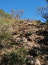
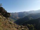
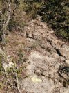
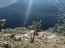
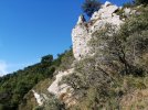
Some pictures attached of the top section for a bit of reference. It is steep but it is beautiful.
I completed the Salvador in early September '24 so this information may well have changed somewhat especially given changes in weather over the last couple of weeks as we go into Autumn.
To the 'difficult option'! After the village of Llanos De Someron (I believe this is on the stage begining in Pajares) there is an option to take the right hand road down into the valley, the 'easy' way which I believe is all asphalt. You can also go left, taking a dirt track up onto the mountainside, the 'difficult option'. This is about how I found the difficult option.
I am an experienced hiker, particularly in mountains and the weather was looking good. So I naturally took the 'difficult' option. I believe they are both the same distance but this option takes longer due to the terrain with lots of ascending and descending. The route at first is easy. Countouring along the mountainside through sub-alpine vegetation which is overgrown in places, but there is a clear path and spectacular views, at this point it is a steady incline.
Eventually you come to a kind of 'turning' point with drastic steapening of the trail as you turn left, up and over some bluffs, crossing contours instead of following them, before descending into the forest below. At this point (distracted by the beauty) I lost the arrows which are not exactly numerous.
My problem was that a few nights before (I discovered later that evening from another pilgrim) heavy weather had come through and blown out much of this upper section of trail. I believe there was once a chain up here but there is none now, a few metal stairs instead but very worn, be prepared to get your hands on rock and do a little bit of scrambling. As well as the condition of the trail and the lack of arrows, mountain goats had made significant paths in the trees above the bluffs. One of these I followed for around 20 minutes, getting steeper and steeper through denser vegetation. I left my rucksack (very hard to move up there with it on) and proceeded without it to get the lay of the land ahead and found myself at the top looking right down to the valley floor. The Way it was not.... Descending again, using trees as anchors, I found the last recogniseable point and after some searching found a buried arrow pointing in the other direction.
Now the goat paths looked the same as the contour trail and with few arrows it made sense to use them. They also, to begin with, followed the true direction of the route according to my prior research. After discovering my mistake, and finding the arrow, I tried my best to block off the goat paths with branches and make new arrows with branches and rocks while also cleaning up the existing one.
Further on (towards the end of the diversion), near the bottom before you again join up with the village below and the road, there are only 1 or 2 arrows. Again here I took a wrong turn. The Way is not clear at all but I was lucky enough to run into a shepherd who I was able to ask for directions. In the village there is a fountain to freshen up in.
So, yes. The top section is difficult and if you're new to hiking, alone and not experienced, or just not feeling confident I would 100 percent take the 'easy' lower road. That being said, despite my mistake in losing the trail, the difficult option is absolutely beautiful and a real treat to walk on. I was alone and felt like I had the mountains all to myself, it remains my favourite day on the Salvador despite making it harder for myself. A great little adventure!
But my warning really is, ask the locals how they think the trail is going to be before heading up AND, really take your time (in the top section) in looking for arrows and the correct route. Don't trust the goats and don't let the beauty distract you from navigation. Otherwise I recommend the 'difficult' option very highly! It is truly a gem on the Salvador.
Some pictures attached of the top section for a bit of reference. It is steep but it is beautiful.