• ⚠️ Emergency contact in Spain - Dial 112 and AlertCops app. More on this here.
  • Remove ads on the forum by becoming a donating member. More here.

Search 74,075 Camino Questions

Which side of the stream did you walk after Armenteira?

Enzed

Active Member
Time of past OR future Camino
Porto to Santiago (2020)
Just curious,

I didn't use an app, just trusted in the arrows and ended up the left side of the stream. Nice walk, nothing too steep, relatively smooth path, made for a relaxing time.
Then after my camino, looking at YouTube videos and blogs and I see images of a different path, on the right side of the stream. One with more rocks, more uneven terrain, closer to the water.

So left or right, which did you end up on?
 
Last edited:
Get a spanish phone number with Airalo. eSim, so no physical SIM card. Easy to use app to add more funds if needed.
Ideal pocket guides for during & after your Camino. Each weighs only 1.4 oz (40g)!
I am interested because I am preparing the costal Caminho.
On this map it seems that you should have the river on left hand first, then on right hand after rua Cabanelas bridge.
 
Are you talking about the Route of Stone and Water? If so, we followed the path on the right. It was stunning.
That I am. Didn't even know there was a right option until later.

On facebook, got me questioning, scenery aside, what is the physically easiest route to walk, comparing my photos and online pictures/youtube, I reckon it'll be the left.
 
I am interested because I am preparing the costal Caminho.
On this map it seems that you should have the river on left hand first, then on right hand after rua Cabanelas bridge.
All I know,, is that somehow some people end up on the right side before merging prior to the bridge. How?, I'm a bit interested too.
 
Ideal pocket guides for during & after your Camino. Each weighs only 1.4 oz (40g)!
The left side, but can't remember why we chose it as it was five years ago.
Edit, I seemed to figure it out by looking at my photos, but it looks like we walked opposite the flow of the river.
 
Last edited:
The 2024 Camino guides will be coming out little by little. Here is a collection of the ones that are out so far.
Right side! Takes you past mill ruins and closer to the water. Path starts right at the road and is fairly obvious and marked. It eventually crosses to the left once the terrain levels out.
 
My photos and videos from that day tell me I walked on the right side. I remember looking across at one point and thinking there might be a path there as well, but could t figure out how to reach it. Something to keep in mind for next time!

IMG_8634.webp
 
Fail to prepare? reduce your risk by buying this book full of practical info.
2nd ed.
A random question, scenery aside, .I'm assuming the left path has easier terrain?
Might be useful info for those pilgrims wanting a less challenging path.

In my very brief research for the route, i may have read that trekking poles were beneficial for sections with large rocks and potentially slippery path. What sections, never saw any of this?
Including the descent into Armenteria, but I did use the road for the last stretch, once again no app.
 
Last edited:
I took the right side too it was one of the most beautifull stretches of the coastal route. I was wondering at the time why so many people left in the dark. The path would be much more difficult and less beautiful in the dark. It starts close to the albergue. Missing the entrance to the path is also very possible, certainly if you are not aware of the existence of this path
 
Train for your next Camino on California's Santa Catalina Island March 30 to April 2
In looking at my many photos of the river, it seems like I walked some of it on both sides. On the mapy.cz it shows a couple of bridges so assume I must have crossed over at some point.
 
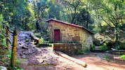
The right side, is how I saw the official waymarks. I was not even aware of the left side, until I figured it out by seeing other walkers (not pilgrims) walking on it. And indeed, you can get closer to the Muiños on the right side. This is important, if you enjoy history and in my opinion, the best part of the route. Here is just one of the many old mills on the right side of the river.

20230919_125511.webp
 
Just curious,

I didn't use an app, just trusted in the arrows and ended up the left side of the stream. Nice walk, nothing too steep, relatively smooth path, made for a relaxing time.
Then after my camino, looking at YouTube videos and blogs and I see images of a different path, on the right side of the stream. One with more rocks, more uneven terrain, closer to the water.

So left or right, which did you end up on?
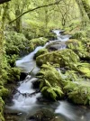
If you stay on the left side you will come across this lovely area.
Just curious,

I didn't use an app, just trusted in the arrows and ended up the left side of the stream. Nice walk, nothing too steep, relatively smooth path, made for a relaxing time.
Then after my camino, looking at YouTube videos and blogs and I see images of a different path, on the right side of the stream. One with more rocks, more uneven terrain, closer to the water.

So left or right, which did you end up on?
 

Attachments

  • IMG_20230512_104528.webp
    IMG_20230512_104528.webp
    973.3 KB · Views: 21
The one from Galicia (the round) and the one from Castilla & Leon. Individually numbered and made by the same people that make the ones you see on your walk.
Just curious,

I didn't use an app, just trusted in the arrows and ended up the left side of the stream. Nice walk, nothing too steep, relatively smooth path, made for a relaxing time.
Then after my camino, looking at YouTube videos and blogs and I see images of a different path, on the right side of the stream. One with more rocks, more uneven terrain, closer to the water.

So left or right, which did you end up on?
Hello We read that the right side was more picturesque- & it was. Can’t be 100%- but possibly on Wise Pilgrim App that mentioned this? Either way- a lovely experience I am sure.
 
Right side, it was one of the most beautiful sections of the Camino... one of the apps/books mentioned taking the right path.
 
Train for your next Camino on California's Santa Catalina Island March 30 to April 2
I just this week walked the route. Take the right side when the first choice occurs. There is a marker with two small arrows stuck on a tree. As the get near the bottom, the path will cross to the left side. A bit further along, the path splits again, and the obvious choice is to cross to the right side. Avoid the temptation and take left side at this point to visit the small village set up.

Just beyond the village, is a small cafe that three weeks ago was doing hand inscribed stamps. This week they had switched to a rubber stamp. If there is a line waiting for service, I would suggest continuing on to the next place.
 
I was pleased to take the right side as advised by John Brierley guide book as it closer to the mills and water and fewer walkers. It is easy to miss where the path divides into left and right banks so most people head straight up the left side.
 
On this map it seems that you should have the river on left hand first, then on right hand after rua Cabanelas bridge.
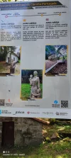
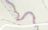
Yes the initial decision is after the green painted S shape on the road and the big info sign - so far so good but then we get to this

mappy1.webp
and there are 2 bridges and 2 sawmills BUT nobody has taken the time to take a Street View Pano or more to show us what it all looks like (until about 30 minutes later when we go right to left)

Notice the bike track is the same (and not the road) so it can't be too uneven??

I have gone for track on the right and it is now active on google
 
Fail to prepare? reduce your risk by buying this book full of practical info.
2nd ed.
Yes the initial decision is after the green painted S shape on the road and the big info sign - so far so good but then we get to this

View attachment 180358
and there are 2 bridges and 2 sawmills BUT nobody has taken the time to take a Street View Pano or more to show us what it all looks like (until about 30 minutes later when we go right to left)

Notice the bike track is the same (and not the road) so it can't be too uneven??

I have gone for track on the right and it is now active on google
Good map, makes it all make sense.

So if you are bothered to research in details the path ahead, stay on the left for smoother easier path or veer right if you want to be close to the water, with some big rocks.

Good knowledge for those with physical limitations, injuries or perhaps pushing a stroller.
 
Last edited:
I was on the right side, as was a large school group (50 kids) of 9-10 year olds, who handled the rocks and tree roots quite well. It wasn't a quiet peaceful day, but the buzz of their excitement added a positive note. (They were fascinated by our mochilas)
 
stay on the left for smoother easier path
It seems there are 2 paths on the left, one is beside the creek/river and other is a road and looks nice for walking on Street View

I would be interested to see a photo at first bridge to see what the yellow arrows (if any) say, and also on that large sign does it warn one of "hunting"? Street View
 
Last edited:
Ideal pocket guides for during & after your Camino. Each weighs only 1.4 oz (40g)!
Train for your next Camino on California's Santa Catalina Island March 30 to April 2
Spain is awash with pilgrims with backpacks so what was so fascinating for these local kids?
These kids did not live on the route of the Frances (or any Camino for that matter). And we had lots of cool patches sewn on our packs.
 
...and ship it to Santiago for storage. You pick it up once in Santiago. Service offered by Casa Ivar (we use DHL for transportation).

❓How to ask a question

How to post a new question on the Camino Forum.

Featured threads

❓How to ask a question

How to post a new question on the Camino Forum.

Forum Rules

Forum Rules

Camino Updates on YouTube

Camino Conversations

Most downloaded Resources

Featured threads

This site is run by Ivar at

in Santiago de Compostela.
This site participates in the Amazon Affiliate program, designed to provide a means for Ivar to earn fees by linking to Amazon
Official Camino Passport (Credential) | 2024 Camino Guides
Back
Top