Search 74,075 Camino Questions

Trail Condition - before Molinaseca

Jack L

New Member
Time of past OR future Camino
Camino Frances from SJPP - September (2017)
Camino Frances from SJPP - September (2021)
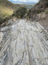
I just finished walking from Cruz de Ferro to Molinasca and I want to warn pilgrims about the trail condition. The trail is really rough with large loose rocks and other hazards. I started in SJPP and this is by far the most difficult section. Take a cab if you have any concerns about your feet or knees.
 

Attachments

  • 383A949E-F1E2-44C8-AEA0-59283A1A4DCB.jpeg
    383A949E-F1E2-44C8-AEA0-59283A1A4DCB.jpeg
    3.3 MB · Views: 8,095
  • 2A6989CE-08E0-4AFA-8987-4B7EE773DB6F.jpeg
    2A6989CE-08E0-4AFA-8987-4B7EE773DB6F.jpeg
    4.4 MB · Views: 531
  • 8E9E1434-B4E9-4A6C-B7CD-1813FBCC7820.jpeg
    8E9E1434-B4E9-4A6C-B7CD-1813FBCC7820.jpeg
    7.2 MB · Views: 518
...and ship it to Santiago for storage. You pick it up once in Santiago. Service offered by Casa Ivar (we use DHL for transportation).
I just finished walking from Cruz de Ferro to Molinasca and I want to warn pilgrims about the trail condition. The trail is really rough with large loose rocks and other hazards. I started in SJPP and this is by far the most difficult section. Take a cab if you have any concerns about your feet or knees.
Wow what a mess.To avoid such hazards you might walk down on the verges of the LE 142 road.
 
Last edited:
The 2024 Camino guides will be coming out little by little. Here is a collection of the ones that are out so far.
I just finished walking from Cruz de Ferro to Molinasca and I want to warn pilgrims about the trail condition. The trail is really rough with large loose rocks and other hazards. I started in SJPP and this is by far the most difficult section. Take a cab if you have any concerns about your feet or knees.
I now walk on the road, its been like that for ages. Rock on rock, so slippery. Thats why I always warn people who plan a long walking leg from Rabanal to Ponferada. On paper it seems fine.
 
Holoholo automatically captures your footpaths, places, photos, and journals.
The hardest part of that section for me was the cyclists flying downhill at high speed, completely out of control, screaming for people to get out of their way. Except there was no place to go. Reminder for cyclists to check their maps and stick to the cycling routes to avoid killing themselves or others. 😳
 
Jack L, I went down that section a few days ago and also thought some should be warned of the "rocks on rocks." I passed a few people who would have benefited from knowing they could have gone down the road.
 
€2,-/day will present your project to thousands of visitors each day. All interested in the Camino de Santiago.
Try walking it in the rain, it is even tougher with slippery boulder
And throw in some freezing rain and some really gusty winds to get the full effect!!!

It’s been that way as long as I’ve been walking
I agree. There is a road as Susan says. Walking in late fall or winter there are hardly any cars at all. Can't say about summer or early fall but I doubt if there would be alot.
 
Done it by road and rocky track in past.found road less physical and safer as it's easy to fall over and break a.bone etc especially when wet
 
That section was exactly like that when I walked in 2010. Incidentally I too walked it yesterday and slept in Molinaseca. I chose to walk on the road after several hours and when a cab was coming I hailed it. He returned to pick me up in fifteen minutes. In 2010 I made it to Acebo and then grabbed a cab. This time I was about a mile from El Acebo. He took me directly to Molinaseca.
 
Get a spanish phone number with Airalo. eSim, so no physical SIM card. Easy to use app to add more funds if needed.
I just finished walking from Cruz de Ferro to Molinasca and I want to warn pilgrims about the trail condition. The trail is really rough with large loose rocks and other hazards. I started in SJPP and this is by far the most difficult section. Take a cab if you have any concerns about your feet or knees.
Plenty of similar days to come. Some somewhat more challenging.

Be careful of the dust on those large smooth rocks. Can be like stepping on black ice.

The climb to O’Cebriero can also be a test.

After that it’s pretty good through to Santiago. Galicia appears to have invested heavily in the development of the CF paths. Which makes sense when you encounter the numbers joining in Sarría.

Buen Camino and stay safe.
 
I just finished walking from Cruz de Ferro to Molinasca and I want to warn pilgrims about the trail condition. The trail is really rough with large loose rocks and other hazards. I started in SJPP and this is by far the most difficult section. Take a cab if you have any concerns about your feet or knees.
We are currently on the Camino Frances. Could someone narrow down the part of the trail that’s bad? We would rather take the road to avoid an injury, but could you narrow down the part of the trail that should be avoided because it’s quite a ways to Molinasca. Thank you! We love this Forum !
 
Ideal sleeping bag liner whether we want to add a thermal plus to our bag, or if we want to use it alone to sleep in shelters or hostels. Thanks to its mummy shape, it adapts perfectly to our body.

€46,-
It’s rocky coming down into El Acebo but doable. The path after Reigo de Ambros is where the pictures were taken. It’s not easy to find the road but it traverses through the mountains and is actually beautiful. Look at a map or ask a local how to find the road.
Last year when I walked the rocky section, a bicycle wiped out and slide into two elderly pilgrims. So if you are biking, it is especially important you find the road.
 
We are currently on the Camino Frances. Could someone narrow down the part of the trail that’s bad? We would rather take the road to avoid an injury, but could you narrow down the part of the trail that should be avoided because it’s quite a ways to Molinasca. Thank you! We love this Forum !
Don't have a map but the ONE time I ever got shin splints on the Camino was when my mom and I missed the trail and ended up taking the road down for much of this section. Now I was way heavier, and probably carrying too much weight too... I tolerate the trail these days...
 
We are currently on the Camino Frances. Could someone narrow down the part of the trail that’s bad? We would rather take the road to avoid an injury, but could you narrow down the part of the trail that should be avoided because it’s quite a ways to Molinasca. Thank you! We love this Forum !
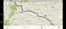
On this map the camino is the black line. Memory is telling me that the bad, rocky section of trail is the part to the north of the highway LE-142. Anyone please correct me if I'm wrong.
Screenshot_20220925-120116.png
 
€2,-/day will present your project to thousands of visitors each day. All interested in the Camino de Santiago.
I just finished walking from Cruz de Ferro to Molinasca and I want to warn pilgrims about the trail condition. The trail is really rough with large loose rocks and other hazards. I started in SJPP and this is by far the most difficult section. Take a cab if you have any concerns about your feet or knees.
I had heard that the stretch down the mountain was incredibly strenuous and my knee was very painful at that point. I had a taxi (arranged the day before) pick me up at the cross to ferry me down the hills. I was very glad afterwards when I heard from some friends how rough it was, especially as they had to walk down in the rain.
 
3rd Edition. More content, training & pack guides avoid common mistakes, bed bugs etc
I just finished walking from Cruz de Ferro to Molinasca and I want to warn pilgrims about the trail condition. The trail is really rough with large loose rocks and other hazards. I started in SJPP and this is by far the most difficult section. Take a cab if you have any concerns about your feet or knees.
Same condition in 2017. Be careful.
 
Those rocks have been there for a LONG time!
I seem to remember reading somewhere that the bed of rock was deliberately placed there to control erosion or similar. Walked through it in 2014 and half-way down, thought how stupid of me not to have turned around and looked for another route, or even returned to the bar/cafe a short distance from the start of the descent and asked them about another route. It was truly treacherous, but I came away unscathed!
 
I remember thinking on my first Camino in 2014 - please God, get me off this mountain in one piece!
you are so right , I walked that part of the Camino (May 25/26) this year,( stayed night at Foncebadon/… Foncebadon to Ponaferrda ) yes those rocks are there for eternity, likely to to stay put for a very long time too,. But it was pure torture to climb from Rabanal del Camino to Cruz de Ferro. Prayed lot more than usual, mostly to St James for strength to get through it. 😂 We all went through that stage . Now it is nothing but pleasant memories. Cheers to all ! Buen Camino .
 
Last edited:
Holoholo automatically captures your footpaths, places, photos, and journals.
I just finished walking from Cruz de Ferro to Molinasca and I want to warn pilgrims about the trail condition. The trail is really rough with large loose rocks and other hazards. I started in SJPP and this is by far the most difficult section. Take a cab if you have any concerns about your feet or knees.
Hi Jack, I also posted a warning on facebook about this stage. Its a great hike but the descent is dangerous. Theres no harm warning people. Im finishing my Camino in Santiago tomorrow. Buen Camino.
 
I just finished walking from Cruz de Ferro to Molinasca and I want to warn pilgrims about the trail condition. The trail is really rough with large loose rocks and other hazards. I started in SJPP and this is by far the most difficult section. Take a cab if you have any concerns about your feet or knees.
Thank you so much for the heads up. Heading there in a couple of weeks, with a knee injury already.
 
The climb to O’Cebriero can also be a test.
IMHO the descent of the topic is the nastiest on the whole Camino Frances. I've heard (and lived through) Zubiri, Alto Perdon and even Triacastella). Somehow hoever tough it was (and it was tough) O'Cebreiro was "sorta fine" for me.... perhaps getting out early enough and taking my time did the trick.... this however was just plain UGLY!!!!
The "funny" (if you will) thing of it was that me and another lady from US were in the bar in El Acebo where 3 other ladies from US called a cab to take them to Ponferrada. Everyone around was talking about that 1st part of descent (from Manjarin) and how bad it was....
The 3 ladies were gracious enough to offer both of us a ride to Molinaseca... but then someone quipped that "oh its not so bad from here on" (IIRC - i believe they said that the trail is still steep but the rocks are no longer there)... of course we believed it and respectfully declined the offered ride
stupid iz as stupid doz ;)
Oh well... something to remember and a story to tell
 
3rd Edition. More content, training & pack guides avoid common mistakes, bed bugs etc
I knew I was no longer a spry young man when I started to notice the downhill sections were actually more challenging than the uphill ones. I always wear Patella straps these days. But still, in that section I prefer the trail to the road... because of the varied terrain. I think that limits "repetitive" injuries. I could be totally wrong.
 
The first edition came out in 2003 and has become the go-to-guide for many pilgrims over the years. It is shipping with a Pilgrim Passport (Credential) from the cathedral in Santiago de Compostela.
I did this stretch in June this year. It's challenging in places but if you've walked from Le Puy it's no biggie. I found the heat more of a problem.
 
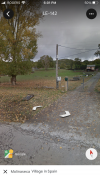
Not long after Riego, the camino crosses from the south side to the north side of the paved road.

This is the view to the right just before the trail diverges:

1664230078025.png

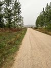
This is the view as the trail splits:

1664230234289.png

I’ve walked that rocky piece of hell twice. My third camino, I walked the road and rejoiced; the road was still scenic and traffic was minimal (be alert, especially at the hairpin curves.)
 
Last edited:
The 2024 Camino guides will be coming out little by little. Here is a collection of the ones that are out so far.
Not long after Riego, the camino crosses from the south side to the north side of the paved road.

This is the view to the right just before the trail diverges:

View attachment 133652

This is the view as the trail splits:

View attachment 133653

I’ve walked that rocky piece of hell twice. My third camino, I walked the road and rejoiced; the road was still scenic and traffic was minimal (be alert, especially at the hairpin curves.)
Our last Camino we took the road for a change and can echo NL's comment on the road and bends. I was so concerned about being visible to drivers that I tied a bright red buff to a hiking pole and held it aloft as an alert to drivers. I think if its dry next time we'll revert to the rocks. If wet we'll stay in the bar!
 
The hardest part of that section for me was the cyclists flying downhill at high speed, completely out of control, screaming for people to get out of their way. Except there was no place to go. Reminder for cyclists to check their maps and stick to the cycling routes to avoid killing themselves or others. 😳
Most difficult thing of the whole camino experience was dealing with cyclists who displayed no courtsey for walkers, some of whom are retirees with limited ability "to get out of the way" quickly for them! I know nothing this board can do, but judging from many complaints I've heard regarding certain sections, if I could, I would be voting for "rules" for cyclists to follow for certain sections and imposing fines for those who feel otherwise entitled. And yes, there have been deaths of walkers due to bikers. Walkers likewise shouldn't be on narrow shoulders of busy roads when there are other alternatives.
 
You can just follow the road it takes you to Molinaseca (although it's a little longer). As other people have pointed out, it looks the same as it always has and many thousands of people walk it every year.
 
Get a spanish phone number with Airalo. eSim, so no physical SIM card. Easy to use app to add more funds if needed.
Actually, the distance may be longer, but I walked the road faster than the trail. At the split point, three Dutch ladies headed off on the trail and I headed down the road. Usually they were a lot faster than me, but that time I was sitting outside a cafe in Molinaseca having a coffee when they came in.
 
I just finished walking from Cruz de Ferro to Molinasca and I want to warn pilgrims about the trail condition. The trail is really rough with large loose rocks and other hazards. I started in SJPP and this is by far the most difficult section. Take a cab if you have any concerns about your feet or knees.
Yes, was like that even in 2018. Knee killer for sure. Have to be so careful. Thank you. On the CF now leaving Pamplona for Puenta la Reina. Not looking forward to the descent from Alto del Perdon either if my memory serves me correctly. Yikes! Buen Camino.
 
So I’m in Rabanal tonight and it’s supposed to rain tonight and all day tomorrow. We are supposed to walk the 32 km to Ponferrada tomorrow (can’t change that) and I’m about to lose my big toenail. I plan on walking to Cruz de Ferro for sure, but the wet shale and the wet road both concern me. If I have to take a cab (and I hate that idea) what town comes before the worst part and what town is after? In other words what would be a logical pickup and drop off point?
 
...and ship it to Santiago for storage. You pick it up once in Santiago. Service offered by Casa Ivar (we use DHL for transportation).
I just finished walking from Cruz de Ferro to Molinasca and I want to warn pilgrims about the trail condition. The trail is really rough with large loose rocks and other hazards. I started in SJPP and this is by far the most difficult section. Take a cab if you have any concerns about your feet or knees.
I am a hospice at Acebo, the area right after the louse rocks for the most part ends. It has been what I believe one of the most “Technical” sections on the Frances starting from just past The Cruz to Acebo. It’s been 12 years that I know of, perhaps more.

It is certainly passable but as other sections they all provide a sense of excitement for the Pilgrim.

Be warned and only by pass this section if you really need to. Continue on, and you will be able to add another exciting story for your friends back home.
Peace. Ed
 
So I’m in Rabanal tonight and it’s supposed to rain tonight and all day tomorrow. We are supposed to walk the 32 km to Ponferrada tomorrow (can’t change that) and I’m about to lose my big toenail. I plan on walking to Cruz de Ferro for sure, but the wet shale and the wet road both concern me. If I have to take a cab (and I hate that idea) what town comes before the worst part and what town is after? In other words what would be a logical pickup and drop off point?
The worst part is between Riegos and Molinaseca.

The camino and the road parallel each other all the way from Rabanal to Molinaseca, with multiple places where you can switch from the trail to the road. The road may be longer and you need to watch for traffic, but it is smooth. The descent to Acebo can be rough, so the road from Monjarin is an option.
 
...and ship it to Santiago for storage. You pick it up once in Santiago. Service offered by Casa Ivar (we use DHL for transportation).
I just finished walking from Cruz de Ferro to Molinasca and I want to warn pilgrims about the trail condition. The trail is really rough with large loose rocks and other hazards. I started in SJPP and this is by far the most difficult section. Take a cab if you have any concerns about your feet or knees.
Jack…. Are you back on Camino? This is Christine (Camino 2017) I walked with you and Jeannette. I am currently on the Via Francigena, in Fidenza tonight. Lovely to see your post. Buen Camino
 
Yes, this is how I remember it years ago.
To be honest, most trails where I live are worse ;-)
But still a good idea to heed a warning to those not used to such conditions.
Ditto.
I had heard the stories but thought it wasn't that bad. But I'm used to worse. If you aren't used to rough conditions, just take it slow - and by the time you get to the bottom, you will be. ;)
 
First time down it was 21 years ago almost to the day! There had been heavy rain from Foncebadon onwards but the sun came out as I approached Molinaseca and the smell of the freshly watered wild herbs and plants was incredible - one of my favourite sections of the CF.
 
Ideal sleeping bag liner whether we want to add a thermal plus to our bag, or if we want to use it alone to sleep in shelters or hostels. Thanks to its mummy shape, it adapts perfectly to our body.

€46,-
Wow what a mess.To avoid such hazards you might walk down on the verges of the LE 142 road.
When I walked it in winter there were periodic snowdrifts covering up the rocks. I would break through hit a rock and over I’d go. I fell over so many times that I was too tired to even let fly with a decent curse. The few other pilgrims out all went down the road. There was virtually no traffic

De Colores

Bogong
 
Yep, Toughest part of the CF I reckon. That section below El Acebo.
Last time we broke the journey in El Acebo, so we did that section fresh.
Made it a lot easier.
 
Whilst not wanting to down play the concerns raised, having just completed the CF a couple of days ago, my experience of the paths away from the roads was so much more enjoyable. Yes, some can slow you down. But when you consider the landscapes, I’d opt for the country routes every time.

Slow down, be careful with your step and use your walking staff/poles if you have them.

Most of all take the time to enjoy the surroundings and the people you’re walking with.

I have been blown away with the country side and its variety.

Buen camino
 
A selection of Camino Jewellery
I just finished walking from Cruz de Ferro to Molinasca and I want to warn pilgrims about the trail condition. The trail is really rough with large loose rocks and other hazards. I started in SJPP and this is by far the most difficult section. Take a cab if you have any concerns about your feet or knees.

@Jack L I note you walked the CF from St Jean in 2017 and 2021. So you would have experienced this section before.

Has it noticeably deteriorated? Perhaps rain erosion?
 
Ideal sleeping bag liner whether we want to add a thermal plus to our bag, or if we want to use it alone to sleep in shelters or hostels. Thanks to its mummy shape, it adapts perfectly to our body.

€46,-
I just finished walking from Cruz de Ferro to Molinasca and I want to warn pilgrims about the trail condition. The trail is really rough with large loose rocks and other hazards. I started in SJPP and this is by far the most difficult section. Take a cab if you have any concerns about your feet or knees.
I Think it has been like that for years 🤷🏻‍♀️
 
I'm from Maine where switchbacks don't exist and mountain trails head straight up steep, steep mountains and back the same way. So when my daughter and I hiked the "treacherous" downhill from Zubiri several years ago, we were certain we had missed it. As did my husband who hiked it a few years later. Compared to what we are used to, it was nothing. Same with the downhill from Alto Perdon. That said, how does the steep slope going into Molinasca compare? I am hitting that part later this week and need to make a decision: road vs steep slope. I am older, but so far have no knee issues. My only Camino injury in 2018 was from walking on the hard road surfaces going into Burgos. One of my feet. So I am leery of the road alternative. Comparison??
 
A selection of Camino Jewellery
I'm from Maine where switchbacks don't exist and mountain trails head straight up steep, steep mountains and back the same way. So when my daughter and I hiked the "treacherous" downhill from Zubiri several years ago, we were certain we had missed it. As did my husband who hiked it a few years later. Compared to what we are used to, it was nothing. Same with the downhill from Alto Perdon. That said, how does the steep slope going into Molinasca compare? I am hitting that part later this week and need to make a decision: road vs steep slope. I am older, but so far have no knee issues. My only Camino injury in 2018 was from walking on the hard road surfaces going into Burgos. One of my feet. So I am leery of the road alternative. Comparison??
It's not the steepness, but the trail surface that makes this stretch difficult, especially when it's wet.
See the pictures in the first post on this thread.
 
I'm from Maine where switchbacks don't exist and mountain trails head straight up steep, steep mountains and back the same way.
It sounds as if you will be fine, at least if it isn't wet. Peg and I have hiked a lot in the White Mountains of New Hampshire and I don't think I've encountered any trail worst than there. Peg really hates going down the bare granite sloping rocks on trails in the Whites (exclamatory remarks can be heard often). I asked her opinion of the descent into Molinaseca and it was "It wasn't so bad" in a sort of Meh tone.

Still, if it goes badly it could be bad indeed. Unlike the soft slabs at home the ones we are talking about are rough and a turn of the ankle could cause the rock to grab your foot while your body decides to go somewhere else. So be careful with your poles to make sure they will not slip; put the tips into little notches of the rocks.

I'll say that there is more fun in remembering surviving going down that path than in actually walking it.
 
Get a spanish phone number with Airalo. eSim, so no physical SIM card. Easy to use app to add more funds if needed.
It just occurred to me that the forum's @John Sikora has a time lapse video on YouTube covering the descent to Molinaseca that includes side graphics that has Xs showing his progress on Brierley's map and Google Earth. I recommend clicking on the title superimposed on the picture below instead of the arrow to make the trail more visible (there is high contrast and the trail is often in shadow).

I watched from minute 16:00 to minute 24:00.

 
It is easy to walk just be careful and positive
So I’m in Rabanal tonight and it’s supposed to rain tonight and all day tomorrow. We are supposed to walk the 32 km to Ponferrada tomorrow (can’t change that) and I’m about to lose my big toenail. I plan on walking to Cruz de Ferro for sure, but the wet shale and the wet road both concern me. If I have to take a cab (and I hate that idea) what town comes before the worst part and what town is after? In other words what would be a logical pickup and drop off point?
From looking at my guidebook, as well as what I remember (from 3 yrs ago), the steep & slippery section is between Manjarin and Molinaseca. It's pretty easy before and after that.
 
So I’m in Rabanal tonight and it’s supposed to rain tonight and all day tomorrow. We are supposed to walk the 32 km to Ponferrada tomorrow (can’t change that) and I’m about to lose my big toenail. I plan on walking to Cruz de Ferro for sure, but the wet TV shale and the wet road both concern me. If I have to take a cab (and I hate that idea) what town comes before the worst part and what town is after? In other words what would be a logical pickup and drop off point?
So I’m in Rabanal tonight and it’s supposed to rain tonight and all day tomorrow. We are supposed to walk the 32 km to Ponferrada tomorrow (can’t change that) and I’m about to lose my big toenail. I plan on walking to Cruz de Ferro for sure, but the wet shale and the wet road both concern me. If I have to take a cab (and I hate that idea) what town comes before the worst part and what town is after? In other words what would be a logical pickup and drop off point?
The worst part starts at Riego de Ambros and ends at Molinaseca. This is where there is solid rock and loose stones, all downhill. It was challenging in places from Acebo but easier to navigate. I was 66 when I did it, arthritic knees, blisters on my toes and no poles but I made it, albeit slowly and carefully. Poles would definitely be helpful in the section between Riego and Molinaseca, and it would be slippery and treacherous in snow or rain. Otherwise perfectly doable.
 
Last edited:
€2,-/day will present your project to thousands of visitors each day. All interested in the Camino de Santiago.
I just finished walking from Cruz de Ferro to Molinasca and I want to warn pilgrims about the trail condition. The trail is really rough with large loose rocks and other hazards. I started in SJPP and this is by far the most difficult section. Take a cab if you have any concerns about your feet or knees.
OR you can walk the road out of El Acebo!
 
It's not the steepness, but the trail surface that makes this stretch difficult, especially when it's wet.
See the pictures in the first post on this thread.
Surfaces on Maine trails range from extremely slippery and rocky to actual boulder climbing. So the surface isn't much of a difference, I think. Slooooow and steady with lots of breaks! I may send my pack ahead. It's the bikes that sound alarming!
 
Actually, the stretch from Alto Altar (about 5k past Cruz de Ferro) TO El Acebo is a longer and MUCH steeper descent than Riego de Ambro to Molinaseca, which starts out steeply (but less so than entry to El Acebo), and flattens quickly. The descent into El Acebo is steep, and the trail is really rutted and chewed up, and seems to have always been thus. Go slow, use your poles, you’ll be fine. Again, cyclists please avoid this piece and take the road, or at least dismount and walk down. Blood-curdling screams at people trying to find the next place to put their foot to avoid breaking an ankle is not welcome or advisable.
 
The focus is on reducing the risk of failure through being well prepared. 2nd ed.
I just finished walking from Cruz de Ferro to Molinasca and I want to warn pilgrims about the trail condition. The trail is really rough with large loose rocks and other hazards. I started in SJPP and this is by far the most difficult section. Take a cab if you have any concerns about your feet or knees.

In 2001, August it was rough.

I found this stage to be one of the toughest days on CF.

Pyrenees difficult, but made sense.

O’Cebreiro difficult, but made sense.

Rabanal to Molinaseca no rhyme or reason whatsoever!
 
It was just a typical trail for me. I was feeling very rough as I left El Acebo as I had a disrupted night and I was struggling to get air into my lungs. For me the downhill was a pleasure with only maybe 100 metres at a particular switchback being noteworthy. As a comparison, my hardest part that day was that small road hill just before Ponferrada. I really struggled up that hill and that was part of the reason that I went looking for medical help the next day.

I guess that we all have different levels of experience but I would not be advising anyone to skip this part of the way.
 
OR you can walk the road out of El Acebo!
Good ol' Google. It noticed that I watched a YouTube video with Molinaseca in it yesterday so this morning it presented me with another. This one involved cyclists taking the road. So, with some of you wondering about the road conditions and traffic, I present:
 
Last edited:
A selection of Camino Jewellery
Good ol' Google. It noticed that I watched a video with Molinaseca in it yesterday so this morning it presented me with another. This one involved cyclists taking the road. So, with some of you wondering about the road conditions and traffic, I present:
Thanks for posting this video, it made interesting viewing ... and I would never have seen it had it not appeared in this thread 😎.

It actually made me call up Google Earth to have a look at the trail that I walked from Cruz de Ferro to El Acebo and Molinaseca. I clearly remember parts of it - from the Cruz de Ferro to El Acebo a stony trail, high temperatures and no shade, and I was cursing myself for wearing my trainers/trail runners instead of my "proper" hiking shoes. After El Acebo one steepish rocky part somewhere which I actually found quite easy and fun to descend but where I thought that it could be slippery when wet and where I was a little surprised how slowly some pilgrims descended and how not at all sure footed they appeared to be. But most of the trail ... I remember it as partly road and partly as a nice and easy to walk nature trail, or does my memory let me down here?

I agree with others who pointed out that how dangerous or difficult a part of the trail of the Camino Frances appears to be depends on a number of factors such as one's own hiking experience on nature trails in hilly and mountainous areas, on the weather of the day, on one's own level of exhaustion and tiredness and similar factors.
 
I just finished walking from Cruz de Ferro to Molinasca and I want to warn pilgrims about the trail condition. The trail is really rough with large loose rocks and other hazards. I started in SJPP and this is by far the most difficult section. Take a cab if you have any concerns about your feet or knees.
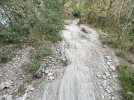
Nothing new about its condition! However it is good to warn folks!
 
The one from Galicia (the round) and the one from Castilla & Leon. Individually numbered and made by the same people that make the ones you see on your walk.
Good ol' Google. It noticed that I watched a YouTube video with Molinaseca in it yesterday so this morning it presented me with another. This one involved cyclists taking the road. So, with some of you wondering about the road conditions and traffic, I present:
I’ve walked the road from El Acebo in late winter and during early Spring. The video doesn’t really give one a visual picture of how steep the curves are on the road. There are a few hair pin turns that can be problematic walking as there is really no extra room on the sides of the road. Sometimes there are boulders that come close to the road as well. IMO the best approach is to be continually alert of what is in front and behind you. Watch for places where you cannot move to-the side and avoid those spots when vehicles are coming. You can’t-always walk against traffic because of the curves would leave you and the car coming toward you in potential blind spots. I prefe this road, however, to the trail down to Molineseca.
 
On my first Camino, I, like everyone else, walked down the trail and thought to myself "Next time I will use the road". The Next time, on leaving El Acebo, I stood on the road and looked at the trail, trying to work out which one I would take. In the end I headed off down the trail. I did exactly the same the next time after that. It turns out that I am one of those stubborn old guys who must walk the whole way, end to end, on the trail, carrying my pack to feel real satisfaction at the zero marker in Finisterre. I think it is actually a Kiwi thing.
 
On my first Camino, I, like everyone else, walked down the trail and thought to myself "Next time I will use the road". The Next time, on leaving El Acebo, I stood on the road and looked at the trail, trying to work out which one I would take. In the end I headed off down the trail. I did exactly the same the next time after that. It turns out that I am one of those stubborn old guys who must walk the whole way, end to end, on the trail, carrying my pack to feel real satisfaction at the zero marker in Finisterre. I think it is actually a Kiwi thing.
More than likely the original trail is now the paved road!
 
Get a spanish phone number with Airalo. eSim, so no physical SIM card. Easy to use app to add more funds if needed.
For those who might be worried about the descent from El Acebo.

I'm a bit of a Camino tragic and publish weekly videos to keep me sane.
(non commercial channel)

Many like this one are 'snippets' from previous Caminos.

It just so happened, the one due for publishing today is.................

The walk down from El Acebo!

It will give you an idea of the path conditions.
(It's from 2018. But it seems from member descriptions to be just the same now)

Turn the sound up. The Birdsong is really something at times.

 
Last edited:
The first time a walked it, it was very difficult. So the second time I decided to stop in El Acebo, and stay at that mega-albergue/hotel. And the next day I walked it with no problem and started to think there was no need to stay in El Acebo. Not realizing I had the opportunity to be well rested, etc. So the third time I was thinking I just go without stopping in El Acebo, and I soon as started along that path, I slipped and felt my groin muscle about to pop. Luckily it didn't. Next time, I will take the road.

Note: This section is at the end of stage for those departing Rabanal del Camino, so one is pretty much tired and such which can easily lead to slips/falls/accidents. So If one does plan to walk this way, I highly recommend staying in El Acebo for the night. Then the next day you are well rested and so it may be easier as I referenced above.

Mark
 
The first time I walked it in 2015, I’d already walked from St Jean. Tbh I dislike heights but just took it slowly and it was ok. It was dry at the time. There was the most beautiful smell of incense from the rock rose.

last year walking with stage 4 cancer I took a cab from El Acebo to Molinaseca and was glad to do so. I found the walk into El Acebo really hard with the shale and the the final steep descent. I did some on the road. I had problem with out of control cyclists on the final v steep zigzag into el Acebo.
 
Get a spanish phone number with Airalo. eSim, so no physical SIM card. Easy to use app to add more funds if needed.

❓How to ask a question

How to post a new question on the Camino Forum.

Most read last week in this forum

Ok so ... this past spring (2024) I decided to walk the "lower" route into Pamplona and became really lost. I just keep thinking about it and it really bugs me. Where did I go astray? At the...
Hi fellow wanderers, I would like a bit of input on this one please. I have finally decided to revisit the Camino Frances next year. I walked SJPDP to Santiago solo in 2016 and walked from...
I asked the tourist office for information about the statue of the pilgrim at the entrance to Carrión de los Condes. Here is their reply. auto-translated: "The Monument to the Pilgrims" is a...
I understand that footwear on the Camino is a personal choice. I will start my first Camino on the Camino Frances in the first part of April. With the varying weather conditions, what...
Hello. Earlier this year I saw photos of the streets being decorated for Corpus christi and I'm thinking that when I do my next camino, probably 2026, that it would be nice to help with the...
Hello, I am looking to continue a segment of the Camino Frances, that I started 10 years ago. I would be starting back up in Burgos. Is it possible to do this in January ? It seems like the...

Featured threads

❓How to ask a question

How to post a new question on the Camino Forum.

Featured threads

Forum Rules

Forum Rules

Camino Updates on YouTube

Camino Conversations

Most downloaded Resources

This site is run by Ivar at

in Santiago de Compostela.
This site participates in the Amazon Affiliate program, designed to provide a means for Ivar to earn fees by linking to Amazon
Official Camino Passport (Credential) | 2024 Camino Guides
Back
Back
Top