Search 69,459 Camino Questions

The exact location оf Campo do Romeiros

AlexKramer

New Member
Time of past OR future Camino
Camino Frances
Hello everyone After the Palas de Rei there is a field called "Campo de Romeiros". This is a field where pilgrims gathered in groups in the Middle Ages to go to Santiago together. Does anyone know the exact coordinates of this field? I found many sources where it (the field) is mentioned, but there is no exact location anywhere.
 
Join Camino Cleanup: Logroño to Burgos May 2025 and Astorga to O'Cebreiro in June.
After the Palas de Rei there is a field called "Campo de Romeiros". This is a field where pilgrims gathered in groups in the Middle Ages to go to Santiago together. Does anyone know the exact coordinates of this field? I found many sources where it (the field) is mentioned, but there is no exact location anywhere.
Putting Campo dos Romeiros into Google Search throws up a number of sources that give the impression that there is an exact point or small area where medieval pilgrims gathered. My hunch is that this is misleading.

I put toponomia campo romeiros palas rei into Google Search and had a look at the first research result, a study or survey of location names in Galicia related to pilgrimage on the Camino de Santiago. The author writes about Romeiro (Galician word) and Romero (castellanized form) that it could also perfectly be the surname of the owner of the land and could have nothing to do with the Camino path. As an example he refers to O Campo dos Romeiros, the name for "some fields in Palas de Rei on the C. Francés".

I understand this to mean that it is just a toponym, a local name for some agricultural area, and not a specific location with a proven historic connection to medieval pilgrims.

I did not look at the other sources in the search result list.

David Gitlitz/Linda Davidson write in their book that the fields just west of Palas, called the Campo dos Romeiros, mark the beginning of the last segment of the 12th-c CC Guide. There is no further information. I guess that later guidebook authors got inspired and imagined this as a place "where pilgrims gathered in groups to go to Santiago together". I severely doubt this as there does not seem to be any evidence for it. I am happy to be corrected of course.
 
3rd Edition. More content, training & pack guides avoid common mistakes, bed bugs etc
Putting Campo dos Romeiros into Google Search throws up a number of sources that give the impression that there is an exact point or small area where medieval pilgrims gathered. My hunch is that this is misleading.

I put toponomia campo romeiros palas rei into Google Search and had a look at the first research result, a study or survey of location names in Galicia related to pilgrimage on the Camino de Santiago. The author writes about Romeiro (Galician word) and Romero (castellanized form) that it could also perfectly be the surname of the owner of the land and could have nothing to do with the Camino path. As an example he refers to O Campo dos Romeiros, the name for "some fields in Palas de Rei on the C. Francés".

I understand this to mean that it is just a toponym, a local name for some agricultural area, and not a specific location with a proven historic connection to medieval pilgrims.

I did not look at the other sources in the search result list.

David Gitlitz/Linda Davidson write in their book that the fields just west of Palas, called the Campo dos Romeiros, mark the beginning of the last segment of the 12th-c CC Guide. There is no further information. I guess that later guidebook authors got inspired and imagined this as a place "where pilgrims gathered in groups to go to Santiago together". I severely doubt this as there does not seem to be any evidence for it. I am happy to be corrected of course.
The most interesting thing is that in all the guidebooks that I have read it is written about this place. Both Elias Valiña and John Brierley and other authors, but no one indicates either the exact location or the source from where this information was taken. Very interesting. They probably just copied everything from each other. I am writing a guidebook myself at the moment and I want to get to the truth. In 10 days I'm going the French way from Astorga, I'll try to get information from the locals.
 
Has anyone tried looking at Domenico Laffi, the 17C italian pilgrim? He has many joucy tidbits, although Galicia seemed to scare him a bit with crosses engraved in stone along the routes which he believed marked spots where bandits had their way with pilgrims. Perhaps not too surprising, after having to spend a night next to a dead pilgrim in O Cebreiro...
 
Transport luggage-passengers.
From airports to SJPP
Luggage from SJPP to Roncevalles
[...] in all the guidebooks that I have read it is written about this place. Both Elias Valiña and John Brierley and other authors, but no one indicates either the exact location or the source from where this information was taken. Very interesting. They probably just copied everything from each other.
Alas, yes, that's the way it is.

I am writing a guidebook myself at the moment and I want to get to the truth. In 10 days I'm going the French way from Astorga, I'll try to get information from the locals.
That's the spirit! Please let us know what you can find. My bet is that the area is either still fields / meadows or it has become a built-up area of Palas de Rei.
 
The one from Galicia (the round) and the one from Castilla & Leon. Individually numbered and made by the same people that make the ones you see on your walk.
Meanwhile I can offer this: An extract from a publication from 1962 with an article about the waymarking of the Camino Francés in Galicia at the time (!!!) and an old map:

Text.jpg
This tells us that Palas de Rei starts at km 546,1 and that the Campo dos Romeiros is 350 m further along the same road (i.e. between km 546,4 and km 546,5 ) and that the bridge over the Ruxián river is at km 547,4.

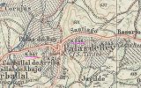
This is a little confusing at first because the road through Palas de Rei is the N-547 and the relevant kilometer markers are km 34 and km 35. However, I found an older map where the road had a different name and the distances are labelled differently:

Map.jpg

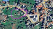
Combine all this information and transfer it to a modern map and one can see that the Campo dos Romeiros is where all the guidebooks say: at the western end of Palas de Rei. It is not clear how large the campo area is supposed to be and where exactly it is supposed to start or end. But perhaps these exact data are simply not known to us and we will never know.

Map PdR.jpg
 
Meanwhile I can offer this: An extract from a publication from 1962 with an article about the waymarking of the Camino Francés in Galicia at the time (!!!) and an old map:

View attachment 175524
This tells us that Palas de Rei starts at km 546,1 and that the Campo dos Romeiros is 350 m further along the same road (i.e. between km 546,4 and km 546,5 ) and that the bridge over the Ruxián river is at km 547,4.

This is a little confusing at first because the road through Palas de Rei is the N-547 and the relevant kilometer markers are km 34 and km 35. However, I found an older map where the road had a different name and the distances are labelled differently:

View attachment 175525

Combine all this information and transfer it to a modern map and one can see that the Campo dos Romeiros is where all the guidebooks say: at the western end of Palas de Rei. It is not clear how large the campo area is supposed to be and where exactly it is supposed to start or end. But perhaps these exact data are simply not known to us and we will never know.

View attachment 175523
Wow, this is already interesting information and really close to the truth. Great job, thanks! Now I will complete this research with another survey of local residents and we will know for sure whether this place existed in the Middle Ages as a gathering place or is it just a name? Well, does its location correspond to what you managed to find in this source?
 
a publication from 1962 with an article about the waymarking of the Camino Francés in Galicia at the time (!!!)
I'd like to clarify that the article uses the word señalización, and I translated it as waymarking, but it is more about identifying, and recreating and fixing, a possible trail of the Camino Francés in 1962 where this work was already ongoing apparently. There is some information about the actors who were involved in this endeavour at the time.

The road through Palas de Rei - now called N-547 - was called carretera general número VI at the time. There were apparently six such general roads, numbered from one to six, and it seems that they all started from Madrid, i.e. the km-numbers indicate the distance from Madrid.

I don't know how this publication materialised on my screen :cool:. It is amazing, the stuff you can find on the internet these days ...
 
Join Camino Cleanup: Logroño to Burgos May 2025 and Astorga to O'Cebreiro in June.
Wow, this is already interesting information and really close to the truth. Great job, thanks! Now I will complete this research with another survey of local residents and we will know for sure whether this place existed in the Middle Ages as a gathering place or is it just a name? Well, does its location correspond to what you managed to find in this source?
I think your research and survey of the local residents is for sure a worthy endeavor, and it can give a lot of information about current beliefs and what has been passed down as fact over the past few generations. But I don't think it can possibly provide certainty as to what was happening where in the Middle Ages.
 
really close to the truth. Great job, thanks! Now I will complete this research with another survey of local residents and we will know for sure whether this place existed in the Middle Ages as a gathering place or is it just a name?
How do you know it is close to the truth? As @David Tallan points out, how will a survey of locals help you "know for sure" what happened in the Middle Ages?

I think this illustrates how guidebooks (and 'local knowledge") develop from maybe a tiny fact, enhanced by a bit of "research", coloured by a lot of speculation, and then given the aura of authority by being set on a page in a book. Then, the author moves swiftly on to the next location and everyone quotes the new truth.
 
As @David Tallan points out, how will a survey of locals help you "know for sure" what happened in the Middle Ages?
Exactly. This is my question too. Folk memory? Frankly, local whimsy and imagination would be my last choice of information about something that happened 700 years ago.
 
The focus is on reducing the risk of failure through being well prepared. 2nd ed.
I think your research and survey of the local residents is for sure a worthy endeavor, and it can give a lot of information about current beliefs and what has been passed down as fact over the past few generations. But I don't think it can possibly provide certainty as to what was happening where in the Middle Ages.
How do you know it is close to the truth? As @David Tallan points out, how will a survey of locals help you "know for sure" what happened in the Middle Ages?

I think this illustrates how guidebooks (and 'local knowledge") develop from maybe a tiny fact, enhanced by a bit of "research", coloured by a lot of speculation, and then given the aura of authority by being set on a page in a book. Then, the author moves swiftly on to the next location and everyone quotes the new truth.
Exactly. This is my question too. Folk memory? Frankly, local whimsy and imagination would be my last choice of information about something that happened 700 years ago.
And I like traditions, legends and folk beliefs - it's all part of the way and I will definitely write about it all in the guidebook. Regarding our particular case - Campo dos Romeiros - here I will apply the wording "according to legend (according to tradition, according to local residents)". I will not write about this as a scientific fact, but I think it is worth mentioning this information. The locals won't help me check if it really happened, they will help me understand where this place, shrouded in legends, is located.
 
Regarding our particular case - Campo dos Romeiros - here I will apply the wording "according to legend (according to tradition, according to local residents)". I will not write about this as a scientific fact, but I think it is worth mentioning this information.
Are you going to mention that the tradition according to which pilgrims gathered in the Campo dos Romeiros is only about 20-30 years old?

I had another look around. Brierly describes the location accurately:
  • From the albergue continue over the N-547 down rua do Peregrino and over the N-547 past monument and field of the pilgrims Campo dos Romeiros [there he repeats the undocumented gathering story line] and onto a path to cross the N-547 past a fountain and back down to the N-547.
And this site belongs to an architect office who realised a project near Palas de Rei a number of years ago. One would think that they may have been in possession of maps of the area:
  • The route of the Camino de Santiago leaves Palas de Rei on the N-547 to turn left along a path paved with slabs, through the Campo dos Romeiros.
I don't recall this paved path leaving Palas de Rei at all but one can see it clearly in Google Street View. The campo is the area to the right and left of this paved path, just as it is described in numerous modern guidebooks and on Camino websites.
 
Romeiro is equivalent to pilgrim but in shorter distances. In romeria del Rocío (Andalucia) pilgrims are called " romeros". In this case maybe the name had to do with a local " romaria".
 
The 2024 Camino guides will be coming out little by little. Here is a collection of the ones that are out so far.

Most read last week in this forum

I hope this is the final stretch! What a day! I’m bone tired and had trouble staying awake writing this, so I hope I’m writing clearly… La Faba to Triacastela, 17.1 miles,27.5 Km. Last night...
Apologies if this isn't the right thread, but I searched the forum and only saw threads about Portugal. I was googling for info about the fires, and Google Maps showed one in Spain. No idea how...
Anyone struggling to find a place in Los arcos 6 km beyond is albergue sansol oasis.I can highly recommend excellent host and food
Hi, We walked the Camino de Santiago for the first time in May & June this year, and absolutely loved it. We plan on walking the first week again in October (with a view to going back later next...
I heard it mentioned that rather than walking through the industrial section of Leon it was possible to take a bus out of the city....but where to?
Hi do any of my pergrino friends have an Amazon watch charger with them I could use to charge my watch up in burgos on the 20th of september.buen camino

❓How to ask a question

How to post a new question on the Camino Forum.

Forum Rules

Forum Rules

Camino Updates on YouTube

Camino Conversations

Most downloaded Resources

This site is run by Ivar at

in Santiago de Compostela.
This site participates in the Amazon Affiliate program, designed to provide a means for Ivar to earn fees by linking to Amazon
Official Camino Passport (Credential) | 2024 Camino Guides
Back
Top