• Remove ads on the forum by becoming a donating member. More here.

Search 74,075 Camino Questions

Question about side paths and trespassing laws? (+mapping fun)

howlsthunder

Active Member
Time of past OR future Camino
Camino Francés (2018)
Camino Francés (2020)
I am from Alaska where the question of "am I trespassing" is a very important one because private, state, federal, native/indian, and public lands are very much jumbled and you sometimes have to really do your homework to be sure you are not accidentally trespassing on property you shouldn't be on. (For example, there is a popular hiking trail that follows an abandoned railway bed along a river in my town. It's completely fine to walk along, but when arriving at "the end", to get back to the highway you are technically trespassing across a bit of tribal and then private land. Most people don't know this and that one should technically backtrack down the entire trail after walking it). In contrast, on my visit to the Scottish highlands I was surprised to find out that legally a person could walk or even camp out anywhere they like, so long as they are not damaging crops or disturbing livestock (I'm sure there must be finer details to this).

So I am wondering what the laws are in Spain? Beyond the obvious (NEVER walk in/across fields or pastures and definitely not where there are signs posted to keep out). In particular I'm interested in the following example:

On my Camino I'd notice (either visually or by noting on my Maps.me app) that there might be a road - usually dirt or gravel - that paralleled the Camino very closely. I only ever went on such a road twice; once just outside Molinaseca where the Camino is a paved sidewalk all the way to Ponferrada that I took in attempt to alleviate severe tendon pain that only flared up on pavement, and another one which was some sort of powerline/offroading "road" that swung over to the highest mountain point overlooking Ponferrada that I think may have also been marked in the Brierley map book - I took it to see the view. Another time while descending a mountain I saw that there was a lightly worn footpath that followed under the high voltage power line; at home people are generally fine using "powerline trails" unless they obviously cross someone's property, but though these seemed like it was the "middle of nowhere" I opted to avoid it just in case.

In all but the two noted situations I didn't feel the need to leave the Camino; the times that I would want to would be to avoid pavement but never to "shortcut" (in future Caminos I'm not predicting tendonitis will be as bad an issue as it was this time and if I find out what I did was wrong, I'll definitely not do it again). But I'm curious as to what the laws are anyway? Again, I'm talking about ROADS, dirt or gravel, that parallel the Camino, usually within a dozen feet or so, that have no gates or signage of any kind, and trails beneath power/utility lines in addition.
 
Last edited:
Perfect memento/gift in a presentation box. Engraving available, 25 character max.
Examples:
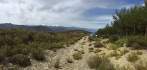
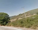
This first one is a road descending the mountain that overlooks Ponferrada. Those trucks belonged to some foresters who were working in the woods:
UNADJUSTEDNONRAW_thumb_3ba6.webp


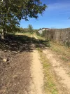
This is the road paralleling the highway leaving Molinaseca. It connects on either end to the highway and is rarely far from the highway itself. It looked like in parts it provides access to orchards though most were quite overgrown (not that that matters):
UNADJUSTEDNONRAW_thumb_3c51.webp

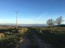
And this was the 'power line trail' that I saw. It seemed to have markers (the white bit?)
UNADJUSTEDNONRAW_thumb_3bfc.webp
 
Examples:
This first one is a road descending the mountain that overlooks Ponferrada. Those trucks belonged to some foresters who were working in the woods:
View attachment 51195


This is the road paralleling the highway leaving Molinaseca. It connects on either end to the highway and is rarely far from the highway itself. It looked like in parts it provides access to orchards though most were quite overgrown (not that that matters):
View attachment 51196

And this was the 'power line trail' that I saw. It seemed to have markers (the white bit?)
View attachment 51197
Wish I had known about the dirt track out of Molinaseca. Looks a lot better than the marked route!
 
Train for your next Camino on California's Santa Catalina Island March 30 to April 2
I don't know the law in Spain but most people are hospitable and if you are on a track and challenged, "Lo siento, soy peregrine y perdido. Puedes ayudarme?" seems to work whether you are or not. Just don't enter an area where hunting is happening or a military area, there are some close to the route. The military will probably help you but it could be unpleasant, although a good story for later in the bar.
 
This is the road paralleling the highway leaving Molinaseca. It connects on either end to the highway and is rarely far from the highway itself. It looked like in parts it provides access to orchards though most were quite overgrown (not that that matters):
View attachment 51196
I am pretty certain that we walked along this path. I was surprised that so many people stayed on the highway leaving Molinaseca. We often try to find alternative routes where available and if memory does not fail me this one actually had a yellow arrow at the very beginning. While we walked along, a tractor passed us who was mowing the overgrowth on one side of the path and we guessed it was because of maintenance for the benefit of camino pilgrims.

I can't answer your general question but have always assumed that trails and roads in Spain are public unless it's obvious that they are on private property or denial of access is clearly marked.
 
The one from Galicia (the round) and the one from Castilla & Leon. Individually numbered and made by the same people that make the ones you see on your walk.
Here are some posted signs that I have seen along my various routes that might help:

"Coto Privado" - Private preserve
"Terrenos Privado" - Private Land
"Bosque Privado" - Private forest
"Propiedad Privada" - Private Property

If I see signs like these, they are usually black letters on a white rectangular background either on a fence, post, or sometimes mounted to a tree.

Then there is the general purpose: "Peligro" = Danger... 'nuff said...

Here is one you need to know, especially in the autumn months...

"Cazadores de Peligros" = Danger Hunters

I have only seen this sign once. But I usually wear a neon colored hat, for just such an eventuality, even in the Spring...

Sometimes, you might see something looking like an international traffic sign, say a walking person with a red circle and a diagonal line through the walker, I simply avoid crossing that 'line.'

If anyone else can contribute some advisory signs that they have seen that are intended to prevent trespassing...no I do not mean no defectar...please do contribute them to this dialog.

Hope this helps.
Yes, if you see a warning including 'privado/a' is better not tresspasing just in case.
'Coto privado' is a private hunting area not available for public hunting. In Galicia is 'Tecor societario'.
In case of hunting 'Peligro cazadores' is the warning of danger.
 
€2,-/day will present your project to thousands of visitors each day. All interested in the Camino de Santiago.
What about "powerline trails" in Spain? It has never occured to me (in Europe) that one could walk along high voltage powerlines, unless, obviously, they follow an already established road. Most of the latter have disappeared, I think, as they are now underground?
 
Last edited:
I can't say that I have noticed them. That does not mean they are not there, only that I have not paid attention.

Anyone got a clue?
 
Thank you very much for everyone's replies. I feel a bit better about my efforts in avoiding pavement! I definitely looked everywhere for signs that said anything related to the land being private or dangerous - luckily many of these sorts of signs have cognates in both English and French (I can't speak French too well any more but I can stumble through reading it okay). I hadn't known about the hunting signs but did see the other forum posts about it; a good reminder about being extra cautious in fall!

I am pretty certain that we walked along this path. I was surprised that so many people stayed on the highway leaving Molinaseca. We often try to find alternative routes where available and if memory does not fail me this one actually had a yellow arrow at the very beginning. While we walked along, a tractor passed us who was mowing the overgrowth on one side of the path and we guessed it was because of maintenance for the benefit of camino pilgrims.

I can't answer your general question but have always assumed that trails and roads in Spain are public unless it's obvious that they are on private property or denial of access is clearly marked.

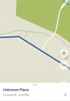
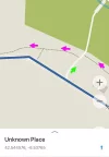
I don't recall seeing any arrows, though I could of missed it. When I noted long stretches of pavement, I'd check my Maps.me maps I downloaded from this forum and look to see if there were side routes. The one outside of Molinaseca looked like this:

IMG_9857.webp
The Camino is the heavy blue line. Main paved roads are white. The dotted brown lines are dirt roads; the dirt tractor road in the photo above is the one in this map screenshot. It was easy to scroll ahead and see that it never stayed far from the Camino and eventually joined back up again, eating up quite a stretch of pavement!
 
Perfect memento/gift in a presentation box. Engraving available, 25 character max.
What about "powerline trails" in Spain? It has never occured to me (in Europe) that one could walk along high voltage powerlines, unless, obviously, they follow an already established road. Most of the latter have disappeared, I think, as they are now underground?

I don't recall seeing them too often. I think once at the start of the Meseta (though they don't follow the Camino and didn't have a path near them and the Camino was gravel so there was no reason to stray) and then descending from El Acebo to Ponferrada, just a bit outside El Acebo is where I took the above photo. Those pylons had a road that turned into a foot path or something with little white markers. The Camino was the shoulder of the road for a ways before becoming a trail and the "power line" trail there would of been another side detour avoiding asphalt and hard rocks.
 
I am Spaniard I don't know precisely the law on that issue. I walk wherever I want if I don't see PROPIEDAD PRIVADA PROHIBIDO EL PASO or a gate that is not possible to open.
This has been my practice. I’ve never had a problem anywhere. The most surprising country was China. In the area that I lived If there was no fence and guard you just walked in. This included factories and construction sites. The only exception is in the United States. My country is a bit weird about private property. And in parts of Mexico and Central America where it’s necessary to find out about the areas where it’s just not prudent to walk.
 
The one outside of Molinaseca looked like this:
View attachment 51255
The Camino is the heavy blue line. Main paved roads are white. The dotted brown lines are dirt roads; the dirt tractor road in the photo above is the one in this map screenshot. It was easy to scroll ahead and see that it never stayed far from the Camino and eventually joined back up again, eating up quite a stretch of pavement!
Yes, I remember this well. I also checked Google Earth and the Brierley guidebook just now. I think most people who just follow yellow arrows miss this or they are not bothered (their loss!). The guidebook says: "Molinaseca - from albergue [last one on the left side at the end of Molinaseca] continue down the main road (or just beyond the tennis court turn off right to track alongside fruit orchards parallel to the road) to top of a rise with Ponferrada visible ahead."

We missed this turn off to the right at the tennis courts but we cut down to the track at the next possibility, see below (track in purple, our way in green). So you actually walked on the "right way" there 🙂. I have always assumed that trails that are marked as dotted brown lines as in this map are open to the public (on foot) in Spain unless there is a clear indication to the contrary.

IMG_9857 add.webp
PS. Same description in Gronze.es: Cruzamos Molinaseca por la calle Real y salimos por la carretera LE-142, hacia Ponferrada. Cien metros más adelante del albergue municipal tomamos una calle a mano derecha.
 
Last edited:
Train for your next Camino on California's Santa Catalina Island March 30 to April 2
Yes, I remember this well. I also checked Google Earth and the Brierley guidebook just now. I think most people who just follow yellow arrows miss this or they are not bothered (their loss!). The guidebook says: "Molinaseca - from albergue [last one on the left side at the end of Molinaseca] continue down the main road (or just beyond the tennis court turn off right to track alongside fruit orchards parallel to the road) to top of a rise with Ponferrada visible ahead."

We missed this turn off to the right at the tennis courts but we cut down to the track at the next possibility, see below (track in purple, our way in green). So you actually walked on the "right way" there 🙂. I have always assumed that trails that are marked as dotted brown lines as in this map are open to the public (on foot) in Spain unless there is a clear indication to the contrary.

Ah-ha! It seems my maps-only version of the Brierley guide does not bother with these things - no mention of this path. I'm thinking that for my second Frances walk I will buy the full guide for my sister, for whom it will be her first Camino, and I'll have to scan it for other tidbits. :)

I noticed the path back a ways but wasn't sure about it but I went the same way you did to get onto it, and then texted my pilgrim friends about it as they were a ways behind me so they'd know to take it (and they did).
 
The Camino was the shoulder of the road for a ways before becoming a trail and the "power line" trail there would of been another side detour avoiding asphalt and hard rocks.
I can't figure out where this was exactly but looking at maps and satellite images of the area, I still think that there are no power line trails in this part of the world as a rule although a high voltage powerline can follow an established road or trail for a while. It has also just occurred to me that what I used to think was a trail under the power lines in these satellite images are actually the wires! Stupid me! 🙂
 
I can't figure out where this was exactly but looking at maps and satellite images of the area, I still think that there are no power line trails in this part of the world as a rule although a high voltage powerline can follow an established road or trail for a while. It has also just occurred to me that what I used to think was a trail under the power lines in these satellite images are actually the wires! Stupid me! 🙂

On the contrary, there are -- I posted a photo of one above:
I don't recall seeing them (utility/power lines) too often.… and then descending from El Acebo to Ponferrada, just a bit outside El Acebo is where I took the above photo. Those pylons had a road that turned into a foot path or something with little white markers. The Camino was the shoulder of the road for a ways before becoming a trail and the "power line" trail there would of been another side detour avoiding asphalt and hard rocks.

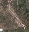
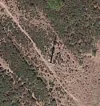
The above started out like a road but quickly turned into a footpath. Here are Google satellite images of this spot:

Screen Shot 2019-01-25 at 5.33.18 PM.webp
My photo at the top was taken from the road, looking down the dirt road that spurs away in the lower right of this satellite image. You can see just beyond the first pole there's kind of a turn-around spot and then it becomes a footpath. Below is an image of a utility pole along what is basically a foot path:

Screen Shot 2019-01-25 at 5.33.36 PM.webp

But like I said, I don't really remember seeing any other trails like this other than in the mountains near El Acebo. Just wondered if any other part of the world (Spain in particular) has trails along their utility poles like we tend to in Alaska. :)
 
The one from Galicia (the round) and the one from Castilla & Leon. Individually numbered and made by the same people that make the ones you see on your walk.
But like I said, I don't really remember seeing any other trails like this other than in the mountains near El Acebo. Just wondered if any other part of the world (Spain in particular) has trails along their utility poles like we tend to in Alaska. :)
I know it's a bit of an idle conversation topic but that's what intrigues me, too. :)
 
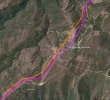
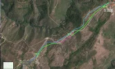
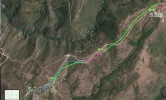
Oh, this is fun 🙃. I think I have identified the place and have tracked that particular powerline for a bit, see first screenshot below (powerline marked in orange, camino path marked in purple) plus another GE screenshot of the same powerline further along the road towards Ponferrada where you can see nothing that resembles a track following it.

The laws on right of access differ from one European country to the next but as far as general hiking is concerned in Continental Europe, I follow my gut feeling, which means the rules I'm used to: if it looks like a road or a path and there is no indication to the contrary, i.e. no sign or barrier and it's not obviously private property, then I use it. I would not do this in the UK, it seems to be different there and I'm very wary of it. I didn't know about the tradition in Scotland that you mentioned earlier. I believe the Nordic countries have rules that are similar to Scotland.

I've started to use Pocket Earth to check on trails. I'm wary of trails that end all of a sudden or peter out eventually.

PW line 1.webp
PW line 2.webp
 
I am Spaniard I don't know precisely the law on that issue. I walk wherever I want if I don't see PROPIEDAD PRIVADA PROHIBIDO EL PASO or a gate that is not possible to open.
These are also my opinion and experience.

This thread reminds to me a book I read some years ago. It tells the experience of a teacher of the town of Ayora (half way between Valencia and Albacete); this man took a map and drew a straight line from his home to Santiago, allowing a narrow tolerance margin of few kilometres on each side, and with his son started that way. They could walk all the previously designed track excepted in one place: their line crossed the area of king's residence! The police did not permit crossing, but kindly transferred them by car from one side to the other of the prohibited area.
 
The 2024 Camino guides will be coming out little by little. Here is a collection of the ones that are out so far.
Concerning use of powerline 'trails' as an adjunct to the Camino, short cuts, or pass throughs, I offer one observation...

In the US and indeed most countries, these powerline rights of way must be kept free of vegetation so as to not interfere with the commercial purpose of transmitting electrical power. Access for maintenance and instant repair must be maintained at all times.

As a consequence, the power utilities use seriously, heavy duty, commercial (not household grade) herbicides to kill off or control most vegetation under these lines. The 'best' of these highly carcinogenic chemicals are persistent in the soil, and on vegetation.

If you walk over it, you can disturb and possibly inhale these dangerous chemicals. Alternatively, they get on your footwear, clothing and other gear. From there, they get to your hands, arms, legs and skin.

One rhetorical question: Why would anyone, knowing this, subject themselves to carcinogenic chemicals...? 'Nuff said.

I avoid these cleared strips, no matter how convenient they appear...

Hope this helps.
 
Last edited:
In the US and indeed most countries, these powerline rights of way must be kept free of vegetation so as to not interfere with the commercial purpose of transmitting electrical power.
This is not the case for EU countries as a rule. They don't use dangerous pesticides that could end up on one's hands and clothes to keep the corridors free of vegetation. Quite the contrary. By way of an example, I just read about a 5-year project (2011-2017) in Belgium and France where the electricity operators manage and restore large areas under medium and high-voltage overhead power lines to increase biodiversity and to restore a more varied vegetation. They dug ponds, planted orchards with now rare local fruit trees or European wild pear, European wild apple and common medlar under overhead power lines. They also created simple flower meadows and areas for pasture and other similar measures.

I personally would not choose to walk under high voltage powerlines but that's because they remind me too strongly of the fact that I'm not in unspoilt nature and I also don't like the humming sound they sometimes produce. We once looked up why this happens but I've forgotten already. Something to do with the weather. I am not going to mention electrosmog. 🤔
 
Last edited:
I am sure the path out of Molinesca is the alternate route described in the Village to Village Guide which I used. The road passes fields and orchards to the right and below the paved road way. As I walked I could hear other pilgrims above me on the road. That route then crosses the road and enters Ponferrada from the backside over the old bridge. A much nicer path IMHO.
 
A selection of Camino Jewellery
Oh, this is fun 🙃. I think I have identified the place and have tracked that particular powerline for a bit, see first screenshot below (powerline marked in orange, camino path marked in purple) plus another GE screenshot of the same powerline further along the road towards Ponferrada where you can see nothing that resembles a track following it.

The laws on right of access differ from one European country to the next but as far as general hiking is concerned in Continental Europe, I follow my gut feeling, which means the rules I'm used to: if it looks like a road or a path and there is no indication to the contrary, i.e. no sign or barrier and it's not obviously private property, then I use it. I would not do this in the UK, it seems to be different there and I'm very wary of it. I didn't know about the tradition in Scotland that you mentioned earlier. I believe the Nordic countries have rules that are similar to Scotland.

I've started to use Pocket Earth to check on trails. I'm wary of trails that end all of a sudden or peter out eventually.

Haha, cool! Yep, that's the same line, but running west out of the next village.

Here's the stretch between El Acebo and Riego de Ambros with green for the powerline, pink for the bit I photographed that started out as a dirt road then turned into a foot track, and then blue for a "Calle Real" that doubled as the Camino. The darker blue is the part I walked on, the light blue is another Calle Real that I didn't know existed before today and now I feel dumb about having walked on the road:
mappy-map.webp

The pathways people make for themselves are interesting to me. I have a graphic design degree but had a class where we learned about human design for public spaces. A landscape architect lived across from a park that had paths at right angles. In the winter, he noticed the paths people made in the snow for themselves; they did not follow the paths under the snow. So he re-designed the park to use the organic (and more direct) paths people chose for themselves. I thought a lot about this when I was on the Camino because historically it's kind of a giant version of this, albeit with strategic reasons for parts of it (avoiding bandits, etc). Roads and powerlines are very different from one another in where they can be built - and then human trails different yet again. It's interesting to me when walking trails are combined with one of the others because often they don't feel as organic as the human-made paths we humans chose for ourselves. And I noticed this in quite a few areas on the Camino where the path was "forced" for some reason versus where it had clearly just been a path it's entire existence. :)

Concerning use of powerline 'trails' as an adjunct to the Camino, short cuts, or pass throughs, I offer one observation...

In the US and indeed most countries, these powerline rights of way must be kept free of vegetation so as to not interfere with the commercial purpose of transmitting electrical power. Access for maintenance and instant repair must be maintained at all times.

As a consequence, the power utilities use seriously, heavy duty, commercial (not household grade) herbicides to kill off or control most vegetation under these lines. The 'best' of these highly carcinogenic chemicals are persistent in the soil, and on vegetation.

Thanks, this is interesting information that I will definitely keep in mind! However, it doesn't apply to the power lines here at home or the one I saw in Spain, where the only vegetation was scrubby mountain plants. Here at home crews keep trees and brush cut down but no chemicals are ever used - likely because the growing season in Alaska is SO incredibly short, things that had future potential to interfere with a utility pole will take well over a decade to grow, not to mention the environmental impact such things would have. In the meantime, if there's a trail under a particular power line (not all have them but many do), the sheer volume of people traveling a lot of these paths on ATVs, horseback, dogteam, and foot tend to trample down any small vegetation so there's not as much for crews to do. Thus power line trails are a commonly used system for residents here. Instead, I worry more about environmental damage of people walking where they don't need to be walking.

At the time, I thought about this a lot because we had all stayed at the Casa del Peregrino, at the end of town. As we left the albergue that morning, we couldn't find the Camino in trail-form so most of us pilgrims followed on the road, figuring that's where we were supposed to go. So when I saw the power line, I wondered if that would of been a safer choice compared to the road, but seeing that it petered into a narrow footpath I decided most pilgrims probably didn't go that way for a reason and kept to the road until the Camino appeared on a Calle Real.

But looking at this satellite image and just now looking at my Camino map apps, I see that we were all mistaken and if we'd backtracked up the road from our albergue, we could of rejoined the Camino on a nice, dirt/gravel Calle Real. :)
 

Attachments

  • mappy-map.webp
    mappy-map.webp
    402.1 KB · Views: 5
I am from Alaska where the question of "am I trespassing" is a very important one because private, state, federal, native/indian, and public lands are very much jumbled and you sometimes have to really do your homework to be sure you are not accidentally trespassing on property you shouldn't be on. (For example, there is a popular hiking trail that follows an abandoned railway bed along a river in my town. It's completely fine to walk along, but when arriving at "the end", to get back to the highway you are technically trespassing across a bit of tribal and then private land. Most people don't know this and that one should technically backtrack down the entire trail after walking it). In contrast, on my visit to the Scottish highlands I was surprised to find out that legally a person could walk or even camp out anywhere they like, so long as they are not damaging crops or disturbing livestock (I'm sure there must be finer details to this).

So I am wondering what the laws are in Spain? Beyond the obvious (NEVER walk in/across fields or pastures and definitely not where there are signs posted to keep out). In particular I'm interested in the following example:

On my Camino I'd notice (either visually or by noting on my Maps.me app) that there might be a road - usually dirt or gravel - that paralleled the Camino very closely. I only ever went on such a road twice; once just outside Molinaseca where the Camino is a paved sidewalk all the way to Ponferrada that I took in attempt to alleviate severe tendon pain that only flared up on pavement, and another one which was some sort of powerline/offroading "road" that swung over to the highest mountain point overlooking Ponferrada that I think may have also been marked in the Brierley map book - I took it to see the view. Another time while descending a mountain I saw that there was a lightly worn footpath that followed under the high voltage power line; at home people are generally fine using "powerline trails" unless they obviously cross someone's property, but though these seemed like it was the "middle of nowhere" I opted to avoid it just in case.

In all but the two noted situations I didn't feel the need to leave the Camino; the times that I would want to would be to avoid pavement but never to "shortcut" (in future Caminos I'm not predicting tendonitis will be as bad an issue as it was this time and if I find out what I did was wrong, I'll definitely not do it again). But I'm curious as to what the laws are anyway? Again, I'm talking about ROADS, dirt or gravel, that parallel the Camino, usually within a dozen feet or so, that have no gates or signage of any kind, and trails beneath power/utility lines in addition.

I'll make it simple... Walk where you please, so long as its not someone's back garden nobody is going to care, all tracks and trails you can walk along, whether its a eucalyptus cut or some farmers track. Just like the Spanish hunters who will go anywhere they like. Check out my current thread for any proof you need, hopefully this will put an end to the question. And I dare anybody to bring up the subject of camping again.
 
The pathways people make for themselves are interesting to me. I have a graphic design degree but had a class where we learned about human design for public spaces. [...] And I noticed this in quite a few areas on the Camino where the path was "forced" for some reason versus where it had clearly just been a path it's entire existence.
Funny that you mention this. At various places at the beginning of the Camino Frances, I stopped and looked around and thought: Why are we walking here? This doesn't feel "normal", it doesn't feel like a trail created by people walking from one place to the next because they needed to get there or needed stuff to carry there. I understand of course that there are a number of reasons why we are made to walk on these artificially - and not very artfully - created trail sections.

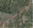
One last thing: I sometimes have a look at Strava heatmaps to see where I could walk. Here's the one for the area we've discussed. The white (high frequency), orange and red (low frequency) lines mark trails walked by people and registered on Strava. If you zoom in (on the website) you can even see that someone did walk the trail under the powerline that you photographed. 🙂

Strava El Acebo.webp
 
Last edited:
€2,-/day will present your project to thousands of visitors each day. All interested in the Camino de Santiago.
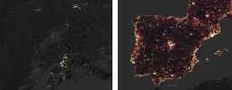
And for comparison and on the same scale, a Strava heatmap for Spain and for parts of Alaska. The bright spots and lines mark places where many people walk (they don't mark street lights). You can even spot one or two caminos.

Strava Alaska Spain.webp
 
A landscape architect lived across from a park that had paths at right angles. In the winter, he noticed the paths people made in the snow for themselves; they did not follow the paths under the snow. So he re-designed the park to use the organic (and more direct) paths people chose for themselves.

Your comment on 'organic paths' triggered a memory of something vaguely related (sorry if I venture a bit off topic). Apparently organic paths designed by a slime mold rival the efficiency of us humans, and the slime mold not only designs a lot quicker, their networks are also more adaptable. After reading the linked article I had mental pictures of the map of Spain with oat flakes where the cities and villages would be. :p
 
Here is one you need to know, especially in the autumn months...

"Cazadores de Peligros" = Danger Hunters

I have only seen this sign once. But I usually wear a neon colored hat, for just such an eventuality, even in the Spring...


Hope this helps.

"Cazadores de Peligros" means, probably, "danger hunters", but the meaning here (and therefore the translation) should be: "Danger , hunters" (the comma is of the essence). To be translated into Spanish as "Peligro, Cazadores" (and you can safely avoid writing the comma if you use two lines in the text").

You'd be a "cazador de peligros" if you are hunting for dangerous situations.

In any case, as it has been mentioned earlier, the only relevant posted sign you want to pay attention to is "PROPIEDAD PRIVADA, PROHIBIDO EL PASO" ("private property, not trespassing").
 
...and ship it to Santiago for storage. You pick it up once in Santiago. Service offered by Casa Ivar (we use DHL for transportation).
I'll make it simple... Walk where you please, so long as its not someone's back garden nobody is going to care, all tracks and trails you can walk along, whether its a eucalyptus cut or some farmers track. Just like the Spanish hunters who will go anywhere they like. Check out my current thread for any proof you need, hopefully this will put an end to the question. And I dare anybody to bring up the subject of camping again.

This is the conclusion I have come to as well; good summary!

And for comparison and on the same scale, a Strava heatmap for Spain and for parts of Alaska. The bright spots and lines mark places where many people walk (they don't mark street lights). You can even spot one or two caminos.

View attachment 51425

THIS IS AMAZING. The river trail I mentioned before where in order to finish you essentially end up trespassing? It clearly shows where most people stop walking and either turn around and go back, cut upstream along the river, or - cross the river and trespass. And surprisingly, most people don't trespass! Glad to hear it. The Camino bits are very interesting as well! I'm going to be spending some time with this. :)

Your comment on 'organic paths' triggered a memory of something vaguely related (sorry if I venture a bit off topic). Apparently organic paths designed by a slime mold rival the efficiency of us humans, and the slime mold not only designs a lot quicker, their networks are also more adaptable. After reading the linked article I had mental pictures of the map of Spain with oat flakes where the cities and villages would be. :p

As I'm the OP and I'm VERY into maps and paths, I heartily approve of your contribution. :D Amazing!
 

❓How to ask a question

How to post a new question on the Camino Forum.

Most read last week in this forum

Hi all .. quiet time of the year, up here in England hunkered down against the winter wolf ... so .. idle thought and based on the dinner guest question. If you could walk on Camino with someone...
Hi all, I am thinking about taking my baby (she will be about 4-5 months) on the camino this spring. I have walked quite a few caminos and I think the Frances or Portuguese would be a good...
Hi everyone! I’m so grateful for this forum. I’ve already learned so much. I’m doing the GR65- Via Podeinsis followed by the Camino francés from August -November of 2025. I have my ticket...
Musings post-Camino: As I continue to process and digest my Camino experience this past summer, I’m struggling trying to understand why this has been such a huge deal for me, and puzzled why for...
Has anyone taken one-to-one Spanish lessons online with Spanish teacher prior to a camino? Did you find you got good value doing it over Zoom versus an in-person Spanish class? I’m wondering if 10...
My wife and I are going to Portugal for a couple of weeks this spring, after which I will meet my brother to walk in Spain for another couple of weeks. My wife has physical limitations and can't...

Forum Zoom Chats

Join our Camino Forum Zoom chats every Tuesday. See the next one here.

❓How to ask a question

How to post a new question on the Camino Forum.

Forum Rules

Forum Rules

Camino Updates on YouTube

Camino Conversations

Most downloaded Resources

This site is run by Ivar at

in Santiago de Compostela.
This site participates in the Amazon Affiliate program, designed to provide a means for Ivar to earn fees by linking to Amazon
Official Camino Passport (Credential) | 2024 Camino Guides
Back
Top