Search 74,075 Camino Questions

LIVE from the Camino Mountain route from Soto de Luiña

LTfit

Veteran Member
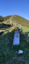
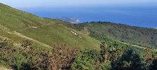
This is a pitch to follow the mountain route from Soto de Luiña😊. The hospitalero in the municipal will discourage you quite profusely (difficult and no services for 19 km) but in good weather and if you are fit I really recommend it.

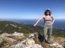
The majority of pilgrims take the coastal route but as I had walked it 5 years ago I decided to go through the mountains. It was no walk in the park with elevation gains of 750 meters and some tricky narrow downhills with loose rocks but if you're fit it is really worthwhile.IMG_20220709_090551.jpgIMG_20220709_091649.jpg
 
Last edited:
Holoholo automatically captures your footpaths, places, photos, and journals.
YAY! I knew you would love it! So many people get the wrong info. It is hard but not dangerous or scary, and the warnings are very ominous. A good friend walked this alternative about a month ago and she kept running into a guy named Pepe, first the night before walking he was working in a bar, then the next morning he was working in a hotel bar where she got coffee, and he kept telling her to avoid it! Luckily she had been forewarned.

Is this Pepe the same person who tried to discourage you? She didn’t stay in the albergue so she wasn’t sure if he was the hospitalero or not.
It was the hospitalero in the Escuelas municipal that discouraged everyone, don't know his name.

I would not suggest the route in bad weather, even today after days without rain it was in parts muddy and wet but the day was so splendid I had no excuse. As far as I know I washe only one who walked it.

Parts reminded me of the Hospitales route on the Primitivo.

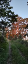
Here is a picture when the sun was coming up. Looks as if the trees are orange.

IMG_20220709_070123.jpg
 
it is a pity people are discouraged to follow that route, like I was discouraged too, it looks amazing!!! The Ballotas route has too much tarmac and non stop ups and downs crossing small valleys among eucaliptus trees, not one of my favourite parts of the Norte. Seeing these photos, I want to go back and take the mountain route, yes!!!
 
A good friend walked this alternative about a month ago and she kept running into a guy named Pepe, first the night before walking he was working in a bar, then the next morning he was working in a hotel bar where she got coffee, and he kept telling her to avoid it! Luckily she had been forewarned.

I think I’m the friend Laurie’s referring to - and yes, Pepe was a chief discourager (and also strangely seemed to work in many places at Soto de Luiña, like a Monty Python skit!), but I was also warned off that route at my very pleasant hotel Casa Vieja del Sastre, where they told me someone had destroyed the signs, and it wasn’t safe (there were plentiful signs and the route was obvious). There’s clearly some sort of local campaign going on!

Like you, I had a good weather forecast, and thanks to great advice from @peregrina2000 took that route with a couple friends and also loved it. Friends who went the other way said it was equally hard (many more ups and downs, while this was three short but steady ups, then across, then down) - but nowhere as beautiful as what we had.

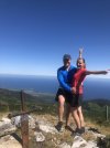
We actually went all the way to that antennae in your first photo, didn’t turn at the mojone - there’s a monument up there (as well as several goats and some elderly dogs) - and you can actually still get down from the other side without backtracking. One of my favorite Camino memories!
 

Attachments

  • 9F05D7BB-8050-48B8-8D47-AF6BB0C18026.jpeg
    9F05D7BB-8050-48B8-8D47-AF6BB0C18026.jpeg
    1.5 MB · Views: 59
  • F4CC5FDD-BCD8-4773-9B89-719E498F26C4.jpeg
    F4CC5FDD-BCD8-4773-9B89-719E498F26C4.jpeg
    824.4 KB · Views: 62
...and ship it to Santiago for storage. You pick it up once in Santiago. Service offered by Casa Ivar (we use DHL for transportation).
In good weather the mountain route is fantastic. The negative hype isn’t warranted. I think they want pilgrims to walk through the coastal towns and spend money. Fair enough. I just finished the Norte and this time walked the coastal route and it was very pretty. So two good options!!
Not the first time I have heard that locals have 'co-opted' the route for economic gain ( and I completely understand why they would do that). There is a spot on the Portuguese where the arrows send you along a road and through a couple of towns rather than by a most exquisite river walk. Thankfully it was actually noted in my guide. 😅
 
Perfect memento/gift in a presentation box. Engraving available, 25 character max.
Seems not much has changed … This was my post from April 2019
Thanks everyone for your quick replies. I ended up walking the coastal route ( as advised strongly by Pepe in Soto de Luiña ) since all the pilgrims I asked were going that way. Weather was fine but there had been rain so it was a lot of muddy trails and crossing streams and constant up and down hills so not sure if it was the best choice ! Also although called the coastal route there was not much coastal scenery until the end. Nevertheless it was all part of my Camino journey .
 
Thanks for your posts and pics - really lifted my spirits this morning. I stayed at Soto de Luina May 2019 and planned to do the mountain route. The guy at the albergue pleaded with me not to risk my life! I was right up for for taking the route - but when I got to the turn off the cloud base was pretty low and that tipped me against. I didnt fancy getting up high and then lost in the mist. I then spent the rest of the morning looking left with the top of the mountain range bathed in sun - teasing me! Look forward to the next time!
 
Not the first time I have heard that locals have 'co-opted' the route for economic gain ( and I completely understand why they would do that). There is a spot on the Portuguese where the arrows send you along a road and through a couple of towns rather than by a most exquisite river walk. Thankfully it was actually noted in my guide. 😅
interesting... which stretch is that?
 
The focus is on reducing the risk of failure through being well prepared. 2nd ed.
This is a pitch to follow the mountain route from Soto de Luiña😊. The hospitalero in the municipal will discourage you quite profusely (difficult and no services for 19 km) but in good weather and if you are fit I really recommend it.

The majority of pilgrims take the coastal route but as I had walked it 5 years ago I decided to go through the mountains. It was no walk in the park with elevation gains of 750 meters and some tricky narrow downhills with loose rocks but if you're fit it is really worthwhile.View attachment 129216View attachment 129217
I think I might do that on my next Norte as I didn't finish my first one. Where is it exactly. I climb mountains and volcanoes 2-3 times a week and sometimes do 750 meters so it shouldn't be a problem. Thanks for the tip.
 
Is there anyway to take the mountain route and walk down to Ballota without having to back track to Soto Luna or from Cadavedo?
 
Holoholo automatically captures your footpaths, places, photos, and journals.
Is there anyway to take the mountain route and walk down to Ballota without having to back track to Soto Luna or from Cadavedo?
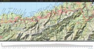
The gronze map I’ve put in here shows that Ballota is almost directly north of the high point of the mountain route. I don’t remember seeing any trails that descended towards the ocean, but that doesn’t mean they aren’t there. I have used my wikiloc map function to search for trails that both pass through Ballota and the high point of the mountain alternative and the only thing I found was a circular route that went from Ballota back to Soto, then up to the mountain ridge, and then down to Cadavedo and back to Ballota. Maybe someone with a better map function or more tracks can find something.

EDADB596-031C-4221-9DAB-8E7C4DCDA4B7.png
 
Ideal sleeping bag liner whether we want to add a thermal plus to our bag, or if we want to use it alone to sleep in shelters or hostels. Thanks to its mummy shape, it adapts perfectly to our body.

€46,-
The gronze map I’ve put in here shows that Ballota is almost directly north of the high point of the mountain route. I don’t remember seeing any trails that descended towards the ocean, but that doesn’t mean they aren’t there. I have used my wikiloc map function to search for trails that both pass through Ballota and the high point of the mountain alternative and the only thing I found was a circular route that went from Ballota back to Soto, then up to the mountain ridge, and then down to Cadavedo and back to Ballota. Maybe someone with a better map function or more tracks can find something.

View attachment 129764
I was one who walked the main coastal route (rarely on a road) on this stage and other than just a few beautiful ocean views, the rest was lots of ups and downs as you can see on the elevation profile. I practically needed a machete😉 to hack through the many eucalyptus forests. It was definitely not a "walk in the park", but it looks like the high route also can have some potential drawbacks, too.
Here is what I wrote about it last April...

"We tried our best to take the coastal routes, but it seemed more often than not we were funneled in to eucalyptus forests, going up and down valleys with paths filled with many rocks; I had to be careful to not roll my foot on the downhills. There were numerous pretty clumps of purple columbine added to the drab forest floor path.
One yellow arrow said "costa" so we followed it, but we never saw any water, only more ups and downs in the woods; disappointing and tiring.

Finally, outside Novellana, we saw beautiful views at Playa del Silencio, which was our favorite area. It was worth the climb down and up and many people were there out on Sunday drives. Later on was Playa Calabon, where people were taking picnics down to the beach.

Occasionally we were on country lanes with lovely colorful wild flowers along the road and many of the homes had horreos. All were shaped in a perfect square and some were refurbished for storage and had carports below.
We ended the day in Cadavedo, a town where they have some lovely cliff beach views seen from a local park."
 
Join the Camino cleanup. Logroño to Burgos May 2025 & Astorga to OCebreiro in June

❓How to ask a question

How to post a new question on the Camino Forum.

Most read last week in this forum

Planning on walking Norte-Primitivo starting about June 10, 2025. Are the albergues very busy at that time and also what will the weather be? I did this the end of August and September of 2017 and...

Featured threads

❓How to ask a question

How to post a new question on the Camino Forum.

Featured threads

Forum Rules

Forum Rules

Camino Updates on YouTube

Camino Conversations

Most downloaded Resources

This site is run by Ivar at

in Santiago de Compostela.
This site participates in the Amazon Affiliate program, designed to provide a means for Ivar to earn fees by linking to Amazon
Official Camino Passport (Credential) | 2024 Camino Guides
Back
Back
Top