Search 74,075 Camino Questions

Leaving the River Walk in Lalín — new text for 2019 guide

peregrina2000

Moderator
Staff member
Years ago, leaving the river walk, the arrows took you straight up to the N-525. Hairy. Then a new route was marked, but it caused confusion for those of us who remembered the old route and were trying figure out the differences. Now I think the old route is a thing of the past, and the new route is well marked. So this is the prose I propose. I have put a question at the one point where I am unsure. I am sure Kinky will enlighten me!

Mojón (? Or is it an arrow?) takes you up from the river. You will not go all the way up to the national highway, N-525, but will rather turn right and parallel it for a short distance. Then cross the N-525 and turn left. (Is this the point where the arrow is on the shed next to a little church or is that later on?). You will be on a back road, and this will take you behind the Hotel Torre do Deza. At the hotel, you continue on a back road, until you emerge at a roundabout. There is an arrow on a stop sign. The gravel road you are directed to takes you to the underpass (going under the superhighway) and you emerge in A Laxe.
 
The focus is on reducing the risk of failure through being well prepared. 2nd ed.
Hi Laurie,

I distinctively remember that part: we chose the road, because to the right was a mucky hell. Aftera a few meters, we found arrows again, so we were wondering which way was the right one.
Also, leaving Rodeiro, the mayor of Rodeiro, a very friendly, nice young fellow, told us to avoid the dirt track and just follow the hardshoulder of the road nearly all the way to Lalín, he said that dirt track was not very well kept. It was pissing down with rain, so we did not hesitate to choose the hardshoulder.
 
Years ago, leaving the river walk, the arrows took you straight up to the N-525. Hairy. Then a new route was marked, but it caused confusion for those of us who remembered the old route and were trying figure out the differences. Now I think the old route is a thing of the past, and the new route is well marked. So this is the prose I propose. I have put a question at the one point where I am unsure. I am sure Kinky will enlighten me!

Mojón (? Or is it an arrow?) takes you up from the river. (Most probably you mean two mojones on each side of the small bridge that takes you over the river from left to right bank which are in my photo in another thread. After crossing the bridge you go slightly uphill in the direction of N-525 = perpendicularly to the river) You will not go all the way up to the national highway, N-525, but will rather turn right (LEFT!!! when reaching small church) and parallel it for a short distance. Then cross the N-525 and turn left. (Is this the point where the arrow is on the shed (garage) next to a little church or is that later on? - before that, see previous remark)). Then turn right off the N-525 after approx.10 meters. You will be on a back road, and this will take you behind to the Hotel Torre do Deza. At the hotel, you continue on a back road (to the right and behing the hotel), until you emerge at a roundabout (after turning left and down the street). Turn right at the roundabout and stay on main street through Poligono Industrial and then There is an arrow on a stop sign. The gravel road you are directed to slightly to the right takes you to the underpass (going under the superhighway) and you emerge in A Laxe.

That's the best I can do. It's in your quote above in bold, Laurie.

I know I have good sense of orientation and I walked this stretch twice and never got lost but it is really so simple. I think if you over-do the text then it would be just left-right-left-down-right-up-left etc. and the people will be a bit surprised why so detailed description when there are arrows (mostly not just one) on every turn. But if you like I can explain it in detail although I'm sure we can tick this off as a Invierno mystery :D
 
The 2024 Camino guides will be coming out little by little. Here is a collection of the ones that are out so far.
That's the best I can do is in your quote above in bold, Laurie.

I know I have good sense of orientation and I walked this stretch twice and never got lost but it is really so simple. I think if you over-do the text then it would be just left-right-left-down-right-up-left etc. and the people will be a bit surprised why so detailed description when there are arrows (mostly not just one) on every turn. But if you like I can explain it in detail although I'm sure we can tick this off as a Invierno mystery :D

Ok, that’s good enough for me. I will leave it simple — describe the mojones on the river walk, the arrow on the shed across from the ermita, and the fact that you will pass behind the four-star Hotel Torre do Deza (and I will some of what @ranthr said about her stay there). And then on gravel road to tunnel under the highway. Even that may be overkill, but it will be a lot less than what is there currently. ;)
 
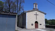
"the arrow on the shed across from the ermita " it's not across (as across the street), it's on neighboring building (garage) to the left:

20180520_143431 (RS).webp

20180520_143459 (RS).webp

You actually bump into it coming up from the river but it is rather small.

If you are still unsure of some parts I can write short description from either the private albergue or even more convenient from the Lalin church with street names and photos and GPS and all. In previous postings I skipped the stretch after the church and behind the hotel for example because it's so obvious but I have photos for that too.
 
"the arrow on the shed across from the ermita " it's not across (as across the street), it's on neighboring building (garage) to the left:

View attachment 49094

View attachment 49095

You actually bump into it coming up from the river but it is rather small.

If you are still unsure of some parts I can write short description from either the private albergue or even more convenient from the Lalin church with street names and photos and GPS and all. In previous postings I skipped the stretch after the church and behind the hotel for example because it's so obvious but I have photos for that too.


Thanks, Kinky, I appreciate the offer, but if things are all clear now, there is no need unless you are bored and feel like writing it up.;) I was surprised that @Bad Pilgrim had trouble finding the river walk, because I thought the guide was really clear and straightforward.

Here’s what we wrote for leaving Lalín. Do you think it’s unclear? (Or is BP right that he is “directionally challenged”?). I also say that anyone who is lost should just ask for “Paseo Fluvial.” EVERYONE in town knows where it is.

To get to the river walk from the town church, walk down with the church behind you, on the street Rúa Colón. You will come to a plaza with a monument to Joaquín Loriga, an early 20th century aviator. Go past that square, continue downhill, till you come to a big playground at the edge of the town. You will be able to join the river walk there; take it to your left.
 
Get a spanish phone number with Airalo. eSim, so no physical SIM card. Easy to use app to add more funds if needed.
...
Here’s what we wrote for leaving Lalín. Do you think it’s unclear? (Or is BP right that he is “directionally challenged”?). I also say that anyone who is lost should just ask for “Paseo Fluvial.” EVERYONE in town knows where it is.

To get to the river walk from the town church, walk down with the church behind you, on the street Rúa Colón. You will come to a plaza with a monument to Joaquín Loriga, an early 20th century aviator. Go past that square, continue downhill, till you come to a big playground at the edge of the town. You will be able to join the river walk there; take it to your left.
That's it. Maybe just mention that the monument should be on the righthand side when crossing that square (Praza do Concello) and then down and through the sports/playground straight (OK, the road veers slightly to the left but has no righthand turnoffs anyway so "straight" is appropriate term here I think).
 
Just to be sure I get this about the arrow on the shed located right next to the ermita. Are this ermita and shed before you cross the N-526 or after? Thanks K1.
Hi, Laurie :)

"This arrow" is located before N-525 (not N-526) on the garage (shed if you want...). The "garage" is located approx.2 meters to the left (see 1st photo in post no5) of the little church as you come up to them.

2nd photo in post no5 is "close-up" of the 1st photo in the same post. I thought it was obvious from the photos, sorry... :)
 
The 2024 Camino guides will be coming out little by little. Here is a collection of the ones that are out so far.
Years ago, leaving the river walk, the arrows took you straight up to the N-525. Hairy. Then a new route was marked, but it caused confusion for those of us who remembered the old route and were trying figure out the differences. Now I think the old route is a thing of the past, and the new route is well marked. So this is the prose I propose. I have put a question at the one point where I am unsure. I am sure Kinky will enlighten me!

Mojón (? Or is it an arrow?) takes you up from the river. You will not go all the way up to the national highway, N-525, but will rather turn right and parallel it for a short distance. Then cross the N-525 and turn left. (Is this the point where the arrow is on the shed next to a little church or is that later on?). You will be on a back road, and this will take you behind the Hotel Torre do Deza. At the hotel, you continue on a back road, until you emerge at a roundabout. There is an arrow on a stop sign. The gravel road you are directed to takes you to the underpass (going under the superhighway) and you emerge in A Laxe.

Two remarks:

- Yes, there is a mojón (not a simple arrow) taking you off the river walk (Two mojones actually, counting the one by the small bridge at almost the same spot.)

- The Camino does not reach the roundabout at the Hotel Deza anymore. It crosses the road further up and enters the path on the grassy slope that is seen on Kinky's photos.

Although I agree that there are waymarks all the way now so it is not a matter of confusion anymore. There is no need to be precise about it in the Guide.

BP
 
Oooohhhhhh, now I get it. Yes, I know you were trying to tell me that earlier, BP, but now I really get it! I will delete most of the detail since that is just likely to confuse people. I don’t think many people stay at the hotel anyway, though I think @ranthr did. I can leave a mention of it not being far from the hotel and give its address. Thanks.
 
Thanks to both Kinky and BP. You are both right that it is a mistake to over-do it and over-think it now that it is all very clear. I am so sorry to have taken so long to realize what was going on.

So here is all I will say. (As long as you tell me it’s accurate and clear enough).

When the markings take you off the river walk, you do not go straight up to the N-525, but rather turn right and parallel the N-525 for a short distance. When you cross the highway, you will turn left, paralleling the national highway and the industrial park until the arrows take you to a roundabout with at least four roads converging. Continue on a crushed rock trail that is on the right side of the autovía. Soon you will be directed to the left and under the highway through a tunnel. When you emerge, you are in A Laxe.
 
A selection of Camino Jewellery
Thanks to both Kinky and BP. You are both right that it is a mistake to over-do it and over-think it now that it is all very clear. I am so sorry to have taken so long to realize what was going on.

So here is all I will say. (As long as you tell me it’s accurate and clear enough).

When the markings take you off the river walk, you do not go straight up to the N-525, but rather turn right and parallel the N-525 for a short distance. When you cross the highway, you will turn left, paralleling the national highway and the industrial park until the arrows take you to a roundabout with at least four roads converging. Continue on a crushed rock trail that is on the right side of the autovía. Soon you will be directed to the left and under the highway through a tunnel. When you emerge, you are in A Laxe.
First bold-ed part:
LEFT, Laurie, LEFT! (add "...when you come to a little church...") Laurie don't mention N-525 at this point because you can't see it and you'll confuse people!

The second bold-ed sentence is completely wrong and misleading description!!! And "at least four roads" meaning what??? 8? BTW there are only 3.

I will write detailed description and add photos here but only sometime in next 24 hours as right now my bed is awaiting me.
 
Last edited:
Thanks to both Kinky and BP. You are both right that it is a mistake to over-do it and over-think it now that it is all very clear. I am so sorry to have taken so long to realize what was going on.

So here is all I will say. (As long as you tell me it’s accurate and clear enough).

When the markings take you off the river walk, you do not go straight up to the N-525, but rather turn right and parallel the N-525 for a short distance. When you cross the highway, you will turn left, paralleling the national highway and the industrial park until the arrows take you to a roundabout with at least four roads converging. Continue on a crushed rock trail that is on the right side of the autovía. Soon you will be directed to the left and under the highway through a tunnel. When you emerge, you are in A Laxe.

Wow,

you are really fond of that roundabout, Laurie! :O) I would say no roundabout at all, but perhaps I am making matters worse. I leave it to Kinky to sort this out.

I think I get what you mean with the left-right thing that Kinky reacted to above. But first time I read it I didn't quite understand it either so apparently it can cause confusion.

/BP
 
Sorry, I really am not trying to torture you guys. Don’t worry, I will just delete the whole thing since it seems that it is totally clear. No need to rewrite it, kinky. This shows you how difficult it is to imagine a new route when you are only vaguely. familiar with the old route! But since no pilgrim for the last couple of years has had a problem,I will just delete it all. So sorry guys.
 
Holoholo automatically captures your footpaths, places, photos, and journals.
Sorry, I really am not trying to torture you guys. Don’t worry, I will just delete the whole thing since it seems that it is totally clear. No need to rewrite it, kinky. This shows you how difficult it is to imagine a new route when you are only vaguely. familiar with the old route! But since no pilgrim for the last couple of years has had a problem,I will just delete it all. So sorry guys.

Don't worry Laurie,

This section is so well marked now that… not even I could go wrong! XOD

/BP
 
Ok, got it.

When the mojón takes you off the river walk, you will start to ascend. Turn left at a little ermita (arrow on the adjacent shed/garage) and continue on that back road. This means you will avoid walking on the side of the national highway (as the camino did originally) or through the industrial park. You will come to a gravel road that takes you to a tunnel under the super highway and enter A Laxe.


Or is that still wrong? (She says trembling with fear)
 
Dont provoke the Wrath of Bad Pilgrim...….. :OP

Well, you still walk through the industrial park I would say. There is a walk on a path in between the buildings for a few hundred mtrs, but then you are back next to the N-525. Until that gravel road begins (I don't remember exactly where it begins.)

BP
 
€2,-/day will present your project to thousands of visitors each day. All interested in the Camino de Santiago.
Dont provoke the Wrath of Bad Pilgrim...….. :OP

Well, you still walk through the industrial park I would say. There is a walk on a path in between the buildings for a few hundred mtrs, but then you are back next to the N-525. Until that gravel road begins (I don't remember exactly where it begins.)

BP

Ok, then, how about if I just add the bold words, to make clear that there . How about this:

When the mojón takes you off the river walk, you will start to ascend. Turn left at a little ermita (arrow on the adjacent shed/garage) and continue on that back road. This means you will not have as much walking along the national highway or through the industrial park as earlier Camino routes had. There are no problems with marking on this new route. You will come to a gravel road that takes you to a tunnel under the super highway and enter A Laxe.
 
€2,-/day will present your project to thousands of visitors each day. All interested in the Camino de Santiago.
I've just walked there a few days ago, so I thought I'd add something in this thread :)

Finding the river walk and following it was not a problem; problems started with leaving it. The mojón and arrows poined to a dirt track, and it was quite literally a dirt track: even though the day was sunny and warm, it seemed to be just a pool of mud. Thankfully, it looked worse than it was, and after the first few metres, the track got much better. But up there, in the industrial park, there was a lonely mojón pointing diagonally to a small grass field. I chose to walk straight up, along an asphalt road, and, quite simply, got lost in the park. Fortunately, I remembered the part in the guide about that great Ford building, saw it, and was able to find my way down, where I picked up the arrows again. The whole place between the nice river walk and the tunnel leading to A Laxe is just one big mess. One of the two places on the otherwise very well-marked Invierno were I got lost (the other being Soldón after passing under the national highway)!
 
Last edited:
I've just walked there a few days ago, so I thought I'd add something in this thread :)

Finding the river walk and following it was not a problem; problems started with leaving it. The mojon and arrows poined to a dirt track, and it was quite literally a dirt track: even though the day was sunny and warm, it seemed to be just a pool of mud. Thankfully, it looked worse than it was, and after the first few metres, the track got much better. But up there, in the industrial park, there was a lonely mojon pointing diagonally to a small grass field. I chose to walk straight up, along an asphalt road, and, quite simply, got lost in the park. Fortunately, I remembered the part in the guide about that great Ford building, saw it, and was able to find my way down, where I picked up the arrows again. The whole place between the nice river walk and the tunnel leading to A Laxe is just one big mess. One of the two places on the otherwise very well-marked Invierno were I got lost (the other being Soldon after passing under the national highway)!
I guess that I'll really have to put together a small guide Lalin - A Laxe with exact distances, descriptions, photos and GPS track after all ;)

I walked it for the second time in 2018 and although the Camino through parque industrial was rerouted (first time for me) it was really easy peasy to find a way.
 
Last edited:
I guess that I'll really have to put together a small guide Lalin - A Laxe with exact distances, descriptions, photos and GPS track after all ;)

I walked it for the second time this year and although the Camino through parque industrial was rerouted (first time for me) it was really easy peasy to find a way.
Oh, please do!:) I certainly didn't find it easy - and I'm really thankful to the guide for mentioning the Ford building and other details :)
 
Get a spanish phone number with Airalo. eSim, so no physical SIM card. Easy to use app to add more funds if needed.
I guess I walked up the muddy dirt path where the mojons and arrow pointed upwards. Ended up on the highway where the camino crossed the road. I took the highway to the left to get to my hotel a km ahead where I met caminosigns again. Had no problems in following arrows from outside the hotel on the small road through the industrial area parallell to the highway.
 
Oh, no, I am going to have to go back to square one on this. :-( Or better said, I will have to wait till Kinky clears things up for us so I can rework the language in the guide. :-) Thanks for the headsup, Athena, and I am very glad the guide has been helpful. Buen camino, Laurie
 
I guess I walked up the muddy dirt path where the mojons and arrow pointed upwards. Ended up on the highway where the camino crossed the road. I took the highway to the left to get to my hotel a km ahead where I met caminosigns again. Had no problems in following arrows from outside the hotel on the small road through the industrial area parallell to the highway.
The path parallel to the highway you took through the industrial park was old route but only from your hotel onward. Now the Camino turns right and goes behind the hotel and there's where I guess @Athena Atterdag had some problems. Anyway this stretch with its rerouting is nicer now than it was in 2014 when I first walked it. But even if you stay on the highway and service streets through industrial area it isn't all that bad.
 
Join the Camino cleanup. Logroño to Burgos May 2025 & Astorga to OCebreiro in June
The path parallel to the highway you took through the industrial park was old route but only from your hotel onward. Now the Camino turns right and goes behind the hotel and there's where I guess @Athena Atterdag had some problems. Anyway this stretch with its rerouting is nicer now than it was in 2014 when I first walked it. But even if you stay on the highway and service streets through industrial area it isn't all that bad.
Athena, kinky posted a lot of pics and a description of the river walk exit. Does it jar your memory about what could have happened?

https://www.caminodesantiago.me/com...o-summer-2018-observations.58827/#post-701007
 
Athena, kinky posted a lot of pics and a description of the river walk exit. Does it jar your memory about what could have happened?

https://www.caminodesantiago.me/com...o-summer-2018-observations.58827/#post-701007
Even on CF with all the spilleage of yellow arrows and mojones people take the wrong turns. It won't be any different whatever the precise your guide will be, Laurie. I can swear it's really easy peasy now to get from riverwalk to A Laxe albergue. I still think people have more troubles getting to the river walk though :)

But if you think that short stretch deserves even more precise description I can still make it.
 
Even on CF with all the spilleage of yellow arrows and mojones people take the wrong turn. It won't be any different whatever the precise your guide will be, Laurie. I can test it's really easy peasy now to get from riverwalk to A Laxe albergue. I still think people have more troubles getting to the river walk :)

But if you think that short stretch deserves even more precise description I can still make it.

Hi, K1,
Let’s leave it for now, and see what the February and spring peregrinos say. There will be a bunch heading out soon, and they can always check your photos.
 
Get a spanish phone number with Airalo. eSim, so no physical SIM card. Easy to use app to add more funds if needed.
Don't worry Laurie

This section is so well marked now that… not even I could go wrong! XOD

/BP

Hi all
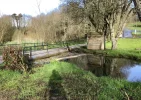
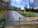
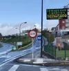
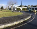
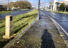
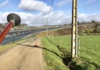
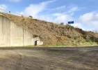
Taking a chance here - this is the way “I”exited the river walk but it may not be the way given in the guide. On paths- No mud, no traffic I remember. There were majones or signs., or arrows visible on posts, gutters , roundabouts etc.
When walking along then river walk last July., I ambled slowly to soak it in. It was beautiful. Little bridges take you right or left side (if you want to play). You end up walking on the left though.

NOTE:::: the first two pics are “NOT” the way I walked.
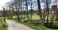
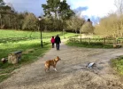
I was walking the last section with a local couple (pic with dog).. when we arrived at the majone and bridge in
Pic 1 I indicated farewell. They said : no don’t go that way — too muddy. A bit further up is better.
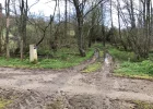
My exit. Pic 3 isn’t much further up though.

Pic 2 shows the muddy exit (april2018) if you take first pic direction I don’t know how it goes further on as I didn’t take it.

MY EXIT here :
Pic 3. Shows the local couple leaving me and dog facing direction to take. There is also (on the left ) a yellow arrow.

Pic 4. Is my exit bridge on approach.

Pic 5 immediately after you cross the water you come to this paved road with familiar camino signage. Heading up.

Pic 6. You’ll find it signed all the way up (can only fit 10 pics ). When you reach this point. You can see the yellow arrow on the post of the dual car sign

Pics7 and 8. (7 Arrow on gutter) (8 you can’t miss the majone).

Pic 9. At the large roundabout - take the dirt road to your right., you can just see the underpass in this pic
Pic 10. Not far down the dirt track is the yellow arrow taking you under the highway.

It was a very safe way.

The muddy way is probably ok too I don’t know., it couldn’t have been any muddier than many other parts of the Invierno I experienced.

Buen Camino
Annie
 

Attachments

  • 2D404451-1ADA-4720-8AEA-A65CA678368E.webp
    2D404451-1ADA-4720-8AEA-A65CA678368E.webp
    351.5 KB · Views: 10
  • B38662E2-104C-4491-A842-32DD476DEB3B.webp
    B38662E2-104C-4491-A842-32DD476DEB3B.webp
    456.1 KB · Views: 11
  • 73FDC481-0CFB-44B7-BAC1-C0A16AF365A6.webp
    73FDC481-0CFB-44B7-BAC1-C0A16AF365A6.webp
    389.7 KB · Views: 11
  • F4725391-4B98-4DAD-8E1C-A38FE6F5B017.webp
    F4725391-4B98-4DAD-8E1C-A38FE6F5B017.webp
    434.6 KB · Views: 11
  • D3066D60-A50D-4B11-8446-2B96F36B94E1.webp
    D3066D60-A50D-4B11-8446-2B96F36B94E1.webp
    309.6 KB · Views: 11
  • 1C157E9E-303D-4ECB-A20F-BABC69878353.webp
    1C157E9E-303D-4ECB-A20F-BABC69878353.webp
    225.6 KB · Views: 11
  • 260F33A4-D290-4BAB-8919-33F53D3063B3.webp
    260F33A4-D290-4BAB-8919-33F53D3063B3.webp
    276.3 KB · Views: 11
  • A24A9E2B-F2E5-4F5E-A095-123ACC2FE912.webp
    A24A9E2B-F2E5-4F5E-A095-123ACC2FE912.webp
    372.2 KB · Views: 13
  • D0B00D96-1DED-4F12-9A21-D01B86B4CC01.webp
    D0B00D96-1DED-4F12-9A21-D01B86B4CC01.webp
    261.6 KB · Views: 12
  • ECCFF365-FD70-4621-A37D-11F9A3F4D2A7.webp
    ECCFF365-FD70-4621-A37D-11F9A3F4D2A7.webp
    233 KB · Views: 10
Last edited:
Great pictures Annie! I hope to be back in the summer, and I will take a bunch of pictures too, and then I will compare them all when Iget back home. Looks like there are several options, though I’ll bet the distance of the separate paths is really pretty small. I see lots of arrows on your alternative, so it looks like Lalín is taking good care of the pilgrim traffic.

I really liked Lalín btw, I thought the people were exceptionally friendly and kind. Nice lively street ambiente, too.
 

❓How to ask a question

How to post a new question on the Camino Forum.

Most read last week in this forum

Hola, Is there a walking route connecting the Frances route to the Invierno route AFTER O Cebreiro? Walking the Frances I love the ascent to, and stay in O Cebreiro and would like to visit Samos...

Featured threads

❓How to ask a question

How to post a new question on the Camino Forum.

Featured threads

Forum Rules

Forum Rules

Camino Updates on YouTube

Camino Conversations

Most downloaded Resources

This site is run by Ivar at

in Santiago de Compostela.
This site participates in the Amazon Affiliate program, designed to provide a means for Ivar to earn fees by linking to Amazon
Official Camino Passport (Credential) | 2024 Camino Guides
Back
Back
Top