Search 74,075 Camino Questions

Gradient Graphs for Camino Frances

The one from Galicia (the round) and the one from Castilla & Leon. Individually numbered and made by the same people that make the ones you see on your walk.
This is an extract from my Web-App (under construction) for Camino Frances and shows the gradient graphs (with maps) for the combined as well as 32 individual walks.

Select walks (in groups of 5 to 7) at the base and use scroll bar to view.

Gradient Graph
Has anyone produced a gradient diagram to actual scale? With the same scale of distances on both the x and y axes?
 
Transport luggage-passengers.
From airports to SJPP
Luggage from SJPP to Roncevalles
The 2024 Camino guides will be coming out little by little. Here is a collection of the ones that are out so far.
Bless your heart for putting all this work into this project. So forgive me for saying that the seemingly random elevation scales in no way reflect any degree of difficulty I have encountered on my Caminos. Brierley guide, gronze website, and a thread on here showing charts for all stages (to my mind) give a more accurate description of what to expect.
 
Last edited:
The focus is on reducing the risk of failure through being well prepared. 2nd ed.
Last edited:
Thanks, Rick. But, I'm looking for one at actual scale. That is, of a block on the y-axis is 50m, a block on the x-axis would also be 50m. That would provide an accurate representation of the terrain.
I don't think you would find this very useful. I don't think I've ever seen a profile like that other than one I created as an experiment. That was one of the entire CF. It was something like two pixels per kilometer with all elevations shown with three pixels.

For a Camino stage take a look again at the profile I created. Two boxes per kilometer on the horizontal and twenty on the vertical. Picture the chart with just three boxes on the vertical. I don't think most would like a profile like it.
 
The one from Galicia (the round) and the one from Castilla & Leon. Individually numbered and made by the same people that make the ones you see on your walk.
Bless your heart for putting all this work into this project. So forgive me for saying that the seemingly random elevation scales in no way reflect any degree of difficulty I have encountered on my Caminos. Brierley guide, gronze website, and a thread on here showing charts for all stages (to my mind) give a more accurate description of what to expect.
Thanks for your reply and I will try to explain. The very first selection is "All" which shows the whole route elevation with map on top in green so the idea is to view that first to get an overall idea of "where the big bumps are".

As for random elevation scales this is an AI auto function in Google Earth that simply uses the low/high points for THAT particular walk and has the numbers on the left.

The graphs also include a line with all the "stats" and for me the main one (as far as sore feet are concerned) is the CUMULATIVE figure (which I highlight in Red/Green) eg for Walk 1 where Napoleon is 1492 meters but Valcarlos is 1811 meters, even though it does not go as high.

And yes, I did twig Walk 1 graphs scales to show the RELATIVE heights.
 
Thanks, Camo - that's going to be very useful.

But was anybody else puzzled by the 'north is down' orientation? Walking right-to-left feels backwards to me.
 
As for random elevation scales this is an AI auto function in Google Earth that simply uses the low/high points for THAT particular walk
Whilst that is very useful and accelerates the process, it is then, depending on the context, useful to manually scale the vertical access of the jpg or png images to suit your purpose.

I this case it appears from comments above (and I would agree) the same vertical metres / cm of the image - ie a consistent vertical scale so the the Meseta is flatish and the Pyrenees are much more bumpy.

(Footnote: I don't think it is AI - it has been there for years and is just simple arithmetic nothing artificial nor very intelligent, just an auto function)
 
Get a spanish phone number with Airalo. eSim, so no physical SIM card. Easy to use app to add more funds if needed.
Thanks, Camo - that's going to be very useful.

But was anybody else puzzled by the 'north is down' orientation? Walking right-to-left feels backwards to me.
North is NOT always down eg (pun intended) on The North Downs Way we are going East so North will be up.

To explain the starting point is the Google AI/macro/script/boundscript/flowchart (or whatever you may want to call it) has decided (in the year dot) to have the gradient start on left of screen and go to right of screen but in the top HALF of the screen it fits the map to suit with North at top. Please try it yourself in Google Earth!

For myself from 2016 I have created over 1,000 of these so have "automated" the process so I can "do these in my sleep" and move on to the flyover which is far more involved.

But for my elevation process I first reduce the graph to bottom one third and secondly "twirl" the map so the walk is the SAME left to right, so eg the highlight of the high point on the graph lines up with the position on the image above.

Then I take a screenie and use my own macro in PSPro to make it fit into my html iframe for the Web-App.

That's it - it works for me and others can do as they please or do nothing at all.
 
Thanks, Rick. But, I'm looking for one at actual scale. That is, of a block on the y-axis is 50m, a block on the x-axis would also be 50m. That would provide an accurate representation of the terrain.
I used https://gpsvisualizer.com/profile to draw my profile graph. You can use that to create profiles from GPS tracks pretty much any way you want. This morning I took a track of the Napoleon Route and plotted it using 25 x 25 pixel blocks to represent 1km x 1km horizontal and vertical distances. This is what I got:

Screenshot 2024-07-26 8.52.16 AM.png

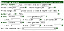
It took way too much trial and error as it has been a few years since I used the tool. To save you some time I give you an example of how to fill in the parameters section. This is what I used to get the above profile:

Screenshot 2024-07-26 8.53.22 AM.png

Although I specified Jpeg output I took screenshots and they came out in PNG format.
 
I used https://gpsvisualizer.com/profile to draw my profile graph. You can use that to create profiles from GPS tracks pretty much any way you want. This morning I took a track of the Napoleon Route and plotted it using 25 x 25 pixel blocks to represent 1km x 1km horizontal and vertical distances. This is what I got:

View attachment 175309

It took way too much trial and error as it has been a few years since I used the tool. To save you some time I give you an example of how to fill in the parameters section. This is what I used to get the above profile:

View attachment 175310

Although I specified Jpeg output I took screenshots and they came out in PNG format.
Nice work Rick but very time consuming considering Google Maps simply does it FOR you by hitting "show gradient profile" AND it has the satellite map so you can see where the "bumps" are.

But LenB (and others) seemed more concerned with the flatter routes so could you perhaps do one of those for us and I will try to do the same in Google Earth as a comparison.
 
Get a spanish phone number with Airalo. eSim, so no physical SIM card. Easy to use app to add more funds if needed.
Nice work Rick but very time consuming considering Google Maps simply does it FOR you by hitting "show gradient profile" AND it has the satellite map so you can see where the "bumps" are.
I assume you mean Google Earth here and not Google Maps. I only have easy access to my smartphone and I'm not even going to try Google Earth on it.

But LenB (and others) seemed more concerned with the flatter routes so could you perhaps do one of those for us and I will try to do the same in Google Earth as a comparison.
Sorry, I politely decline. I feel I've already done enough.
 
I assume you mean Google Earth here and not Google Maps. I only have easy access to my smartphone and I'm not even going to try Google Earth on it.


Sorry, I politely decline. I feel I've already done enough.
That's cool Rick - I posted this Web-App extract as Information Only but got some suggestions for modifications that I will now try to incorporate into the display to make Degree of Difficulty more clear between the various walks.
 
That's cool Rick - I posted this Web-App extract as Information Only but got some suggestions for modifications that I will now try to incorporate into the display to make Degree of Difficulty more clear between the various walks.
One of the first improvements you need to make is to use the walking routes, and not some other track, if this is going to be of any value to walking pilgrims. From a quick look at the first three or four stages, there are clear descpancies that need to be addressed.
 
Last edited:
...and ship it to Santiago for storage. You pick it up once in Santiago. Service offered by Casa Ivar (we use DHL for transportation).
One of the first improvements you need to make is to use the walking routes, and not some other track, if this is going to be of any value to walking pilgrims. From a quick look at the first three or four stages, there are clear descpancies that need to be addressed.
Don't follow Doug, I don't NEED to do anything and this MODIFICATION (not improvement) is way down my to-do list.

But main issue is this is an extract from the introduction of the Web-App (under construction) which I am obviously not permitted to link to here.

Also the paths I use are the official ones from this forum and verified by way of Camino waymarkers in the "turn points" of the Virtual Tours.

This is MY Camino ie a HUGE task on a computer as I am no longer able to walk more than a few steps.
 
Also the paths I use are the official ones from this forum and verified by way of Camino waymarkers in the "turn points" of the Virtual Tours.
I have no doubt that this is a large task that you have chosen to take on, and any work you have done with Google Earth and Google Maps to improve the quality of the underlying geo-spatial data set they use will benefit walkers if they choose to use either of those products over the many other more accurate and reliable walking map apps available for the Camino routes.

My concern is that to create a tool suitable for planning purposes, and not just some entertaining flyover of a set of paths that currently is NOT the walking route, then it is important that this be based on the actual walking route. Despite your claim that this is based on 'official [routes] from this forum' there are clearly stages where the paths do not coincide with the walking routes. I have checked several of these now, and in the first five walks, as you have described them, four clearly don't follow the walking route. I recall that you have claimed over 90% accuracy. I suggest that if the same error rate is present in areas I haven't checked, the accuracy seems to be much, much less than that.

Let me give you two examples where it is abundantly clear that you are not using the walking routes:
  • In the route from Valcarlos to Roncesvalles, the route departs from the N135 shortly after Valcarlos at about this point, with coordinates of 43.04735, -1.32124. The path on the web app continues to follow the N135, which is not only incorrect, it would be very dangerous for a walking pilgrim to follow.
  • Leaving Pamplona, the walking route crosses the A-15 on the NA-6000, goes through Cizur Menor, skirts the SE edge of Zizur Mejor, goes through Zariquiegui before crossing the ridgeline running west from the Alto del Perdon. The web app route does none of that. More, leaving the ridgeline, the web app appears to follow the NA-6056, NA-1110, NA-6016 and perhaps the NA-6062 and NA-6064. Some of this might be an alternative to the steep descent from the area of the statues on the ridgeline of the Alto del Perdon, but it certainly isn't a recognised path on any of the mapping that I have seen. Those paths don't follow any of those roads.
Let me stress that these are not isolated instances. As I said earlier, four of the first five sections show routes that in whole or part bear little resemblance to the walking route. At this point, that makes your web app quite unsuitable as a planning tool, or as a tool to use while on the camino. If it is your intent that it be useful for those purposes, it is imperative that your foundational route information is correct and is able to be changed quickly to ensure that it remains correct.

When you first aired this project, I made similar observations, and pointed to specific areas where Google Maps was letting you down badly when it came to the accuracy and reliability of its geo-spatial data set for walking routes. I don't see how any of this has improved sufficiently in the meantime for anyone to recommend that pilgrims use these tools. I certainly wouldn't.
 
Last edited:
crosses the A-15 on the NA-6000, goes through Cizur Menor, skirts the SE edge of Zizur Mejor, goes through Zariquiegui before crossing the ridgeline running west from the Alto del Perdon.
Doug, first of all in the "modern world" if you want to describe a route you need to use the PDF of mapping which is Google MyMaps where you can draw/download a map, use a map someone else has created or even have the bot create it FOR you via its Sat Nav engine.

However in this case I am at a loss to understand how you could possible KNOW my routes as I have not given a link to my Web-Apps here for obvious reasons.

What I posted here was not even the Introduction to a Web-App but an extract from the introduction and I did that as "take it or leave it info" that might be useful to people planning a Camino Frances trip where they did not have time or ability to do the lot and needed to choose sections to match their abilities.

But obviously you don't like it so I have deleted it from my host site - living on an age pension I can use the saved space for other things and save on my hosting fees.
 
Get a spanish phone number with Airalo. eSim, so no physical SIM card. Easy to use app to add more funds if needed.
first of all in the "modern world" if you want to describe a route you need to use the PDF of mapping which is Google MyMaps where you can draw/download a map, use a map someone else has created or even have the bot create it FOR you via its Sat Nav engine.

That seems to be quite a rigmarole, and completely unnecessary when I can describe the route quite adequately in simple, plain English.

As an aside, I would be interested to know what term the abbreviation PDF represents here. I know it is a conventional file name extension for portable document format computer files, but that makes no sense to me here. Alternatives from https://www.acronymfinder.com/PDF.html include 'Pretty Damn Funny', and 'Please Don't F..t', neither of which seem to fit either!
However in this case I am at a loss to understand how you could possible KNOW my routes as I have not given a link to my Web-Apps here for obvious reasons.
I don't know your routes, but I was able to make a reasonable assessment of their alignment from the graphical information that you provided. Just the same as I have made a reasonable assessment that the Walk 4 route leaving Puente la Reina follows a minor road, the NA-1110 to the north of the A-12 before crossing around Maneru, something the walking track does not do. Perhaps your web apps would make these deviations from the walking paths more obvious. If they did, it might make it easier for others to actually help you present the walking path, rather than what is currently appearing.
What I posted here was not even the Introduction to a Web-App but an extract from the introduction and I did that as "take it or leave it info" that might be useful to people planning a Camino Frances trip where they did not have time or ability to do the lot and needed to choose sections to match their abilities.
My concern is that if the walking track you present is not the current alignment that has been way-marked, these are not providing the utility you suggest. I cannot see how you can claim that they are at all useful in their current state.
But obviously you don't like it so I have deleted it from my host site - living on an age pension I can use the saved space for other things and save on my hosting fees.
I think that is an unnecessary response. It's not whether I like what you are trying to do, it's about whether what you have done is presenting useful, reliable and accurate information. It isn't, and it should if it is to fulfill your own stated purpose here. And while it doesn't, I will continue to point this out so that forum members are not misled about this or any other routes you take on in this way.
 
Last edited:
The first task for anyone "making an app" is to find a reliable kml (or whatever) file or record one themselves. In this case I googled for one and it took me to this forum and the file the experts here were suggesting is called (ES) Camino Frances (Saint-Jean-Pied-de-Port - Santiago de Compostela).kmz which I have followed.

You are now suggesting it is flawed so could you please send me the file YOU rely on and I will do a cross check if I get the time.
 
the file the experts here were suggesting is called (ES) Camino Frances (Saint-Jean-Pied-de-Port - Santiago de Compostela).kmz
The forum doesn't recognize any experts, so any recommended files are just the recommendation of the member who posts.

If you can tell us where you got your track, perhaps someone can comment on it. If your file is from a source that is generally well-known on the forum, maybe some members would be interested in seeing the apparent differences.

Wikiloc is a great site for tracks. However, anybody who has walked a route and lived to tell the tale, can upload the file to Wikiloc, so you need to evaluate how reliable that person might be.
 
€2,-/day will present your project to thousands of visitors each day. All interested in the Camino de Santiago.
The first task for anyone "making an app" is to find a reliable kml (or whatever) file or record one themselves. In this case I googled for one and it took me to this forum and the file the experts here were suggesting is called (ES) Camino Frances (Saint-Jean-Pied-de-Port - Santiago de Compostela).kmz which I have followed.

You are now suggesting it is flawed so could you please send me the file YOU rely on and I will do a cross check if I get the time.
That might be a cycling route. The walking route with which I am familiar is here: https://centrodedescargas.cnig.es/CentroDescargasRWS/rest/descargarArchivo/usuarioMovil/11059901
 
That might be a cycling route. The walking route with which I am familiar is here: https://centrodedescargas.cnig.es/CentroDescargasRWS/rest/descargarArchivo/usuarioMovil/11059901
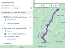
Thank you very much Doug and I plonked it (ie Valcarlos Route) into MyMaps along with my own version of what I call Walk 1a and here is the comparison

valcarlos1.png

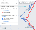
So it finally reveals (brown) the section through the "deep forest" that I knew was missing from my route (blue) and if I blow it up a bit we have

valcarlos2.png

And I have made that correction to my route.

So that's done for the 25 km diversion route but you are questioning the whole Camino Frances route I used which is 810 km long so I need to do a similar cross check if you could kindly sent me the appropriate file on which you base your questioning so I can see if I might need to do any more editing.
 
if you could kindly sent me the appropriate file on which you base your questioning so I can see if I might need to do any more editing.
I base my questions on my practical experience walking the route, although I find the Open Street Maps walking routes layer a useful tool when I am planning. It can be activated in the OSM apps in Android and iOS devices, and I suspect any other mapping app that uses OSM as a geo-spatial data source. Users of products like Mapy.cz, etc might be able to tell you that.
 
Ideal sleeping bag liner whether we want to add a thermal plus to our bag, or if we want to use it alone to sleep in shelters or hostels. Thanks to its mummy shape, it adapts perfectly to our body.

€46,-

❓How to ask a question

How to post a new question on the Camino Forum.

Most read last week in this forum

Can you tell me anything about the structure in my photograph? What was it part of, when was it built? that sort of thing. Thanks.
Feeling a little alone at CF. Where is it most likely that I won't be the only one in the albergue, Villar de Masarif, Villavante, Hospital de Orbigo or Astorga (which is probably too long for me...
I’m planning another Camino Frances, but this time can only do part of it. I’ll be walking from Pamplona for around 2 weeks; I like to walk around 22km a day, depending on the heat (I’m going...
Our Camino Parcel Saga Pamplona May 02 2024 We had just walked across the Pyrenees from St Jean Pied de Port, France. Our plan was to walk 800km along the Camino de Santiago. As it would...
I’m planning my fourth Frances for September/October of 2025. I’m bringing two friends from England, and they would prefer walking late September and finishing in late October. I’ve started in...
I’m looking for suggestions for a 6/7 day walking stage on the Frances that I can do next year with my older less fit companion. We’ve done the stages from Sarria, Ferrol & Tui in recent years. It...

Featured threads

❓How to ask a question

How to post a new question on the Camino Forum.

Featured threads

Forum Rules

Forum Rules

Camino Updates on YouTube

Camino Conversations

Most downloaded Resources

This site is run by Ivar at

in Santiago de Compostela.
This site participates in the Amazon Affiliate program, designed to provide a means for Ivar to earn fees by linking to Amazon
Official Camino Passport (Credential) | 2024 Camino Guides
Back
Top