• Remove ads on the forum by becoming a donating member. More here.

Search 74,075 Camino Questions

GPS Tracks - A Guide for this Dummy Please

Robo

Always planning the next one....
Time of past OR future Camino
Frances 15,16,18
VdlP 23, Invierno 23, Fisterra 23
OK, I'm not completely tech ignorant.
But I've never used GPS tracks before.

Is there a Dummy's guide somewhere on their use?

Like.

What app to use.
Where to download tracks.
How to use whilst walking.

I've had a look at wikiloc which seems to be a common one used by Pilgrims.
and for example I might look for tracks for the VdlP.

and 9,540 come up.

How do you decide which is a good one to use, and who went the wrong way!

And if there is a good 'author' of some tracks, can you select that person to use each day?

Or do you have to look for different tracks every day / section.

Dumb questions I know........... :rolleyes:

Is there an idiots guide somewhere?
 
3rd Edition. Vital content training & pack guides avoid common mistakes, bed bugs etc
I don't use Wikiloc as my map app, but OSMand. I have tracks downloaded on my phone that I mostly got from the Dutch cofraternity website (or occasionally from elsewhere), and simply open the file in OSMand - it then appears as an overlay on the map. Then turn on location, and use the live follow track option.

Not hard, and it doesn't need any internet connection.

You can do something similar using msps.me, but I don't use it so can't say much.

Check that Dutch site. It's very good.
 
If I'm not mistaken, you are planning the Via de la Plata. Each application has a GPS (KML, KMZ) track in addition to other very useful information. I used "Buen Camino", "Camino de Santiago" (Eroski Consumer), "Via de la Plata" from Peregrino Online (you can try the free version and then if you like it, pay "premium"). That even without an application - that you only have a track. I recommend maps.me - for me it turned out to be better than Google maps or Wikiloc, a big advantage is that it works without internet connection once you download the map.
The page on which there are some links for the track without the application: https://www.walkingclub.org.uk/camino-de-santiago/routes/download-GPX-KML.html https://www.onestepthenanother.com/...mmended-apps-and-maps-for-camino-de-santiago/
Buen Camino! 🚶‍♂️
 
Get a spanish phone number with Airalo. eSim, so no physical SIM card. Easy to use app to add more funds if needed.
OK, I'm not completely tech ignorant.
But I've never used GPS tracks before.

Is there a Dummy's guide somewhere on their use?

Like.

What app to use.
Where to download tracks.
How to use whilst walking.

I've had a look at wikiloc which seems to be a common one used by Pilgrims.
and for example I might look for tracks for the VdlP.

and 9,540 come up.

How do you decide which is a good one to use, and who went the wrong way!

And if there is a good 'author' of some tracks, can you select that person to use each day?

Or do you have to look for different tracks every day / section.

Dumb questions I know........... :rolleyes:

Is there an idiots guide somewhere?
It never actually occurred to me that I might be following someone who went the wrong way.
 
I would download this app (careful, there are similar apps with different color schemes, please make sure you use this one and none other). This app includes access to hundreds of Camino de Santiago tracks, they are quite reliable.


1674029526680.png

this is the link for android, I am pretty sure it exists for Apple too


Besides the above, I would download a map to use offline so that you save battery and data in your mobile if you have no mobile reception or if you are in airplane mode. You can find lots of maps in this German page


The Spain/Portugal map is called "Spanien", that is the one you would need, it works fine in IGN, you will just have to install the map, tell the app where in your mobilia you are keeping the map to use offline, and you are set to go!
 
If I'm not mistaken, you are planning the Via de la Plata. Each application has a GPS (KML, KMZ) track in addition to other very useful information. I used "Buen Camino", "Camino de Santiago" (Eroski Consumer), "Via de la Plata" from Peregrino Online (you can try the free version and then if you like it, pay "premium"). That even without an application - that you only have a track. I recommend maps.me - for me it turned out to be better than Google maps or Wikiloc, a big advantage is that it works without internet connection once you download the map.
The page on which there are some links for the track without the application: https://www.walkingclub.org.uk/camino-de-santiago/routes/download-GPX-KML.html https://www.onestepthenanother.com/...mmended-apps-and-maps-for-camino-de-santiago/
Buen Camino! 🚶‍♂️

Of those you suggested.
I used "Buen Camino", "Camino de Santiago" (Eroski Consumer), "Via de la Plata" from Peregrino Online

Which one is the link? There is no branding on the site.
 
...and ship it to Santiago for storage. You pick it up once in Santiago. Service offered by Casa Ivar (we use DHL for transportation).
Hi Robo!
I use OSMAND+ the paid version (there is a free version but limits the number of map downloads to 7 which was enough for the Frances)
It got me through the Portuguese and i am using it for the Frances!
In conjunction with the WisePilgrim app which for me is muppet proof:)!(although i still got lost so what does that make me ha!ha!)
(Wisepilgrim does a VDLP app and i imagine like all his apps there is a track you can follow in the app) about £1 to buy so not going to break the bank if you don't like it.


Rick of Rick and Peg introduced me to OSMAND because i needed voice navigation; but it is a highly customizable app ! I like it a lot.

The Dutch Fraternity of St James tracks for all Spanish Camino's were updated 28 /5/22 so pretty current has GPX KML for maps me and Google tracks.


This is how i got the track to phone and tab.
I have GPX viewer app on phone and tab OSMAND (GPX)

I downloaded the track on my computer
then sent an email to myself with the track as an attachment open the email and click on track file it should then ask which app you want to open it in tap OSMAND and it should open in the app.
Do the same for KML you can convert a KML track to a GPX track using this converter


In OSMAND you can customize the look of the track change it's colour ,add direction arrows modify its width.
With voice it announces distance to each turn, when a favourite ie where you are going to stay is near or like me when you have past it!
All the best
Woody
 
What app to use.
Where to download tracks.
How to use whilst walking.
Hi,
I use mapy.cz and I strongly recommend this free application.

For a basic needing, it is very easy to use: your location appears as a blue dot on the map, and the Camino is shown, letting you join it if you are away from it. Another advantage is that the variant are known (Pamplona river variant, Burgos river variant...).

When you become familiar with the software, you can measure how many kilometres remains from your target.

Notice that not only the Camino, but many other routes (french GRs, Via Francigena...) are known by the application.
 
The 2024 Camino guides will be coming out little by little. Here is a collection of the ones that are out so far.
Is there a Dummy's guide somewhere on their use?

Like.

What app to use.
Where to download tracks.
How to use whilst walking.
@Robo, as someone who is self taught, I have done most of my learning by getting out and using a handheld GPS on local walks, and then searched for suitable maps, routes and tracks before each of my pilgrimages. I eschewed the early smartphones - battery life using GPS was poor, and I preferred to keep my phone for calls, and carry a handheld with my maps, routes and tracks.

I still do, but smartphone GPS performance has improved significantly, and they are a much more viable option, but I get the feeling that you still need to scrabble around to find good instructional material. I found good stuff from Garmin, who have support videos for their desktop apps and devices, but it might be too specific for you.

On smartphone apps, there are some things that can trip you up.

Maps come in two main varieties - vector and raster. Raster is similar to having a printed map, with all the detail for each map scale embedded in the file. To get more detail, you get a smaller scale map. The more you have to carry of these, the larger your burden, and it is the same for their digital versions. IGN uses raster maps, and the downloads are quite large to cover the various scales for the various levels of magnification. If you only download the larger scale maps, and don't have the smaller scale versions for zooming in, the details will start to pixelate, and you won't get the detail you might need. You will need to make sure that apps that use raster mapping store to a SD card rather than your phone's memory unless you are only interested in a very small part of a country.

Vector maps are stored as a series of points and linkages that tell the program what the point represents, and the nature of the linkages, eg whether it might be a walking track, a single lane road or a carriageway of a motorway. The files might seem large, but are generally smaller than there raster equivalents. Other than some lag when you zoom in, vector maps tend to render the map smoothly. OSM uses vector mapping, which you will find in apps like OSMAnd, and is often used in conjunction with other map sources by a variety of other apps.

Routes - these are a collection of points that represent the 'skeleton' of the path you want to take. On a car GPS, or in Google Maps, this might be as simple as two points: where you are now, and where you want to go today. The underlying software then calculates a path between these two points based on some settings you have made, such as avoiding toll roads, or ferries. In an app like OSMAnd, and I presume its Apple equivalent, there will be a number of preset profiles that determine how that calculation is performed. They might be for driving, walking, cycling or boating. Depending on the how well a vector map's links have been set, this can work very well. But it is not flawless, and you might find that there will be the occasional odd result. There are ways to work around these but that is another subject again.

Tracks are generally records of a particular journey, and contain many times the individual points of routes particularly if someone has set a relatively short recording interval for the collection of the track information. If you walk at 5 km/hr and collect a point every 10 secs, you will be collecting a point every 14 metres or so or about 72 points for every km you walk. That is an incredible amount of detail, much more than you might need for navigation. Nonetheless, memory is now so cheap that people tend to distribute tracks willy-nilly through a variety of websites, some without even doing even elementary editing to remove things like some random glitch, or more interesting, every visit to a bar, toilet or the bushes along a trail.

There is a wide variety of desktop software that can be used to plan routes, including taking existing tracks and trimming these down to maybe a hundred or so points rather than the thousands you might get with a track file. That said, memory is so cheap these days that being purist about doing this is probably quite unnecessary for everyday GPS users on the Camino.

How to use these is a broad topic, and will vary from app to app or device to device. Once you have the 'right' mapping loaded, and you have loaded up the daily routes you have planned, or tracks from someone who has already walked the route you want, then you need to select the route for the day, and tell the device to navigate that route. Every device and app does this a little differently. Once you start walking, the device or app at its most basic will show your current location, and display the route you are following. It might alert you if you depart more than a certain distance from the route, display a new route to get you back onto the route you wanted to be on, distance travelled and to go, etc, etc. Again, apps vary here. Many of these are settings, and you can choose what you want displayed.

My own preference is OSMAnd+, and it has an Apple equivalent. On my phone or tablet, it allows me to select mapping to a regional level in Spain and Portugal, so you wouldn't have to load the Rioja area or Catalunya to walk the Via de la Plata. The
mapping downloaded has a number of layers that are optional to display, including the major walking and cycling routes in Europe, including the Camino routes. It is not clear how current these are, but given the large community of contributors that keep OSM up to date, it should be reasonably current.

My final observation is that apps like Wise Pilgrim do much of this for you if you don't want to deviate from the routes that they have made available on the app, along with much more. They might lack some of the flexibility of fully fledged GPS programs; they make up for than in ease of use for the novice user. I think they are a good choice for most purposes where you intend to walk a recognised path.
 
Last edited:
Robo you are requesting a Dummies guide to tracks (or do you mean routes) and members have suggested their favourite app, hmm? Seems a bit like me asking "I need to get to Madrid, which car should I buy" and replies ranging from a Seat is OK to you need a Range Rover in Madrid without thinking maybe the train would be better). Also perhaps you need to see the bigger picture (I'm a surveyor hence work from the whole to the part). I have some stuff written around the subject and will dig it out later. However if you just need an app to use let me know. Richard.

Looks like the above from Doug Fitz has answered your question.
 
The 2024 Camino guides will be coming out little by little. Here is a collection of the ones that are out so far.
In reality, you will probably be taking out your phone every now and then to check which way to go when the path splits, how far you have travelled and how long you have left to go. You may simply want to see where the nearest coffee is.

However, there are lots of things to use a GPS device (or your phone) for other than basic navigation.

One is to record your journey, the route (and time) you took. That recording can then be used with other services (Strava, RWGPS, Komoot, Relive etc.) to create a record of your day, complete with photos, notes and even music (sometimes). Specific places can be recorded, photos added and notes recorded. These can be shared or kept private.

In a similar vein, any half decent app should allow you to create your own route to your specifications (for example to avoid that steep, rocky descent and take a road, then rejoin the path).

Another is to share your (exact) route, planned or completed, with others who also use GPS. Think other pilgrims or family at home.

A useful tool (on some services) are POIs (Points of Interest) that can show a variety of things that may be of interest from water fountains to hotels, stores to hospitals, historical sites to laundromats - Not just on your route but on all the map.

A service or app that works "live" can be used to change plans on a whim. It is nearly always best practice to use a downloaded basemap so that you always have this functionality and not depend on cellphone connection.

Some offer vocal turn by turn directions (although the accuracy of those can be dubious. Not that you'll miss a turn, more that every little twist requires an instruction).

Elevation gain (and loss) can be a useful tool too. A useful service will show the elevation profile and the climbing or descent still to be achieved.

Some services will link with other apps (example BookingDotCom) to plot a route to your bed for the night.

Similarly, a search function can be very useful. That may be by address, postcode or simply "doctor near me".

Perhaps the greatest use of a GPS device is that it can give some of us the confidence to actually get up and go. To explore strange places. To go off the beaten path.

However, the flip side of that confidence can lead to giving other factors less importance - What I call "The computer says "yes" syndrome" and ignoring obvious hazards or warning signs because "the route goes that way".
Weather can be a big factor. The route can be physically damaged. Or perhaps the file you are using is not the correct one or designed for someone on a horse! (Been there! :))
Common sense is one of the most important senses to utilise when using GPS.

Battery anxiety can be a thing, especially if recording your route, although, in reality unlikely to be an issue unless you're off grid for several days (and easily cured with a power bank).

Your GPS location may not always be 100% accurate making it seem as if you are off course.

Some services are more accurate, more up to date in certain areas and less so in others. I'd imagine any Camino specific apps are more up to date for Camino routes but of very little use away from them - an important point when it comes to becoming familiar with them.

Imported files (created by another) can change when displayed on a new map. We should be careful in choosing GPS files available on the Internet. These should be checked. Alternatively, you can create your own.

Slavishly following an electronic route can remove a lot of the sensual aspects of a journey.
The hunt for a yellow arrow is not the same as a flashing arrow and monotone instruction on your phone!
Pulling out a paper map at a coffee stop is a great way to invite discussion, whereas peering at your phone? Not so much.

I'd encourage anyone to have a think about what they want from their GPS service and how they want to use it then seek out the services or apps that best satisfy that need.
In reality, you'll probably end up using several as some will work better than others in different situations.
Every service or app will require practise, and lots of it, to understand how it works and its limitations. I cannot stress enough the importance of practise. Switch off wifi and cellular service as part of the practise.

One thing to consider is the usefulness away from the Camino. An app like Osmand* mentioned above can be used on a bike or in a car as well. It can be used (and tested) before your Camino and long after too.

*I have used Osmand for years. I found it to have a very steep learning curve but find it incredibly useful. It is my go to GPS app.

PS. I'm more of a person on a bike and the main use of my (dedicated) gps unit is to record where I've been, For each day I have my route, my start point, my end point and all the photographs in between. I can see how far I travelled, how many meters I climbed (sometimes kilometres!) and the temperatures I did it in. A full and complete record of my day with the minimal of effort. It is incredibly valuable to me.
Having the device (and Osmand and another bike route planner on my phone) has given me almost complete freedom to wander where I will, making up my route as I please. As someone who could get lost in a cupboard it has really opened up the world to me.
 
OSMand seems to be most recommended, and it is veey good. But also to echo what @amancio says:
This app includes access to hundreds of Camino de Santiago tracks, they are quite reliable.

I use both OSMand and these IGN maps - cross-checking the official IGN topo maps to get a sense of terrain. The free version of OSMand doesn't have topo maps.

As said above, the free version allows only 7 downloads - I got the whole country maps rather than the regional ones; they are just as good and you don't use up your free downloadeds for one camino that way.
 
Oh, and this post of Woody's is worth quoting. Step-by-step instrucions
Download GPX, KML tracks from here::
https://www.santiago.nl/downloads/ option to translate from Dutch at top of webpage!
You need offline map app like Osmand (uses GPX) or Maps me (uses KML)or the like!
Download GPX track from the website to your computer send an email to yourself on phone/tablet with the GPX file as attachment !
Open the file in the email on your phone /tablet and you should be asked where you want to open it ,if you have the above two apps for example choose your favourite app!
Gpx viewer should open it in the map app OSMAND!
Or alternatively KML file for Maps me/Google Earth!
If it doesn't check the download manager!
Well that's what i did for my coastal i am no expert!
(In Osmand which is what i used (it has voice navigation for walking and lots of other choices like add direction arrows,avoid steps, shows street lighting, transport, accommodation ,cafes etc) download all Caminos in Portugal and in the navigation options FOLLOW TRACK it gives them all as individual tracks choose COASTAL!)
Hope this helps: others are more tech savvy than me:) but you will defo get help.
 
A selection of Camino Jewellery
Another dummyy reporting in. Just like shoes, backpacks, sleeping bags, rain gear — people have very strong opinions about the GPS system they use and love. I have used wikiloc for years, and then last year decided to pay attention to all the other rave reviews on the forum about different programs, apps, etc. I quickly realized that I am fine with the program I have, and though others may have better features, I know how to use wikiloc, it gives me all the information I need, I know how to get help, and I absolutely love that I can put my phone away and ignore it till it beeps at me to tell me I’ve gone astray. And I know it will have tracks, with pictures and information, for absolutely every little remote detour I want to take on a remote camino. Others want different things or have found the same things in different programs. But I like what I’ve got and am not going to change now. But then I am still using wordperfect and have never figured out word, so that tells you something.

If you don’t love technology, I would try out a few apps, see which one you feel more comfortable with at the start, and which one offers more of what you think you want in a gps program. Then focus on becoming proficient with one progam. And delete the others! You will surely find people on the forum to help when you get stuck, no matter which program you decide on. I won’t go into what I see as wikiloc’s many advantages, because they may not be advantages for you. The choices are many!

The best advice I got from a tech guy at my office was that I didn’t need the perfect app, I just needed one that worked for me.
 
OK, I'm not completely tech ignorant.
But I've never used GPS tracks before.

Is there a Dummy's guide somewhere on their use?

Like.

What app to use.
Where to download tracks.
How to use whilst walking.

I've had a look at wikiloc which seems to be a common one used by Pilgrims.
and for example I might look for tracks for the VdlP.

and 9,540 come up.

How do you decide which is a good one to use, and who went the wrong way!

And if there is a good 'author' of some tracks, can you select that person to use each day?

Or do you have to look for different tracks every day / section.

Dumb questions I know........... :rolleyes:

Is there an idiots guide somewhere?
Hi Robo

There is already some useful information on here with specific advice from people like @VNwalking , @peregrina2000 and @woody66 and so there is not much point repeating what they have said. One area that hasn't been well covered is the ability to add things to which ever app(s) that you use.

On some of your earlier posts you have asked questions about good places to eat and stay and sometimes people mention different route options and/or detours.

As a result, you probably want to consider apps where you can easily add information yourself and potentially edit existing routes to take account of your own plans instead of being stuck with someone else's plans.

If I thought that you were going to do another really popular route like the Frances then I would recommend Google Maps for its ability to add things to the underlying map but I am reasonably certain that you want to do one of the less popular routes next time.

On the Frances you don't really need a mapping app to tell you the route, just something to find your accommodation and the points of interest that you added but with less used and less well marked Caminos you will need something to help you keep on track.

Of course it is possible to use two or more apps to provide both the general route that you will follow and something else where you have recorded your points of interest and detours/alternate options but this can get unwieldy and so it is probably better to have a single mapping tool that does all of these things.

This means that when you are evaluating for yourself which app to use that you look closely at how easy it is to edit and/or add to someone else's tracks that you load into the app.
 
3rd Edition. Vital content training & pack guides avoid common mistakes, bed bugs etc
If I'm not mistaken, you are planning the Via de la Plata. Each application has a GPS (KML, KMZ) track in addition to other very useful information. I used "Buen Camino", "Camino de Santiago" (Eroski Consumer), "Via de la Plata" from Peregrino Online (you can try the free version and then if you like it, pay "premium"). That even without an application - that you only have a track. I recommend maps.me - for me it turned out to be better than Google maps or Wikiloc, a big advantage is that it works without internet connection once you download the map.
The page on which there are some links for the track without the application: https://www.walkingclub.org.uk/camino-de-santiago/routes/download-GPX-KML.html https://www.onestepthenanother.com/...mmended-apps-and-maps-for-camino-de-santiago/
Buen Camino! 🚶‍♂️
Wise Pilgrim app as well has many specific camino tracks and is free and I have found accurate..for the Olvidado tracks are in the Camino Olvidado app and I think they are Enders - and they are needed for that one...
 
Does Bueno Camino app and Wikiloc allow you to view off Camino areas such as Fisherman's Trail in Portugal?
 
I am still using wordperfect and have never figured out word, so that tells you something.
Warning: off topic!

I just have to say I *love* this! I didn't realize that WordPerfect is still a thing. I loved it, and I have hated MSWord for 30 years. Tell me, is it still white letters on a blue background (or can you set that display option), and does it still feature "reveal codes"?

Ok, pile on now for going off topic, but I will rectify that by adding that my go-to offline navigation app is Avenza. I have not used it on a Camino yet.
 
Get a spanish phone number with Airalo. eSim, so no physical SIM card. Easy to use app to add more funds if needed.
This is what a GPS track looks like (10 points only) which shows location and elevation.

<trk>
<trkseg>
<trkpt lat="43.451917" lon="-3.7464677">
<ele>3.1610064</ele>
</trkpt>
<trkpt lat="43.4519205" lon="-3.7464635">
<ele>3.1114813</ele>
</trkpt>
<trkpt lat="43.4520204" lon="-3.7463556">
<ele>3.058946</ele>
</trkpt>
<trkpt lat="43.4520765" lon="-3.7463266">
<ele>2.9585379</ele>
</trkpt>
<trkpt lat="43.4521618" lon="-3.7463595">
<ele>2.9743918</ele>
</trkpt>
<trkpt lat="43.4522329" lon="-3.7464121">
<ele>3.2967547</ele>
</trkpt>
<trkpt lat="43.4523034" lon="-3.7464603">
<ele>3.5768405</ele>
</trkpt>
<trkpt lat="43.4523694" lon="-3.7465047">
<ele>3.7776569</ele>
</trkpt>
<trkpt lat="43.452429" lon="-3.7465359">
<ele>3.5821253</ele>
</trkpt>
<trkpt lat="43.4524773" lon="-3.7465709">
<ele>3.5451327</ele>
</trkpt>
</trkseg>
</trk>

So all the different software just reads these simple files.

Bonus question. Where is it?
 
Without a doubt use this app. Go to the App Store or Google Play and download the app. It is super easy to use and there is lots of useful things on it for your VDLP, hostels, albergues, ratings, elevation profiles, and some information about variants, and historical sites.

Is there a Dummy's guide somewhere on their use?
Remember Robo one more very important point. In the dictionary under the term of technological dummy there is a photo of yours truly! I have no problems using this app.
 
The best advice I got from a tech guy at my office was that I didn’t need the perfect app, I just needed one that worked for me.
Robo, I found myself in exactly the same spot you are in just last Fall prior to walking the Camino Primitivo and San Salvador. In fact I believe I posted a GPS for Dummies type question as well. A lot of good replies to your question however I believe what peregrina2000 stated above is exactly the right advice for someone like me...find something that works well and stick with it at least until you need something better.

Peregrina2000 and IslandWalker were both extremely helpful in my little education journey and I chose to use Wikilocs (upgraded to Premium for minimal $) and found it easy to download existing tracks, upload my own... believe me that little beep indicating “you have left the trail” saved me on more than one occasion as I did not want to be looking at my phone all the time!

As far as finding existing tracks the approach I took for the Primitivo was to spend a little time looking at existing Wikiloc tracks and in the end chose a Wikiloc contributor who had over 3,000 followers...I thought that lessened the chances that his tracks were going “the wrong way”🤣. Good luck!

Guy
 
Ideal sleeping bag liner whether we want to add a thermal plus to our bag, or if we want to use it alone to sleep in shelters or hostels. Thanks to its mummy shape, it adapts perfectly to our body.

€46,-
For me the easiest option is to use a dedicated Camino app, which combines the information of a guidebook and the functionality of GPS without requiring any additional downloading of separate Camino tracks.

I use both the Buen Camino and Wise Pilgrim apps.


Thanks for asking the question @Robo as I'm hoping to walk the Olvidado this summer and understand that gps tracks are essential on the mountain alternatives. I've kept away from them till now but must admit that I've made a few (temporary) detours on a several solitary and less well marked Caminos.

But to be honest each time I've walked the Plata (2x in its entirety including the Sanabrés, 1x Sevilla-Mérida & 1x A Gudiña-SdC) I never got lost. What I did experience is that your eyes need to adjust to the placement of the arrows as they were often painted down low. Those eyes need to be on the lookout in all directions.
 
The 2024 Camino guides will be coming out little by little. Here is a collection of the ones that are out so far.
I have used maps.me for years and been quite satisfied with it. I downloaded the "All Caminos in Spain" file from the Dutch site and can see all those nice lines on my phone. When planning a particular route, if I hear about a route variant that interests me, I look on Wikiloc for a track for that portion, and download it to add to my maps.me collection. I like being able to see all the intersecting lines.

I really like being able to add points of interest (to me) to maps.me. It seems there have been some changes to their format and I need to test it out now, before my next walk. If I don't like the changes, I will consider another simple app.

I have Wikiloc and love it for finding tracks, but I'm not keen on some other aspects for use while on the Camino. There is certainly a higher learning curve to take full advantage of Wikiloc. In any case, it is a website that you should be familiar with if you want to find off-camino routes.

I record my walks using mapmywalk, a separate app. I don't know (or much care) how to convert them to tracks for other people to see or use.

All these apps are probably very simple, once you become familiar with them :rolleyes:. But like many activities, especially related to computers and phones, there are quirks and unexplainables that you need to tolerate and not let be intimidating. I use:
  • maps.me - To see where I am and where the Camino route is. (I am curious to look into some other similar apps.)
  • From maps.me, follow simple instructions to download all the maps of Spain - I never had to understand what kind of maps they were.
  • Dutch site - To get the whole shebang of Camino routes on my phone. See this resource.
  • mapmywalk - for recording my walking route and distance
  • Wikiloc - for finding route variants
 
Last edited:
3rd Edition. Vital content training & pack guides avoid common mistakes, bed bugs etc
If I'm not mistaken, you are planning the Via de la Plata. Each application has a GPS (KML, KMZ) track in addition to other very useful information. I used "Buen Camino", "Camino de Santiago" (Eroski Consumer), "Via de la Plata" from Peregrino Online (you can try the free version and then if you like it, pay "premium"). That even without an application - that you only have a track. I recommend maps.me - for me it turned out to be better than Google maps or Wikiloc, a big advantage is that it works without internet connection once you download the map.
The page on which there are some links for the track without the application: https://www.walkingclub.org.uk/camino-de-santiago/routes/download-GPX-KML.html https://www.onestepthenanother.com/...mmended-apps-and-maps-for-camino-de-santiago/
Buen Camino! 🚶‍♂️
Thanks for this link, very useful information!
 
I would not consider myself an expert by any means, and have only done one Camino. I agree with Laurie above that everyone is different and therefore different systems will be right for different people. One of my goals on Camino was to let go of the need to have everything completely planned out. At the same time, I am someone with very poor direction that gets lost ALL the time. I was walking alone, and wanted to be safe.

For my Camino del Norte last year, I tried to use both BuenCamino and Wise Pilgrim - could not get either to work as they should on my iPhone X. Other pilgrims I ran into were loving them but for some strange reason, not me. Caused me major panic when I got lost the very first day in thick fog on the Norte. I kept meaning to contact the developers ... but in the meantime, found this combination that worked for my purposes:

When I walked the main Camino, mapy.cz was my go-to for when I hadn't seen an arrow for some time. No need for cell service. A dot showed where I was, and the dark blue line showed where the Camino was (too often, not one and the same!).

When I wanted to take an alternative to the official Camino, I would search Wikiloc for the tracks of someone else who had done it. This did not always work out, for the reasons you suggest: I learned to make sure the tracks were relatively recent, and tried to make sure the route taken was in fact the one I was looking for. The best case was if someone on this Forum had posted them, the more recently the better. But when it worked well, it was excellent. You just click in the app to "follow these tracks." In my case, the sound it makes when you're off-track is not a beep, but like a record scratch - which would make me laugh! It also tells you how much distance left to go, as well as how much elevation change left to go, as well as what you've done so far.

I also used Wikiloc every day just to record my day's walk - only for my own purposes, did not make it public. I loved being able to see the route I'd walked, as well as the distance and elevation changes.

I wish there was a way to test out some of the Camino-specific apps when you are not in Spain. If anyone knows, please tell me! Once you're there, it's too late if you're having trouble with them.
 
Check out the Far Out app. We used it on the Frances last September and turned some other pilgrims we were with on to it. They loved it.
I looked at the website, and two things stood out. First is that there might only be routes for the CF and CdN available, and that these needed to be purchased. There was a 'free' section of the CF from SCPP to Pamplona. Did you find it possible to load route information from other sources?

The second is that they are a long way short of living up to their hype, although they might have carefully qualified their claim to be the #1 app to such specific terms that it is impossible to really tell truth from reality. The web app has 100K+ downloads. Many of the other apps already mentioned are in the millions, anywhere from 5M+ to 50M+.
 
A selection of Camino Jewellery
I wish there was a way to test out some of the Camino-specific apps when you are not in Spain. If anyone knows, please tell me! Once you're there, it's too late if you're having trouble with them.
That is a limitation with smartphones. On my Garmin handheld, there is an option to use 'simulation mode' that allows you to follow a route for some other location than your current position, but I haven't seen this on the smartphone apps. Does anyone know if such simulation modes exist, and how to activate them?
 
Then focus on becoming proficient with one progam. And delete the others! You will surely find people on the forum to help when you get stuck, no matter which program you decide on. I won’t go into what I see as wikiloc’s many advantages, because they may not be advantages for you. The choices are many!

The best advice I got from a tech guy at my office was that I didn’t need the perfect app, I just needed one that worked for me.
This is brilliant advice. It matters less what you use than that you are comfortable with it.
And the ferry at Somo on the Norte across from Santander for the bonus points, @Corned Beef. (Promise, I didn't look at the other answers before I plugged the first point into OSMand. 🙃)
 
The 2024 Camino guides will be coming out little by little. Here is a collection of the ones that are out so far.
Check also this thread: https://www.caminodesantiago.me/community/threads/organic-maps-as-a-replacement-for-maps-me.77350/

Organic Maps can be used in airplane mode, saving you data costs. I usually use the tracks made available by the Dutch site, as mentioned earlier. When needed (for detours or alternatives, not available at the Dutch site) I import the KML tracks from ie Wikiloc into Organic Maps. The Dutch site has a dummies guide as well how to import KML tracks into Organic Maps.
 
Organic Maps can be used in airplane mode, saving you data costs.
And OSMand is offline too, once you download the maps you want. As is the IGN map app? (Edit - not sure of the latter...)
I just had a coser look at the latter and have to say it looks amazing. And the maps ate really beautiful.
Two screengrabs of the VdlP jusy N of Merida (sorry, slightly different scale), side by side. Free OSMand offline and free IGN online:
Screenshot_20230119-214131_OsmAnd.jpgScreenshot_20230119-213540_Mapas de Espaa.jpg
You can see how much better the IGN map is. I still use OSMand because I know how it works and it works offline. But honestly? Even after years now of using map apps, I still prefer the old kind. Paper. No power needed. Just a mind, a compass, and a bit of skill.
 
Last edited:
A selection of Camino Jewellery
I wish I could have responded yesterday but I had too much else going on. Lots of good replies but many of them were app recommendations which really wasn't the question. I'm going to try to stick to the tracks themselves here. I'm going to be repeating some things said earlier and I'm asking for forgiveness from their authors for not mentioning them but I'm using a smartphone and going up and down while writing makes things difficult.

The main GPS file formats are the ones ending in the suffixes GPX, KML and KMZ. The first two are actually text files with data in a structured format much like is done in HTML files. @Corned Beef above showed a segment of of a GPX file with data identified by type by a start tag and terminated by an end tag. Data can be nested and collected. A series of location points can make up a track segment as a number of segments make up a track and a number of tracks can appear in the file. Waypoints can also be included. KML files are similar. I've used text editors to modify these files. KMZ files are a compressed KML file with optional additional files such as photos or other images and perhaps special icons (example: perhaps each church's denomination is coded by a different icon or icon color). Waypoint data in the KML file would reference this data. An app that can handle KMZ files could be written such clicking on an albergue icon would display a photo of it.You can lose an awful amount of data converting a KML or KMZ into a GPX file.

Apps like Wikiloc can handle all three file types but currently maps.me can only work with KML and KMZ files and OSMand only with GPX files. Probably most of the mapping apps mentioned above are like that.

I used some KMZ files in my Wikiloc app on my last camino. The app showed flags at waypoints marked by the track's creator. For one stage I set the app to make a sound prior to getting to the waypoint. Unfortunately the waypoints were for pictures that the creator took. I was seeing the real thing as I walked by anyway. Rather than resetting the app to not signal waypoints I just turned off sound. That made me miss the alarm that I went off track. I followed the road and missed a path. I caught the mistake early and didn't have to backtrack much.

The inclusion of photos as waypoints can be a good thing because you can look at them to help decide which of two tracks going to the same place by different ways is best for you.

It's time to pause now. I plan to add more later.
 
Thanks, Rick. That was a good description. I'll need to read it again (several times) but it is helping me understand better how these things work.
One thing you can do is to make copies of a small, short distance track that you are familiar with of each of a GPX file and a KML file . Make the new names be gpx.txt and kml.txt. Now examine them with a text editor to see how they are put together and find the similarities and differences.

Another thing to do, but only if your mind is as warped as mine, is to look up the specifications of each format to see how each is put together and what kind of data can be included.

You might find that KML and KMZ formats have what you want or need and GPX doesn't. That means you want an app that can use the KM formats. (BTW, Google bought the company that created the KM formats long ago).

So, do you get the app first and then just get tracks it can handle or do you pick the app based on the format of the files you have? I solved this by downloading a bunch of apps so I don't have to convert the tracks to any one format.
 
Fail to prepare? reduce your risk by buying this book full of practical info.
2nd ed.
I think OsmAnd and OsmAnd+ are absolutely great; so much so that exploring the app and tinkering with and exercising its settings was for a few years somewhat of a hobby of mine.

It is feature-rich and there can be a bit of a learning curve.

For those considering adopting it, it might be prudent to install it and practice using it for a few months around home before relying upon it for an important trip in a distant location.

One thing I do NOT do is update the OsmAnd app [Edit 1: or the devices's operating system* (Android, in my case)] within the few months prior to any important trip. The reason is that I don't want unexpected changes to app behaviour or menu structures, or the locations the app uses to store settings and data and maps, to interfere with my trip.

Edit 1: * After I unwisely permitted my device to update its Android OS version about a year ago, OsmAnd+ became very much slower. For example, after the Android OS update, saving a single point of interest aka Favourite in My Places required about 5 minutes VS only a couple of seconds before the update. The root cause appears to have been a major Android policy change in the memory locations that it permits apps to use for data storage. Eventually I was able to optimize OsmAnd+'s data storage locations to get it to run faster but it is still slower than before the OS update.

Edit 2: To avoid unexpected surprises, I have Automatic Updates of apps and the Android OS both set to "Off". I only update apps manually (I do it about once a week), and for aforementioned reasons only rarely update OsmAnd+.
 
Last edited:
One thing I do not do is update the OsmAnd app within the few months prior to any important trip.
Yes. I did use the IGN Mapas de España app on my last camino three years ago (used it just a little bit). I removed the app a few months ago. Just a day or two before this thread was created I reinstalled it. This time it asked configuration questions on initial startup that I found confusing so I pretty much used defaults. Ended up that I couldn't find the features I previously used. I'll get back to relearning the app later.

I found even the first version of the IGN app confusing. Still useful in simple cases. There was a user guide for basic use that was 100 pages in Spanish. I recommend using some of the OSMand moderately advanced features first before doing anything advanced in IGN. I may add more here about these apps in a future post.
 
KMZ files are a compressed KML file with optional additional files such as photos or other images and perhaps special icons (example: perhaps each church's denomination is coded by a different icon or icon color).
Hi Rick, happy new year to you.

KMZ files are just "zipped" KML files. It is possible to rename a file.kmz to file.zip and unzip it. It is also possible to go back the other way but that is a bit more complex and I won't pollute this thread with that detail.
 
A selection of Camino Jewellery
The Dutch Fraternity of St James tracks for all Spanish Camino's were updated 28 /5/22 so pretty current has GPX KML for maps me and Google tracks.
Unfortunately, the Camino Portugués shows that it was updated but in the area where I live their track remains dangerously out of date. A good reminder that whatever your source of tracks FOLLOW THE ARROWS. And remember that all tracks are a reflection of 'how the camino once was, and might remain but not necessarily so'.
 
Hi Rick, happy new year to you.

KMZ files are just "zipped" KML files. It is possible to rename a file.kmz to file.zip and unzip it. It is also possible to go back the other way but that is a bit more complex and I won't pollute this thread with that detail.
Thank you 🍩 and to you too.

Yes, I said KMZ files were compressed to avoid details that I have a tendency to confuse people with but it is Zip (or equivalent) that does the compression and file packaging. The Z in KMZ probably comes from the Z in Zip or zipped.

When creating a KMZ with optional files in addition to the KML the KML file has to have a specific name and, I believe, the other files have to be in a certain directory structure. So be aware folks if you try to unzip a KMZ.
 
Fail to prepare? reduce your risk by buying this book full of practical info.
2nd ed.
Using a Camino App with a map feature is the easiest for those who are not already tech savy. Just make sure you make the map available offline for when you don't have wifi/cell reception.
 
Wikiloc and its app has been mentioned earlier in this thread but for those unfamiliar with it I would like to add some more about Wikiloc here, not so much about the app.

https://Wikiloc.com is a great place to find tracks to download. Wikiloc is a Spanish product where members can upload tracks they have recorded and download tracks recorded by others. It has tracks the world over but since it has many Spanish users there are many tracks in Spain available. There are many categories of tracks available such as for types of boats, cars, off roading, skating, skiing etc. For the camino the categories for hiking, walking and some types of cycling will be of most interest to us.

Although you need to be a member to upload or download tracks membership is free. If you aren't a member you can still search for tracks on their website and see a load of information about them such as elevation profiles and distances. Paid membership gets you some other perks such as easier searches or finding tracks that pass by your current location.

When you find a track on the website that you want to keep members can download it. The two ways most of us on PCs will do that are with the File option to get a track in GPX format or the Google Earth option to get a track in KML format (you may want to do both if you haven't decided what map app you are going to use). If you found the track by using your smartphone you can also pick the iPhone/Android option to invoke the Wikiloc app to display the track.
 
And I will just add a few things to what Rick said.

1. In many ways, ”buying“ the premium version feels a lot like making a donation to the forum. Wikiloc is not an enterprise for which profit generation is the objective.

2. You can email wikiloc support and will receive a helpful answer promptly (within a day, in my experience).

3. You can message the creator of any tracks, just by typing your messge into the page where you find the tracks. In my more than ten years of using wikiloc tracks, I have received a response every single time I asked a question, usually within a day, and almost always providing as much or more helpful information as I could have hoped for.

4. The paid membership gives you access to an incredibly helpful feature. Pick two spots on a map, click a circle on both of them, and then the program will bring up all tracks that pass through those two spots. This has allowed me to help others who ask about whether there are tracks to connect this camino with that camino, etc. For me its primary benefit is to show me how to get from the town where I’m sleeping out to the little romanesque church a few kms away, or to the Roman ruins that are oh so close. Stuff like that. For my upcoming Lana, I have used wikiloc tracks to fashion an off-camino route that includes a visit to San Pedro de Arlanza monastery. Without wikiloc, I would have just taken the road, but now I see there are many off-road options!
 
Get a spanish phone number with Airalo. eSim, so no physical SIM card. Easy to use app to add more funds if needed.
Another dummyy reporting in. Just like shoes, backpacks, sleeping bags, rain gear — people have very strong opinions about the GPS system they use and love. I have used wikiloc for years, and then last year decided to pay attention to all the other rave reviews on the forum about different programs, apps, etc. I quickly realized that I am fine with the program I have, and though others may have better features, I know how to use wikiloc, it gives me all the information I need, I know how to get help, and I absolutely love that I can put my phone away and ignore it till it beeps at me to tell me I’ve gone astray. And I know it will have tracks, with pictures and information, for absolutely every little remote detour I want to take on a remote camino. Others want different things or have found the same things in different programs. But I like what I’ve got and am not going to change now. But then I am still using wordperfect and have never figured out word, so that tells you something.

If you don’t love technology, I would try out a few apps, see which one you feel more comfortable with at the start, and which one offers more of what you think you want in a gps program. Then focus on becoming proficient with one progam. And delete the others! You will surely find people on the forum to help when you get stuck, no matter which program you decide on. I won’t go into what I see as wikiloc’s many advantages, because they may not be advantages for you. The choices are many!

The best advice I got from a tech guy at my office was that I didn’t need the perfect app, I just needed one that worked for me.
I couldn't agree more ..I have used Wikiloc for 4 years and I'm comfortable with it, I wish it was cheaper for the premium, my only advice is to choose the right person to follow...its fairly obvious when someone isn't worth following by looking at their trail or the distance compared to the norm....Wikiloc has saved me many times when I've veered off the trail...
 
Does anyone have experience using the Strava heat map tracks to follow the Via de la Plata route?
 
I am totally non tech savy, so I am struggling with most of this! I have just downloaded maps.me and don't even know what to download! Do I download the whole map of Spain? How do I find out where the camino routes (in my case the Olvidado) are?
Sorry I am light years behind you guys in all this!
Honestly - it is easier to go to a Camino App and download it. For example - in the Wise Pilgrim app you can pull up the menu and select download offline map. Great thing about it is it is the actual map of the trail and you can use it to find your way back to the trail. Doing anything more as a novice is just confusing.

Don't make it complicated. Still with an app for the Camino that has a downloadable app. Wise Pilgrim definitely does. I think Buen Camino does too - but haven't looked recently.
 
3rd Edition. Vital content training & pack guides avoid common mistakes, bed bugs etc
Honestly - it is easier to go to a Camino App and download it.
True. Coming up with possibly a bad analogy these apps are like a Spanish phrase book. I'm giving information that can be useful for times when a specialized app is not available like maybe hiking in a wilderness area. I'll compare it to learning Spanish. Or maybe lessons on how to use a roadmap in case your smartphone that's following a route craps out.

Edit: Originally written mainly about a post on this thread that was moved to another one. But this can still stay. The post that was moved is in the thread https://www.caminodesantiago.me/community/threads/gps-tracks-for-the-olvidado.78456/
 
Last edited:
True. Coming up with possibly a bad analogy these apps are like a Spanish phrase book. I'm giving information that can be useful for times when a specialized app is not available like maybe hiking in a wilderness area. I'll compare it to learning Spanish. Or maybe lessons on how to use a roadmap in case your smartphone that's following a route craps out.
Yeah - I figure these Camino apps have "maps for dummies" built right into them. The work is done for you, you just need to figure out how to download for offline use.

I am pretty tech savy and I am just figuring out how to create maps on my google maps and such (hiking the Via Francigena Canterbury to Aosta this summer with alternate routes) - but the Camino IN SPAIN is so well researched it is just unnecessary. Outside of Spain perhaps - but in Spain "there is an App for that"!
 
the Camino IN SPAIN is so well researched it is just unnecessary. Outside of Spain perhaps - but in Spain "there is an App for that"!
The most popular routes may have apps, but there are many Camino routes - in Spain - that do not. Tracks are available, but not the packaged apps. There are also connecting routes and variants that many of us want to add to our options. Learning more about how to use GPS is very useful.
 
€2,-/day will present your project to thousands of visitors each day. All interested in the Camino de Santiago.
Honestly - it is easier to go to a Camino App and download it. For example - in the Wise Pilgrim app you can pull up the menu and select download offline map. Great thing about it is it is the actual map of the trail and you can use it to find your way back to the trail. Doing anything more as a novice is just confusing.

Don't make it complicated. Still with an app for the Camino that has a downloadable app. Wise Pilgrim definitely does. I think Buen Camino does too - but haven't looked recently.
I have used maps.me on the Norte and Mozarabe, it works fine. Zoom in to any area of a map and the app will request you to download the appropriate map. Do this before you leave home. On a days use this app does not run down your phones battery either. If you wanr to be really fully planned, put the albergues on the map also.
Im doing the Portuguese coastal in April and will use maps.me.
Good Luck
 
Side stepping maps and apps and getting back to tracks ... at least some apps will allow you to display tracks that overlay each other. You could download multiple tracks that bring you from point A to point B and display them on the same area on a map. Seeing that they all go over the same roads and trails can give you confidence that any one alone could be used. But some might swing wider than the others or go in crazy directions for a while. You may not want to keep those. But, then again, you might want to. Suppose you see than one has a "bump" in the track that others don't. Possibly it could mean that the recording person got lost for awhile or maybe they visited a bar or an old ruin that they were told about. With luck a waypoint may have been added to the track to describe this. If you got the track from Wikiloc check the track's description there to see if/why a divergence from the main track was done.

If one track in the collection of those from A to B has a good number of waypoints that might be the one to keep if you are only going to keep one per stage.
 
Last edited:
€2,-/day will present your project to thousands of visitors each day. All interested in the Camino de Santiago.
But you have to also download the Camino route into maps.me, it's not built in like it is on the Camino apps.
I'm not up to date with maps.me, but any mapping app that is using the OSM data would have the camino routes available, along with other walking and cycling routes throughout Europe. These are available as a layer in the dataset their display can be switched on or off by the app. I have looked at a couple of these, and they seem to work well. How well they are kept current is a different matter. Given the open source nature of OSM, changes might take a little time to be implemented.
 
I'm not up to date with maps.me, but any mapping app that is using the OSM data would have the camino routes available, along with other walking and cycling routes throughout Europe. These are available as a layer in the dataset their display can be switched on or off by the app. I have looked at a couple of these, and they seem to work well. ...

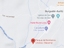
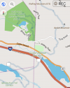
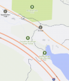
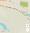
Thanks Doug, you've prodded me into examing this. I have five mapping apps that use Open Street Map data on my Android. Additionally there is IGN's Mapas de Espana and, of course, Google Maps. I really only use Google, Wikiloc and OsmAnd and the rest are used for providing information on the forum. I've downloaded maps for Massachusetts and neighboring New Hampshire and I don't usually keep Spain maps on my phone for them but I do have a few for OsmAnd use. So what I did was look at Burgette with OsmAnd and with Mapas de Espana to compare how each displays the Camino and the GR 11 trans-Pyrennes trail. Then for the five apps using OSM data compare their showing the area in Massachusetts where the Appalachian Trail crosses the Massachusetts Turnpike (I 90) on a pedestrian overpath. FYI, this happens in the town of Becket almost at the town line with Lee. Note that although the apps use the same OSM data they display the data differently.

First is OsmAnd in Burgette. You see trails marked but, additionally, the major trails of the Camino and the GR 11 are highlighted and marked with icons.
Screenshot_20230207-163126.png

Mapas de Espana has only red scallop shell icons for the Camino. It's a topographic map though so there are contour lines. If you load your own GPS tracks you will see those clearer.
Screenshot_20230207-170613.png

FYI, here's Google Maps.
Screenshot_20230207-190333.png

Now going to the Appalachian Trail here's OsmAnd. You can see a short trail that is marked with intermittent short lines but the major hiking trails aren't marked this way, they are shown highlighted though. The AT is also marked with a square white icon. In New Hampshire the AT and other major trails are marked similarly but the boxes have AT or initials of the trail's name in them. It looks like someone forgot to do the same for Massachusetts.
Screenshot_20230207-165255.png

Now for another often recommended app Maps.me. Things are a mess here. The trail is shown but not highlighted or marked with icons. You see AT names in a place where it doesn't exist, the dark green area, and for access trail signs, the i symbols. The best that we have is AT Corridor.
Screenshot_20230207-165654.png

Organic Maps is a software fork off of Maps.me that has better privacy. It's display here is much the same as it's mama. If you do some zooming and tracking it's a bit better. Anyway, although you could get lost on the maps you won't on the ground; the AT is well marked with white blazes.
Screenshot_20230207-163731.png

Wikiloc also doesn't do a terrific job pointing out the AT. With zooming and tracking you can occasionally see the words "Appalachian Trail" printed next to the marked trail but there is no highlighting or icons. To be fair though the app was not designed to be used as a general map of an area. It was designed to highlight a track downloaded by a user.
Screenshot_20230207-164418.png

Next and last is Mapy.cz which is somehow associated with Windy Maps (maybe a fork or a rebranding). I really like it's display. Well used trails are marked like other trails but marked as special by a solid red line next to the trail marking. It doesn't have icons and, like the previous three apps, it only names the trail here and there with tracking and zooming but that red highlighting line makes the AT easy to follow anyway.
Screenshot_20230207-163348.png
 
A selection of Camino Jewellery
Thanks Doug, you've prodded me into examing this. I have five mapping apps that use Open Street Map data on my Android. Additionally there is IGN's Mapas de Espana and, of course, Google Maps. I really only use Google, Wikiloc and OsmAnd and the rest are used for providing information on the forum. I've downloaded maps for Massachusetts and neighboring New Hampshire and I don't usually keep Spain maps on my phone for them but I do have a few for OsmAnd use. So what I did was look at Burgette with OsmAnd and with Mapas de Espana to compare how each displays the Camino and the GR 11 trans-Pyrennes trail. Then for the five apps using OSM data compare their showing the area in Massachusetts where the Appalachian Trail crosses the Massachusetts Turnpike (I 90) on a pedestrian overpath. FYI, this happens in the town of Becket almost at the town line with Lee. Note that although the apps use the same OSM data they display the data differently.

First is OsmAnd in Burgette. You see trails marked but, additionally, the major trails of the Camino and the GR 11 are highlighted and marked with icons.
View attachment 141235

Mapas de Espana has only red scallop shell icons for the Camino. It's a topographic map though so there are contour lines. If you load your own GPS tracks you will see those clearer.
View attachment 141236

FYI, here's Google Maps.
View attachment 141237

Now going to the Appalachian Trail here's OsmAnd. You can see a short trail that is marked with intermittent short lines but the major hiking trails aren't marked this way, they are shown highlighted though. The AT is also marked with a square white icon. In New Hampshire the AT and other major trails are marked similarly but the boxes have AT or initials of the trail's name in them. It looks like someone forgot to do the same for Massachusetts.
View attachment 141238

Now for another often recommended app Maps.me. Things are a mess here. The trail is shown but not highlighted or marked with icons. You see AT names in a place where it doesn't exist, the dark green area, and for access trail signs, the i symbols. The best that we have is AT Corridor.
View attachment 141239

Organic Maps is a software fork off of Maps.me that has better privacy. It's display here is much the same as it's mama. If you do some zooming and tracking it's a bit better. Anyway, although you could get lost on the maps you won't on the ground; the AT is well marked with white blazes.
View attachment 141240

Wikiloc also doesn't do a terrific job pointing out the AT. With zooming and tracking you can occasionally see the words "Appalachian Trail" printed next to the marked trail but there is no highlighting or icons. To be fair though the app was not designed to be used as a general map of an area. It was designed to highlight a track downloaded by a user.
View attachment 141241

Next and last is Mapy.cz which is somehow associated with Windy Maps (maybe a fork or a rebranding). I really like it's display. Well used trails are marked like other trails but marked as special by a solid red line next to the trail marking. It doesn't have icons and, like the previous three apps, it only names the trail here and there with tracking and zooming but that red highlighting line makes the AT easy to follow anyway.
View attachment 141243
@Rick of Rick and Peg, thank you for going to this effort, and confirming both that OSM data sets in different apps does include walking and cycling track layers, and pointing to the different display styles that different apps adopt for those tracks. I find that different apps use different styles for other mapping elements as well, not just walking tracks.

I suspect that the IGN data set is different again. I recall seeing that shell symbol on other IGN mapping, particularly some of their raster mapping, but it was some time ago. The current IGN product seems to have have switched to vector based mapping, but I cannot confirm that.

Once again, great effort. Thank you.
 
I have used maps.me on the Norte and Mozarabe, it works fine. Zoom in to any area of a map and the app will request you to download the appropriate map. Do this before you leave home. On a days use this app does not run down your phones battery either. If you wanr to be really fully planned, put the albergues on the map also.
Im doing the Portuguese coastal in April and will use maps.me.
Good Luck
That is fine for people who have the know how to load routes into the app. Those who don't know how to do it might still find a camino app with downloadable maps for offline use to be much easier. I am kind of in between - not a beginner at making routes for offline use - but still have a lot to learn.
 
That is fine for people who have the know how to load routes into the app. Those who don't know how to do it might still find a camino app with downloadable maps for offline use to be much easier. I am kind of in between - not a beginner at making routes for offline use - but still have a lot to learn.
If you are not careful you might soon find yourself one of the more knowledgeable interlocutors on this, and readily able to contribute good advice on GPS matters!
 
Ideal sleeping bag liner whether we want to add a thermal plus to our bag, or if we want to use it alone to sleep in shelters or hostels. Thanks to its mummy shape, it adapts perfectly to our body.

€46,-
There are a couple of useful map comparison tools, though they're probably connected, available which you may find useful. Geofabrik and Bbbike Bbbike has a far larger choice of maps. Now I/ we should investigate which maps are used by the popular apps. Enjoy.
 
Thanks Doug, you've prodded me into examing this. I have five mapping apps that use Open Street Map data on my Android. Additionally there is IGN's Mapas de Espana and, of course, Google Maps. I really only use Google, Wikiloc and OsmAnd and the rest are used for providing information on the forum. I've downloaded maps for Massachusetts and neighboring New Hampshire and I don't usually keep Spain maps on my phone for them but I do have a few for OsmAnd use. So what I did was look at Burgette with OsmAnd and with Mapas de Espana to compare how each displays the Camino and the GR 11 trans-Pyrennes trail. Then for the five apps using OSM data compare their showing the area in Massachusetts where the Appalachian Trail crosses the Massachusetts Turnpike (I 90) on a pedestrian overpath. FYI, this happens in the town of Becket almost at the town line with Lee. Note that although the apps use the same OSM data they display the data differently.

First is OsmAnd in Burgette. You see trails marked but, additionally, the major trails of the Camino and the GR 11 are highlighted and marked with icons.
View attachment 141235

Mapas de Espana has only red scallop shell icons for the Camino. It's a topographic map though so there are contour lines. If you load your own GPS tracks you will see those clearer.
View attachment 141236

FYI, here's Google Maps.
View attachment 141237

Now going to the Appalachian Trail here's OsmAnd. You can see a short trail that is marked with intermittent short lines but the major hiking trails aren't marked this way, they are shown highlighted though. The AT is also marked with a square white icon. In New Hampshire the AT and other major trails are marked similarly but the boxes have AT or initials of the trail's name in them. It looks like someone forgot to do the same for Massachusetts.
View attachment 141238

Now for another often recommended app Maps.me. Things are a mess here. The trail is shown but not highlighted or marked with icons. You see AT names in a place where it doesn't exist, the dark green area, and for access trail signs, the i symbols. The best that we have is AT Corridor.
View attachment 141239

Organic Maps is a software fork off of Maps.me that has better privacy. It's display here is much the same as it's mama. If you do some zooming and tracking it's a bit better. Anyway, although you could get lost on the maps you won't on the ground; the AT is well marked with white blazes.
View attachment 141240

Wikiloc also doesn't do a terrific job pointing out the AT. With zooming and tracking you can occasionally see the words "Appalachian Trail" printed next to the marked trail but there is no highlighting or icons. To be fair though the app was not designed to be used as a general map of an area. It was designed to highlight a track downloaded by a user.
View attachment 141241

Next and last is Mapy.cz which is somehow associated with Windy Maps (maybe a fork or a rebranding). I really like it's display. Well used trails are marked like other trails but marked as special by a solid red line next to the trail marking. It doesn't have icons and, like the previous three apps, it only names the trail here and there with tracking and zooming but that red highlighting line makes the AT easy to follow anyway.
View attachment 141243
It is possible to change how your own tracks or tracks that you edit are displayed. Colours and symbols are part of the data.
 
It is possible to change how your own tracks or tracks that you edit are displayed. Colours and symbols are part of the data.
You can overwrite the GPS track's values with OsmAnd, but I think not with Maps.me.

OsmAnd remembers GPS tracks that it has displayed on your behalf. You can choose which of these you want displayed and how to display them (but only as a group, not individually Individually is possible, see my post below). You can chose the tracks' boldness and select from some solid colors or some translucent colors if you prefer a highlighting look. You do this by selecting Appearance at the top of the track list for boldness and then again for color.

Hamburger -> Configure map -> Tracks
 
Last edited:
Ideal sleeping bag liner whether we want to add a thermal plus to our bag, or if we want to use it alone to sleep in shelters or hostels. Thanks to its mummy shape, it adapts perfectly to our body.

€46,-
I find that different apps use different styles for other mapping elements as well, not just walking tracks.

A week or two ago I did something similar by saving snapshots of a portion of Concord, Massachusetts for my apps that use OSM data. That map section displays a variety of roads, trails, buildings and both urban and rural environments. I am saving them for a discussion of apps though. On this thread I am trying to stay focused on tracks.

I suspect that the IGN data set is different again. I recall seeing that shell symbol on other IGN mapping, particularly some of their raster mapping, but it was some time ago. The current IGN product seems to have have switched to vector based mapping, but I cannot confirm that.

I don't think that IGN as a government agency would want to trust OSM for their data for anything other than tracks of the caminos. My previous version of IGN's Mapas de España did have an easy way of adding tracks like the caminos from other internet sites. I deleted the app sometime ago but reinstalled it recently and it appears to be much different. I haven't seen the adding tracks ability yet (of course if you have tracks already you can open them indicating that you want IGN to be the app to do it with). With the older version having a basic manual of 100 pages in Spanish and not being very useful outside Spain I'm not going to be exploring its advanced features for awhile. Really I only used it on the Camino Catalan in the Pyrenees to view the contour lines using Wikiloc and OsmAnd for navigation.

Once again, great effort. Thank you.

😊
Thanks, but I've got to do some serious posts to make up for the ones that I do to amuse.
 
OsmAnd remembers GPS tracks that it has displayed on your behalf. You can choose which of these you want displayed and how to display them (but only as a group, not individually).

Nope. I was wrong. In OsmAnd you can modify the appearance of a single track. Let's say you have a number of tracks recorded in a local park and the tracks really don't show up well with all the other trails available. Now suppose you encounter someone in the park who is interested in walking one. You could use the method of highlighting all your tracks by the method I described in my post above. You show them to your new friend and after a bit of discussion you want to show the one track you recommend.

Here's how. Zoom in to easily show the track and then click on a location along the track. A popup window will appear at the bottom of the screen showing details about the track. Choose the painter's palette and a menu for changing the appearance of that track. Scroll in that bottom window to see everything.

Instead of clicking the palette you could click the Options selection and see the palette among the other many things you can do with the track or the GPS file containing the track data.
 
You can overwrite the GPS track's values with OsmAnd, but I think not with Maps.me.

OsmAnd remembers GPS tracks that it has displayed on your behalf. You can choose which of these you want displayed and how to display them (but only as a group, not individually Individually is possible, see my post below). You can chose the tracks' boldness and select from some solid colors or some translucent colors if you prefer a highlighting look. You do this by selecting Appearance at the top of the track list for boldness and then again for color.

Hamburger -> Configure map -> Tracks
I really meant that the appearance of tracks is defined within the XML data.

One of the issues is that the GPX standard doesn't have standards for how data will appear (how thick the line is, what colour, continuous vs dotted line and so on) but being XML the standard allows for extensions and so the author's of each mapping program design their own characteristics. This use of extensions is also why exporting and importing tracks into other mapping programs causes them to lose the attributes that they were created with.

If a mapping tool does not allow people using the program to change the appearance of individual files then that means that the authors did not want to implement an extension to allow for this.

OSMAnd does allow for this as you have noted but it mostly does it by defining a set of track types (pedestrian, cyclist, mountain bike, automobile and others) and then allowing users to configure how these various groups appear. If you know what you are doing then if you want a particular hiking track to stand out you can define it as an otherwise unused type and then configure that type.

If you want to go even deeper and you understand XML schemas then you could theoretically create your own new type of track with whatever appearance attributes that you want.

Here is a screenshot of the start of a GPX file that I just had hanging around, it happens to be a track provided by @VNwalking and she used OSMAnd to create the track.

Screenshot_20230213-011223.png

At the start of the file you can see that they use the standard schema at http://www.topografix.com/GPX/1/1/gpx.xsd and then they point to their own "pedestrian" extension to define the appearance
Code:
<extensions>
    <osmand:profile>pedestrian</osmand:profile>
        <osmand:trkpt_idx>0</osmand:trkpt_idx>
      </extensions>

At the very end of the file extensions are again used to give the required appearance.
Screenshot_20230213-012823.png

Screenshot_20230213-012856.png

Screenshot_20230213-012910.png
 
A selection of Camino Jewellery
Nope. I was wrong. In OsmAnd you can modify the appearance of a single track. Let's say you have a number of tracks recorded in a local park and the tracks really don't show up well with all the other trails available. Now suppose you encounter someone in the park who is interested in walking one. You could use the method of highlighting all your tracks by the method I described in my post above. You show them to your new friend and after a bit of discussion you want to show the one track you recommend.

Here's how. Zoom in to easily show the track and then click on a location along the track. A popup window will appear at the bottom of the screen showing details about the track. Choose the painter's palette and a menu for changing the appearance of that track. Scroll in that bottom window to see everything.

Instead of clicking the palette you could click the Options selection and see the palette among the other many things you can do with the track or the GPS file containing the track data.
But this will only keep its appearance attributes if it is imported into OSMAnd
 
The one from Galicia (the round) and the one from Castilla & Leon. Individually numbered and made by the same people that make the ones you see on your walk.
They are up-to-date and contain many points of interest (fountains, hostels, bars/restaurants).
That reminded me to say that the OSMand app allows you to display waypoints that have been collected from Wikipedia articles. When you click on the waypoint you get to read about the place. I've written about this with more detail in this post https://www.caminodesantiago.me/com...urney-culture-and-history.75029/#post-1033461


❓How to ask a question

How to post a new question on the Camino Forum.

Most read last week in this forum

From the Camino Francis 2023. The verdict is still out!
Hi All Currently prepping for my Camino - Arles to . . . ? possibly to Compostella. The last time, I had a fitbit, and my phone for maps. I have since ditched the fitbit for an Apple watch, but...
Hi all. Apologies for another footwear question, but I'm interested in hearing what experiences people have had wearing waterproof socks for long periods on rainy days. I bought a pair of cheap...
I need to call a company in the UK from the US regarding some travel arrangements for my next walk. Has anyone used and can recommend international calling cards which would be cheaper than my...
I wore Brooks Ghost on my camino last year. I loved them but they're worn out now so I bought a new pair. They're Ghost 16. I don't know what my old pair were but I bought them in 2023 so I guess...

Featured threads

❓How to ask a question

How to post a new question on the Camino Forum.

Forum Rules

Forum Rules

Camino Updates on YouTube

Camino Conversations

Most downloaded Resources

Featured threads

This site is run by Ivar at

in Santiago de Compostela.
This site participates in the Amazon Affiliate program, designed to provide a means for Ivar to earn fees by linking to Amazon
Official Camino Passport (Credential) | 2024 Camino Guides
Back
Top