• Remove ads on the forum by becoming a donating member. More here.

Search 74,075 Camino Questions

France IGN Maps "GPS ready" - what does it mean?

BobM

Veteran Member
Time of past OR future Camino
V Frances; V Podensis; V Francigena; V Portugues; V Francigena del Sud; Jakobsweg. Jaffa - Jerusalem
I have just bought IGN maps for the Via Francigena (Top 100 Series, 1:100,000).

The maps are gridded at 5km intervals and every second grid line is labelled. For example, one vertical grid line on the Map 101 is labelled "GPS 430".

There are also the usual latitude and longitude lines, but they don't agree with the GPS grid lines. For example, the logitude line right next to the "GPS 430" line is 2degrees.

What does all this mean?

Puzzled :?

Bob M
 
Holoholo automatically captures your footpaths, places, photos, and journals.
Bob, those are UTM grid lines. Many people with gps devices set them to use utm rather than lat & long. Search and rescue units use utm. The advantage for me is that I can look at a decimal utm reading on my gps, and easily estimate where I am on my paper map, since my map utm grid lines are a decimal distance apart, rather than 12ths or 60ths or whatever lat & long is. Trust me, it's easier.
 
That makes sense. I did not realise you could choose different coordinate systems on a GPS unit. I must check if my car GPS has a UTM option. It certainly has an option for decimal degrees, rather than conventional "degrees-minutes-seconds"

Thx for the explanation.

Bob M
 
3rd Edition. More content, training & pack guides avoid common mistakes, bed bugs etc
I did a bit more research by googling UTM coordinates. There are many useful websites, but here is one that is good for GPS novices like me. There are tutorials & a whole lot of good stuff.

http://www.maptools.com/UsingUTM/

The big plus is being able to very easily plot UTM coords on a "GPS ready" map.

If I take a GPS unit on the VF, it will be to check my position on the paper IGN maps when navigating away from the guidebook suggested route. The 1:100,000 IGN maps are pretty good at 1cm = 1km, but they lack detail for very accurate navigation away from guidebook routes. That's where UTM will be a blessing on UTM-gridded maps.

Here is another Garmin-friendly website that discusses navigating with tracks that I found useful:
http://gpstracklog.com/2010/07/navigati ... helds.html

BTW, I checked my automotive Garmin Nuvi & it does not seem to have UTM as a coordinates option - unless it is buried away in some obscure setting that I can't find. Garmin Hiking GPS units like the Dakota 20 apparently do.

Rgds

Bob M
 
I am planning to start the Via Francigena in September. I understand it is not well signposted in France. I would like to take a GPS handheld to help us to stay on course. Others have spoken highly of the Garmin Dakota 20 and the Garmin Oregon 450.The challenge to this GPS novice is to get the maps to load onto the device (Cdn topo maps are available in Canada - have not yet found a source for the French IGN maps.) and to then load the GPZ files that will put the VF trace on the IGN map.
I would love to hear from others who have used a GPS on the VF route in France and any advice/guidance they might offer especially on loading and using IGN maps and where they obtained them in digital format.
 
DavidCanadian said:
...
I would love to hear from others who have used a GPS on the VF route in France and any advice/guidance they might offer especially on loading and using IGN maps and where they obtained them in digital format.

David,

Try this web site for IGN digital maps. >> http://www.memory-map.co.uk/maps_france_onland_top25.htm

Also check out the web site of fellow Forum member Peter Robins who has done a great deal of work with and on digital maps. Here is that link >> http://maps.peterrobins.co.uk/

Good luck with your research and Buen Camino!

Margaret
 
...and ship it to Santiago for storage. You pick it up once in Santiago. Service offered by Casa Ivar (we use DHL for transportation).
Thank-you Margaret,

The Memory-Map site seems to be what I need. Have you used a GPS on your Caminos? This will be our first Camino that is not in the direction of Santiago.

David
 
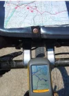
I used those UTM gridlines all the time until the gps units became so good at loading a long track log. Now I have the entire trail on the gps screen and a little triangle which tells you where you are on it.

If your map has the trail---most of them are on the IGN maps--you'll instantly know where you are by the shape of the track.

Look at the whole picture so you see the map and the screen---the map has UTM grids 18 19 20 etc, which are useful as kilometer scales, but the track on the map and the GPS match up so well that looking at the UTM or lat long numbers is not needed.
 

Attachments

  • gps.webp
    gps.webp
    96.5 KB · Views: 1,472

❓How to ask a question

How to post a new question on the Camino Forum.

Most read last week in this forum

Greetings all While travelling from Camponaraya to Cacabelos I stumbled this nice little park area with benches and a BBQ area, right past the Wine factory and next to a Car Wash and Gas Station...
I saw a video with a rather harsh criticism of a small, municipal albergue on one of the less traveled caminos. They paid 9€. I thought: What does it cost a small municipality to renovate and keep...
On my last Camino (2023) I noticed that there were lots of tourists. It reminded me of a couple of quotes that I have read since my first Camino (2015) “A tourist demands, a pilgrim is grateful”...
"A complete guide to the world's greatest pilgrimage"[sic] by Sarah Baxter. In a British newspaper, The Telegraph. A right wing daily that does print interesting articles and essays...
Day 42 Week 6 460km walked (give or take) Today I had a revelation, an epiphany and a Divine Intervention... all in one day. Today the exreme pain in my soul is dissipating some... healed by the...
I've been trying to figure out how to use the Gronze app and as a first step I need to translate into English - I searched topics on the Forum, thought I found what I was looking for, and Yay! I...

Featured threads

❓How to ask a question

How to post a new question on the Camino Forum.

Featured threads

Forum Rules

Forum Rules

Camino Updates on YouTube

Camino Conversations

Most downloaded Resources

This site is run by Ivar at

in Santiago de Compostela.
This site participates in the Amazon Affiliate program, designed to provide a means for Ivar to earn fees by linking to Amazon
Official Camino Passport (Credential) | 2024 Camino Guides
Back
Back
Top