Thanks
@C clearly. A nicely presented and interesting piece.
It is something I have thought of quite seriously at times. My choice is generally for the "roads less travelled" and while I enjoy company I am usually walking by myself.
A couple of specific times I have acknowledged at least to myself that if I fell and broke a leg I would find it very hard to make contact with anyone, without a mobile signal. Of course as time goes by, mobile signals continue to spread but they are not everywhere by any means. And in a weak moment, when falling, I suppose I could lose my phone (especially as it is likely in the kind of place where I am reliant on GPX guidance and have it in my hand) and see it hurtle down a mountainside.
Specifically on some stages of the Baztan route in French-Spanish Basque country there are some 'lonely places.'
And very definitely a few days while walking the Via Egnatia along the road towards Jerusalem. There are hair-raising places in the mountains in Albania, specifically between Mirakë and Dardhë (I mean hair-raising for an average hiker - maybe not for an experienced mountaineer) and then in North Macedonia especially between Ohrid and Resen.
I think it is good to at least recognise and admit this to oneself. Strictly speaking I have no dependants. If something very serious were to befall me it would be wrong to say "I never thought it could happen" but it would not in any practical way be the end of
anyone else's world. I have discussed this before on the forum. And I have revealed that I usually have secreted away in my pack, separate from routine
barras energeticas, cheap chocolate and nuts, some
superior chocolate - to make a comforting last meal.
I have a new Apple Watch (other brands are available) and it is a bit 'anxious'. If I wear it in the shower it tells me I am endangering my hearing with too loud noises. And once or twice if I make an animated gesture with my hands it tells me that it suspects I have had a fall.
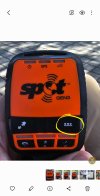
However, more seriously it does have fall and crash detection and can make an SOS call to a satellite if I am out of range of wifi or phone signal.
I guess I should devote an afternoon to finding out how to use it.
Has anyone had any experience with it? Or other similar devices?
I should add that none of this has ever caused me to lose any sleep.


")


