- Time of past OR future Camino
- First: Camino Francés 2002; most recent: Norte/Primitivo 2019
Hi all,
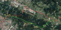
I'm getting ready to head back out to the Norte/Primitivo at the end of this month with a new group of high schoolers. (Don't worry--we won't be anywhere near the municipal in Azofra!) I'm looking forward to trying out a few new approaches, as always. One of the things I've been focused on lately is that highway section between Larrabetzu and Zamudio, between Gernika and Bilbao. I've always felt like there must be a better option. Maybe I've found one?

This isn't a "real" route--this is me messing around in my gps software, but I think it's viable, and I'm going to give it a test run in a few weeks. But, if anyone's passing through earlier and wants to avoid the highway, here's what you need to know:
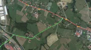
Leaving Larrabetzu, follow the Norte out of town. After passing a football field and a couple of dead-end left turns, you'll arrive at a more significant left turn (where the green line starts below). Take this, forking right then left to cross the expressway.

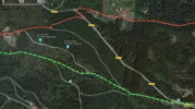
Follow that road as it winds around a small golf course and the Asador Horma Ondo. Shortly after passing the golf course, you've got to watch for a sharp right turn off the road, on to a track. From this point on, I believe the walk is almost entirely off-road. Probably the trickiest intersection to manage is at the end of this map, in the bottom-left, where it appears the route splits three ways and it's important to take the middle fork. No harm done if you take the left option. If you take the right option, though... it's going to be a longer day.

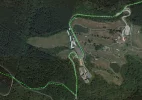
Soon after that point, the trail merges with a larger dirt road, continuing westward parallel to the BI-3732, intersecting it in places (like at the Vivero Taberna) and then eventually crossing it just before arriving at Monte Avril:

You can see that point in the bottom-right (note that I've skipped a good chunk of the map to arrive at this point). The trails start splitting up a lot more here, as you get into the Avril recreational area. You can see the official Norte coming in from above (the red line).
Anyway, according to the software, this walk (from just after Larrabetzu to Monte Avril) takes 9.7km, in comparison to the 10.5km on the official route. By my best guess, roughly 1/3 of that is paved and 2/3 is unpaved. I think there may be some good views--it looks like the main dirt road is up near the ridge line. There are a couple of opportunities for food/drink along the way, depending upon what time you reach them.
I'll give it a go and let you know if the reality is on par with the digital promise.
Dave
I'm getting ready to head back out to the Norte/Primitivo at the end of this month with a new group of high schoolers. (Don't worry--we won't be anywhere near the municipal in Azofra!) I'm looking forward to trying out a few new approaches, as always. One of the things I've been focused on lately is that highway section between Larrabetzu and Zamudio, between Gernika and Bilbao. I've always felt like there must be a better option. Maybe I've found one?

This isn't a "real" route--this is me messing around in my gps software, but I think it's viable, and I'm going to give it a test run in a few weeks. But, if anyone's passing through earlier and wants to avoid the highway, here's what you need to know:
Leaving Larrabetzu, follow the Norte out of town. After passing a football field and a couple of dead-end left turns, you'll arrive at a more significant left turn (where the green line starts below). Take this, forking right then left to cross the expressway.

Follow that road as it winds around a small golf course and the Asador Horma Ondo. Shortly after passing the golf course, you've got to watch for a sharp right turn off the road, on to a track. From this point on, I believe the walk is almost entirely off-road. Probably the trickiest intersection to manage is at the end of this map, in the bottom-left, where it appears the route splits three ways and it's important to take the middle fork. No harm done if you take the left option. If you take the right option, though... it's going to be a longer day.

Soon after that point, the trail merges with a larger dirt road, continuing westward parallel to the BI-3732, intersecting it in places (like at the Vivero Taberna) and then eventually crossing it just before arriving at Monte Avril:

You can see that point in the bottom-right (note that I've skipped a good chunk of the map to arrive at this point). The trails start splitting up a lot more here, as you get into the Avril recreational area. You can see the official Norte coming in from above (the red line).
Anyway, according to the software, this walk (from just after Larrabetzu to Monte Avril) takes 9.7km, in comparison to the 10.5km on the official route. By my best guess, roughly 1/3 of that is paved and 2/3 is unpaved. I think there may be some good views--it looks like the main dirt road is up near the ridge line. There are a couple of opportunities for food/drink along the way, depending upon what time you reach them.
I'll give it a go and let you know if the reality is on par with the digital promise.
Dave


