-
 ⚠️ Emergency contact in Spain - Dial 112 and AlertCops app. More on this here.
 -
Remove ads on the forum by becoming a donating member. More here.
Search 74,075 Camino Questions
You are using an out of date browser. It may not display this or other websites correctly.
You should upgrade or use an alternative browser.
You should upgrade or use an alternative browser.
Arrows on the VdlP
- Thread starter El Muto
- Start date
A selection of Camino Jewellery
patgreen
Member
In general I found it well marked and yes there are arrows. I do seem to recall some confusion on the Sevilla - Guillena leg. I think it was just that there was a choice of routes and on one of them you had to walk through some water. Not difficult or fast flowing.I will start the Via de la Plata at the beginning of May.
I would like to hear from you whether it is well marked and whether you can see the arrows(flechas) well.
A big help for most of the Via de la Plata is that you just go north.
Corned Beef
Veteran Member
- Time of past OR future Camino
- 2024 Portuguese / VF (South) / VF GSB Pass (Done)
I had a rant about signs on the VDLP. I travelled over the first section a couple of weeks ago.
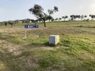
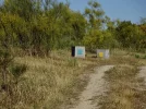
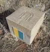
There are the yellow flechas in some places. Some are painted and there are some plastic ones. But my main (corned) beef is with the grey marble cubes with yellow squares on them as they don't actually give you a direction. Some cubes have had the flechas painted on but most haven't.
When you get into the scrub you have more chance of missing them, as I did, even with GPS. There is an additional confusion of small marble pyramids with VP on them. These are NOT directional markers but rather they mark the limit of the farmers' land so you have to be between two of them to be on the right track. Have the GPS track on your phone - Windy or something similar.
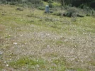
Some pics
Attachments
Holoholo automatically captures your footpaths, places, photos, and journals.
- Time of past OR future Camino
- 2023
I cycled the VDLP in 2019 and have no real complaints about the markings of this Camino. Cities can be a bit trickier due to all of the competing distractions, but in general, and even at bike speed, following this camino was no more difficult than the others that I have done. I did have the Windy Maps on my phone with reginal maps downloaded that was helpful. Buen Camino!
JohnMcM
Veteran Member
- Time of past OR future Camino
- Some, and with luck, some more.
I think you will be pleasantly surprised at how well the VdLP is marked. It is not as frequently marked as, for example, the Frances route but I found the marking more than adequate. This link below may give you a bit peace of mind.
Also, to make life even easier, you are pretty much heading North all day, so in the morning the sun should be on your right and in the afternoon on your left.
Buen (flecha-findin) Camino
Also, to make life even easier, you are pretty much heading North all day, so in the morning the sun should be on your right and in the afternoon on your left.
Buen (flecha-findin) Camino
Anniesantiago
Veteran Member
- Time of past OR future Camino
- 2006 to date: Over 21 Caminos. See signature line
We found it quite well marked.
Ideal pocket guides for during & after your Camino. Each weighs only 1.4 oz (40g)!
DoughnutANZ
Ka whati te tai ka kai te tōreapango
- Time of past OR future Camino
- 2019, 2023, 2024, 2025, 2026, 2027 & 2028.
Um, isn't that the other way around?Also, to make life even easier, you are pretty much heading North all day, so in the morning the sun should be on your left and in the afternoon on your right.
If I am walking North then in the morning the sun will be on my right and in the afternoon on my left.
- Time of past OR future Camino
- 2024 Aragones, Madrid, Portugues Coastal
Just keep walking north. I just finished it and never had a problem at all. Of course the most complicated is in the cities.
- Time of past OR future Camino
- VdLP-Sanabres-Fisterra '15; Levante-Invierno '19
Even though theoretically you are heading North, you will find yourself facing East most mornings when you leave towns walking into a sunrise. Just to confuse things further.Um, isn't that the other way around?
If I am walking North then in the morning the sun will be on my right and in the afternoon on my left.
Train for your next Camino on California's Santa Catalina Island March 16-19
maritr
New Member
- Time of past OR future Camino
- Some since 2002 and hopefully more to come
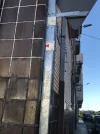
Generally well marked in my opinion, but you have to keep your eyes open! These ones are very small. The Wise Pilgrim app helped me a lot last time I walked. Especially the online map.
Buen Camino!
Marit (via de la plata lover)
F
Former member 98118
Guest
But my main (corned) beef is with the grey marble cubes with yellow squares on them as they don't actually give you a direction. Some cubes have had the flechas painted on but most haven't.
The cubes actually do show you a direction. On each cube there is a symbol of the Arch of Caparra on the top and if you are on the way to Santiago, you always go up this horseshoe. Tha cubes can be found in Extremadura only.
The yellow and green rectangles on the side of the cubes are not supposed to show you the direction of walking, they can be on any side of the cube. Because Via de la Plata doesn't have one direction, you can walk it south to north or north to south. The Camino to Santiago coincides with VdlP but is not the same thing. Via de la Plata goes to Astorga but not Santiago.
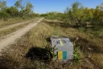
Added: The green stripe or square means that you are on the original Via de la Plata, based on historical evidence. The yellow stripe or square means that you are on VdlP as it has been marked in present time, to avoid crossing private property. In most part, green and yellow stripes go together, like in the picture below, but not always.
Last edited by a moderator:
The one from Galicia (the round) and the one from Castilla & Leon. Individually numbered and made by the same people that make the ones you see on your walk.
- Time of past OR future Camino
- Too many and too often!
I left Extremadura a couple of days ago and I really miss the cubesThe yellow and green rectangles on the side of the cubes are not supposed to show you the direction of walking, they can be on any side of the cube.
frjuliangreen
Member
- Time of past OR future Camino
- Camino Inglés (2018)
Camino Portugués (2019)
Vía de la Plata/Camino Sanabrés (2020)
Very well marked. I think there was only one place which wasn't so good and that is on the highest section South of Salamanca - between Fuenterroble de Salvatierra and San Pedro Rozados I ended out on a pig farm on a parallel road to the Camino. It obviously happens a lot a the pig farm has signs in various languages warning pilgrims not to take a short cut through the farm. Backtracking added quite a bit to an already lengthy stage. But in general the arrows are good. Beware, in the early stages, a few opportunists painting their own arrows taking you off the Camino to their shop or bar. It's as well to read the route indications in a guide so you know what to expect on any day.I will start the Via de la Plata at the beginning of May.
I would like to hear from you whether it is well marked and whether you can see the arrows(flechas) well.
frjuliangreen
Member
- Time of past OR future Camino
- Camino Inglés (2018)
Camino Portugués (2019)
Vía de la Plata/Camino Sanabrés (2020)
I hated those cubes. To each their ownI left Extremadura a couple of days ago and I really miss the cubesThe direction marker on top using the Caparra arch is very helpful except where some vandal has toppled the cube into a ditch
They also make an excellent stool. The marking system in Castille Y Leon is different but clear enough if you pay attention. It is important to realise that every province has its own marking system but most often the path is obvious. If you are very anxious then downloading the Maps.me app, a gps track of the route and the relevant offline map data will give you confidence. In towns it is always easy to lose markers and I usually make a note of where the Camino leaves town and just make my own way there by the most obvious route.
A selection of Camino Jewellery
- Time of past OR future Camino
- I´ve got Camino plans until 2042,
- or till I fall flat on my face, whichever comes first !!
they were perfect when lacing your boots, sitting for a while on a plane surface, or for the odd lunch bite....
- Time of past OR future Camino
- CF (2014)
VDLP / C.Sanabres (2017)
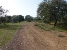
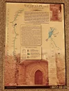
I was delighted to finally come upon a poster (first image) that explained the symbolisms of the cubes. With my new-found knowledge, they became more meaningful for me. The second image shows the yellow "passable" route follows the dirt road while the green "authentic/historical" route heads off into the weeds. When both yellow and green tiles are affixed to the cube, it shows that the passable route IS the historical route.Added: The green stripe or square means that you are on the original Via de la Plata, based on historical evidence. The yellow stripe or square means that you are on VdlP as it has been marked in present time, to avoid crossing private property. In most part, green and yellow stripes go together, like in the picture below, but not always.
It is interesting to me that there is a LOT of history shared throughout Extramadura on information markers along the route. I'm guessing the Extramadura Governing folks chose to use, instead of yellow arrows, a directional marker with more historical significance to include the striking Roman Arco de Cáparra on the top of the cube.
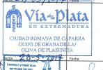
And speaking of the Arco de Cáparra, if you arrive there before 2pm or after 5pm, head on into the ruins to have a look around. At the visitor's center, you can get your credential stamped with their sello which I found particularly special.
Attachments
Last edited:
- Time of past OR future Camino
- 2009-2022: CFx6, CP, VdlPx2, Mozarabe, more later.
Walking in 2012-2013, I found the marking quite well. I had no issues.
Ideal sleeping bag liner whether we want to add a thermal plus to our bag, or if we want to use it alone to sleep in shelters or hostels. Thanks to its mummy shape, it adapts perfectly to our body.
€46,-
€46,-
JohnMcM
Veteran Member
- Time of past OR future Camino
- Some, and with luck, some more.
Thanks. I must have been editing my post as you were typing yours. No harm done, your help offered and received in the spirit of the Camino.Um, isn't that the other way around?
If I am walking North then in the morning the sun will be on my right and in the afternoon on my left.
❓How to ask a question
How to post a new question on the Camino Forum.
Most read last week in this forum
Similar threads
- Replies
- 36
- Views
- 3K
- Replies
- 16
- Views
- 1K
- Replies
- 14
- Views
- 1K
- Replies
- 6
- Views
- 1K
LIVE from the Camino
Camino Sanabres 2024
- Replies
- 24
- Views
- 3K
❓How to ask a question
How to post a new question on the Camino Forum.
Most downloaded Resources
-
“All” Albergues on the Camino Frances in one pdf“All” Albergues on the Camino Frances in one pdf
- ivar
- Updated:
-
A selection of favorite albergues on the Camino FrancésFavorite Albergues along the Camino Frances
- Ton van Tilburg
- Updated:
-
Profile maps of all 34 stages of the Camino FrancesProfile maps of all 34 stages of the Camino Frances
- ivar
- Updated:


