Search 74,075 Camino Questions

An alternativo to avoid busy highway after Chantada

andycohn

Active Member
Time of past OR future Camino
See signature
Leaving Chantada this morning for our first day on the Invierno, I was appalled to see that, roughly 2k out of town, the Camino ran adjacent to a busy highway for some 3k before cutting off south towards Penasilas.

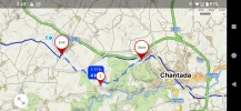
Since I HATE walking anywhere near a busy road, I stopped before proceeding and checked on mapy.cz to see if there was a more tranquil alternative.

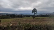
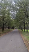
And there was! Along rural and almost completely unused paved farm tracks that were wonderfully scenic and totally serene. From the point we left the Camino until the point we rejoined it 4k later we saw exactly 5 cars, all gently moseying along. (This compared with at least 50 cars that whizzed by along the highway in the 2 minutes I was checking mapy.cz for alternatives).

Note that if you really prefer the dulcet roar of semi-trucks, you can save yourself a full 200 meters by staying on the Camino along the highway. Far be it from me to dictate your choice.

Btw, if you're staying at Hotel Vilaseco, you just stay on this alternative at the point where it hits the Camino.

Here's the track for mapy.cz fans (I'm confident someone more tech-savvy than I can convert this into gpx tracks):

Route from LU-213 to A Laxe, Chantada
Route 4 km • 1:17 h

A screenshot from mapy.cz is pasted in below, along with some photos (The Camino follows the highway, in green).

I've checked the great guidebook of @peregrina2000 and some of the wonderful threads on the forum, as well as Brierley and Wise pilgrim, and can find no mention of this possible alternative, so I offer it here.

Hope it's useful!
 

Attachments

  • Screenshot_20241024-154329.webp
    Screenshot_20241024-154329.webp
    226.3 KB · Views: 278
  • PXL_20241024_103429946.webp
    PXL_20241024_103429946.webp
    984.1 KB · Views: 52
  • PXL_20241024_092446290.webp
    PXL_20241024_092446290.webp
    1.8 MB · Views: 25
  • PXL_20241024_101551131.webp
    PXL_20241024_101551131.webp
    2.3 MB · Views: 53
Last edited:
The one from Galicia (the round) and the one from Castilla & Leon. Individually numbered and made by the same people that make the ones you see on your walk.
3rd Edition. Vital content training & pack guides avoid common mistakes, bed bugs etc
Leaving Chantada this morning for our first day on the Invierno, I was appalled to see that, roughly 2k out of town, the Camino ran adjacent to a busy highway for some 3k before cutting off south towards Penasilas.

Since I HATE walking anywhere near a busy road, I stopped before proceeding and checked on mapy.cz to see if there was a more tranquil alternative.

And there was! Along rural and almost completely unused paved farm tracks that were wonderfully scenic and totally serene. From the point we left the Camino until the point we rejoined it 4k later we saw exactly 5 cars, all gently moseying along. (This compared with at least 50 cars that whizzed by along the highway in the 2 minutes I was checking mapy.cz for alternatives).

Note that if you really prefer the dulcet roar of semi-trucks, you can save yourself a full 200 meters by staying on the Camino along the highway. Far be it from me to dictate your choice.

Btw, if you're staying at Hotel Vilaseco, you just stay on this alternative at the point where it hits the Camino.

Here's the track for mapy.cz fans (I'm confident someone more tech-savvy than I can convert this into gpx tracks):

Route from LU-213 to A Laxe, Chantada
Route 4 km • 1:17 h

A screenshot from mapy.cz is pasted in below, along with some photos (The Camino follows the highway, in green).

I've checked the great guidebook of @peregrina2000 and some of the wonderful threads on the forum, as well as Brierley and Wise pilgrim, and can find no mention of this possible alternative, so I offer it here.

Hope it's useful!
Thank you thats going in my notes for 2025
 
Why didn't I think of this - the stretch out of Chantada was a bit of an ordeal compared with the zen-like calm of most of the Invierno. Thanks, Andy.
 
Give back to the Camino. Join us from Logroño to Burgos May 30 to June 8.
Train for your next Camino on California's Santa Catalina Island March 30 to April 2
I'm a bit confused. You only walk on the LU-213 for about 100 mtrs, then turn left to walk on farm track/gravel roads for a couple of kms. Sure, the Camino runs next to the highway but you never see it because of the vegetation. Since I always walk early in the morning, I have never heard much of the cars either. The walk out of Chantada is just as peaceful as the rest of the day, I think.
 
That's interesting. Has camino been moved? In 2012 it run almost exactly on this alternative. See my wikiloc: https://www.wikiloc.com/hiking-trails/camino2012-149-chantada-rodeiro-21734719.

Another possibility is that the route on mapy.cz is not the waymarked route. I find that mapy.cz sometimes has someone's walked route that doesn't always align with the waymarks.
Indeed, that is interesting, @caminka. Your wikilocs track does line up with the alternative I sketched out. However, as of a month ago I can report that the camino now runs along or near the main road, labelled the CG-2.1. Not only does mapy.cz point you down that main road, but so, too, do the markers, along with the track from Gronze. (Exactly how busy that through road is seems to be a point of -- rather ridiculous -- contention, but it is indisputably a through road along which the speed limit is 80 kph, or more).

So it seems like the camino has moved since you walked it. The "Why" is another matter.

(And your wikilocs track will be useful to those who use that app. instead of mapy.cz. Thanks).
 
Last edited:
Train for your next Camino on California's Santa Catalina Island March 30 to April 2
Indeed, that is interesting, @caminka. Your wikilocs track does line up with the alternative I sketched out. However, I can assure you that the camino now runs along or near the main road. Not only does mapy.cz point you down the main road, but so, too, do the markers, along with the track from Gronze. (Exactly how busy that through road is seems to be a point of -- rather ridiculous -- contention, but it is indisputably a through road along which the speed limit is 80 kph, or more).

So it seems like the camino has moved since you walked it. The "Why" is another matter.

(And your wikilocs track will be useful to those who use that app. instead of mapy.cz. Thanks).
Perhaps there has been a territorial dispute and the camino had to be rerouted. Although N roads in spain usually have a small shoulder, they are not nice to walk on.
 

❓How to ask a question

How to post a new question on the Camino Forum.

Forum Zoom Chats

Join our Camino Forum Zoom chats every Tuesday. See the next one here.

❓How to ask a question

How to post a new question on the Camino Forum.

Forum Rules

Forum Rules

Camino Updates on YouTube

Camino Conversations

Most downloaded Resources

This site is run by Ivar at

in Santiago de Compostela.
This site participates in the Amazon Affiliate program, designed to provide a means for Ivar to earn fees by linking to Amazon
Official Camino Passport (Credential) | 2024 Camino Guides
Back
Top