• ⚠️ Emergency contact in Spain - Dial 112 and AlertCops app. More on this here.
  • Remove ads on the forum by becoming a donating member. More here.

Search 74,075 Camino Questions

Alternative route out of Pajares

MarieLauFlorin

Active Member
Time of past OR future Camino
See list below
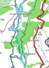
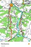
I am in Poladura de Tercia heading 14,7 kms for Pajares tomorrow. I an thinking of walking further 8 kms on this red alternative route. Anyone here who knows that route? Is it doable after the first 14,7 kms to Pajares?
 

Attachments

  • AF254FE8-9188-4F41-A32A-41A108A6B733.webp
    AF254FE8-9188-4F41-A32A-41A108A6B733.webp
    382.4 KB · Views: 60
...and ship it to Santiago for storage. You pick it up once in Santiago. Service offered by Casa Ivar (we use DHL for transportation).
If you do, make sure that you have a place to spend the night there.
I walked from Poladura to Campomanes - I wouldn't recommend that. It was the longest day that I've spent on any Camino! The distance wasn't too bad, but there were so many ups and downs in the last 12-15km or so.
 
The 2024 Camino guides will be coming out little by little. Here is a collection of the ones that are out so far.
I am in Poladura de Tercia heading 14,7 kms for Pajares tomorrow. I an thinking of walking further 8 kms on this red alternative route. Anyone here who knows that route? Is it doable after the first 14,7 kms to Pajares?
Don’t mean to be dense, but I don’t understand the map. Does the orange route stay on the other side of the valley?(by that I mean, does it stay up high rather than go down to San Miguel, across the river, and then back up again as the official route does?)

Where is this map from, it looks like a specific Salvador guide, but I haven’t seen it.

San Miguel comes after Pajares, not before as the labels suggest, unless this map is showing the split where you can go directly to San Miguel without going to Pajares. But it doesn’t look like it to me.

In any event, and like @trecile has said, the question is where you will sleep.

The private albergue in Llanos de Somerón, which is highly reviewed, is on the official camino.

One way to go further than the 14.7 to Pajares would be to continue on the official route to Llanos, which would give you 5 more kms approximately.

If you wanted a 30 km day, go to Bendueños from Poladura. It is a wonderful place.

Good luck, wish I could understand the map better because I have walked the Salvador four times and have a pretty good idea of the route.
 
If possible, I walked it in 2017, but it had very sparse signage. It is almost essential to carry GPS with the track.
Thanks so much. I will have to fix the gps issue then. The map in my Wisely app does not work properly even though I downloaded map tiles. Thanks for your advice:-)
 
If you do, make sure that you have a place to spend the night there.
I walked from Poladura to Campomanes - I wouldn't recommend that. It was the longest day that I've spent on any Camino! The distance wasn't too bad, but there were so many ups and downs in the last 12-15km or so.
That’s exactly why we have a booking in Pajares. 14,7 kms just seemed so short så we want to maybe leave the backpacks in our room when we get to Pajares and continue the 8 along the alternative route and get a car back to our room in Pajares. Then next day we can take the official orange route.
 
Ideal pocket guides for during & after your Camino. Each weighs only 1.4 oz (40g)!
Don’t mean to be dense, but I don’t understand the map. Does the orange route stay on the other side of the valley?(by that I mean, does it stay up high rather than go down to San Miguel, across the river, and then back up again as the official route does?)

Where is this map from, it looks like a specific Salvador guide, but I haven’t seen it.

San Miguel comes after Pajares, not before as the labels suggest, unless this map is showing the split where you can go directly to San Miguel without going to Pajares. But it doesn’t look like it to me.

In any event, and like @trecile has said, the question is where you will sleep.

The private albergue in Llanos de Somerón, which is highly reviewed, is on the official camino.

One way to go further than the 14.7 to Pajares would be to continue on the official route to Llanos, which would give you 5 more kms approximately.

If you wanted a 30 km day, go to Bendueños from Poladura. It is a wonderful place.

Good luck, wish I could understand the map better because I have walked the Salvador four times and have a pretty good idea of the route.
The map is the one from Wiselys app. Unfortunately that app is not very good. We want to hit Benduenos but have heard that the 30 kms there are too far. That’s why we have a booking in Pajares. Todays 14,7 kms from Poladura just seems so short now so we want to maybe leave the backpacks in our room when we get to Pajares and continue the 8 along the alternative route and get a car back to our room in Pajares. Then next day we can take the official orange route. That way we will walk both the red alternative and the orange main route.
 
I'm also confused. Twice I have walked the original way to Pajares and the albergue. This year it seems that many are walking via Llanos. Is that because of covid and the new albergue on that route?
Does it start across the road near the wooden sign for Pajares Albergue?
 
The map is the one from Wiselys app.
I'm also confused.
It's super confusing, because there are a bunch of marked routes through here:
Screenshot_20211018-160219_OsmAnd.webp
The turquoise one is the track I downloaded from the Dutch co-fraternity; the other darker blue lines are various other routes.

If you take the PR-AS96, the track on the left leaving Llanos, you end up in Benduenos (pinned, below), but that's not actually on the official route, at least according to my map:
20211018_155517.webp
 
A selection of Camino Jewellery
Even the locals get confused. The left takes you to Pájares, the right to San Miguel. The Salvador has a few variants (this is one) and has, I believe, been changed once or twice over the years. As a result, some apps and guides may be out of date. The good news is that it is very well way-marked. My advice is follow the arrows and don't rely too much on the app. If you want to stay at Bendueños (and I highly recommend that you do), you can turn off the camino at Herías.

P1000358.webp
 
Twice I have walked the original way to Pajares and the albergue. This year it seems that many are walking via Llanos.
Llanos de Somerón is on the official route.
It is the little town that is at the start of the long road walk down to Puente de Fierros. An albergue turístico opened there about two years ago and many have liked it.

If I wanted to walk beyond Pajares, I would go further on to Llanos and make it a 20 km day from Poladura.

I think that the red route on the map in the original post shows a route that goes along the same side of the valley that Pajares is on. It ends up in Puente de Fierros where it meets the official route. I’m sure it’s very pretty, since that whole area is gorgeous, and it looks like it’s off road, so it might be a nice way to spend the afternoon. Also, I think it would be all downhill since there are no more ascents from Pajares to Puente Fierro if you stay on the Pajares side of the river.

This wikiloc route looks like the sme route. And since the title of the route says “camino de san salvador” and since this most definitely isn’t the official Salvador route, it might be the same alternative.


Good luck with this. Would love to see some pictures.
 
Even the locals get confused. The left takes you to Pájares, the right to San Miguel. The Salvador has a few variants (this is one) and has, I believe, been changed once or twice over the years. As a result, some apps and guides may be out of date. The good news is that it is very well way-marked. My advice is follow the arrows and don't rely too much on the app. If you want to stay at Bendueños (and I highly recommend that you do), you can turn off the camino at Herías.

View attachment 111530
Yes, when I walked in September this year I was using the Wise Pilgrim app for tracks and found the route now is different in several places
 
3rd Edition. More content, training & pack guides avoid common mistakes, bed bugs etc
Even the locals get confused. The left takes you to Pájares, the right to San Miguel. The Salvador has a few variants (this is one) and has, I believe, been changed once or twice over the years. As a result, some apps and guides may be out of date. The good news is that it is very well way-marked. My advice is follow the arrows and don't rely too much on the app. If you want to stay at Bendueños (and I highly recommend that you do), you can turn off the camino at Herías.

View attachment 111530
I don’t think you are talking about the same split as @MarieLauFlorin described in her original post.

I think, but could be wrong, that you are talking about the split after the Puerto de Pajares where you can either go down to San Miguel, bypassing the town of Pajares, or up to the town of Pajares. Anyone who was going to stay in Llanos de Somerón and not the town of Pajares would take that route directly down to San Miguel.

The split described in the first post are two alternative ways to get to Puente de Fierros. One is the official camino — Pajares - San Miguel - Llanos de Somerón - Puente de Fierros.

And the other looks like a route that stays up on the same side of the valley as the town of Pajares and continue down to Puente de Fierros where the two routes merge. I suppose that alternative has the advantage of only having one descent (whereas when you go down to San Miguel, you thn go up to Llanos de Somerón and then back down to Puente de Fierros), so it may be an easier walk.

I hope @MarieLauFlorin will report back on how she found this alternative on the Pajares side of the river!
 
I am in Poladura de Tercia heading 14,7 kms for Pajares tomorrow. I an thinking of walking further 8 kms on this red alternative route. Anyone here who knows that route? Is it doable after the first 14,7 kms to Pajares?
So, @MarieLauFlorin,
I hope you’ve had a good walk out of Pajares. We would love to hear about how it went and what info you can give us about the “red alternative route.”
 
I had the bright idea to ask Ender, not sure why that didn’t occur to me earlier. As always, I got a prompt reply that clears up all the confusion. So here are the routes that there are between the Puerto/pass at Pajares, and Fresnedo/Puente Los Fierros

1. “official route” from the pass, which has two points at which those who are NOT going to the town of Pajares can split off and go directly to San Miguel, which is at the bottom on the River. This is the route that nearly everyone takes, whether they are going to the town of Pajares or are going to sleep in Bendueños or Llanos and want to skip going through the town of Pajares. So for most people, there is no need to read further.

2. Beyond San Miguel, where an arrow points up to Santa Marina, you may see a Camino bollard pointing straight ahead. This used to be called the ”winter route” because it avoids going up to Llanos de Somerón. This route takes you along the highway to Puente Fierros and is dangerous. Totally not recommended.

3. The “red route” above — This is a route that goes from the town of Pajares and meets up with the “winter route”. It is not waymarked. Not recommended. People may see it referred to as the PR AS-93.
 
A selection of Camino Jewellery
The map is the one from Wiselys app. Unfortunately that app is not very good. We want to hit Benduenos but have heard that the 30 kms there are too far. That’s why we have a booking in Pajares. Todays 14,7 kms from Poladura just seems so short now so we want to maybe leave the backpacks in our room when we get to Pajares and continue the 8 along the alternative route and get a car back to our room in Pajares. Then next day we can take the official orange route. That way we will walk both the red alternative and the orange main route.
Hi, @MarieLauFlorin,

There is a current thread about some mean dogs on the Salvador out of Pajares, and some have suggested taking the route directly to Puente de los Fierros, bypassing Llanos de Somerón, which is the so-called Invierno/winter route. Did you wind up taking this alternative route? I believe it is the red route pictured in your first post in this thread.
 

❓How to ask a question

How to post a new question on the Camino Forum.

Featured threads

❓How to ask a question

How to post a new question on the Camino Forum.

Featured threads

Forum Rules

Forum Rules

Camino Updates on YouTube

Camino Conversations

Most downloaded Resources

This site is run by Ivar at

in Santiago de Compostela.
This site participates in the Amazon Affiliate program, designed to provide a means for Ivar to earn fees by linking to Amazon
Official Camino Passport (Credential) | 2024 Camino Guides
Back
Back
Top