• Remove ads on the forum by becoming a donating member. More here.

Search 74,075 Camino Questions

A new(ish) feature on Wikiloc

islandwalker

Veteran Member
Time of past OR future Camino
Francés and routes in Andalucia
I just noticed (although maybe someone else has reported it here before, and I missed it...?) that Wikiloc now has a feature called "Plan your trail". It allows you to plot out points on a map and then, drawing on its database of more than 59 million tracks, it plots out a possible route for you. You can change the route by dragging points, etc. It seems like it would be useful for Wikiloc-using forum members who want to take a side trip off a camino route to see a nearby historic feature, etc. It could plot out a track to the feature and then a return to some point on the camino without backtracking. I just tried it out and was impressed with the results. After it was done generating my route, it told me it had drawn on the data of 48 other members to map out my route; it also did an accuracy check after the route was drawn.

Clearly, no-one would need it to generate a standard camino route since there are already many sources for those, but for anyone wanting to devise an alternative for some reason (say, to avoid a stretch of walking on a busy road), it could be useful.

Similar results can be achieved by using "Search by passing area", but "Plan your trail" surveys all the tracks in the database in less than a second, so it is faster - but not as personalized. Both features seem enormously helpful.

The "Plan your trail" feature is available on both the web and the app.
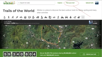
On the web, find the words "Plan your trail" on the homepage, upper right. (See photo below.)
On the app:
  • From Explore: Access the route planner from Explore > View Map > Plan Trail.
  • From your profile: Go to the Planned trails tab and press the Plan Trail button.
Note that you may have to update your app to find this feature. I did. Also note that in the updated app, the spot that used to say "Search by Passing Area" has now been replaced by "Plan Trail" on the "Explore" map. To access the "Search by Passing Area" feature, long press in the desired area.

Plan your trail.webp
 
A selection of Camino Jewellery
Ideal sleeping bag liner whether we want to add a thermal plus to our bag, or if we want to use it alone to sleep in shelters or hostels. Thanks to its mummy shape, it adapts perfectly to our body.

€46,-
I've found Wikiloc tracks for those two but I'm hoping there is a better way for at least one.
When I was experimenting with it this afternoon, I found that it helps if you know what some of the alternatives are, so you can place some reasonable midpoints. If you put in only the two endpoints, you are somewhat at the mercy of the algorithm - whatever it is - that the program uses. I got one result that took me the shortest distance from point A to Point B, but it was over a steep mountain with 1200 m of altitude gain. Adding a midpoint that I knew was on an alternate track I had already found a few days ago by using "search by passing area" gave me a more reasonable alternative. Both my searches were in areas where nothing shows on mapy.cz, but in other areas, mapy might provide some help for good guesses when plotting on Wikiloc. In any case, your previous sleuthing won't have been in vain! Good luck with your project. Sounds like fun.
 
Thank you for this. I've been slowly planning a hybrid camino of four different ones needing two non-camino connections. I've found Wikiloc tracks for those two but I'm hoping there is a better way for at least one. I'll check this feature out.
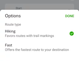
I've been using mapy.cz for these kinds of connections and detours. You can chose between "hiking" and "fast" for your walking options.

Screenshot_20241227_171123_Mapycz.webp
 
Ideal sleeping bag liner whether we want to add a thermal plus to our bag, or if we want to use it alone to sleep in shelters or hostels. Thanks to its mummy shape, it adapts perfectly to our body.

€46,-
Didn't know that. I'll have to try it. Also, I've been experimenting with chatbot. Asking it things like give me a route from SJPP to x with no more than 10K a day of walking etc. It's not perfect, but it does seem to come up with reasonalbe lists as well as places to stay. Obviously, you have to verify it, but it's a new twist.
 
I would love to see the route that you have planned!

I'm slowly planning a hybrid camino to visit some famous (or not so famous) tourist points in Spain. I'm calling it the Camino Ricardo.

The plan so far is to visit these places in order: Ciudad Real, Toledo, Ávila, Segovia, Valladolid?, Wamba?, Toro, Zamora, and Salamanca. Probably spending an extra entire day in each. Zamora and Salamanca may get more time.

The Camino Ricardo is broken down into seven sections with each section usually needing several walking days. The big picture is the following:
Section 1) CAMINO MANCHEGO
Section 2) CAMINO LEVANTE
Section 3) HIGHWAY (N 110)
Section 4) CAMINO MADRID
Section 5) SENDA DEL DUERO (GR14)
Section 6) CAMINO LEVANTE
Section 7) VIA DE LA PLATA (in reverse)​

Currently it looks like 21 walking days for 584 kilometers (365 miles) not counting the Valladolid and Wamba side trips.

I will likely later be placing detailed information about the Ricardo into this forum resource directory:

Who knows, I may be the author of the first itinerary there.
 
Last edited:
€2,-/day will present your project to thousands of visitors each day. All interested in the Camino de Santiago.
I've been using Wikiloc to plan alternative routes for the Camino Portuguese Interior (April 2025) to walk no more than 24km per day or to avoid long steep (10% grade) hills or to pass places to get food. It's been a great tool but because it crowdsources from hikers, the recommended routes often avoid roadways (even for distances of 500m or less) that would make the route significantly shorter. I've had to plot points almost next to one another to get the trail to go where I want it to go. It's possible to "pull" the route where you want it to go but it doesn't always work well. I will often use google maps street view to help me plan the routes in Wikiloc to avoid roadways without shoulders. I plan to download all the trails I've created to access them while we walk. You can see my planned routes if you search for "KGBurk" on Wikiloc. Wikiloc premium is great value for trips to Europe but not nearly as good as Alltrails for North American route planning.
 
I've been using Wikiloc to plan alternative routes for the Camino Portuguese Interior (April 2025)...
That sounds like a great project. Thanks also for sharing your lists, not only of camino routes, but also the GR 92 north of Barcelona. They look very helpful!
Wikiloc premium is great value for trips to Europe but not nearly as good as Alltrails for North American route planning.
Yes, Wikiloc was started in 2006 by two outdoor enthusiasts in Girona, Spain, and has really grown since then. A few days ago I ran across a note in one of my journals that they had over 7 million tracks by 2018, which seemed a lot to me at the time. As of this afternoon, they have 59,410,355 tracks in their database.
 
...and ship it to Santiago for storage. You pick it up once in Santiago. Service offered by Casa Ivar (we use DHL for transportation).
Be aware that Wikiloc is crowdsourced and each and every person’s route is shown so you have to wade through all the routes posted to find the best one for you. Also, unlike Alltrails a recorded Wikiloc trail will have recorded any and all detours off the trail (snacks, drinks, bathroom breaks) unless the recorder paused Wikiloc while making the detour. So there is not one best route on Wikiloc
 

❓How to ask a question

How to post a new question on the Camino Forum.

Most read last week in this forum

Thinking about my next walk. I really want to do the Camino without a mobile phone. Last time I used it quite a lot to find and book accomodation and other things. That was some years ago. What’s...
On a recent thread involving the question whether or not to take a phone on the Camino, some of us got a little off topic talking about the value of having your phone to use translation apps on...
Is there an actual start date yet? The ETIAS website states it is not yet in action.
Happy New Year to us all! For those of us remembering the Camino, and for those of us planning a camino, here's a place to enjoy everyone's photos. This is the 12th 1-a-Day thread since we started...
I have often wondered what it costs the church for each compostela? Thanks for any info David
Loooking forward to everyone's pictures in this new year. Thumbnails of the pictures are always ok. I started with a small local round of 3.3 km. Send us some sun please! Very windy and grey...

Featured threads

❓How to ask a question

How to post a new question on the Camino Forum.

Forum Rules

Forum Rules

Camino Updates on YouTube

Camino Conversations

Most downloaded Resources

Featured threads

This site is run by Ivar at

in Santiago de Compostela.
This site participates in the Amazon Affiliate program, designed to provide a means for Ivar to earn fees by linking to Amazon
Official Camino Passport (Credential) | 2024 Camino Guides
Back
Top