• Remove ads on the forum by becoming a donating member. More here.

Search 74,075 Camino Questions

A 600-Mile Recreational Trail Is Coming to the West’s Sierra Nevada

...and ship it to Santiago for storage. You pick it up once in Santiago. Service offered by Casa Ivar (we use DHL for transportation).
This will be amazing! Close enough for me to drive to and spend a week.

The only concerning thing is this

Joining the region’s world-class mountain biking trails, the celebrated Pacific Crest Trail backpacking route, and epic skiing and outdoor recreation in and around Lake Tahoe, the Lost Sierra Route (a two-foot-wide gravel path) will deliver varied terrain for hiking, cycling, motorcycling, horseback riding, and dog walking suitable for everything from an overnight backpacking adventure to a quick family day trip.

Why would they allow motorcycles on a trail like this?!!
How insane is that!! Two feet wide and gravel???????
 
The 2024 Camino guides will be coming out little by little. Here is a collection of the ones that are out so far.
Thinking about this a little more, and checking out this site, perhaps there will be separate trails for those using human powered transportation and those using motorized vehicles. I hope so!

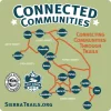
Connected-Communities-Sticker-Greenville-FINAL-OUTLINES-1024x1024.webp
 
I live in one of these communities (Graeagle) and am so excited to see this finally happening! I believe the full trail will connect a variety of surfaces, like the Camino. Some of them will allow for motorized vehicles and others will be strictly walking and biking. Come up and check us out. It’s the most beautiful country and these towns are smaller communities of friendly Mountain folks!
 
I live in one of these communities (Graeagle) and am so excited to see this finally happening! I believe the full trail will connect a variety of surfaces, like the Camino. Some of them will allow for motorized vehicles and others will be strictly walking and biking. Come up and check us out. It’s the most beautiful country and these towns are smaller communities of friendly Mountain folks!
Do you think that it will be possible to walk from town to town?

I haven't spent any time in that area since I was a kid and went to summer camp around there. It is indeed a beautiful area.
 
A great book to listen to while training for the Camino or to relive the experience!
I haven’t researched it closely enough to say for sure. I’m sure you can bike from town to town, but walking might be a stretch.
 
600 miles on gravel dodging bicyclists and motorcycles sounds downright awful! I love that area but there is no way that all those transportation modes can share a two foot wide trail.
 
600 miles on gravel dodging bicyclists and motorcycles sounds downright awful! I love that area but there is no way that all those transportation modes can share a two foot wide trail.
That's what made me think that maybe there will be different trails for different uses.
 
Fail to prepare? reduce your risk by buying this book full of practical info.
2nd ed.
Do you think that it will be possible to walk from town to town?

I haven't spent any time in that area since I was a kid and went to summer camp around there. It is indeed a beautiful area.
The existing Tahoe Rim Trail, while it doesn't exactly go through towns, crosses a few roads where a hiker can get resupplied, and also passes close enough to civilization that you can get off for a shower, pizza and other amenities with a short detour. I'll have to take a closer look at the exact route, but my small forays on the Pacific Crest Trail around Tahoe informs me that motorcycling would be totally impossible at least on that part -- hell, walking on loose, broken granite without poles is an invitation to sprained ankles. I tried one day with a mountain bike and ended up carrying the bicycle most of the time.
 
The existing Tahoe Rim Trail, while it doesn't exactly go through towns, crosses a few roads where a hiker can get resupplied, and also passes close enough to civilization that you can get off for a shower, pizza and other amenities with a short detour.
I have been aware of this 165 mile circular loop trail for quite some time. It sounds like a perfect option for the mountain hikers among us and a person can fly into Reno.
Has anyone on this forum done it and can comment?
 
...and ship it to Santiago for storage. You pick it up once in Santiago. Service offered by Casa Ivar (we use DHL for transportation).
I have walked in the Nevada City / Truckee area in the 1990's and just like the Camino Frances you are going to meet a lot of interesting characters, Bears! Are you prepared for them?
Nope, I unfortunately am not prepared as I have a bear phobia, which has given me pause on many day hikes in the beautiful Rockies over the years. That is one of the many reasons the Caminos have had such an appeal for me.
 
To me this looks like a mountain biking trail disguised as a multiuse trail to get funding. The area already has the Pacific Crest Trail for hiking and horseback riding.
 
To me this looks like a mountain biking trail disguised as a multiuse trail to get funding. The area already has the Pacific Crest Trail for hiking and horseback riding.
My family has deep roots in this area and I still live there part time. The Pacific Crest trail is a thru-hike trail, bypassing the towns and doing very little to help the people here much in terms of publicity or assistance to the economy. There have been a lot of efforts to improve trails up here for both hiking and mountain biking, to attract more visitors. The rising popularity of mountain biking has been very helpful to local economies. I don’t know who thought of this idea of connecting local towns with hiking and biking trails, but it’s brilliant. There are so many cute little towns up here rich in California history. I think this might even be popular with European visitors, who are often very interested in U.S. Western history.
 
...and ship it to Santiago for storage. You pick it up once in Santiago. Service offered by Casa Ivar (we use DHL for transportation).
The one from Galicia (the round) and the one from Castilla & Leon. Individually numbered and made by the same people that make the ones you see on your walk.
Translation please. 😊 I've worked out that JMT is the John Muir Trail, but I'm lost on HST.
High Sierra Trail. It starts in Sequoia National forest and goes east torwards Mt. Whitney, as opposed to the JMT which starts in Yosemite and goes south to whitney. JMT is like 21-23 days for somebody like me, and involves complicated resupply strategies. HST is like 7-9 days, which means no resupply, and it's much easier to get a permit.
 

❓How to ask a question

How to post a new question on the Camino Forum.

Forum Zoom Chats

Join our Camino Forum Zoom chats every Tuesday. See the next one here.

❓How to ask a question

How to post a new question on the Camino Forum.

Forum Rules

Forum Rules

Camino Updates on YouTube

Camino Conversations

Most downloaded Resources

This site is run by Ivar at

in Santiago de Compostela.
This site participates in the Amazon Affiliate program, designed to provide a means for Ivar to earn fees by linking to Amazon
Official Camino Passport (Credential) | 2024 Camino Guides
Back
Top