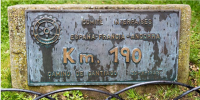
In the Plazade la Alameda, Santo Domingo de la Calzada, there is a fairly small plaque close to the ground. I get my photo taken there every time I pass through SDdlC. On the plaque it says, at the top, COMITE INTERPAISES ESPANA FRANCIA ANDORRA. Below that it says Km 190 and, at the bottom, Camino de Santiago 30 - X - 1999.
SDdlC is 204 km from Saint Jean PdP. Somebody once told me that the plaque is 190 km from Roncesvalles. I accepted that for years, but yesterday I asked Google Maps how far SDdlC is from Roncesvalles: 176 km came the reply. It is 182 km from the French-Spanish border. So I asked the SDdlC tourist office what the 190 km sign meant. Their reply:
VÍA VERDE DEL RÍO OJA- SENDERO DE GRAN RECORRIDO SGR-93
El antiguo trazado ferroviario que unía las localidades de Haro y Ezcaray entre los años 1956 y 1964 fue reconvertido en 1996 por la Fundación de Ferrocarriles Españoles como Vía Verde del río Oja entre las localidades de Santo Domingo de la Calzada y Ezcaray.
Se trata de un sendero balizado de montaña de 190 km que transcurre desde Santo Domingo de la Calzada hasta Valverde, en la parte oriental de la región.
Google Translate: "VÍA VERDE DEL RÍO OJA - LONG-DISTANCE TRAIL SGR-93 The old railway line that linked the towns of Haro and Ezcaray between 1956 and 1964 was converted in 1996 by the Spanish Railways Foundation as the Vía Verde del Río Oja between the towns of Santo Domingo de la Calzada and Ezcaray. This is a 190 km marked mountain trail that runs from Santo Domingo de la Calzada to Valverde, in the eastern part of the region."
GM says that the (shortest) distance from Valverde to SDdlC is 132 km. I googled 'via verde del rio oja' and found that it passes through Casalarreina. When I put this town into the route, the distance became 146 km. Well short of 190 km. However, if the tourist office is right, and the Vía Verde goes from Valverde to SDdlC by some circuitous route that encompasses 190 km, what has the path from SDclC to Ezcaray got to do with it? If you add Haro and Ezcaray into the route, the distance is 162 km. But this would be on a plaque in Ezcaray.
So, according to the SDdlC tourist office, the sign has nothing to do with the Camino de Santiago, despite what is written on it.
Does anyone have an answer to the question in my subject line? No random places on a circle centred on SDdlC with a radius of 190 km, please.


