• ⚠️ Emergency contact in Spain - Dial 112 and AlertCops app. More on this here.
  • Remove ads on the forum by becoming a donating member. More here.

Search 74,075 Camino Questions

Virtual/planning thread: Caminos Girona, Catalán, and Aragonés - Part 2: Montserrat - Santa Cilia

The focus is on reducing the risk of failure through being well prepared. 2nd ed.
I was going to submit this picture to the thread "On the Camino: One Day at a Time, one Photo at a Time 8.0" where a small theme of hills had developed. Then I thought that I should look up and report on the actual elevation values. Then one more thought came to me, the post really belongs here.

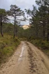
Here is the view I had 4 kms out from Ena on my way to the "new" (c. 1600) and old monasteries of San Juan de la Peña. It is pretty much looking north so the area with the monasteries is hidden by the trees on the right.

IMG_20191104_090917-01.jpeg Screenshot_20220109-121943.png

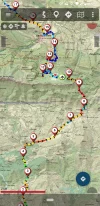
Curiosity grabbed me so I brought up the Ena to Santa Cilia stage of the Camino Catalan on the Mapas de España app and got some approximate numbers. I was at about the "4" spot at 850 m elevation when I took the picture. The monasteries are at about 1,250 m. So I'm looking at a cliff (peña) 400 m (1,300 feet) above me. Things on the way didn't get steep until a short ways past Botaya near kilometer 8 at 900 m. The old monastery is at "12" (the "new" one is near 10.5). So 350 m over 4 km or about a 9% upward slope. Going down to Santa Cruz it's an elevation loss of 450 m over 3 km for a slope of -15%.

Both the routes from SJPdP to Roncesvalles have a 3 km stretch with an average 15% climb.

This webpage (in Spanish) has a couple of aerial photos that show both monasteries in the same picture and some that show the old monastery's setting under the cliff:

http://www.romanicoaragones.com/0-Jacetania/25-SanJuanPena.htm

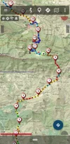
The next pic was deleted but shows up anyway. It is a not as clear picture of the map that is shown better above.
 

Attachments

  • Screenshot_20220109-121943-01.webp
    Screenshot_20220109-121943-01.webp
    106 KB · Views: 13
Last edited:
A selection of Camino Jewellery
Update: I took that PR-C variant listed in post 50 into Cervera today thanks to this post. Wanted to add this to the planning guide—it’s marked as a Camino variant with yellow arrows and the blue signs.

So in Sant Pere dels Arquells, you’ll see a sign that says per N-II that turns right , or straight ahead on the motorcross way. Turn left and up a hill and the arrows start. It added some elevation, but I think I suffered more climbing into Cervera. I recommend this option for the castle ruins.
Personally, I took the tarmac from there, for the sake of my knees -- not much traffic, as most drivers use the motorway.

BTW the waymarkers were very confusing in Cervera in 2019, as not only are there the two options for the Camino, but it's also one of the rare places where the Ignaciano diverges somewhat from from the Camí. Have they made things any less complicated ?
 

❓How to ask a question

How to post a new question on the Camino Forum.

Featured threads

❓How to ask a question

How to post a new question on the Camino Forum.

Featured threads

Forum Rules

Forum Rules

Camino Updates on YouTube

Camino Conversations

Most downloaded Resources

This site is run by Ivar at

in Santiago de Compostela.
This site participates in the Amazon Affiliate program, designed to provide a means for Ivar to earn fees by linking to Amazon
Official Camino Passport (Credential) | 2024 Camino Guides
Back
Top