Search 74,075 Camino Questions

190 kilometres from where?

Bert45

Veteran Member
Time of past OR future Camino
2003, 2014, 2016, 2016, 2018, 2019
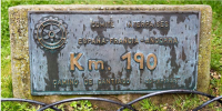
In the Plazade la Alameda, Santo Domingo de la Calzada, there is a fairly small plaque close to the ground. I get my photo taken there every time I pass through SDdlC. On the plaque it says, at the top, COMITE INTERPAISES ESPANA FRANCIA ANDORRA. Below that it says Km 190 and, at the bottom, Camino de Santiago 30 - X - 1999.
SDdlC is 204 km from Saint Jean PdP. Somebody once told me that the plaque is 190 km from Roncesvalles. I accepted that for years, but yesterday I asked Google Maps how far SDdlC is from Roncesvalles: 176 km came the reply. It is 182 km from the French-Spanish border. So I asked the SDdlC tourist office what the 190 km sign meant. Their reply:
VÍA VERDE DEL RÍO OJA- SENDERO DE GRAN RECORRIDO SGR-93
El antiguo trazado ferroviario que unía las localidades de Haro y Ezcaray entre los años 1956 y 1964 fue reconvertido en 1996 por la Fundación de Ferrocarriles Españoles como Vía Verde del río Oja entre las localidades de Santo Domingo de la Calzada y Ezcaray.
Se trata de un sendero balizado de montaña de 190 km que transcurre desde Santo Domingo de la Calzada hasta Valverde, en la parte oriental de la región.
Google Translate: "VÍA VERDE DEL RÍO OJA - LONG-DISTANCE TRAIL SGR-93 The old railway line that linked the towns of Haro and Ezcaray between 1956 and 1964 was converted in 1996 by the Spanish Railways Foundation as the Vía Verde del Río Oja between the towns of Santo Domingo de la Calzada and Ezcaray. This is a 190 km marked mountain trail that runs from Santo Domingo de la Calzada to Valverde, in the eastern part of the region."
GM says that the (shortest) distance from Valverde to SDdlC is 132 km. I googled 'via verde del rio oja' and found that it passes through Casalarreina. When I put this town into the route, the distance became 146 km. Well short of 190 km. However, if the tourist office is right, and the Vía Verde goes from Valverde to SDdlC by some circuitous route that encompasses 190 km, what has the path from SDclC to Ezcaray got to do with it? If you add Haro and Ezcaray into the route, the distance is 162 km. But this would be on a plaque in Ezcaray.

So, according to the SDdlC tourist office, the sign has nothing to do with the Camino de Santiago, despite what is written on it.
Does anyone have an answer to the question in my subject line? No random places on a circle centred on SDdlC with a radius of 190 km, please.
 
Join the Camino cleanup. Logroño to Burgos May 2025 & Astorga to OCebreiro in June
Interesting puzzle.

Is this link relevant?

Also, in OsmAnd with Configure Map set to enable trails, GR 93 does appear. It goes in a circuitous manner from Valverde to SDdlC. I did not measure its route length.
 
Last edited:
Could it be, that the 190km denotes exactly what the tourist office says, but the numbers are simply way out.. like about half the mojóns and signs on all of the caminos all over Spain?
 
Join the Camino cleanup. Logroño to Burgos May 2025 & Astorga to OCebreiro in June
Interesting puzzle.

Is this link relevant?

Also, in OsmAnd with Configure Map set to enable trails, GR 93 does appear. It goes in a circuitous manner from Valverde to SDdlC. I did not measure its route length.
I could not find a reference to Valverde or Santo Domingo on that link, but it led me to this site: https://www.komoot.com/collection/1696544/mountains-valleys-and-trails-in-la-rioja-gr-93-by-e-bike where the writer says: "This long-distance trail crosses the valleys and sierras of southern La Rioja along paths and tracks for 189 kilometres (117 mi). It links 26 villages and some uninhabited settlements ... " The route is completely different from the one that Google Maps would take from SDdlC to Valverde, but it does seem to go to Ezcaray, though, as no names are given on the maps, apart from SDdlC and towns not on the path, I can't confirm it.
189 km is near enough. It only leaves the question: Why does it say Camino de Santiago on the sign?
 
I asked Google Maps how far SDdlC is from Roncesvalles: 176 km came the reply.
You are correct with 176 by walking (google takes the fastest route) but 213 if you direct google to take the camino route (since June 2024) - it is the CAR that comes in at 193 so that is obviously what is displayed
 
COMITE INTERPAISES ESPANA FRANCIA ANDORRA
Km 190
Camino de Santiago 30 - X - 1999​
None of the explanations for this text on a plaque in Santo Domingo de la Calzada make sense. If the purpose of the plaque is to inform about the distance between two towns, why not name the two towns, or at least the distant town. If its purpose is to inform about a GR or commemorate its creation why not name the GR.
 
The 2024 Camino guides will be coming out little by little. Here is a collection of the ones that are out so far.
Has anybody actually any doubts that this plaque commemorates some event or other that involves an Inter-Country Committee Spain-France-Andorra and what they did in connection with the Camino de Santiago aka Camino Francés in the autumn of the Holy Year 1999?

Whatever Google Maps or Apple Maps or Via Michelin say about how long some distance between two points in 2024 is and what it may have been in 1999 for walkers or cyclists or motorcyclists or motorists with a car, they were presumably not in the business of providing accurate data based on satellite measurements for the public of a course that is not defined in minute details. 190 km was a good enough number for them.
 
The plaque looks like shown below. The photo shows context that is missing in the first post: the logo of Rotary International! Context is useful and helps with understanding stuff … The plaque faces the “Casa de la Cofradria del Santo“ which houses a Camino pilgrim albergue.

1726995847444.png
 
Last edited:
You are correct with 176 by walking (google takes the fastest route) but 213 if you direct google to take the camino route (since June 2024) - it is the CAR that comes in at 193 so that is obviously what is displayed
That's interesting, Camo. The route by car takes a big diversion from the Camino route. How do you get google to take the camino route? I mean, is there an easier way than by putting the name of every village between Roncesvalles and SDdlC?
 
Ideal sleeping bag liner whether we want to add a thermal plus to our bag, or if we want to use it alone to sleep in shelters or hostels. Thanks to its mummy shape, it adapts perfectly to our body.

€46,-
The plaque looks like shown below. The photo shows context that is missing in the first post: the logo of Rotary International! Context is useful and helps with understanding stuff … The plaque faces the “Casa de la Cofradria del Santo“ which houses a Camino pilgrim albergue.

View attachment 177905
And just in case this needs mentioning: The Rotary Club has numerous Intercountry Committees, who are fostering goodwill and peace among nations. Among them is the ICC Spain-France-Andorra and it is they who had this plaque installed on the Camino de Santiago in Santo Domingo de la Calzada in 1999.
 
How do you get google to take the camino route?
Depends on what you are after eg to get turn by turn directions or creating a "smoothed" track in Google Earth for whatever reason but generally you would deal with multiple shorter sections of a day walk or less
 
Transport luggage-passengers.
From airports to SJPP
Luggage from SJPP to Roncevalles
It’s now established as a fact that the answer from the tourist office in Santo Domingo de la Calzada is nonsense as an explanation for the text on the plaque in question.

I think I said it before to the OP: One has to live with uncertainties and inaccuracies in the real world. ☺️

Of course Santo Domingo de la Calzada is punto kilometrico 190 - kilometre point 190 - on the Spanish Camino de Santiago.

If you have nothing better to do then do what I did: Add up the kilometres from Roncesvalles to Santo Domingo as listed on Brierley’s maps and as reported in forum member @HBS60 ’s very recent threads. I think that Brierley measured on the ground while @HBS60 relied on an app that is presumably google based … 😀
 
Train for your next Camino on California's Santa Catalina Island March 16-19
do what I did
And your answers were ???

For me Brierley says 191.8 but that was from ed 1 20 years ago so is probably what was used here

Hector recorded all his side trips for eat/sleep and got lost many times so not even worth adding it up IMHO, BUT he did confirm that the trails I am using (from this forum) is the exact same trail he took so his Relive tracks were a real Godsend
 
Last edited:
I added the distances on gronze.com from Roncesvalles to SDdlC. I got 185.9 km. I hope someone will check that. That's not far out. It's good to know that the distance has got less over the years :).
If you go to Santo Domingo, don't ask for information at the tourist office. It will probably be rubbish.
 
The year 1999 when the Rotary plaque was installed was a time when Camino pilgrims were not wearing smartphones and other electronic devices with GPS capability and a time without apps capable of registering distances walked by their owners; a time when the Pilgrim Office in Santiago did not yet issue Distance Certificates; a time before somebody with decision power in Galicia decided to have km waymarkers installed that would indicate distances with a precision - :rolleyes: :rolleyes: :rolleyes: - of three digits - :rolleyes: :rolleyes: :rolleyes: - after the decimal comma aka decimal point. In short, when Camino pilgrims were less obsessed with - or fascinated by, if you like - kilometres and metres walked by them and exactly where they had walked them or were going to walk them.

And that small plaque on the grass that commemorates something we don't know about will not be modified or replaced just because numbers peeled from Brierley or Gronze or WisePilgrim or Google Maps or Apple Maps or dozens if not hundreds of similar sources don't add up to exactly 190 km.

The Camino de Santiago is not a singular narrow footpath trail marked by yellow paint; it is a whole corridor from the Pyrenees to the town of Santiago chock-a-block full of patrimony and traces of history from the Middle Ages. It's a concept, it's an idea. Even the modern A-12 motorway has signposts saying "Camino de Santiago".

If anyone is on a quest to find a source with distances that add up to 190 km ending in Santo Domingo de la Calzada, I'd recommend starting by having a look at Elias Valiña's guidebook (first edition of 1985 or a later edition up to 1999) or at road maps of Navarra and Rioja that don't show all the streets and roads and paths that have been modified or newly created and built during the last 25-30 years. You might get lucky ... 😶
 
Last edited:
Train for your next Camino on California's Santa Catalina Island March 16-19
And that small plaque on the grass that commemorates something we don't know about will not be modified or replaced just because numbers peeled from Brierley or Gronze or WisePilgrim or Google Maps or Apple Maps or dozens if not hundreds of similar sources don't add up to exactly 190 km.
Exactly, and neither will the official waymarkers (to 3 decimal places) be all changed every time another expressway causes a change of say +/- 1.325 km in the distance.

But for me the bottom line is that each pilgrim has their OWN distance as even if they stick exactly to these waymarkers they need to eat/sleep at humpteen places off the main drag.
 

❓How to ask a question

How to post a new question on the Camino Forum.

Most read last week in this forum

Ok so ... this past spring (2024) I decided to walk the "lower" route into Pamplona and became really lost. I just keep thinking about it and it really bugs me. Where did I go astray? At the...
Hi all, doing the Camino Francés was one of my childhood dreams. I grew up hearing epic stories about it, and wanted to be a part of it. Like everyone, however, I have my quirks, and wanted to...
I asked the tourist office for information about the statue of the pilgrim at the entrance to Carrión de los Condes. Here is their reply. auto-translated: "The Monument to the Pilgrims" is a...
Hi everyone. I am in Roncevalles alburgue right now in November 2024. I was quoted 100 euro for luggage transport from Buricot. They said it's slow season and they don't have any other luggage...
I understand that footwear on the Camino is a personal choice. I will start my first Camino on the Camino Frances in the first part of April. With the varying weather conditions, what...
I’ve emailed both albergues a while back inquiring about booking for mid-April 2025. They both indicated that they’d take reservations in Nov/Dec. Outside of checking every day, do folks have a...

Featured threads

❓How to ask a question

How to post a new question on the Camino Forum.

Featured threads

Forum Rules

Forum Rules

Camino Updates on YouTube

Camino Conversations

Most downloaded Resources

This site is run by Ivar at

in Santiago de Compostela.
This site participates in the Amazon Affiliate program, designed to provide a means for Ivar to earn fees by linking to Amazon
Official Camino Passport (Credential) | 2024 Camino Guides
Back
Back
Top