• ⚠️ Emergency contact in Spain - Dial 112 and AlertCops app. More on this here.
  • Remove ads on the forum by becoming a donating member. More here.

Search 74,075 Camino Questions

Ruta/Camino del Besaya (ES30a) = Calzada romana = Calzada de los Blendios (GR73)?

peterott

Member
Time of past OR future Camino
2025
Hello,

just some sort of stupid question: I found a very nice Spanish book from 2002 (ok, pretty old one) which describes - according to my limited Spanish language knowledge - the development of a hiking route La Calzada de los Blendios in the late 90es from Herrera De Pisuerga to Suances and then describes the trail in 7 legs
The book: https://www.cervantes.com/libro/9788495742124/calzada-de-los-blendios-la/
web description: https://www.desnivel.com/excursionismo/calzada-de-los-blendios-gr-73/

Now I am reading that the Ruta/Camino del Besaya is from Santander to Carrión de los Condes, means a further 46km away from Herrera de Pisguera and the beginning in Suances is even avoided. Checking a couple of webpages on the net it seems that the Ruta del Besaya just adds the last two legs down to Carrión de los Condes in order to reach the Camino Frances - and instead of going a swing from Santander to Suances, the Camino rather says "go directly from Santander via Torrelavega to Los Corrales de la Buelna" to connect the Camino del norte to the Ruta Besaya by skipping the piece from Suances to Los Corrales de la Buelna of the "Calzada de los Blendios".
(Example of the Ruta Besaya description here: https://vivecamino.com/ruta-del-besaya-camino-de-santiago-historico-no-771/)

Means that the routes are basically the same, but both endpoints differ quite a bit. Am I right or wrong?
 
Ideal sleeping bag liner whether we want to add a thermal plus to our bag, or if we want to use it alone to sleep in shelters or hostels. Thanks to its mummy shape, it adapts perfectly to our body.

€46,-
Bonus point - which confuses me most:

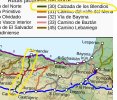
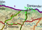
This is a part of the Caminos map that lots of people have probably seen on wiki-web.
There, the "Ruta del Besaya" from Santander to Carrión de los Condes is shown but noted as (30) Calzada de los Blendios - that should go from Suances to Herrera de Pisuerga (both start/endpoints a good portion away from the shown Camino-connection points Condes and Santander).

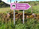
That's probably the origin of my confusion between GR73 and ES30a and I wonder if there are multiple walking signs, or only the camino-shell is used as for the main part of the trail from Herrera at least until Los Corrales de Buelna, where the two routes equal each other.


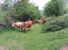
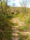
calzada_de_los_blendios.jpg
 
Hola Peter . Caminé buena parte de la Ruta del Besaya - Calzada de los Blendios en verano de 2020. Un camino magnífico, solo apto con buen tiempo (entre mayo y octubre-noviembre). Comienza en Suances (antiguo puerto romano), pasa cerca de Torrelavega, y continúa por Corrales de Buelna, Bárcena Pie de Concha, Santiurde de Reinosa, Reinosa, Aguilar de Campóo, Alar del Rey, Herrera de Pisuerga y finaliza en Carrión de los Condes (Palencia), donde enlaza con el Camino Francés. Hay señales de GR y algunas flechas amarillas. Es un camino histórico, de época romana o anterior, hoy totalmente solitario (no lo deben hacer ni 20 peregrinos al año) y que se cruza en varios puntos con otras rutas (Camino del Norte, Camino Olvidado, Camino Lebaniego Castellano, Camino Francés. ..).

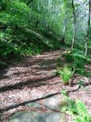
Hay etapas duras pues cruza la cordillera Cantábrica. Magníficos los diferentes tramos por calzadas romanas (tal vez mejor denominarlas "calzadas medievales construidas sobre antiguas calzadas romanas"). Historia y arte para llenar libros. Iglesias romanticas increibles. Disfrutarás, te lo aseguro.


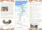
folleto calzada blendios 1.jpg
 
Fail to prepare? reduce your risk by buying this book full of practical info.
2nd ed.
Las etapas del camino serían las siguientes (según la versión "oficial"):

1-Suances-Santilla del Mar (7Km).
2-Santillana del Mar-Los Corrales de Buelna (18Km).
3-Los Corrales de Buelna-Bárcena de Pie de Concha (23Km).
4-Bárcena de Pie de Concha- Reinosa (21Km).
5-Reinosa-Aguilar de Campoo (28Km).
6-Aguilar de Campoo-Santa María de Mave (10Km).
7-Santa María de Mave-Herrera de Pisuerga (20Km).
8-Herrera de Pisuerga- Bárcena de Campos (19Km).
9-Bárcena de Campos-Carrión de los Condes (20Km).


Por supuesto, NADIE suele hacer una etapa de 7km o de 10km 🤣🤣🤣🤣. Por tanto, se puede realizar en 7 u 8 días.

Te recomiendo NO PASAR por Santillana del Mar (si ya conoces dicha localidad, cruce con el Camino del Norte) y seguir el paseo peatonal y de ciclistas que une Suances y Los Corrales de Buelna, junto al río Besaya (con su cauce siempre a nuestra izquierda). Es mucho más corto junto al río, y te evitas los turistas y las aglomeraciones de Santillana. Además, la señalización por Santillana es casi inexistente. Durante el resto del camino, al menos en la parte cántabra, no me perdí (hay que ir siempre atento, mejor llevar el track en el móvil o en un GPS).

También te sugiero dormir en Santiurde de Reinosa, donde hay un albergue privado magnífico (allí te informarán muy bien de las siguientes etapas. Cuando fui (2020) había albergues (no exclusivos de peregrinos) en Pie de Concha, en Santiurde de Reinosa, en Herrera de Pisuerga y, por supuesto, en Carrión de los Condes.

Lo que dices que comienza en SANTANDER es incorrecto. Comienza en Suances. Puedes ir de Santander a Suances en autobús, o bien vía Torrelavega.

El final es en Carrión de los Condes. En Herrera de Pisuerga había una importante guarnición romana, sería el "punto final" como calzada romana. Pero si lo quieres hacer como Camino de Santiago (que lo fue y lo es, aunque muy muy muy minoritario), lo lógico es seguir hasta Carrión. Un saludo y buen camino.
 
Last edited:
Muy bien, Carles, gracias. Very nice pictures!!!!!

Ok, I kinda thought that there will be "double markings" with the yellow Camino shell and your mentioned GR73 markings :)

I will walk the opposite way. I come from the Camino Olvidado and enter the GR73/ES30a at Aguilar de Campoo and will walk towards my end destination Santander or with the swing towards Suances and then Santander, depending if I have two more days left.

Planned trip in Mid-April/Early-May for roughly 3 weeks:
54km on the Camino del Norte until San Vicente de la Barquera
71km on the Camino Lebaniego till the Monasterio de Santo Toribio
102km continuing on the Ruta Vadiniense to Cistierna
104km on the Camino Olvidado to Aguilar de Campoo
100km on the Camino Besaya/Calzada de los Blendios till Suances then Santander, or directly to Santander, depending on the date of the flight back home.

roundtrip.JPG
 
Last edited:
The one from Galicia (the round) and the one from Castilla & Leon. Individually numbered and made by the same people that make the ones you see on your walk.
Muy bien, Carles, gracias. Very nice pictures!!!!!

Ok, I kinda thought that there will be "double markings" with the yellow Camino shell and your mentioned GR73 markings :)

I will walk the opposite way. I come from the Camino Olvidado and enter the GR73/ES30a at Aguilar de Campoo and will walk towards my end destination Santander or with the swing towards Suances and then Santander, depending if I have two more days left.

Planned trip in Mid-April/Early-May for roughly 3 weeks:
54km on the Camino del Norte until San Vicente de la Barquera
71km on the Camino Lebaniego till the Monasterio de Santo Toribio
102km continuing on the Ruta Vadiniense to Cistierna
104km on the Camino Olvidado to Aguilar de Campoo
100km on the Camino Besaya/Calzada de los Blendios till Suances then Santander, or directly to Santander, depending on the date of the flight back home.

View attachment 176165
Has diseñado una magnífica ruta, Peter. Has seleccionado tramos de lo más bonito de varios caminos. Disfrutarás. A finales de abril estará precioso, tal vez un poco fresco, pero el mayo suele mejorar. Yo hice el Lebaniego-Vadiniense hace años, en un mes de abril, y encontré nieve en Fuente Dé y en la subida a Pandetrave. Te recomiendo que utilices la guía-web de Gronze.com en el Norte, en Lebaniego y en Vadiniense (sobretodo los apartados "Al Loro" y "Recorrido") y la app Gronze Maps (es gratuita y muy práctica). Buen camino, ya nos explicarás
 
Found a further name-variant in internet-literature for the Ruta/Camino del Besaya (ES30a)/Calzada romana/Calzada de los Blendios (GR73) path:

"Ruta de Campoo" from Santander to Carrión de los Condes
 

❓How to ask a question

How to post a new question on the Camino Forum.

Featured threads

❓How to ask a question

How to post a new question on the Camino Forum.

Forum Rules

Forum Rules

Camino Updates on YouTube

Camino Conversations

Most downloaded Resources

Featured threads

This site is run by Ivar at

in Santiago de Compostela.
This site participates in the Amazon Affiliate program, designed to provide a means for Ivar to earn fees by linking to Amazon
Official Camino Passport (Credential) | 2024 Camino Guides
Back
Top