Search 74,075 Camino Questions

Two pilgrims lost and found in SJPP-Roncesvalles

Just goes to show that reliance on a GPS rather than the brain and eyes God gave us can lead to a bad outcome. These machines cannot think, so it helps to have map-reading ability and outdoor skills in addition to these admittedly powerful electronic tools, so that a manual override is possible.
(The article that @Albertagirl turned us onto shows the danger of turning off our cognitive function when using GPS. It's conclusion bears repeating here;
"Take yourself off autopilot. Become aware of your environment. Make a habit of skepticism, including skepticism toward your own assumptions and gut feelings.")
Believe it or not... walking into Virgen Del Camino on a perfectly good footpath we watched in horror as a young pilgrim following her phone directions crossed a barrier onto the main road.

We frantically signalled her back over and discovered that she had her map app set to drive and not walk. Helped her with the setting and she was on her Way again.

Her response to being asked why she walked out onto a busy highway was my map GPS told me to!
 
Fail to prepare? reduce your risk by buying this book full of practical info.
2nd ed.
3rd Edition. Vital content training & pack guides avoid common mistakes, bed bugs etc
I am saddened to read such unkind and disparaging remarks on this thread. I imagine if the lost pilgrims read this page, they may feel even worse. And if future pilgrims read this commentary, they may think this a most judgmental group and be scared of making a mistake or taking a risk, lest provoking the negative judgments of others. Please, be kind - what do the sacred lessons of the Camino amount to, if we are do not practice decency, kindness and compassion with our fellow travelers on the path?
 
I am saddened to read such unkind and disparaging remarks on this thread. I imagine if the lost pilgrims read this page, they may feel even worse. And if future pilgrims read this commentary, they may think this a most judgmental group and be scared of making a mistake or taking a risk, lest provoking the negative judgments of others. Please, be kind - what do the sacred lessons of the Camino amount to, if we are do not practice decency, kindness and compassion with our fellow travelers on the path?
Mmm... Yes I hear what you say, but...no! I don't think I am being unkind by thinking they were stupid by starting off at 4pm. for what was (is) by all standards a reasonably demanding walk. In mountains. And totally unprepared.
Sorry if I offend but ...
Being kind is often telling the truth, as hard as it is to hear.
 
Transport luggage-passengers.
From airports to SJPP
Luggage from SJPP to Roncevalles
Train for your next Camino on California's Santa Catalina Island March 30 to April 2
Ok, point taken.
I'll have to walk (at least) one more camino to make up for my sins....
Thank you for your good nature on this. After posting I went to the kitchen and on the way realized that I may have been too blunt and unkind myself. Another stupid mistake.

As for the lost pilgrims: they over-estimated their abilities and may have gotten lost in the dark. The next day they may have realized that they could call for help but then have to pay a huge search and rescue bill. So maybe they tried to extricate themselves to avoid the cost until they got too hungry or thought that the phone might die.
 
I have been thinking as I was walking this morning how grateful I am at having come across this forum before going on my first camino last fall. I knew nothing about the camino(s) before then but just that I felt called to walk something or other in Spain called the camino de Santiago. I took about a year to prepare, and lurked on this website for four or five months before signing up and starting to ask questions. I am one of those people might generally be regarded on the forum as over-preparing. What additional stupid or ignorant (in the literal sense) things might I have done without all of you to help me in my preparations? Thanks very much to all of you. Who knows? You might have saved my life.
 
Fail to prepare? reduce your risk by buying this book full of practical info.
2nd ed.
Having read about this poor unfortunate couples 4 day adventure I started to have 2nd thoughts about hubby and my abilities to navigate on our rapidly approaching 1st full Camino Frances ( we begin in St.J.P.deP. 20th Sept ) . "Are we mad ? Why are we doing this ? If it can happen to them it could happen to us ! Etc , etc etc ." But while working the night shift in my local nursing home I noticed on the wall a simple poem which had been framed and mounted for Positive Aging Week 2012 but I had not paused to read it until recently ! I thought it embodied some of the reasons why we return again and again to walk a Camino :

Along Life's Road .
-----------------------

Along the path that lies ahead , what shall I find there ?
Shall I find a quiet spot to meditate in prayer ?

A shady bower , a peaceful nook , tall trees along the way ,
a place to read a favourite book , where summer breezes play ?

Shall I achieve my hopes and dreams in all that's good and true ,
And find , meandering, a stream that winds to pastures new ?

What do we seek along Life's road , what do we hope to find ?
Perhaps the greatest gift of all , Contentment , peace of mind .

By Dorothy M. Loughran .
 
Last edited:
OK - mea culpa!
Maybe what is needed is some practical advice/notices at the Pilgrim Office in St Jean (please bear with me - I have not been to St Jean (next May) so this maybe a surperfluous post) stating how long it will take to walk to: Orrison; Valcarlos; Roncesvalles and maybe even the weather forecast for the day to next day. Also include advice on what to do IF you get lost.
I am aware of the notice by the Navarra Provincial Govt about search fees (if you get lost during the winter on Napoleon Trail) but surely if you get lost during the summer your life should not depend upon being able to pay a E5000 fine/fee. (Please be kind when you reply!!) :);):(:D:rolleyes:
 
€2,-/day will present your project to thousands of visitors each day. All interested in the Camino de Santiago.
I am aware of the notice by the Navarra Provincial Govt about search fees (if you get lost during the winter on Napoleon Trail) but surely if you get lost during the summer your life should not depend upon being able to pay a E5000 fine/fee. (Please be kind when you reply!!)
As far as I can see it, the general rule for charging for the rescue is a behavior showing blatant negligence or recklessness. The application seems to be casuistic and quite subjective. Some examples given are not following signposts or official warnings, lack of proper equipment, unnecesary call for help. The topic has been widely discussed in Spain, and each autonomous government (as Navarra, León, etc.) seems to apply its own criteria.
 
Last edited:
... Maybe what is needed is some practical advice/notices at the Pilgrim Office in St Jean (please bear with me - I have not been to St Jean (next May) so this maybe a surperfluous post) stating how long it will take to walk to: Orrison; Valcarlos; Roncesvalles and maybe even the weather forecast for the day to next day. Also include advice on what to do IF you get lost. ...

That is exactly what the pilgrims office in SJPdP does plus a lot of other things ;-) Buen Camino, SY
 
The one from Galicia (the round) and the one from Castilla & Leon. Individually numbered and made by the same people that make the ones you see on your walk.
I am saddened to read such unkind and disparaging remarks on this thread. I imagine if the lost pilgrims read this page, they may feel even worse. And if future pilgrims read this commentary, they may think this a most judgmental group and be scared of making a mistake or taking a risk, lest provoking the negative judgments of others. Please, be kind - what do the sacred lessons of the Camino amount to, if we are do not practice decency, kindness and compassion with our fellow travelers on the path?
The moderators seem to be giving us kiddies a fair bit of space to see how we work our Way out of this one ;)

(Thank you!)

It's so easy to be judgemental, almost natural to the human condition :rolleyes: but I think that a lot of the posts have shown just how easy it is to get into a spot - or more - of bother. We'd all love to know exactly what happened and why. Curiosity being another aspect of the human condition.

I would like to believe that if the unfortunate adventurous couple came across this thread (and they may well be lurkers or members of this Forum), that they would feel confident enough to post an account of their Camino experience and that we, as a community, would welcome them, learn a lot from their adventures, have a laugh together and respond with how can we help? should they want to complete their journey.
 
Maybe what is needed is some practical advice/notices (...)stating how long it will take to walk to: Orrison; Valcarlos; Roncesvalles and maybe even the weather forecast for the day to next day.
If I remember rightly, the distances between each stretch - and how long it is going to take to walk them - are also posted above the bar at Orrisson :)
 
There was a sun in the sky ... very hard to not find your way if you get lost .. but it has given us great fun and I am glad that they are safe ... though, not quite certain what 'safe' really means to these two Brits. :)
Yes by pointing the hour hand of your watch at the sun (if visible) and bisecting the angle between that and 12 on your watch you find South.... ( I'm living in Guildford Surrey where this couple came from.... and over 50 too....I wonder if I know them...)
 
A selection of Camino Jewellery
Yes by pointing the hour hand of your watch at the sun (if visible) and bisecting the angle between that and 12 on your watch you find South.... ( I'm living in Guildford Surrey where this couple came from.... and over 50 too....I wonder if I know them...)

@Bonita Holland
Just the words "bisecting the angle" make me feel giddy. I cannot do anything resembling geometry. This past June I finally quit taking a compass on my wilderness hikes, admitting to myself that my inability to consistently remember whether I should add or subtract the 29 degrees of declination would almost certainly get me walking 58 degrees off from where I should be going.
And noting that @BonitaHolland's method works in the northern hemisphere and where the solar time and social time are closely aligned, should one one an adjustment and bisect the angle between the hour before current time to account for the fact Spain (and Portugal) are so much further west. After all, one wants this to be accurate, surely!
 
Last edited:
The one from Galicia (the round) and the one from Castilla & Leon. Individually numbered and made by the same people that make the ones you see on your walk.
And noting that @BonitaHolland's method works in the northern hemisphere and where the solar time and social time are closely aligned, should one one an adjustment and bisect the angle between the hour before current time to account for the fact Spain (and Portugal) are so much further west. After all, one wants this to be accurate, surely!
@dougfitz
I couldn't make any sense out of your post, either, and was most relieved, when I looked at my watch to see that it just has a lot of numbers on it and no hands.
 
Did any of you ever actually use the analogue wrist watch method or the stick in the ground and its shadow method to find out where to go? I never did. And I don't trust the moss method. Moss seems to grow east, south, north and west.

Yes, I used the watch method many times, the stick in the ground method never and the moss method also never. Buen Camino, SY
 
The one from Galicia (the round) and the one from Castilla & Leon. Individually numbered and made by the same people that make the ones you see on your walk.
I hope you still have meat left on those finger tips:)
People are human they make wrong decisions. Getting lost is a universal world wide issue. I have found lost hunters, hikers. Most have been very intelligent people. They panic & will start running, get hot, discard Clothing & use up all of their energy. If they are still alive when you find them they are a mess emotionally. If you are human you share a tear. If you have to carry a body out you share a tear with the family.
This couple did exactly what you should do shelter the best way you can in place.
 
Did any of you ever actually use the analogue wrist watch method or the stick in the ground and its shadow method to find out where to go? I never did. And I don't trust the moss method. Moss seems to grow east, south, north and west.

The analogue watch method works whenever the sun is visible in the Northern hemisphere and in reflex in the Southern Hemisphere (though for precision an adjustment should be made for any seasonal variances in local standard time). The 'stick in the ground' method takes time, because you need to know what time it is or wait for a full day to establish solar zenith. The moss method only works in open country where in the Northern Hemisphere moss tends to aggregate on the northern face of an isolated tree (contrariwise in the Southern). This will only apply in open country - in a forest moss grows where-ever it feels like.

Navigators might also gain comfort from an awareness of prevailing winds and their impact on exposed tree shapes; the direction of flow of rivers from watersheds; the identification of Polaris or the Southern Cross and the effect planetary rotation on Orion's belt.

Pilgrims are advised to follow the yellow arrows, and if you can't find one, to walk back to the last one you did.
 
Get a spanish phone number with Airalo. eSim, so no physical SIM card. Easy to use app to add more funds if needed.
@Tincatinker & SY
You constantly entertain me, the discussion of rotation to lichen. :)
My world view is if I eat lichen my stomach could begin to rotate. I carry a compass myself. That way I will always walk in somewhat of a straight line & always follow streams down. People always locate close to water. I did however get lost in London coming out of the tube after dark. Just happened to be carrying my compass.
 
This past June I finally quit taking a compass on my wilderness hikes, admitting to myself that my inability to consistently remember whether I should add or subtract the 29 degrees of declination would almost certainly get me walking 58 degrees off from where I should be going.

Albertagirl and moderators, I thought of sending this as a private message but it may be of interest to others. I'll not post anymore in this thread on compasses. PM me if you think it will be helpful. But I don't want Albertagirl getting lost in the wilderness because she doesn't take a compass.

A compass with declination adjustment takes care of the problem of adding or subtracting the declination. With a small screwdriver attached to the compass lanyard you adjust a screw at the bezel at the start of your hike. This mechanically changes the direction of the arrow outline that the magnetic needle has to line up with. So if you want to go north you lineup the pointer to 360 degrees and then move the compass until the needle is within the outline. The outline now points to magnetic north but the direction of travel arrow points true north. With the declination adjustment it is as easy to do map to ground as ground to map.

I used a Silva Ranger model compass decades ago in a US Forest Service job. It had the declination adjustment feature and, although handheld, was used to survey property lines with an accuracy of 1 in 40 (walk a half mile and be in sight of the corner marker nailed to a tree; the property line got adjusted later). I picked up a Ranger for my own use later. Newer models of the Ranger are lighter (plastic bezels) and have map scales, rulers and map magnifiers on the base. Add some reflective tape to the outside of the cover.

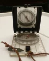
The attached photo shows my compass. You may be able to see the adjustment screw at the NE mark on the bezel (it is elsewhere now.) With the adjustment screw I've set the black outline arrow for a declination of 29 degrees where true north is west of magnetic north (like in Alberta. [Edit: I'm just taking your word for this.]) I've set the bezel to 360 degrees because I want to travel northwards to the geographical pole, not the magnetic pole. The mirror is set at about a 45 degree angle to reflect the compass and base. The mirror helps with accuracy. You sight through the notch when the line on the mirror lines up with markings on the compass base (I'm a little off in the photo, although the line goes through the little yellow arrow where the bezel says "N" the line should also be going though the yellow marker to the top of the reversed "S".)

Anything more about this on the forum would be too off topic. Check with someone from an orienteering club, scouting group, park or forest service ranger or, if you get lucky, a knowledgeable sales clerk. There are videos on Youtube too of course but I didn't have time to sit through them to ensure that they showed how to use declination adjustment in addition to the older kinds.

Google search with something like: Silva Ranger CL declination adjustment

Also, compasses used in the northern hemisphere don't work well in the southern hemisphere and vice versa.
compass.webp
 
Last edited:
Albertagirl and moderators, I thought of sending this as a private message but it may be of interest to others. I'll not post anymore in this thread on compasses. PM me if you think it will be helpful. But I don't want Albertagirl getting lost in the wilderness because she doesn't take a compass.

A compass with declination adjustment takes care of the problem of adding or subtracting the declination. With a small screwdriver attached to the compass lanyard you adjust a screw at the bezel at the start of your hike. This mechanically changes the direction of the arrow outline that the magnetic needle has to line up with. So if you want to go north you lineup the pointer to 360 degrees and then move the compass until the needle is within the outline. The outline now points to magnetic north but the direction of travel arrow points true north. With the declination adjustment it is as easy to do map to ground as ground to map.

I used a Silva Ranger model compass decades ago in a US Forest Service job. It had the declination adjustment feature and, although handheld, was used to survey property lines with an accuracy of 1 in 40 (walk a half mile and be in sight of the corner marker nailed to a tree; the property line got adjusted later). I picked up a Ranger for my own use later. Newer models of the Ranger are lighter (plastic bezels) and have map scales, rulers and map magnifiers on the base. Add some reflective tape to the outside of the cover.

The attached photo shows my compass. You may be able to see the adjustment screw at the NE mark on the bezel (it is elsewhere now.) With the adjustment screw I've set the black outline arrow for a declination of 29 degrees where true north is west of magnetic north (like in Alberta. [Edit: I'm just taking your word for this.]) I've set the bezel to 360 degrees because I want to travel northwards to the geographical pole, not the magnetic pole. The mirror is set at about a 45 degree angle to reflect the compass and base. The mirror helps with accuracy. You sight through the notch when the line on the mirror lines up with markings on the compass base (I'm a little off in the photo, although the line goes through the little yellow arrow where the bezel says "N" the line should also be going though the yellow marker to the top of the reversed "S".)

Anything more about this on the forum would be too off topic. Check with someone from an orienteering club, scouting group, park or forest service ranger or, if you get lucky, a knowledgeable sales clerk. There are videos on Youtube too of course but I didn't have time to sit through them to ensure that they showed how to use declination adjustment in addition to the older kinds.

Google search with something like: Silva Ranger CL declination adjustment

Also, compasses used in the northern hemisphere don't work well in the southern hemisphere and vice versa.
View attachment 28826
I think your attempt to educate is a very good thing. Yet it takes follow up by physically doing. So for the reader please try to take an orientation class.
I volunteered as a hunter safety instructor for a number of years. We start them as young as 12 years old in our area. I had decided to train them in survival as basic as it gets due to the stress issues. In the overall picture the ability to stay warm, create or find shelter & movement as the last resort. A map of the area is important but many times we found it also was being used as a fire starter so we had to train without it. So simply:
1 take a bearing from the road you start on in the direction you are headed. Now reverse it & set it in the compass. Simply follow back to any primary road. Stay on the road until someone shows up. Keep in mind most hunters start on an active road. They move into roadless areas. The idea is not to be precise the idea is to get them back to an active human area. That may take a day or more in Montana.
 
Get a spanish phone number with Airalo. eSim, so no physical SIM card. Easy to use app to add more funds if needed.
Update on the pilgrims who got lost: an interview. They turn out kind of awesome... they finished the Camino despite health issues.
http://www.thelocal.es/20160905/lost-british-couple-camino-santiago

From the article:
"For within hours of setting off on Saturday morning along the well-trodden path marked by the symbol of a scallop shell or yellow arrow, they branched off on what they believed was a less steep alternative that would take them to the same destination.

"We thought this was one of the colour-coded paths showing the easy route that the lady at the information had told us about," said Justin.

Hours later they came across a woman in a farmhouse who seemed to tell them that they were on the path taken by horseriders and pointed over a mountain.
...

"I kept thinking that when we reach the next peak we will see a village," Diane recalled. "But then we’d get there and there was no village, just peaks stretching to the horizon and the occasional cow or sheep."

...
The pair were driven to Roncesvalles where they spent a few days recovering before deciding to continue on their way to Santiago.

"At the moment we were rescued I could only think that I would never attempt to walk again but after a few days rest and meeting all the other people doing the Camino we decided that we had to continue and try to get to Santiago."
 
€2,-/day will present your project to thousands of visitors each day. All interested in the Camino de Santiago.
And if future pilgrims read this commentary, they may think this a most judgmental group and be scared of making a mistake or taking a risk, lest provoking the negative judgments of others.
Katie, I'm sorry to say this, but there is no reason at all to take a risk on the Camino. People/volunteers, local organisations work hard to find safe paths and mark them so that the Camino can be done safely, if one opts to listen to advice given (in this case, do not leave at 4pm) and follows arrows.

Why would someone take a risk? To take a short cut while coming to the Camino to walk? The Caminos are long walks, that can only be completed by doing some research and planning (corrct footwear, manageable distances, etc.), being careful & taking care of oneself.
 
If the point was a shorter easier way, the smugglers' path doesn't look like it's the way to go. It looks much, much longer. And how does it tie back into Roncesvalles.

As to when the left, we have two news articles that contradict each other. Mean me thinks the original is probably closer to the truth as the testimonial was likely more spontaneous, but I suppose that we will never know which article to beleive.
 
...and ship it to Santiago for storage. You pick it up once in Santiago. Service offered by Casa Ivar (we use DHL for transportation).
As sure as the sun shines we will see others get lost. Hopefully their stories will be as good. But it is a good example of why we must try to stay positive.
Throwing stones is never a good idea, since we all live in glass houses.
Not to say that we can't be direct and truthful, and even opinionated. But opinions based on uninformed speculation are not so useful. I wish I could retract what I said about these people last month...but...it's already out there. A good deterrent in the future. Speaking only for myself.

One thing I so like about this forum is that we are (generally) still real people here, and relatively civil, even when we don't agree. Long may that be so...and I for one intend to do my part to rein in any baseless finger pointing by not letting it out into what I post.
 
Something else puzzles me: the tourism office gives credeciales ans advises people on the Camino in SJPP? The tourism office advises on how much weight to carry? Why not go to the Pilgrim's Office, the pros on all things Camino? Perhaps all things Camino should be left to the volunteers of the PO, as I can't imagine they would have sent a couple who gave the impression they would struggle on a remote, practically unbeatten path.

Please, please, please, invest 20$/€ and purchase a tried and true guide before embarking on any Camino. Do some research.
 
A selection of Camino Jewellery
Something else puzzles me: the tourism office gives credeciales ans advises people on the Camino in SJPP? The tourism office advises on how much weight to carry? Why not go to the Pilgrim's Office, the pros on all things Camino? Perhaps all things Camino should be left to the volunteers of the PO, as I can't imagine they would have sent a couple who gave the impression they would struggle on a remote, practically unbeatten path.
I think you are over-analyzing this. I suspect that the reference to a 'tourist office where they had collected their ‘pilgrim passport’ ' is not the same as a reference to the official Tourist Office, but to the Pilgrim Office.
 
Still a very strange tale, although we will never know how much "interpretation" of their words was done by the reporter or in the editing process. But an incredible achievement to have got to Santiago. The photos of that poor woman's blisters are pretty gruesome - the fact that she continued on after only a few days' rest at Roncesvalles, and that her blisters subsequently "got worse" but that they walked most of the way to Santiago, is extraordinary. And even with the train between Burgos and Leon they must have been going at quite a pace if they didn't start until a few days after the rescue. She has both feet fully bandaged in the photo taken at the airport. A very brave woman.
 
Something else puzzles me: the tourism office gives credeciales ans advises people on the Camino in SJPP? The tourism office advises on how much weight to carry? Why not go to the Pilgrim's Office, the pros on all things Camino? Perhaps all things Camino should be left to the volunteers of the PO, as I can't imagine they would have sent a couple who gave the impression they would struggle on a remote, practically unbeatten path.

Please, please, please, invest 20$/€ and purchase a tried and true guide before embarking on any Camino. Do some research.
Even if you give people a guide, give them a class for 4 hours on the camino & take them to the arrows. Even then you still will have people get lost. Just too many options for folks to get started in the wrong direction. But the good part is the vast majority do not have this happen
 
Train for your next Camino on California's Santa Catalina Island March 30 to April 2
I suspect that the reference to a 'tourist office where they had collected their ‘pilgrim passport’ ' is not the same as a reference to the official Tourist Office, but to the Pilgrim Office.
Yes, probably--a reporter would not likely know the difference--and is it not only the Pilgrim Office that issues Credencials? (Just asking as I don't know).
Whatever office it was had given advice about weight and route.
But as you say, @MTtoCamino:
Even if you give people a guide, give them a class for 4 hours on the camino & take them to the arrows. Even then you still will have people get lost.
People are people. All of us.

It's quite a remarkable feat to have made it to Santiago after all that.
(And at least one half of the couple said he'd absolutely do it again...Uh-oh, Justin. You may be hooked. Welcome to the club.;))
 
Yes, probably--a reporter would not likely know the difference--and is it not only the Pilgrim Office that issues Credencials? (Just asking as I don't know).

It's quite a remarkable feat to have made it to Santiago after all that.
)[/QUOTE

Viranani, before posting I gooled to learn a bit about the tourism office and you can actually order a credencial for it, so if they mail them I assume they also give the, to people in person, as does the tourism info kiosk in Oviedo for example.

And you're correct, a "journalist" may not know the difference, especially one who works for an expat publication.

Good for them for making it to Santiago with the blisters she had. Would have taken much smaller blisters than those for me to hop on the train like they did. No blame here!
 
Momma always said, "Stupid is as stupid does."

Sorry, but leaving SJPP for Roncesvalles at 4 pm ..... well, that qualifies for an award of some type, I'm sure.
 
A selection of Camino Jewellery
Not so sure the tourism office told them about only Napoleon vs Valcarlos. From the expat publication:

"within hours of setting off on Saturday morning along the well-trodden path marked by the symbol of a scallop shell or yellow arrow, they branched off on what they believed was a less steep alternative that would take them to the same destination.

"We thought this was one of the colour-coded paths showing the easy route that the lady at the information had told us about," said Justin."

This gives the impression they were on the Valcarlos route when they decided to take a side path. But again, only they and the person at the tourism office know what really happened.
 
Thanks @Anemone del Camino, good to know (about the Credencial).
And @Anniesantiago, please read the article. They left not at 4PM, but in the morning--having checked in and receiving perhaps confusing information.
Having walked that way, I know there are paths that short-cut the road--they may have intended to take one of these.
 
Are you sure they didn't leave at 4pm as reported in the original publication? I can't imagine how the author would have come up with that bit of information as a mistake. ;0)
 
A selection of Camino Jewellery
Well, who knows?
I somehow trust the words of the people actually involved rather than a second-hand source. If the couple say they left in the morning I'm inclined to believe them. Anyway, it makes a god deal more sense.
 
Personally I think it is good this thread has gotten this much attention. Primarily it will remind people to do their research on the route they plan to take. It will also create another worry, yet some things people fear is healthy.
 
Thanks @Anemone del Camino, good to know (about the Credencial).
And @Anniesantiago, please read the article. They left not at 4PM, but in the morning--having checked in and receiving perhaps confusing information.
Having walked that way, I know there are paths that short-cut the road--they may have intended to take one of these.

Hmmm... this is what my translator said . . .

"the pilgrims reported that had left at 16:00 of Friday from Saint Jean de Pied de Port intending to sleep in Roncesvalles after completing the stage of the Camino de Santiago, but were lost."
 
Get a spanish phone number with Airalo. eSim, so no physical SIM card. Easy to use app to add more funds if needed.
From the expat publication:
"within hours of setting off on Saturday morning along the well-trodden path marked by the symbol of a scallop shell or yellow arrow, they branched off on what they believed was a less steep alternative that would take them to the same destination.
"the pilgrims reported that had left at 16:00 of Friday from Saint Jean de Pied de Port intending to sleep in Roncesvalles after completing the stage of the Camino de Santiago, but were lost."

We'll never know for sure, will we? So in all honesty and respectfully I don't think that aspect of the situation is worth further discussion.

But what is worth reflection is that we all have the same capacity to mess up--and how for ourselves to avoid the fate of this couple, or the poor fellow who sadly just died in the heat on the VDLP, or any other hapless peregrino/a who's ever gotten in over his or her neck.
 
I made some friends back a couple of years ago who left SJPP around 3 pm.
They got caught in the dark and a snowstorm and spent the night on the mountain under a bush.
They'd be the first to quote Forest Gump's mom.
But you're right, with two different stories, we don't know . . . so I'll retract my statement :D
 
Get a spanish phone number with Airalo. eSim, so no physical SIM card. Easy to use app to add more funds if needed.
Quoted from the article in The Local es:
Last Friday they reached their destination after completing an impressive 652 km of the route on foot – not including the countless extra miles they covered while lost in the foothills of the Pyrenees.

Absolutely bl**dy marvellous!! :D:):D

Regardless of their adventurous beginning, they made it!! Wow!! What an achievement.

The discussion about their rescue and the right and wrongs and payment for that - or not - is a total other discussion but I would be interested to know about the outcome. Mainly because we don't usually get follow ups to sensational stories and there is so much to be learnt from each such incident.

What really touched me was the highlighted line below:
The pair were driven to Roncesvalles where they spent a few days recovering before deciding to continue on their way to Santiago.

"At the moment we were rescued I could only think that I would never attempt to walk again but after a few days rest and meeting all the other people doing the Camino we decided that we had to continue and try to get to Santiago."

Recovering in Roncesvalles, the pilgrims that Diana and Justin met inspired them to continue their Camino. If any of us had met them there in those same circumstances, knowing of their lost wanderings and rescue, wouldn't we have done exactly the same?

"We ditched the tent and a lightened our backpacks by a lot and split the walking with am overnight train across the meseta (the flat land between Burgos and Leon),"explained Justin. "Diane’s blisters got worse but she has been an amazing trooper throughout this pilgrimage and I'm still astonished how much we achieved."

...and they adapted and learnt from their experience!

I think it is quite obvious that the tourist office explained the difference between Valcarlos and Napoleon to them and they wanted to take the Valcarlos route. They got lost and onto another track, however. I'm not defending anyone but just try to put yourself into other people's shoes. You've never seen yellow arrows before (I don't think there are that many in France anyway). You don't speak French (or Spanish). The people you communicate with don't speak your language well or not at all ... maybe someone even told you that you don't need maps or a guidebook. You can find this advice on this forum sometimes, btw.

We've all done it... encouraged people to Just Do It! Hubby and I did it with our Camino compañero and paid the price. :confused:

We'll never know for sure, will we? So in all honesty and respectfully I don't think that aspect of the situation is worth further discussion.

But what is worth reflection is that we all have the same capacity to mess up--and how for ourselves to avoid the fate of this couple, or the poor fellow who sadly just died in the heat on the VDLP, or any other hapless peregrino/a who's ever gotten in over his or her neck.

Don't we ever! Diane and Justin have given us an opportunity to review our instructions on following the path out of SJPdP. Everyone listens to and understands directions in their own unique way. Hubby and I have had many an interesting conversation over that! :rolleyes:

Personally I think it is good this thread has gotten this much attention. Primarily it will remind people to do their research on the route they plan to take. It will also create another worry, yet some things people fear is healthy.

Well said! If anything we now know that there is a path leading off the Valcarlos Route that we shouldn't take - does anyone have a photo of that turnoff? We could post it with a Go Back! You are going the Wrong Way!! warning.

...and @Kathar1na, some of us are going hmmm.... that looks like an interesting alternative route to Roncesvalles!

Don't panic! I would definitely do a LOT of research first!

But I'll leave the final words to Diane and Justin themselves:

So would they do it again?

"Absolutely yes,"said Justin, while beside him Diane gave an emphatic shake of the head and pointed at her bandaged feet.
 
We are so dependent on electronics! It's crazy as I type this on my IPhone :rolleyes: Do try to leave it turned off in your pack just to see if you can...
 
You see dependency where there is curiosity. :)

I know that there is a GPS receiver in the iPhone and that it works without wifi or 3G. I just could not remember anymore how and where I can read my coordinates in this case. During the many updates of the iOS over the last years, quite a few settings have been changed and I've not kept up with all these changes. No need to worry about my mental and spiritual well being during walking as my iPhone is usually switched off or in airplane mode to save energy. :)
I met a man from Croatia that had apps that could map just about everything.
I understand you were asking how to find your coordinates with wifi/phone access no problem without I could not find anything on my phone either.
 
Ideal sleeping bag liner whether we want to add a thermal plus to our bag, or if we want to use it alone to sleep in shelters or hostels. Thanks to its mummy shape, it adapts perfectly to our body.

€46,-
Katie, I'm sorry to say this, but there is no reason at all to take a risk on the Camino. People/volunteers, local organisations work hard to find safe paths and mark them so that the Camino can be done safely, if one opts to listen to advice given (in this case, do not leave at 4pm) and follows arrows.

Why would someone take a risk? To take a short cut while coming to the Camino to walk? The Caminos are long walks, that can only be completed by doing some research and planning (corrct footwear, manageable distances, etc.), being careful & taking care of oneself.

I think you misunderstood my use of the word 'risk' here. Many risks are taken on a daily basis on the Camino. Some are small risks, others are bigger risks. Initiating a conversation with someone who may not speak our language is an example of a risk that we would celebrate on the Camino This couple obviously took a bigger risk here than most pilgrims and it turned out quite badly for them. But the point of doing the Camino isn't necessarily about planning and researching, or just keeping to the guidebook. MANY contributors on this forum have stated you don't necessarily need a guidebook on the Camino.

It simply is painful to watch people making judgments of these fellow pilgrims and point out their weight and label them with disparaging names just because they made a decision that, with the very LIMITED and probably unreliable information we have access to, doesn't make sense to us. As a psychologist, when most clients explain a decision they have made, it does make logical sense according to their experience and knowledge, if not common sense. In any case, I imagine how scared these pilgrims were, hope that they are ok and would love to hear their story one day.
 
Well, I can tell you this couple has a lot less weight to lose than I do, so I certainly won't be critisising that. In fact, they don't look particularly heavier than most found on the Camino.

As for "Many contributors to the forum have stated you don't need a guide", this is quite a flaw in logic, a good example of a sophism. It's not because a few say something that it makes it true. But I will agree that, on the Frances especially, if you do follow the arrows, pay attention to them at all times, you are likely end get to your destination, BUT it is easy to miss an arrow while in conversation, deep though, in the fog or simply while keeping your head down during a downpour, and a guide will help to let you know you are not where you need to be and help you back on the right path. This is normal and I think that happen to everyone, and often more than once. But one would hope that if one decided not to walk with a guide they would at least want to follow the arrows.

Interestingly, I went to bed last night listenening to tne 1st episode of the podcasts Ivar told us about yesterday. The podcaster mentioned a big regret he has of one of this Caminos, while walking with a few of his highschool students. He was determined to find a alternative route to get to O'Cebreiro, the Dragonte route, back in 2008 or so, when the Frances was still relatively quiet and that alternative very little known. He had tried to find the route the year before, got a an intersection with 5 options, none of them pointing the route he was looking for. He got lucky that year as he ended up back on the main road. But in 2008, he took a risk again, with a group of children put in his care... In the end they ended up walking 50km in a day, one of the of the kids twisted his ankle, and the podcaster realises now how he endangered his students. Why do this? Why put yourself, and anyone else is a potentially dangerous position? A bit of homework, or simple caution and respect for the mountains id required. This is not a holiday on a caribbean beach.

There are guides, forums, all sorts of information to help you not follow one's "commonsense". Let's hope this thread helps at least one person think twice about venturing off course, in the Pyrenees no less.
 
There are guides, forums, all sorts of information to help you not follow one's "commonsense". Let's hope this thread helps at least one person think twice about venturing off course, in the Pyrenees no less.
I am setting off this coming Thursday (Sept. 15) to cross the Pyrenees with the CSJ guidebook and the maps.me app to guide me. I have spent most of Tues. - Fri. this week, while the brother I was visiting was off flying float planes for 12 hours a day, trying to understand the route of the Voie d'Arles from Oloron Ste Marie to the Somport Pass. I plan on staying on the route and following whatever markers are visible. But I cannot guarantee that I shall not be "venturing off course in the Pyrenees." There are places where directions in the guidebook and the app do not clearly coincide. I shall make the best judgments that I can based on my experience and what I observe around me. I may not leave Oloron Ste Marie until around noon the first day, as I wish to check in at the cathedral and the tourist office (better maps maybe?) I am looking forward immensely to my walk. I love mountains and see the Somport Pass area and the route leading up to it as more like the mountains that I am used to. But any solitary adventure has risks. I can hardly wait.
 
3rd Edition. Vital content training & pack guides avoid common mistakes, bed bugs etc
I am setting off this coming Thursday (Sept. 15) to cross the Pyrenees with the CSJ guidebook and the maps.me app to guide me. I have spent most of Tues. - Fri. this week, while the brother I was visiting was off flying float planes for 12 hours a day, trying to understand the route of the Voie d'Arles from Oloron Ste Marie to the Somport Pass. I plan on staying on the route and following whatever markers are visible. But I cannot guarantee that I shall not be "venturing off course in the Pyrenees." There are places where directions in the guidebook and the app do not clearly coincide. I shall make the best judgments that I can based on my experience and what I observe around me. I may not leave Oloron Ste Marie until around noon the first day, as I wish to check in at the cathedral and the tourist office (better maps maybe?) I am looking forward immensely to my walk. I love mountains and see the Somport Pass area and the route leading up to it as more like the mountains that I am used to. But any solitary adventure has risks. I can hardly wait.
Thinking only the best for you, I assume you will take a compass & have the ability no matter the weather to stay warm. So please take a bearing using the map to the direction that leads directly thru the Pyranees. Leave that bearing in the compass. Whatever the distance is to clear the Pyranees figure out how many hours it would take you to walk & double it. I will assume you will PM me the day before you start over so I can time how long it takes you to PM again. I fully expect this to be a walk in the park for you, but sometimes neighbors get concerned.
Keith
Keith:
I shall answer you with a PM
 
Get a spanish phone number with Airalo. eSim, so no physical SIM card. Easy to use app to add more funds if needed.
@Albertagirl: Based on your chosen forum photo and what you have written about your hiking experience in Canada, I'm quite confident that you will find your way. I don't know maps.me but I understand that it is based on OpenStreetMap. Maybe you don't need any other information but I was wondering whether you know that you can consult the maps of the French National Geographic Institute (IGN) online and for free? Depending on the chosen scale, they are obviously very detailed and show hiking paths, with the Way(s) to Santiago explicitly marked, both with the name GR 653 and the blue and yellow Compostela logo. The website is in French but easy to understand and to use.

Go to http://www.geoportail.gouv.fr , click on Consultez la version simplifiée , then make sure that Cartes topographiques is checked in the range of options on the left hand side. Type Oloron into the search field (where it says "Cherchez un lieu, une addresse, une donnée") and this will take you to the area. Adjust scale by clicking on + or -. You can even print what's shown on your screen (or store it on an electronic device). Bon chemin!!!
@Katharina
Thank you. I previously looked at some online topographical maps from a French website and did not find them useful, but I shall spend what time I can spare having a look at this site and see what I can make of it. Any input is helpful.
Later: I have gone to this website and find it already set to Oloron Ste Marie, so I have looked at it previously. The route up to the pass with which I am familiar from maps.me appears to be marked as a walking route, but is not labelled at any point. I am reassured that it does not appear to be very steep from the topo map. I may copy a couple of detailed sections, but my current map appears to be adequate for the upper section. Thanks again.
 
Quoted from the article in The Local es:
Last Friday they reached their destination after completing an impressive 652 km of the route on foot – not including the countless extra miles they covered while lost in the foothills of the Pyrenees.

Absolutely bl**dy marvellous!! :D:):D

Regardless of their adventurous beginning, they made it!! Wow!! What an achievement.

The discussion about their rescue and the right and wrongs and payment for that - or not - is a total other discussion but I would be interested to know about the outcome. Mainly because we don't usually get follow ups to sensational stories and there is so much to be learnt from each such incident.

What really touched me was the highlighted line below:
The pair were driven to Roncesvalles where they spent a few days recovering before deciding to continue on their way to Santiago.

"At the moment we were rescued I could only think that I would never attempt to walk again but after a few days rest and meeting all the other people doing the Camino we decided that we had to continue and try to get to Santiago."

Recovering in Roncesvalles, the pilgrims that Diana and Justin met inspired them to continue their Camino. If any of us had met them there in those same circumstances, knowing of their lost wanderings and rescue, wouldn't we have done exactly the same?

"We ditched the tent and a lightened our backpacks by a lot and split the walking with am overnight train across the meseta (the flat land between Burgos and Leon),"explained Justin. "Diane’s blisters got worse but she has been an amazing trooper throughout this pilgrimage and I'm still astonished how much we achieved."

...and they adapted and learnt from their experience!


We've all done it... encouraged people to Just Do It! Hubby and I did it with our Camino compañero and paid the price. :confused:


Don't we ever! Diane and Justin have given us an opportunity to review our instructions on following the path out of SJPdP. Everyone listens to and understands directions in their own unique way. Hubby and I have had many an interesting conversation over that! :rolleyes:


Well said! If anything we now know that there is a path leading off the Valcarlos Route that we shouldn't take - does anyone have a photo of that turnoff? We could post it with a Go Back! You are going the Wrong Way!! warning.

...and @Kathar1na, some of us are going hmmm.... that looks like an interesting alternative route to Roncesvalles!

Don't panic! I would definitely do a LOT of research first!

But I'll leave the final words to Diane and Justin themselves:

So would they do it again?

"Absolutely yes,"said Justin, while beside him Diane gave an emphatic shake of the head and pointed at her bandaged feet.
I just tuned into this thread again and feel ashamed of my initial thoughts on these 2 pilgrims who got lost
Now I can only think of what amazing people they are to have completed the Camino after such an experience.
How many of us would have continued after said experience
I take my sun hat off to them
Two people with "true grit" good luck to them.
 
Most of the questions have been answered very ably by @Kathar1na, @FelixBC, @Viranani and others...for the few remaining ?s-- The pilgrims listened and followed advice at the Pilgrims Office, they left early (I wonder if it might have even been 4AM, to account for the paper confusion) because they knew her disabilities would make them move slowly. They carried a tent as they thought it could take them 3 or 4 days to walk the distance most do in 1 or maybe 2. That, combined with her even slower pace due to foot injuries, is why they did not call for help on the second day, or even the third--they thought they would eventually reach RV. Once they exceeded the time they thought it would take even being lost, and having run out of food, they called for help. I do not think they were afraid of being charged. They very wisely constructed signals for rescue (how many would think of that) including a wind sock. They very wisely used their sugar/electrolyte salts when they ran out of food. I think with less able pilgrims, this could have been a tragedy. More focus needs to be on how they survived four days in the Pyrenees, and not missing the correct turn. In fact, with so many going over on Napoleon, I could imagine them not having many to follow onto valcarlos, and might just assume the lack of other pilgrims was because they were walking very slowing on a less popular road. I missed several arrows along the way, luckily without serious consequences.
edit: I found being the only one on the road made catching the turn more challenging...
 
Last edited:
...and ship it to Santiago for storage. You pick it up once in Santiago. Service offered by Casa Ivar (we use DHL for transportation).

❓How to ask a question

How to post a new question on the Camino Forum.

Most read last week in this forum

@Monasp has just posted the monthly pilgrim count for 2024 from the SJPDP pilgrim office. On their Facebook page. I'll post a screenshot here for those who do not use Facebook. About 2% up on the...
I'm going from Sarria in April to Santiago. Is it easy to get two cellos on your credencial every day? Where can we get these two cells per day? (hotel, restaurant, church...) I plan to make the...
Last time I walked the CF and wanted to go "off-stage", I was using the stages that Gronze suggests. I didn't occur to me at the time that the Brierley guide stages could be quite different, and...
Hello! I need some opinions on this. I am walking the Camino with my 77yr old father in late March, early Spring. We have about 7 days and he is good to walk about 20 to 25km a day, with his...
Hi Friends Maybe a dumb question...? I am heading off on my first camino in late April (CF) and wondering about booking beds via Whatsapp. What is the protocol? Will the hostels require payment...
Another option I'm considering for the spring is walking for roughly a week in France, to SJPDP where I'll start my CF. Questions: - which route would make the most sense for me to walk...

Forum Zoom Chats

Join our Camino Forum Zoom chats every Tuesday. See the next one here.

❓How to ask a question

How to post a new question on the Camino Forum.

Forum Rules

Forum Rules

Camino Updates on YouTube

Camino Conversations

Most downloaded Resources

Featured threads

This site is run by Ivar at

in Santiago de Compostela.
This site participates in the Amazon Affiliate program, designed to provide a means for Ivar to earn fees by linking to Amazon
Official Camino Passport (Credential) | 2024 Camino Guides
Back
Top