• ⚠️ Emergency contact in Spain - Dial 112 and AlertCops app. More on this here.
  • Remove ads on the forum by becoming a donating member. More here.

Search 74,075 Camino Questions

Detailed Planning for Viejo/Olvidado from Pamplona

Oh, another possible route!! 😲
What we planned on this thread is the route that goes from Trespaderne direct to Aguilar de Campoo.

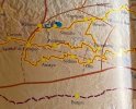
What Ender seems to be doing is the way that goes from Oña to a bit South of AdC. Here's from one of the photos you posted, Laurie, blown up - it shows both possibilities:
Screenshot_20240915_142149_Opera.jpg
 
Before the Camino: Your Pocket Guide to Prepare Your Body and Mind for the Camino
Thats a really interesting route.
It goes more to the south than the one I'm planning.
From close to Miranda De Ebro, I'll follow the Ebro river and this tout keeps going paralel to it. And both of them seem to be called Viejo.
I'll start my camino on October 3rd and keep you informed.
 
Oh, another possible route!! 😲
What we planned on this thread is the route that goes from Trespaderne direct to Aguilar de Campoo.

What Ender seems to be doing is the way that goes from Oña to a bit South of AdC. Here's from one of the photos you posted, Laurie, blown up - it shows both possibilities:
View attachment 177720
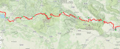
This is what I'll try to acomplish.
1726446965003.png
 
...and ship it to Santiago for storage. You pick it up once in Santiago. Service offered by Casa Ivar (we use DHL for transportation).
I'll start my camino on October 3rd and keep you informed.
Please!
From Frias on the route you're planning to walk, if you make your way to Oña, you can follow that more Southerly route.

Editing to add - when you get there, please let us know of the accommodation options for the part within 40km of AdC. There was something at Villanueva de la Nia, but that seems no longer to be open.
 
I have no idea! It goes though Oña, which looks really interesting. And maybe Poza de la Sal, too, though it's hard to tell from the map. And I vaguely remember it being a historical route.
 
Get a spanish phone number with Airalo. eSim, so no physical SIM card. Easy to use app to add more funds if needed.
Here is that discussion - Post 116, in this thread:
OsmAnd makes that simple to plot, at least in terms of the basic route, which could be easily tweaked.
Here you go:
The route I mapped out looks similar to what Ender is doing, but perhaps less circuitious.
 
Well, there is a way to go through both Oña and Trespaderne, if you follow @WestKirsty’s tracks. She went, I think, from Quintana Martín Galíndez to Oña via Frias and Tobera (see her wikiloc tracks with the title Camino Viejo (Alternativa); Qintana Martin Galindez-Oña). Then from Oña she went to Trespaderne (20 km) and from there the next day to Quintana de Valdivielso.

Thats a really interesting route.
It goes more to the south than the one I'm planning.
From close to Miranda De Ebro, I'll follow the Ebro river and this tout keeps going paralel to it. And both of them seem to be called Viejo.
I'll start my camino on October 3rd and keep you informed.
OOOOOHHHH, can’t wait to see how it goes for you. I’m hoping, fingers crossed, that the stars align and I can walk the Viejo early next summer. We will see!
 
A bit off-topic sorry -- but whilst the route shown for El Viejo Camino on this map looks solid enough, its depiction of the Roman roads in northern Spain is laughably incorrect, and some of the very old Camino routes in those regions are mysteriously absent -- and that cannot be at all helpful for anyone planning similar.

It mysteriously depicts some secondary Roman roads as being principal ones, but leaves out the major route from the Via Aquitana to Burgos (roughly equivalent to the modern Vasco Interior), and a main road stretched between Burgos and Logroño, then headed towards Girona and Rome (equivalent to the Camí Catalàn via Lleida).

Its depiction of the roads in Western Galicia is particularly egregious -- the main road there was the basis of what became the Portuguese Central, not the bizarre concoction they seem to have come up with, to try and present Fisterra as some kind of ancient way. No, the road going there was a tertiary dirt track towards various fishing villages.

Sigh. At least they got the complicated Arzúa - Lugo- León section of the roads mostly right ...

More on-topic, these mistakes have led them to leave out of their route mapping the section of the Vasco Interior between San Sebastián and Vitoria. Also it leaves out options northward from Logroño up the Ebro river valley.

It's BTW worth remembering in these projects to recreate "old" Camino routes that northern Spain was only intermittently interdicted to Christian pilgrims in Muslim-ruled areas.
 
Last edited:
A great book to listen to while training for the Camino or to relive the experience!
I have no idea! It goes though Oña, which looks really interesting. And maybe Poza de la Sal, too, though it's hard to tell from the map. And I vaguely remember it being a historical route.
According to the 1990s French & Spanish IGN map of historical Camino routes, that one leads down to Frómista (probably via Aguilar de Campoo -- it's a map of Europe so lacking in fine detail).
 
Maybe it has something to do with that monk Gundisalvo who walked in the 10/11C?
 
Train for your next Camino on California's Santa Catalina Island March 30 to April 2

❓How to ask a question

How to post a new question on the Camino Forum.

Forum Zoom Chats

Join our Camino Forum Zoom chats every Tuesday. See the next one here.

❓How to ask a question

How to post a new question on the Camino Forum.

Forum Rules

Forum Rules

Camino Updates on YouTube

Camino Conversations

Most downloaded Resources

This site is run by Ivar at

in Santiago de Compostela.
This site participates in the Amazon Affiliate program, designed to provide a means for Ivar to earn fees by linking to Amazon
Official Camino Passport (Credential) | 2024 Camino Guides
Back
Top