• Remove ads on the forum by becoming a donating member. More here.

Search 69,459 Camino Questions

Wikiloc or alternative for planning

Time of past OR future Camino
Inglès April 2023
Primitivo July 2023
I'm currently trying to plan my Germany to Santiago route in a little more detail. Specifically what I want to do is create a linear route marked out in km (roughly 20km spacing) with the town's etc marked on it, much as you see in many of the guide books.
Not a stages plan per se because that fixes me in too much. I am well aware that some days I won't want to bother much with walking so I'll do perhaps just 15 or 20 k's, others the terrain's good and I'm feeling great, so I'll do 40. It's not solely about accommodation because I fully intend to free camp at times.

Until now I have used mapy.cz, but that's really annoying because you have to guesstimate how far ahead something is before you can measure it. If that doesn't work, delete and restart.

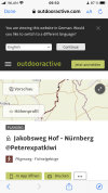
I thought wikiloc would be the go but it's bloody useless. I've just tried it for a section here in Germany, and rather than take me four kilometers down the road on the Jakobsweg, it's taken me on a 27 km route around town to get to the same point. It clearly is not programmed with the Jakobsweg!

Or am I missing something?

Alternatives?
 
The focus is on reducing the risk of failure through being well prepared. 2nd ed.

not sure how up to date it is and within Spain IIRC but was handy for me when I was starting out planning.

edit to say they seem to have added Italy but no Germans yet :p
 
Last edited:
Thanks, but unfortunately this is only good for the mainstream camino's in Spain and a handful of trails in Italy as far as I can see.
I'm coming from a little further afield and whilst walking the Camino, certainly not on the ones that they list.

Thanks anyway though! :)
 
€2,-/day will present your project to thousands of visitors each day. All interested in the Camino de Santiago.
Thanks, but unfortunately this is only good for the mainstream camino's in Spain and a handful of trails in Italy as far as I can see.
I'm coming from a little further afield and whilst walking the Camino, certainly not on the ones that they list.

Thanks anyway though! :)
Np Peter it will probably be useful to other route planners and the way the forum points to similar posts others might find
 
I thought wikiloc would be the go but it's bloody useless. I've just tried it for a section here in Germany, and rather than take me four kilometers down the road on the Jakobsweg, it's taken me on a 27 km route around town to get to the same point. It clearly is not programmed with the Jakobsweg!
Hi, @Peterexpatkiwi,

I think you should give wikiloc another try. Wikiloc is a “crowd-sourced” treasure trove of trails that have been recorded by users. There is no “it.” There are multiple tracks for any section of any camino I have ever walked. You must have followed the track of someone who went on a 27 km route around your town, and not someone who was walking the Jakobsweg.

I could go on and on about how I use wikiloc, but probably the best thing is to first help you find some good tracks for the section you want to walk. I’m not sure how popular wikiloc is in Germany, but I am betting there are some Jakobsweg tracks loaded there. Give me some towns that are on the stage you want to walk.

Wikiloc is by far the best go-to source for camino tracks in Spain, but using it is more time consuming than just downloading one app and following the one option it gives you. I always have several alternatives for every stage I walk on a remote camino, so I can flip back and forth if problems arise. But that’s getting ahead of things, the first thing is for you to find some tracks!
 
Join Camino Cleanup: Logroño to Burgos May 2025 and Astorga to O'Cebreiro in June.
Thanks.
Ok, Hof - Nürnberg for example.
If I start at the northern end of the train station I'm practically on the Jakobsweg. But rather than take me across the tracks and out the far side on the Jakobsweg it chooses some other trail, circling completely around Hof. It's probably a lovely trail and the distance is much the same but whenever possible I wish to stay on the Camino.

I just tried to go from that northern point (CNR of Wilhelm Str / Marienstraße) to a tiny village called Osseck. (3km). It came up with "we couldn't find a trail in this place, please try again in a different location". Yet the camino goes directly from one point to the other.

If I try from the same point to Helmbrechts it takes me on a 27 km journey, rather than 21km on the Camino.
 
I have used alltrails to create the trail and then downloaded it to organic maps were I can add in key locations eg shop, bar, water etc. It's a bit cumbersome but it was the best solution I found planning a camino from Ireland. Unfortunately, I don't think there is a way to create a map on a smartphone using alltrails - only on a computer, but it can be accessed on a smartphone and downloaded.
It does allow for them to auto select the best route for a variety of activities eg hiking and cycling, but also let's you directly drawn on too (if for example a shortcut path isn't on there map but you know it exists)
 
Ideal sleeping bag liner whether we want to add a thermal plus to our bag, or if we want to use it alone to sleep in shelters or hostels. Thanks to its mummy shape, it adapts perfectly to our body.

€46,-
Thanks.
Ok, Hof - Nürnberg for example.
If I start at the northern end of the train station I'm practically on the Jakobsweg. But rather than take me across the tracks and out the far side on the Jakobsweg it chooses some other trail, circling completely around Hof. It's probably a lovely trail and the distance is much the same but whenever possible I wish to stay on the Camino.

I just tried to go from that northern point (CNR of Wilhelm Str / Marienstraße) to a tiny village called Osseck. (3km). It came up with "we couldn't find a trail in this place, please try again in a different location". Yet the camino goes directly from one point to the other.

If I try from the same point to Helmbrechts it takes me on a 27 km journey, rather than 21km on the Camino.
These tracks look like “real” jakobsweg tracks. I just don’t know anything about the stages and can’t fiddle with the map to see what else is there.


There are two ways to search for tracks on wikiloc. One is by using words to search for the tracks, based on your assumptions of starting and ending points, I just searched for nuremberg jakobsweg and found this.

The other way is to use the map. You can put a circle on two different points on their map and find all the trails that are recorded that pass through those two spots. That is a really terrific search tool if you are going to go off-camino (I used it many times this past spring to detour from the Invierno or the Serrana to Roman ruins, waterfalls, monasteries). But this is a feature only available if you are a premium user.
 
But rather than take me across the tracks and out the far side on the Jakobsweg it chooses some other trail, circling completely around Hof.
Maybe I haven’t explained myself clearly. When you use wikiloc, you have to search for and choose a track to follow. You can see where the track goes when you bring it up on your phone or computer. You must have chosen a track that walked a circle around Hof and not a Jakobsweg track.

What was your search term or terms? I really think this is worth some effort to figure out, because wikiloc in Spain cannot be beat. Ánimo!
 
These tracks look like “real” jakobsweg tracks. I just don’t know anything about the stages and can’t fiddle with the map to see what else is there.


There are two ways to search for tracks on wikiloc. One is by using words to search for the tracks, based on your assumptions of starting and ending points, I just searched for nuremberg jakobsweg and found this.

The other way is to use the map. You can put a circle on two different points on their map and find all the trails that are recorded that pass through those two spots. That is a really terrific search tool if you are going to go off-camino (I used it many times this past spring to detour from the Invierno or the Serrana to Roman ruins, waterfalls, monasteries). But this is a feature only available if you are a premium user.
Thanks. Yes I have signed up as a premium member (14-day free trial), and was trying method two ie between the two points. Those are the examples I've given above - 'Trail doesn't exist'.

I've also tried the first methodology and while they're occasionally there when somebody has uploaded them, for a lot of my route they either do not appear to follow the same route that I wish to follow (which my map and mapy.cz both show) or they do not exist.

Interestingly I've just tried logging in on my laptop to mapy.cz, it transpires that I can move along the trail utilizing my cursor and it gives me a running distance total - not something I can do on my phone. Plus an altitude profile option which is useful.

I normally use my laptop just for work etc, on the assumption that I am not going to have it with me on Camino!

Clearly I should have tried this sooner, because looking at it, it may well do pretty much everything I wish to achieve.

Still, I'm happy to consider other planning options- if somebody has a good suggestion, fire away!
 
Last edited:
The focus is on reducing the risk of failure through being well prepared. 2nd ed.
Once you decide which app you want to use, I would forget about all the others and concentrate on it. I know there are many options, but I long ago settled on wikiloc and have gotten pretty proficient. But there is a learning curve.

I found this one using the map, is it not going to the right place?

Sadly not, different route.
I've also tried the first methodology and while they're occasionally there when somebody has uploaded them, for a lot of my route they do not exist unfortunately.
I'll go back and edit this for future readers, basically I've found a couple however they don't follow what I understand (from a map) to be the Camino. Nor might I add mapy's tracks, which until now I have found ( over 350km) to be almost 100% accurate (allowing for paths to have occasionally been moved).

I think you're right, now I've found I can do most of what I wish on my laptop version of mapy, I might just continue with that unless something much better comes along.
 
There are so many mapping and navigation apps, the best one is often the one you're most familiar with. However it could be that Komoot would work for you. It's a German app, started I think as a bike routing app but includes hiking, running and mountaineering options. You will probably need to pay for premium to get the options required. I just tried some of the places you mentioned and hey presto it gave me a sensible looking route. There is also a "daily stages" option and a hiking map background if you pay the premium rate. Happy to answer questions if you're not convinced. Richard
 
3rd Edition. More content, training & pack guides avoid common mistakes, bed bugs etc
There are so many mapping and navigation apps, the best one is often the one you're most familiar with. However it could be that Komoot would work for you. It's a German app, started I think as a bike routing app but includes hiking, running and mountaineering options. You will probably need to pay for premium to get the options required. I just tried some of the places you mentioned and hey presto it gave me a sensible looking route. There is also a "daily stages" option and a hiking map background if you pay the premium rate. Happy to answer questions if you're not convinced. Richard
I agree with everything you say, with the one caveat that if @Peterexpatkiwi is hoping to use the app for caminos in Spain, Komoot might not be helpful. It may well be, I just don’t know. But something to find out before investing a lot of time in any app.
 
I like to use waymarkedtrails.org for tracks. You can download kml or gpx files for a huge number of routes. I use organic maps as my offline mapping app, which nicely displays kml files. I will say that I find it easier to use waymarkedtrails.org on my laptop rather than my phone, so I always try to download my routes at home first.
 
Perfect memento/gift in a presentation box. Engraving available, 25 character max.
Thanks. Yes I have signed up as a premium member (14-day free trial), and was trying method two ie between the two points. Those are the examples I've given above - 'Trail doesn't exist'.

I've also tried the first methodology and while they're occasionally there when somebody has uploaded them, for a lot of my route they either do not appear to follow the same route that I wish to follow (which my map and mapy.cz both show) or they do not exist.

Interestingly I've just tried logging in on my laptop to mapy.cz, it transpires that I can move along the trail utilizing my cursor and it gives me a running distance total - not something I can do on my phone. Plus an altitude profile option which is useful.

I normally use my laptop just for work etc, on the assumption that I am not going to have it with me on Camino!

Clearly I should have tried this sooner, because looking at it, it may well do pretty much everything I wish to achieve.

Still, I'm happy to consider other planning options- if somebody has a good suggestion, fire away!
You can add waypoints along the map to help you judge distance too in mapy.cz it is also really easy to modify the route which I have found to not be the case with so many other mapping tools.

See https://en.mapy.cz/s/gavucucusa as an example.

Also on the mobile app you can hit the two arrows at the bottom and see a list of the points along your route and the distances between them as well as an elevation profile.

Best of luck.

Thanks. Yes I have signed up as a premium member (14-day free trial), and was trying method two ie between the two points. Those are the examples I've given above - 'Trail doesn't exist'.

I've also tried the first methodology and while they're occasionally there when somebody has uploaded them, for a lot of my route they either do not appear to follow the same route that I wish to follow (which my map and mapy.cz both show) or they do not exist.

Interestingly I've just tried logging in on my laptop to mapy.cz, it transpires that I can move along the trail utilizing my cursor and it gives me a running distance total - not something I can do on my phone. Plus an altitude profile option which is useful.

I normally use my laptop just for work etc, on the assumption that I am not going to have it with me on Camino!

Clearly I should have tried this sooner, because looking at it, it may well do pretty much everything I wish to achieve.

Still, I'm happy to consider other planning options- if somebody has a good suggestion, fire
 
am I missing something?
I don't think so.
I don't use Wikiloc much at all, because I create my own route using OSMand, and downloaded tracks from the Dutch cofraternity. Sometimes I use Wikiloc to find specific tracks, but it's hunt and peck, hit and miss. And I really like OSMand. I'm used to it so that's what I use. As you say, Laurie:
Once you decide which app you want to use, I would forget about all the others and concentrate on it
There are no wrong answers here - it's very much a matter of preference.

Wikiloc is by far the best go-to source for camino tracks in Spain, but using it is more time consuming than just downloading one app and following the one option it gives you
Definitely my experience.
That said, if I want to go off piste I don't automatically use whatever option the app spits out, but make my own custom route - which takes a bit more time, but not much. I guess I don't want to just blindly follow what someone unknown did before me.
 
I don't agree with picking one app and then forgetting about all the rest. I expect that you'll find that several apps are useful and even necessary for creating a new composite route. I started out thinking that I wanted ONE APP, but then decided that this expectation wasn't very helpful. If you understand the different ways that you use each app, then it is not an problem to click on a different icon on your phone!

I am not anywhere near being expert in any of these programs or in mapping methods, but here are comments based on my experience...

Wikiloc - In the premium version. This is excellent as a crowdsourced supply of walking routes, whether officially recognized or random routes that individuals have walked. I doubt that there is a better source for obscure walks in Spain, which is why @peregrina2000 loves it. It is an outstanding source for kml and gpx files, which you can organize in lists, or you can view other people's lists. I also like it for tracking and recording my daily walks at home or on the Camino. It is great for navigating a single selected route when you are out walking but it is a pain to switch back and forth to compare alternate routes if you need to do this while walking. As a planning tool, it has serious limitations since you can only view one track at a time and it isn't easy to add waypoints or notes.

Organic Maps - I use this to create a personal atlas and inventory of routes and my own comments on my phone, for reference at any time. It is very easy to use. I have "All Routes" from the Dutch confraternity downloaded and then add tracks of interest from other sources, mainly Wikiloc. I can easily add waypoints and notes anywhere on the map (e.g. lodgings, hazards, commentary, etc.) I can zoom in and out, view all these routes at once, compare them. (Complaints: First, it is not designed for use on a computer. Second, I have some frustration with the management of the files on my phone, an Android, but have come to terms with my need for control and the fact that phone files are simply hard to manage.)

Google Maps - Can't be beat, for city walking and business information, or quick and dirty routes/distances between two points. But can't be trusted for best walking routes.

Google Earth - I often use this for planning on my computer. Again I have All Routes downloaded, and can add other routes to study on the big screen. In particular, I enjoy using Street View for following the route or finding intersections with Street View. But I find the "projects" organization to be confusing so I don't organize my files here or fully utilize the program.

Mapy.cz - This is a program of interest, but I haven't yet taken the time to study it. Since I have just finished my 2024 Camino, maybe I will take the next 10 months to look at it!
 
Perfect memento/gift in a presentation box. Engraving available, 25 character max.
I don't agree with picking one app and then forgetting about all the rest.
You’re right that I should have said that FOR ME the undoubtably best solution has been to pick one app, learn it well, and forget about the rest. Other people have different skills, interests, and patience and can easily manage several.

But I also think that for most of us, learning one app fairly well before branching out to others is the way to go. Peter seems to be at the very initial stages of figuring this out, and at this point I think that flipping around from one program to another is likely to cause a lot of frustration.
 
I also think that for most of us, learning one app fairly well before branching out to others is the way to go. Peter seems to be at the very initial stages of figuring this out, and at this point I think that flipping around from one program to another is likely to cause a lot of frustration.
I get your point, and have limited my own experimentation to the apps that I've mentioned. On getting started, though, one needs to have an idea of the strengths/features of different programs relative to what you want to do, in order to choose one (or more) to get started. When you get any new tool, you need to ask some questions to understand what the reasonable options are.

We would all like an all-purpose Swiss Army Knife of mapping, but I don't think the perfect one exists. Sometimes it makes more sense to buy a more modest knife combo, and get a separate cork screw and scissors. Just because they aren't attached doesn't mean they are harder to use. But you do need to know which one to use for what! 😂 .
 
🤣😂 Yes, that's mine, I created it yesterday once I discovered I could do a lot more on my laptop then was possible in the mobile app. That's why it has the same username.
But thank you very much for looking anyway!
you are funny 😆 at the bottom of the route you find the creator and thats not your name there.[
 
Last edited by a moderator:
Ideal sleeping bag liner whether we want to add a thermal plus to our bag, or if we want to use it alone to sleep in shelters or hostels. Thanks to its mummy shape, it adapts perfectly to our body.

€46,-
you are funny 😆 at the bottom of the route you find the creator and thats not your name there.[
61D2683B-FD7B-4145-8CAF-529C523DAA8C.png???? Ok, told you I’m new to this- when I open it this is what I saw!

Edited to add: in the woods of Homer Simpson "duuuh!" I've just realised - I thought this was in Mapy, it's not!
My humble apologies, told you I'm new to all this stuff..... 😣🤕.

Thanks!!
 
Last edited:
Get a spanish phone number with Airalo. eSim, so no physical SIM card. Easy to use app to add more funds if needed.
Hi Peter. Peg and I have been camping a few days and have had phone charging issues, now fixed. So just seen your request. If I understand things correctly you are looking for what you get with Mapy but on a phone. I believe OSMand will do the job for you.

I recently rewatched a video that seems to show how to use OSMand to do what you want. I think this is the one. My cellular data is expensive so I'm giving you this one without checking it out. I will do that when I get home. Anyway, it was one of the OSMand videos by Bart Eisenberg.

Creating and Using GPXs
YouTube video id: H5EEQYC0WLg
 
Last edited:
I agree with everything you say, with the one caveat that if @Peterexpatkiwi is hoping to use the app for caminos in Spain, Komoot might not be helpful. It may well be, I just don’t know. But something to find out before investing a lot of time in any app.
True to some extent in that komoot uses OSM for its mapping and OSM map quality varies across countries. However OSM in Europe is good, very good I'd say and caminos are certainly shown within the region. Perhaps the qualifier that it's a German app was irrelevant, it's an international company now.
 
Hi Peter. Peg and I have been camping a few days and have had phone charging issues, now fixed. So just seen your request. If I understand things correctly you are looking for what you get with Mapy but on a phone. I believe OSMand will do the job for you.

I recently rewatched a video that seems to show how to use OSMand to do what you want. I think this is the one. My cellular data is expensive so I'm giving you this one without checking it out. I will do that when I get home. Anyway, it was one of the OSMand videos by Bart Eisenberg.

Creating and Using GPXs
YouTube video id: H5EEQYC0WLg
OsmAnd is a great mapping / navigation app though perhaps to some extent it's for the cognoscenti. As an offshore surveyor, navigator, with 40 years experience I found it too complex, with too many options. That is both it's strength and weakness; get your head around the system then it's a wonderful & useful app otherwise you'll be chasing your tail, but then perhaps I'm just 10 years behind the times.
 
The focus is on reducing the risk of failure through being well prepared. 2nd ed.
OsmAnd is a great mapping / navigation app though perhaps to some extent it's for the cognoscenti. As an offshore surveyor, navigator, with 40 years experience I found it too complex
I agree. For Peter's use though it is probably not more complex than the alternatives he is testing and he can do what he wants with OSMand on a phone (if I understand his needs correctly).

For members looking for an easy to use general navigation app I used to recommend Maps.me but now a clone of it called Organic Maps (it's more private). For following a trail I recommend Wikiloc because it can signal an alert that you are off the trail. OSMand for those wanting the bells and whistles.

I think both @VNwalking and @woody66 use OSMand on my recommendation because of the features they need. I've cursed OSMand a lot though because I forget where to find the features I've used before.

I occasionally use Mapas de España. The basic documentation for it runs about 90-100 PDF pages --- in Spanish, of course.
 

❓How to ask a question

How to post a new question on the Camino Forum.

Most read last week in this forum

I have been walking the Camino Portugès starting in Porto. I am now in Caldas de Reis. One thing that disturbs me greatly as I walk the Camino is the amount of toilet trash littering the sides of...
Hi I’m just wondering if there are any apps to let you know the whereabouts of the washer/Dryers laundry room on the Camino Frances ? We are starting from Burgos where we left of last year ! By...
This is from Greek Travel Pages but ruling should apply to Spain and give pilgrims a better deal when booking accommodation court ruling
I don't know if you've come across this already but it is basically a watercolour travel journal along the Camino Frances by an artist called Joaquin Gonzalez Dorao. Every page brings to mind a...
Or not! Just for fun, anyone want to guess what this is, and why it's on the ground in a camino city? P.S. If you already know the answer, maybe give a hint or two but not spoilers!
NOTICE. I think as you will see in the following thread, AI is NOT the best Camino Planning Tool! I've been playing around with AI at work (ChatGPT and CoPilot) and use it sometimes for...

❓How to ask a question

How to post a new question on the Camino Forum.

Similar threads

Forum Rules

Forum Rules

Camino Updates on YouTube

Camino Conversations

Most downloaded Resources

This site is run by Ivar at

in Santiago de Compostela.
This site participates in the Amazon Affiliate program, designed to provide a means for Ivar to earn fees by linking to Amazon
Official Camino Passport (Credential) | 2024 Camino Guides
Back
Top