Search 74,075 Camino Questions

Bizarre discovery about the two route options between Saint-Jean and Roncesvalles

geraldkelly

Active Member
Time of past OR future Camino
Camino Francés, Vía de la Plata / Camino Sanabrés, Camino del Baztán, Camino Aragonés, Chemin du Puy
Everybody seems to assume that the route through Valcarlos is easier because its highest point (1057m) is lower than the highest point on the Napoleonic route (1427m).

While preparing the new version of my app I was recalculating the total ascent and descent on both these routes. This is calculated by taking the difference in altitude between each GPS point along the route and adding all the ascents and all the descents together, that way you get the real amount of climbing and descending involved, not just the change of altitude from one village to the next.

I discovered something I didn’t expect to find but which I had suspected having walked both of these routes several times. The Valcarlos route actually involves more climbing than the Napoleonic route despite being lower altitude.

Some stats

Napoleonic route: total ascent = 1465m, total descent = -695m
Valcarlos route: total ascent = 1530m, total descent = -758m

The difference between the two routes isn’t huge but it’s significant given that the Valcarlos route is usually described as the easier option. But actually it’s not that simple.

The key to this is the part from Saint-Jean to Valcarlos. This starts at 174m and ends at 366m. That makes a difference of 192m over 11.5km. So, 16m per km. It sounds pretty flat and I have to admit that in the past I’ve described it as being exactly that, pretty flat. But the reality is different, it actually ascents 529m and descends 337m. So it’s not flat at all but you tend not to notice it because it’s several small ascents and descents and you’ll usually walking it at the start of the day when you’re fresh and by the time you arrive into Roncesvalles at the end of the day you’re so exhausted from the climb that comes later in the day that you’ve completely forgotten when you did in the morning.

I'm attaching altitude profiles for both routes so you can see for yourself.

You can verify the figures above by calculating as follows: Saint-Jean altitude = 174m, Roncesvalles = 944m

174+1465-695 = 944
174+1530-758 = 946

(small difference due to the GPS track not being 100% accurate)
 

Attachments

  • altitude Napoleon.png.png
    altitude Napoleon.png.png
    6.8 KB · Views: 71
  • altitude Valcarlos.png
    altitude Valcarlos.png
    4.9 KB · Views: 67
The 2024 Camino guides will be coming out little by little. Here is a collection of the ones that are out so far.
gerardkelly,

Thanks for sharing your statistical discovery; now I know why I was pooped after the long hard slog up the Valcarlos route during 10 caminos.

As past pilgrim multitudes have done I, too, joyfully shouted my thanks when cresting the Ibaneta pass and then weeping in exhausted relief slowly 'floated' down to Roncesvalles to give thanks, sit down and soak my feet.
 
Last edited:
Everybody seems to assume that the route through Valcarlos is easier because its highest point (1057m) is lower than the highest point on the Napoleonic route (1427m).

While preparing the new version of my app I was recalculating the total ascent and descent on both these routes. This is calculated by taking the difference in altitude between each GPS point along the route and adding all the ascents and all the descents together, that way you get the real amount of climbing and descending involved, not just the change of altitude from one village to the next.

I discovered something I didn’t expect to find but which I had suspected having walked both of these routes several times. The Valcarlos route actually involves more climbing than the Napoleonic route despite being lower altitude.

Some stats

Napoleonic route: total ascent = 1465m, total descent = -695m
Valcarlos route: total ascent = 1530m, total descent = -758m

The difference between the two routes isn’t huge but it’s significant given that the Valcarlos route is usually described as the easier option. But actually it’s not that simple.

The key to this is the part from Saint-Jean to Valcarlos. This starts at 174m and ends at 366m. That makes a difference of 192m over 11.5km. So, 16m per km. It sounds pretty flat and I have to admit that in the past I’ve described it as being exactly that, pretty flat. But the reality is different, it actually ascents 529m and descends 337m. So it’s not flat at all but you tend not to notice it because it’s several small ascents and descents and you’ll usually walking it at the start of the day when you’re fresh and by the time you arrive into Roncesvalles at the end of the day you’re so exhausted from the climb that comes later in the day that you’ve completely forgotten when you did in the morning.

I'm attaching altitude profiles for both routes so you can see for yourself.

You can verify the figures above by calculating as follows: Saint-Jean altitude = 174m, Roncesvalles = 944m

174+1465-695 = 944
174+1530-758 = 946

(small difference due to the GPS track not being 100% accurate)
As one who has not walked either, because I began in Roncesvalles with my Spanish walking companion, I recognise that your discovery will surprise many pilgrims!!! All the while thinking the Valcarlos route was the easy option...
I just take off my camino hat to you intrepid pilgrims who begin in SJPdP! I faintly thought about doing just the day from SJPdP but why should I? I don't need to. Not when I can vicariously follow both routes via the Forum! I prefer to repeat el Perdón.
 
Ideal sleeping bag liner whether we want to add a thermal plus to our bag, or if we want to use it alone to sleep in shelters or hostels. Thanks to its mummy shape, it adapts perfectly to our body.

€46,-
Everybody seems to assume that the route through Valcarlos is easier because its highest point (1057m) is lower than the highest point on the Napoleonic route (1427m).

While preparing the new version of my app I was recalculating the total ascent and descent on both these routes. This is calculated by taking the difference in altitude between each GPS point along the route and adding all the ascents and all the descents together, that way you get the real amount of climbing and descending involved, not just the change of altitude from one village to the next.

I discovered something I didn’t expect to find but which I had suspected having walked both of these routes several times. The Valcarlos route actually involves more climbing than the Napoleonic route despite being lower altitude.

Some stats

Napoleonic route: total ascent = 1465m, total descent = -695m
Valcarlos route: total ascent = 1530m, total descent = -758m

The difference between the two routes isn’t huge but it’s significant given that the Valcarlos route is usually described as the easier option. But actually it’s not that simple.

The key to this is the part from Saint-Jean to Valcarlos. This starts at 174m and ends at 366m. That makes a difference of 192m over 11.5km. So, 16m per km. It sounds pretty flat and I have to admit that in the past I’ve described it as being exactly that, pretty flat. But the reality is different, it actually ascents 529m and descends 337m. So it’s not flat at all but you tend not to notice it because it’s several small ascents and descents and you’ll usually walking it at the start of the day when you’re fresh and by the time you arrive into Roncesvalles at the end of the day you’re so exhausted from the climb that comes later in the day that you’ve completely forgotten when you did in the morning.

I'm attaching altitude profiles for both routes so you can see for yourself.

You can verify the figures above by calculating as follows: Saint-Jean altitude = 174m, Roncesvalles = 944m

174+1465-695 = 944
174+1530-758 = 946

(small difference due to the GPS track not being 100% accurate)
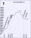
The biggest difference is WHEN the big climb occurs. Valcarlos does not need a Day 1 massive performance, unless you're doing it in a day.
In addition, Valcarlos can be easier if the road is used, providing an easier grade, (switchbacks), though a few extra steps to get to the valley rim just before Roncesvalles. By memory, I recall some level walking, very little descent, but mostly a gentle climb, until after Valcarlos, the ease of the previous day must be paid by increasing the grade for the next day.
 
For me, each route had an end-of-day challenge, on Valcarlos the killer climb in the second half, and on Napoleon the steep, toe-crunching descent at the end. My fondest memory was arriving via Valcarlos during a weather warning, in a cold, howling wind so strong that I was nearly blown off my feet at the pass, and being greeted by a warm "Hola!" as I opened the door at the Sabrina tavern. A total of eight pilgrims arrived in Roncesvalles that blustery November day, snow was falling at bedtime, and we awoke to a quiet winter wonderland.
 
Ideal sleeping bag liner whether we want to add a thermal plus to our bag, or if we want to use it alone to sleep in shelters or hostels. Thanks to its mummy shape, it adapts perfectly to our body.

€46,-
For me, each route had an end-of-day challenge, on Valcarlos the killer climb in the second half, and on Napoleon the steep, toe-crunching descent at the end. My fondest memory was arriving via Valcarlos during a weather warning, in a cold, howling wind so strong that I was nearly blown off my feet at the pass, and being greeted by a warm "Hola!" as I opened the door at the Sabrina tavern. A total of eight pilgrims arrived in Roncesvalles that blustery November day, snow was falling at bedtime, and we awoke to a quiet winter wonderland.
Thank you for your honesty. I recently walked the Francis from Lourdes. I was really disappointed with comments on the forum that the Valcarlos was relatively flat. I walked it on 28th April, yes it snowed at Roncevalles that night, my first time in snow. It certainly is NOT flat as everyone states. I came home and looked more closely at the elevation profile they give you at St Jean and confirm what you are saying. I’m a 65 yr old female from Australia, Valcarlos was high and tough, a lot of people are interested in my walk, I’m being honest with them and not filling them with dreams of a lovely pleasant flat.
I came home bewildered at how I made it to Santiago, only by the grace of god.
So many people dropped out, please be honest with the difficulties of the walk.
Oops-Wrong date - I didn’t walk that fast-31st March I was walked the Valcarlos
 
So many people dropped out, please be honest with the difficulties of the walk.
"honest"? I think the problem is that many people walk with very different levels of fitness and preparation. What I find fairly straightforward may be painfully demanding for others - or vice versa. It is not dishonest for someone to report that they personally found the walk quite easy even if others may struggle. The bare facts about distances and elevations are easy enough to find but not all Camino walkers have the prior experience to make a reliable judgement on what those figures will mean in practice for them individually. I've never read or heard anyone describing the Valcarlos route as "flat". A glance at a topographic map or an elevation profile for the route should make it clear that such a notion is false.
 
The one from Galicia (the round) and the one from Castilla & Leon. Individually numbered and made by the same people that make the ones you see on your walk.
Aha! As I suspected. Last year I came to the moral support of a woefully unprepared Pilgrim on the "easy" route. She hadn't done much research and was under the impression that it was flat. I'm waiting for @Rick of Rick and Peg to now chime in with the Naismith rule or some other computation proving that the Vacarlos route is actually TWICE as hard as the regular route. ;)
 
... I think the problem is that many people walk with very different levels of fitness and preparation....
Oh, thank you, @Bradypus - I SO agree! I've walked both Napolean and Val Carlos twice, and the next time I do it - this Fall, maybe, I SHALL walk over Napolean again - it was far easier FOR ME, an almost-old-lady, than Val Carlos.
 
I found the Valcarlos route a real grind once you hit the switchbacks. Not a fiddle at all. I have text to walk the Napoleon - might do so next time. I was 59 at the time.
 
The 2024 Camino guides will be coming out little by little. Here is a collection of the ones that are out so far.
For me the difficulty of the Valcarlos route was the lack of water after Valcarlos plus the steeper climb being at the end of the day. When/if I do that route again, I’d spend the night in Valcarlos.
 
For me the difficulty of the Valcarlos route was the lack of water after Valcarlos plus the steeper climb being at the end of the day. When/if I do that route again, I’d spend the night in Valcarlos.
Thank you, I did think about not adding another comment, but, perhaps I should make it clear that I was not comparing the two routes. My map reading goes-if the line is straight across it's pretty flat, if it goes up at an angle it's pretty tough. When I returned home I scanned the printout and read the elevation levels and realised how I had misread the printout. However, on the forum many people do say the Valcarlos is relatively flat compared to the Napoleon (I guess that's where I get the 'flat' from).
Also, I discovered many people on the walk were from mountainous regions, I personally have no trouble going down steep paths, I noticed some mountain people did, very fortunate are the people who can do both up and down with no additional effort.
 

Attachments

  • 1652680098101.png
    1652680098101.png
    85.7 KB · Views: 34
The biggest difference is WHEN the big climb occurs. Valcarlos does not need a Day 1 massive performance, unless you're doing it in a day.
In addition, Valcarlos can be easier if the road is used, providing an easier grade, (switchbacks), though a few extra steps to get to the valley rim just before Roncesvalles. By memory, I recall some level walking, very little descent, but mostly a gentle climb, until after Valcarlos, the ease of the previous day must be paid by increasing the grade for the next day.
That's it ! I am grabbing a cab to Ibaneta and THEN I'll float down to RONCESVALLES WITH OBLIGATORY SMIRK. :) At 84 I think I am entitled to a few short cuts and besides I've done it all before so guilt and gloom can go hang!

Keep on truckin kiddies! :)

Samarkand.
 
Perfect memento/gift in a presentation box. Engraving available, 25 character max.
Winter route definately more gentle physically…..but visually…?…Napoleon is it Talk about kicking off a Camino with a bang. Just look at the scenery last July🙏🏼

((Note that I would choose Valcarlos in uncertain weather.))


Everybody seems to assume that the route through Valcarlos is easier because its highest point (1057m) is lower than the highest point on the Napoleonic route (1427m).

While preparing the new version of my app I was recalculating the total ascent and descent on both these routes. This is calculated by taking the difference in altitude between each GPS point along the route and adding all the ascents and all the descents together, that way you get the real amount of climbing and descending involved, not just the change of altitude from one village to the next.

I discovered something I didn’t expect to find but which I had suspected having walked both of these routes several times. The Valcarlos route actually involves more climbing than the Napoleonic route despite being lower altitude.

Some stats

Napoleonic route: total ascent = 1465m, total descent = -695m
Valcarlos route: total ascent = 1530m, total descent = -758m

The difference between the two routes isn’t huge but it’s significant given that the Valcarlos route is usually described as the easier option. But actually it’s not that simple.

The key to this is the part from Saint-Jean to Valcarlos. This starts at 174m and ends at 366m. That makes a difference of 192m over 11.5km. So, 16m per km. It sounds pretty flat and I have to admit that in the past I’ve described it as being exactly that, pretty flat. But the reality is different, it actually ascents 529m and descends 337m. So it’s not flat at all but you tend not to notice it because it’s several small ascents and descents and you’ll usually walking it at the start of the day when you’re fresh and by the time you arrive into Roncesvalles at the end of the day you’re so exhausted from the climb that comes later in the day that you’ve completely forgotten when you did in the morning.

I'm attaching altitude profiles for both routes so you can see for yourself.

You can verify the figures above by calculating as follows: Saint-Jean altitude = 174m, Roncesvalles = 944m

174+1465-695 = 944
174+1530-758 = 946

(small difference due to the GPS track not being 100% accurate)
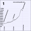
 
I used GPS tracks and gpsvisualizer.com to come to much the same conclusion.
I have to start by saying that I don't have personal experience walking either. But looking at Rick's visualization, it seems obvious to me that the Napoleon route is tougher than the Valcarlos route, despite the Valcarlos route having more total climb and descent altitude change. Because a long, sustained climb is much tougher than the same altitude gain spread out with flat spaces or descents in between. The same for descent. A long, sustained steep descent is much tougher than a series of much shorter, less steep descents with breaks in between. Napoleon has much more in the way of long, sustained ascents, saving its descent to the end where it is a much longer steep descent.
 
Everybody seems to assume that the route through Valcarlos is easier because its highest point (1057m) is lower than the highest point on the Napoleonic route (1427m).

While preparing the new version of my app I was recalculating the total ascent and descent on both these routes. This is calculated by taking the difference in altitude between each GPS point along the route and adding all the ascents and all the descents together, that way you get the real amount of climbing and descending involved, not just the change of altitude from one village to the next.

I discovered something I didn’t expect to find but which I had suspected having walked both of these routes several times. The Valcarlos route actually involves more climbing than the Napoleonic route despite being lower altitude.

Some stats

Napoleonic route: total ascent = 1465m, total descent = -695m
Valcarlos route: total ascent = 1530m, total descent = -758m

The difference between the two routes isn’t huge but it’s significant given that the Valcarlos route is usually described as the easier option. But actually it’s not that simple.

The key to this is the part from Saint-Jean to Valcarlos. This starts at 174m and ends at 366m. That makes a difference of 192m over 11.5km. So, 16m per km. It sounds pretty flat and I have to admit that in the past I’ve described it as being exactly that, pretty flat. But the reality is different, it actually ascents 529m and descends 337m. So it’s not flat at all but you tend not to notice it because it’s several small ascents and descents and you’ll usually walking it at the start of the day when you’re fresh and by the time you arrive into Roncesvalles at the end of the day you’re so exhausted from the climb that comes later in the day that you’ve completely forgotten when you did in the morning.

I'm attaching altitude profiles for both routes so you can see for yourself.

You can verify the figures above by calculating as follows: Saint-Jean altitude = 174m, Roncesvalles = 944m

174+1465-695 = 944
174+1530-758 = 946

(small difference due to the GPS track not being 100% accurate)
Brilliant and if the mud is on the floor it is twice as hard as Napoleon.
 
...and ship it to Santiago for storage. You pick it up once in Santiago. Service offered by Casa Ivar (we use DHL for transportation).
I have to start by saying that I don't have personal experience walking either. But looking at Rick's visualization, it seems obvious to me that the Napoleon route is tougher than the Valcarlos route, despite the Valcarlos route having more total climb and descent altitude change. Because a long, sustained climb is much tougher than the same altitude gain spread out with flat spaces or descents in between. The same for descent. A long, sustained steep descent is much tougher than a series of much shorter, less steep descents with breaks in between. Napoleon has much more in the way of long, sustained ascents, saving its descent to the end where it is a much longer steep descent.
David with all due respect you are wrong.
The bottom of the valley , the climb on unused paths compared with over the top , add a different dimension , especially when it’s raining
We have had to stop at Valcarlos twice because of the situation.
 
"honest"? I think the problem is that many people walk with very different levels of fitness and preparation. What I find fairly straightforward may be painfully demanding for others - or vice versa. It is not dishonest for someone to report that they personally found the walk quite easy even if others may struggle. The bare facts about distances and elevations are easy enough to find but not all Camino walkers have the prior experience to make a reliable judgement on what those figures will mean in practice for them individually. I've never read or heard anyone describing the Valcarlos route as "flat". A glance at a topographic map or an elevation profile for the route should make it clear that such a notion is false.
It's a fact that personal fitness levels determine how easy or difficult a climb will be. However, some posts make no mention of that when describing their own journey as 'easy', so it can be misleading, and thus potentially risky for those no longer young or not of optimal fitness.

As a matter of fact I am one of those that thought the Valcarlos route was a flatter and thus easier option, probably due to reading various anecdotal accounts, and maybe even the famous guide book. But I know better now.
 
There are supposed to be two differences. 1 is when the climb occurs - at the beginning vs the end. The other is the gradient of the climb - and supposedly Roncesvalles is more steep - especially up until Orisson. That gradient is supposedly what makes the Napoleon route harder. Of course - I have not done both climbs, nor have I truly researched whether or not these statements are actually true. They are just my understanding about why Napoleon is claimed to be harder. But for me - doing the climb at the end of the day is worse than the beginning of the day - so that right there makes Napoleon route better for me.
 
The one from Galicia (the round) and the one from Castilla & Leon. Individually numbered and made by the same people that make the ones you see on your walk.
Everybody seems to assume that the route through Valcarlos is easier because its highest point (1057m) is lower than the highest point on the Napoleonic route (1427m).

While preparing the new version of my app I was recalculating the total ascent and descent on both these routes. This is calculated by taking the difference in altitude between each GPS point along the route and adding all the ascents and all the descents together, that way you get the real amount of climbing and descending involved, not just the change of altitude from one village to the next.

I discovered something I didn’t expect to find but which I had suspected having walked both of these routes several times. The Valcarlos route actually involves more climbing than the Napoleonic route despite being lower altitude.

Some stats

Napoleonic route: total ascent = 1465m, total descent = -695m
Valcarlos route: total ascent = 1530m, total descent = -758m

The difference between the two routes isn’t huge but it’s significant given that the Valcarlos route is usually described as the easier option. But actually it’s not that simple.

The key to this is the part from Saint-Jean to Valcarlos. This starts at 174m and ends at 366m. That makes a difference of 192m over 11.5km. So, 16m per km. It sounds pretty flat and I have to admit that in the past I’ve described it as being exactly that, pretty flat. But the reality is different, it actually ascents 529m and descends 337m. So it’s not flat at all but you tend not to notice it because it’s several small ascents and descents and you’ll usually walking it at the start of the day when you’re fresh and by the time you arrive into Roncesvalles at the end of the day you’re so exhausted from the climb that comes later in the day that you’ve completely forgotten when you did in the morning.

I'm attaching altitude profiles for both routes so you can see for yourself.

You can verify the figures above by calculating as follows: Saint-Jean altitude = 174m, Roncesvalles = 944m

174+1465-695 = 944
174+1530-758 = 946

(small difference due to the GPS track not being 100% accurate)
That makes huge sense to me! I found the Valcarlos route excruciating in the afternoon. So much climbing, I just want prepared for it.
 
The issue as Gerald points out is not just the peak elevation reached while walking uphill. The correct measurement on a route is its TOTAL elevation gain. That means that along a route, it how much you go up and down hills BEFORE you get to the top, as well as how much elevation is gained from the base of the hill to the summit or top.

Valcarlos has more ups and downs elevation changes PLUS the elevation gain to the top. Napoleon has far fewer ups and downs, and those are pretty minimal ups and downs when compared to those on Valcarlos..

Napoleon is basically a continuous, straight uphill slog. While Gerald is correct as far as it goes, if a high quality precision instruments were used by trained surveyors and geo-cartographers, my guess is that Valcarlos has total elevation gain that is higher than Napoleon's.

One individual (with a decent stated fitness level), walks each route. When s/he hikes both, the Napoleon and Valcarlos magically have the same exact walking surface and weather conditions. The result will likely find that overall energy output is greater on Valcarlos, but that the energy output used is more evenly distributed along Napoleon.
 
Last edited:
I have chosen the Valcarlos route twice because I enjoyed the variety of terrain and my overnight stay there was at more of a halfway point rather than having to end my day early at Orrison. If I choose to walk the Frances again, I "may" try the Napoleon if weather permits and if I can get a reservation at the new Borda albergue, which is a bit farther up the way.
 
Get a spanish phone number with Airalo. eSim, so no physical SIM card. Easy to use app to add more funds if needed.
I have walked the Napoleon twice and the Valcarlos once, due to poor weather on the Napoleon. Enjoyed both routes very much.

As thé élévations show, the Valcarlos is definitely not flat. Nor, in experience, is it easy, by comparison. In relation to the Napoleon route, I agree with what some others have commented. The first 8kms to Orisson is a tough unrelenting climb. The rest of the climb is gentler. The long steep descent can be tough on the knees. But the Valcarlos is a continuous climb almost all day.

And I also agree with this from Dave.

The result will likely find that overall energy output is greater on Valcarlos, but that the energy output used is more evenly distributed along Napoleon.

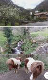
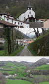
The other thing I’d mention - which perhaps someone more knowledgeable can chime in on. When we walked the Valcarlos in 2013 we found it to be a beautiful route (though not as spectacular as Napoleon route on a clear day). Some people comment on the amount of road walking (sometimes made dangerous with traffic) on the Valcarlos - but I recall only a short section of busy road with much of the path through woodlands and beside a river / steam. Did we take a wrong path or are there in fact two ways to walk the Valcarlos? 😎
 
Last edited by a moderator:
One individual (with a decent stated fitness level), walks each route. When s/he hikes both, the Napoleon and Valcarlos magically have the same exact walking surface and weather conditions.
Thanks for volunteering Dave; it has saved me from nominating you. I can't count the number of times I almost have done so on this thread. :)
 
but I recall only a short section of busy road with much of the path through woodlands and beside a river / steam. Did we take a wrong path or are there in fact two ways to walk the Valcarlos?
I found the Valcarlos route to be delightful in the Spring of 2015 and 2017. Like you, @anamcara, I found the road walking extremely minimal as I recall. The woodlands, bubbling brook, and sweeping views were all lovely.
 
€2,-/day will present your project to thousands of visitors each day. All interested in the Camino de Santiago.
I found the Valcarlos route to be delightful in the Spring of 2015 and 2017. Like you, @anamcara, I found the road walking extremely minimal as I recall. The woodlands, bubbling brook, and sweeping views were all lovely.
That’s good to have that confirmation, thanks Chrissy. I’m glad it wasn’t just me looking back with rose coloured glasses and I have had cause to ponder this recently.

Some friends recently asked me about the Valcarlos route as weather on the Napoleon was looking iffy for them. One was experienced, the other a first timer. I told them my impressions as a very pretty route but warned it was definitely no walk in the park. They hated it - reported back that there was way too much time walking on a busy road. It took them much longer than their previous time on the Napoleon and the whole experience was never to be repeated! I felt terrible that I may have misled them 😢 They said they didn’t think they went the wrong way as they had followed the Brierley guide. So I wasn’t really sure what to say except ‘sorry’!
 
Last edited by a moderator:
@anamcara, well, that's a bummer for sure.
I was very excited and enthralled being in Spain, especially for the first time, and I absolutely loved all aspects of the Valcarlos route. I didn't mind the road walking as there were not many vehicles and I recall some pretty cliffs to see...it's all what we are willing to make of it. Unfortunately your friends saw lemons, while I continually saw lemonade.
 
I have walked the Camino Frances three times. For the first two I walked the Napoleon. On my most recent (2016) I went by Valcarlos. I can't say that I found it significantly more or less difficult. I did think it was a less attractive route scenically. In the very unlikely event of my walking the Frances again I will probably go by the Napoleon if it is open. For me the main plus point of the Valcarlos route was how quiet it was. On a day when around 400 people left SJPDP I only saw about half a dozen other walkers. Arriving in the pandemonium of the reception area in Roncesvalles was a shock to the system after a pleasant day's mostly solitary walking!
 
Train for your next Camino on California's Santa Catalina Island March 30 to April 2
@anamcara, well, that's a bummer for sure.
I was very excited and enthralled being in Spain, especially for the first time, and I absolutely loved all aspects of the Valcarlos route. I didn't mind the road walking as there were not many vehicles and I recall some pretty cliffs to see...it's all what we are willing to make of it. Unfortunately your friends saw lemons, while I continually saw lemonade.
Possibly but that’s not really their way. They are very positive and grateful people, which is why I take heed of their experience. I genuinely think they walked a different way to me - at least for a significant distance. And I have read comments on this forum more than a few times before about busy road waking and traffic on the Valcarlos - so I do think there is something to this idea that some people end up staying on the road, perhaps missing a sign or signs to take you to the more scenic and peaceful path.
 
Possibly but that’s not really their way. They are very positive and grateful people, which is why I take heed of their experience. I genuinely think they walked a different way to me - at least for a significant distance. And I have read comments on this forum more than a few times before about busy road waking and traffic on the Valcarlos - so I do think there is something to this idea that some people end up staying on the road, perhaps missing a sign or signs to take you to the more scenic and peaceful path.
Yes, it could be they missed the turnoff into the woods with the meandering brook down in the ravine. Even so, I enjoyed staying overnight at the albergue in the cute town itself which they wouldn't have missed, unless they possibly walked the whole route in one long day.
Screenshot_20220522-173612~2.png
Screenshot_20220522-173435~2.png
 
the cute town itself which they wouldn't have missed, unless they possibly walked the whole route in one long day.
Yes, they walked in one day, as did I. Anyhoo, enough of my pondering about this. Didn't mean to hijack the thread - just have been curious about my experience (and yours) versus theirs and others who've commented on the busy road and traffic.
 
Perfect memento/gift in a presentation box. Engraving available, 25 character max.
Yes, it could be they missed the turnoff into the woods with the meandering brook down in the ravine. Even so, I enjoyed staying overnight at the albergue in the cute town itself which they wouldn't have missed, unless they possibly walked the whole route in one long day.
We stayed in the pouring rain in the alberque , alone with clothes drying everywhere.
The other occasions were spent in a lovely pension down the road from the bar in the towns centre.
It was beautiful.
 
That’s good to have that confirmation, thanks Chrissy. I’m glad it wasn’t just me looking back with rose coloured glasses and I have had cause to ponder this recently.

Some friends recently asked me about the Valcarlos route as weather on the Napoleon was looking iffy for them. One was experienced, the other a first timer. I told them my impressions as a very pretty route but warned it was definitely no walk in the park. They hated it - reported back that there was way too much time walking on a busy road. It took them much longer than their previous time on the Napoleon and the whole experience was never to be repeated! I felt terrible that I may have misled them 😢 They said they didn’t think they went the wrong way as they had followed the Brierley guide. So I wasn’t really sure what to say except ‘sorry’!
The Camino basically runs parallel to the road, although at a good distance in most places, but there are at least three places where if you weren't paying attention you could miss the Camino and end up walking on the road for quite a long time. The only road walking I remember was about 5km immediately after Valcarlos.
 
The first edition came out in 2003 and has become the go-to-guide for many pilgrims over the years. It is shipping with a Pilgrim Passport (Credential) from the cathedral in Santiago de Compostela.
The Camino basically runs parallel to the road, although at a good distance in most places, but there are at least three places where if you weren't paying attention you could miss the Camino and end up walking on the road for quite a long time. The only road walking I remember was about 5km immediately after Valcarlos.
Thanks Gerald I’m sure that must be what happened with my friends and others who’ve written about the route being mainly on the road. 🙏
 
Fail to prepare? reduce your risk by buying this book full of practical info.
2nd ed.
This forum's @John Sikora created an eleven minute time lapse video of his walking from Valcarlos to Roncesvalles. Besides the video of his point of view you can see moving Xs of where he was at the time on a Brierley map and a Google Earth satellite view. This should give you an idea of how much road walking there is.

Clicking the arrow in the center below will play an embedded view of the video but clicking the title at the top should show you a larger version.
 
I have chosen the Valcarlos route twice because I enjoyed the variety of terrain and my overnight stay there was at more of a halfway point rather than having to end my day early at Orrison. If I choose to walk the Frances again, I "may" try the Napoleon if weather permits and if I can get a reservation at the new Borda albergue, which is a bit farther up the way.
Thank you, the comments about the Valcarlos route are informative. I am planning to commence my first Camino - Frances in early August this year. I have decided that flying to and from Madrid is my preferred way of travel between Australia (Adelaide South Australia) and Spain. I understand I can travel from Madrid to Valcarlos by bus. I note the comments about the Valcarlos route but I would like Valcarlos to be my actual starting point. I believe this would still be a more manageable starting point for me - a mid seventies, reasonably fit, regular walker over various terrain. Good wishes.
 
Thank you, the comments about the Valcarlos route are informative. I am planning to commence my first Camino - Frances in early August this year. I have decided that flying to and from Madrid is my preferred way of travel between Australia (Adelaide South Australia) and Spain. I understand I can travel from Madrid to Valcarlos by bus. I note the comments about the Valcarlos route but I would like Valcarlos to be my actual starting point. I believe this would still be a more manageable starting point for me - a mid seventies, reasonably fit, regular walker over various terrain. Good wishes.
Coleen Kathma,
Welcome to the forum!

For more information/tips on walking the historic Valcarlos route see this earlier post.

I like you often chose to walk the Valcarlos route at age 65 to 76.

Stay safe and Buen camino.
 
...and ship it to Santiago for storage. You pick it up once in Santiago. Service offered by Casa Ivar (we use DHL for transportation).
Thank you, the comments about the Valcarlos route are informative. I am planning to commence my first Camino - Frances in early August this year. I have decided that flying to and from Madrid is my preferred way of travel between Australia (Adelaide South Australia) and Spain. I understand I can travel from Madrid to Valcarlos by bus. I note the comments about the Valcarlos route but I would like Valcarlos to be my actual starting point. I believe this would still be a more manageable starting point for me - a mid seventies, reasonably fit, regular walker over various terrain. Good wishes.
You can get a bus from Pamplona to Valcarlos but it's the same bus that goes to Saint-Jean where everybody starts. Why don't you go to Saint-Jean and spend the night there and then walk to Valcarlos?
 
You can get a bus from Pamplona to Valcarlos but it's the same bus that goes to Saint-Jean where everybody starts. Why don't you go to Saint-Jean and spend the night there and then walk to Valcarlos?
Thank you for this information and suggestion. I've decided that starting a bit further along the path at Valcarlos is more manageable for me. Good wishes.
 
Give back to the Camino. Join us from Logroño to Burgos May 30 to June 8.

❓How to ask a question

How to post a new question on the Camino Forum.

Most read last week in this forum

Hi Friends Maybe a dumb question...? I am heading off on my first camino in late April (CF) and wondering about booking beds via Whatsapp. What is the protocol? Will the hostels require payment...
https://www.caminodesantiago.me/community/camino-photos/carraig-an-aifrinn-mass-on-the-camino.1218/
Hi friends - I walked the Camino in Sept/Oct '24 and went to the lovely singalong at the nuns in Carrion de los Condes. At the end of the singalong, they mentioned an email address that was posted...
Are there currently (or more specifically during the busier seasons) any regularly scheduled musical experiences along the CF that are open to pilgrims? Things like regularly scheduled choir...
Hola Camigos, Just wondering if anyone has ideas or info or best places to hang out stay over Easter weekend, between these two places please? I’m torn between staying somewhere quieter from the...
Hi, my little group of 4 is going to walk from Sarria to Santiago commencing on 28th March. We want to use luggage transfers every day, but I have been unable to pre-book online on any of the...

Forum Zoom Chats

Join our Camino Forum Zoom chats every Tuesday. See the next one here.

❓How to ask a question

How to post a new question on the Camino Forum.

Forum Rules

Forum Rules

Camino Updates on YouTube

Camino Conversations

Most downloaded Resources

This site is run by Ivar at

in Santiago de Compostela.
This site participates in the Amazon Affiliate program, designed to provide a means for Ivar to earn fees by linking to Amazon
Official Camino Passport (Credential) | 2024 Camino Guides
Back
Top