• ⚠️ Emergency contact in Spain - Dial 112 and AlertCops app. More on this here.
  • Remove ads on the forum by becoming a donating member. More here.

Search 74,075 Camino Questions

What's Old is New Again! "Ruta De Los Asturianos O Del Regañón" Trail to Santo Toribio

RumAndChupacabras

Veteran Member
Time of past OR future Camino
Jul-Sept 2019: Six weeks in Northern Spain.
Apr 2018 Asturias
May 2016 CP: Portuguese
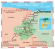
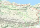
After much soul searching as to which Camino to take during our six weeks in Spain, it has become a passionate hope that we will re-trailblaze this seemingly forgotten, route. A few weeks ago, I made my first Wikiloc map for the Norte coastal portion of walking this route, exactly as it is depicted on the back of the Santo Toribio De Liébana Credential del Peregrino. We'll go for a slower paced walk of 10-15km a day. Since I'm really new at this form of map making please feel free to make helpful suggestions because, I still have to make maps for the rest of the trail. ;)

my map.....

back of the credential...

59690
 
Last edited:
A selection of Camino Jewellery
I love the idea, T! It would be fantastic to be able to make the Lebaniego connect back to the Norte without fully backtracking. It's too bad that this is largely restricted to the highway--I fear that it won't be the most enjoyable of walks for you. This is the challenge often of trying to recover historic routes; over time, those historic routes became modern highways!

I was curious if there was a way to do it without the roads. I don't see many options if you want to closely follow that itinerary. Trails might exist, but they don't show up on any of the map types that I have access to. It is possible, though, to follow an offroad approach through the hills that is almost entirely free of pavement. Here's a snapshot:

59735

This would be a much more rugged walk. The software says it's about 19km, but it doesn't always calculate distance in hills as accurately as one would like. Most of the tracks seem to be old dirt roads, but there are some footpaths as well, and those can be in highly varied states. Very little opportunities for water/supplies on this approach. The only places that really show up are Santa Eulalia (hotel La Casa del Jardín) and Alevia near the end (Hotel Casona d'Alevia). I don't think this is what you're looking for, but thought I'd share!
 
Last edited:
When interested in trails I don't bother with Google Maps which doesn't show them. I use the OSMand and Maps.me apps which do. You might be able to find obscure routes using these. They both use the Open Street Map database. OSMand shows more detail though. If you want to view a wikiloc track on top of the basic map OSMand can show GPX formatted tracks and maps.me can show KML and KMZ formats.
 
...and ship it to Santiago for storage. You pick it up once in Santiago. Service offered by Casa Ivar (we use DHL for transportation).
Yep, I use some of those and then additional "Outdoors" maps that include a lot more dirt roads and footpaths. Satellite, too, sometimes adds a useful layer. OSM is a nice start, but much less helpful for unpaved stuff.
 
OSM is a nice start, but much less helpful for unpaved stuff.
I find it terrific for trails but I have to admit I've only used it at home, not in Europe. It does rely on people submitting the data so it could be sparse in Spain. I've noticed that it is sparser on trail data in the American south than in the New England area.
 
Thank you's, @Dave and @Rick of Rick and Peg!

...This is the challenge often of trying to recover historic routes; over time, those historic routes became modern highways! I was curious if there was a way to do it without the roads. I don't see many options if you want to closely follow that itinerary. Trails might exist, but they don't show up on any of the map types that I have access to...

Dave, from what I see on that Coastal portion (Llanes to Colombres), you certainly appear to be spot on regarding highway! I'm just trying to keep the pueblo's the same as they are on the Credencial map. The rest of the trail/s (Panes to STL) are frequently foot trails...of which I've found many variables in Wikiloc because, I always use Satellite view when creating.

Is "outdoors", this? > https://www.outdoors.com

Rick o'R&P OOOOH...Maps.me looks interesting!

Is OSM, this? > https://www.openstreetmap.org

Finished another map yesterday and hope to complete one more, tomorrow. If interested you can see them through my Wikiloc link above. It's kind of exciting to see what new adventures lie ahead. 😁
 
Get a spanish phone number with Airalo. eSim, so no physical SIM card. Easy to use app to add more funds if needed.
Rick o'R&P OOOOH...Maps.me looks interesting!

Is OSM, this? > https://www.openstreetmap.org
I found maps.me easier to use than OSMand but it cannot do as much. With OSMand you can optionally get contour lines and offline wikipedia articles for shown locations for example. It uses more space for the data though as the offline maps are for bigger regions. For example I think maps.me broke up the state of North Carolina into seven sections but with OSMand you just downloaded the entire state.

OSM has that URL but I'm not sure if they are the developers of the OSMand app. The app does use the database that the Open Street Map project creates though.
 
Get a spanish phone number with Airalo. eSim, so no physical SIM card. Easy to use app to add more funds if needed.
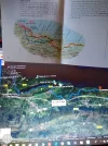
@Dave, Forgot that I have (permanently borrowed from my man 😁 ) your 2015 Northern Caminos book! Using the map on pages 124-125, I was able to see then, change my map for a 'more scenic' walk. Now to go back and change my other WIkiloc maps, using my new skilllset. Thanks!
59812
 
from what I see on that Coastal portion (Llanes to Colombres), you certainly appear to be spot on regarding highway! I'm just trying to keep the pueblo's the same as they are on the Credencial map.
What a great project you are tackling! Have you tried using the new "Search by Passing Area" feature available with Wikiloc Premium? It lets you put circles around two or more different areas and then see all the tracks passing through those areas. I just put in Llanes and Columbres and got 122 tracks that have been uploaded to Wikiloc that pass through both towns.
 
Last edited:
I just put in Llanes and Columbres and got 122 tracks that have been uploaded to Wikiloc that pass through the both towns
I'm new to Wikiloc and a basic member. When I do searches for two towns I get a list of tracks where either one or the other town (or both but not listed as a especially good hit) has its name in the track description. Would you please verify that the premium membership will show the tracks that pass through both towns at the top of the list.
 
Ideal pocket guides for during & after your Camino. Each weighs only 1.4 oz (40g)!
Would you please verify that the premium membership will show the tracks that pass through both towns at the top of the list.
Yes indeed, the results page will show all the uploaded tracks Wikiloc contains that pass through both areas you identified. For people wanting to build their own routes, it's a marvelous tool, especially for Spain, since Wikiloc originated there and has great coverage for Spain and Portugal. The first time you try it and see how useful is, you'll have a big smile on your face. You no longer have to know where a track starts or ends in order to make it come up in your search, nor do you have to know the title. You just sign up for Wikiloc premium ($9.99), go to the map search page, click on the words "Search by Passing Area" at the bottom of the map, and zoom in or out on the map to center the circle that appears over the first area that you want to walk from or to. Then click on the orange block that says "Search trails passing here." Next, click on the white block that says "Add passing area" and center your next circle over your target village. (You can add up to four passing areas.) All the trails that pass through both of your circles will then be listed on the side of the screen. You can display them on the map by clicking the "eye" symbol beside them. Full directions here. Have fun!
Elaine
 
Just saw that Premium price is for one year! 😲
 
Get a spanish phone number with Airalo. eSim, so no physical SIM card. Easy to use app to add more funds if needed.
Just saw that Premium price is for one year! 😲

Yikes is what I thought at first, too! There was a lot of discussion about the price for Premium in their online forum, and in the fourth message down, Kaixi, one of the Wikiloc programmers, explains their reasoning. It's mainly due to the cost of developing and maintaining the advanced features. After using them for a few months, I feel like I'm really getting my money's worth. Before, even with hours of searching, I never knew if I was missing a trail that would take me from Point A to Point B via a detour to some other site I wanted to visit; now I can figure it out in a flash. Or I can change my mind halfway through a route and immediately see all the other options available to me. Luckily, people can try Premium free for 14 days to see if the additional features are worth it to them. For people who are following a set route, the basic version is probably fine; for people who are developing their own routes, the premium version is a versatile tool.
 
Last edited:
@islandwalker, my bad for using an emoticon to try to emphasize my feeling. What I see is that wikiloc is 9.99 in Euros for 1 year. That's what my in amazement, wow look, was about. Now, let me check your hyperlink.
 

Attachments

  • Screenshot_20190624-201146.webp
    Screenshot_20190624-201146.webp
    93.7 KB · Views: 3
Get a spanish phone number with Airalo. eSim, so no physical SIM card. Easy to use app to add more funds if needed.
Starting to get a little nervous about this route or, lack thereof. Only 10 more days before we're off and I've been hard at work trying to map out and find accommodations. It wasn't until a couple of days ago that I realized...one wrong trail and we'd be heading into 'mountaineering'. So, I just DL Wikiloc Premium because, Live Tracking is sounding like a very good idea. Thank you @islandwalker for writing about it!
 
BTW @Rick of Rick and Peg, did you get the Premium Version, yet?
I plan to try it out with a 3 month subscription. Since I'll be needing it in October and November I'll wait until the start of September to pay for a membership. That will give me the membership's easier track searches feature to prepare my own routes in September.
 
Perfect memento/gift in a presentation box. Engraving available, 25 character max.
It wasn't until a couple of days ago that I realized...one wrong trail and we'd be heading into 'mountaineering'. So, I just DL Wikiloc Premium because, Live Tracking is sounding like a very good idea. Thank you @islandwalker for writing about it!
Sounds like you have a great walk planned! I'll be looking forward to reading posts from your experiences...
Elaine
 
Well...after weeks of hard working making maps and finding accomodations and making reservations, I hit a big problem. ☹ There is a 12km section of this original route which in no way safe to walk. Just as Dave mentioned in a reply above:
...This is the challenge often of trying to recover historic routes; over time, those historic routes became modern highways!...
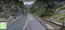
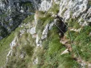
Zero shoulder, rock wall one side, rushing river, other side.
1563993477637.webp

I'm mentally fried and with only a week to go before we leave, disappointed. However, I just can't let go of the idea. Now that I've learned to "make the entire map FIRST, ya' big dummy!", it is my hope that once we have boots on the ground, I'll find a way around this problem.

SO, as I'm a firm believer in that there is nothing bad which, good can not come out of... ;)
 
Holoholo automatically captures your footpaths, places, photos, and journals.
...Can you find a way around it...
I tried this morning. The closest trail I could find to bypass this issue will add close to 70km to a 16km stage. My problem child comes on the Cuñaba to Bejes stage...where the trail from San Esteban merges into the N-621.
 
Holoholo automatically captures your footpaths, places, photos, and journals.
The closest trail I could find to bypass this issue will add close to 70km to a 16km stage. My problem child comes on the Cuñaba to Bejes stage...where the trail from San Esteban merges into the N-621.
Hmm...You've probably seen these trails already, but I'll send them in case either of them might be of help.
  1. bejes-tresviso-urdon 10.43 km, but rated "difficult" and the text mentions vertigo! "Spectacular crossing, from the Cantabrian town of Bejes to Tresviso and spectacular descent to Urdón on the N-621. I rated the crossing as difficult to warn those people who may suffer from vertigo or are not very expert on the mountain." Maybe you could email the author of the route to ask which leg the difficult part is on...? The photos give some hints too. It does indeed look spectacular, but those narrow sections may not be your cup of tea! Maybe they can be avoided by using the route below?
  2. VUELTA SIERRA DE COCÓN: SAN ESTEBAN - COLLADO GALABÍN - COLLADA JERMOSA - TRESVISO - PASÁ DEL PICAYO - SAN ESTEBAN (circular) Looks like an easier way from San Esteban to Treviso (5 km) and then the above trail from Tresviso to Bejes (also 5 km) for a total of 10 km from San Esteban to Bejes.
 
Last edited:
@RumAndChupacabras with @Rick of Rick and Peg and @Dave at your side, you are getting much better advice than I could ever give. I have not walked this route, and I am not a high tech peregrina, so you may ask why the heck am I posting. Just to say that I paid the $$$ to become a wikiloc premium member, and though I may only have used it several times, it was well worth it. If you think of it this way — would I pay $12 to find my way when I am horribly lost, the answer is obvious. The feature of being able to search the map and “trails passing through” was great. And one morning walking alone when I had taken a wrong turn and had no idea where I was, it was invaluable for me to be able to get on my phone and find what I needed to find when I didn’t have the GPS tracks on my Garmin. I may not be thinking of this the way an economist would, but for me the safety blanket feature was extremely comforting. Sort of like the reason why I buy travel insurance and hope I never have to use it.

But more importantly — this looks like a great camino, please keep us posted!
 
...You've probably seen these trails already, but I'll send them in case either of them might be of help...difficult to warn those people who may suffer from vertigo or are not very expert on the mountain...
E, you are a dear! Wait until you see a couple of the pix I captured from these so called, 'difficult' routes. Holy Moly...it's insane.

Laurie, I am truly blessed by having Dave and R&P and islandwalker and everyone else...including YOU!
...And one morning walking alone when I had taken a wrong turn and had no idea where I was, it was invaluable for me to be able to get on my phone and find what I needed to find when I didn’t have the GPS tracks on my Garmin...
It was a post of yours which I read about how valuable you believed Wikiloc to be! It cost me less than $10USD for one entire year which is, ridiculously affordable! Add that to the peace of mind it gave you and well...it's a no brainer. Thank you!

I'm going to add some pix of different options (HAH!) currently available...hang on to your stomachs!
 
Ideal sleeping bag liner whether we want to add a thermal plus to our bag, or if we want to use it alone to sleep in shelters or hostels. Thanks to its mummy shape, it adapts perfectly to our body.

€46,-
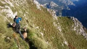
This is over 1000 meters. See the rope anchored to the rock wall and the handrail rope a bit out from it?
1564016606566.webp

Oh lookie! No guard ropes whatsoever but, a really gorgeous Goat to step over! lol
1564017203539.webp
 
Not wanting to use up your time with more questions when you are so close to leaving, but have you seen this track that parallels the N-621?

SENDA FLUVIAL de LA HERMIDA a URDÓN, paseo junto al Rio Deva, La Hermida(Cantabria)

It looks like for the section between Urdón and La Hermida, you can get off the highway (except for 50 meters) and be separated from the traffic, ... and it's rated "easy" - "safe for dogs and kids...easy for the whole family." Take a look at photo #24 for a schematic of the route, and see the comments re the ease of navigating. There are still sections with cables, but in the photos the path looks well graded and wide enough to be easy to walk.
 
Last edited:
A selection of Camino Jewellery
Not wanting to use up your time with more questions when you are so close to leaving, but have you seen this track that parallels the N-621?

SENDA FLUVIAL de LA HERMIDA a URDÓN, paseo junto al Rio Deva, La Hermida(Cantabria)

It looks like for the section between Urdón and La Hermida, you can get off the highway (except for 50 meters) and be separated from the traffic, ... and it's rated "easy" - "safe for dogs and kids...easy for the whole family." Take a look at photo #24 for a schematic of the route, and see the comments re the ease of navigating. There are still sections with cables, but in the photos the path looks well graded and wide enough to be easy to walk.
Islandwalker is right: there is this track parallel to the N-621. It only leaves you with the stretch from Rumenes (where you join the N-621) to Urdon, which is 1.6 km.
 
The 2024 Camino guides will be coming out little by little. Here is a collection of the ones that are out so far.

❓How to ask a question

How to post a new question on the Camino Forum.

Featured threads

❓How to ask a question

How to post a new question on the Camino Forum.

Featured threads

Forum Rules

Forum Rules

Camino Updates on YouTube

Camino Conversations

Most downloaded Resources

This site is run by Ivar at

in Santiago de Compostela.
This site participates in the Amazon Affiliate program, designed to provide a means for Ivar to earn fees by linking to Amazon
Official Camino Passport (Credential) | 2024 Camino Guides
Back
Back
Top