Search 74,075 Camino Questions

Valcarlos to Roncesvalles - what are the conditions like?

Gumba

Active Member
Time of past OR future Camino
Winter CF2018 Winter CF2019-20
Bought our tickets last week - OMG - it has become a reality!

As we (me, husband and our two children) will be starting mid March, we will be walking via Valcarlos. We will spend the night there and then make our way to Roncesvalles.

Can anyone share what the 'path' is like? I know it will be steep and I know there is some walking on the road - what I would like to know is how far/long will we be walking on the road and how safe will it be? ie is there a path next to the road or will it be single file along the road with lots of bends meaning you cant see too far ahead?

While my youngest tries to be safe and sensible he is just as likely to step on the road because there is a white splodge on the road, or a beetle or he might decide to have one foot on the road and one on the dirt.... You get what I mean...

Will I be able to walk holding his hand or walk side by side (when we are on/close to the road), or is it pretty much single file. Will we be able to see far enough ahead to hold on to him if there is a car/truck passing)

This is the only section I am concerned about (so let me know if there are others!!!!) I am actually thinking of taking him (and his older brother if he doesn't want to walk up the hill) by taxi to Ronsesvalles as I am so concerned.

Please let me know of your experiences and thoughts,

Thanks you.
 
Ideal sleeping bag liner whether we want to add a thermal plus to our bag, or if we want to use it alone to sleep in shelters or hostels. Thanks to its mummy shape, it adapts perfectly to our body.

€46,-
This is only my opinion and I only did it once, but I thought the part on the road was very dangerous. I hugged the edge of the road (no path) and was frightened at many curves. I don't know how many km it was. Seemed like forever to me and the road was very busy. I had walked the Napolean before and the contrast might have blighted my Valcarlos experience.
 
Holoholo automatically captures your footpaths, places, photos, and journals.
If you use Google Maps, you can take a virtual walk the entire distance. The road is not busy; just keep left and stay alert. The diversions off the road in March probably will be covered in snow, so plan on a road walk most of the way. There are many worse road walks in Spain! :)
 
Thanks for the reply, Falcon. I will use google maps as suggested (had not thought about that!) By 'many worse road walks in Spain' do you mean on the CF? If so can you give me some idea of where?

Thanks.
 
The Pilgrim Office in SJPdP will give you a schematic map showing both routes.
Within SJPdP both caminos follow the rue de La Citadelle which becomes the rue d' Espagne after crossing the river and then the rue de Saint-Michel which will start to climb. At the first y junction the marker for the Valcarlos route turns right to follow along the Chemin de Mayorga and the marker for the Napoleon goes left

Here is a copy of the map the SJPdP Pilgrim Office will give you. At the bottom right you can see photos of the road.

Do you have a reservation in Valcarlos ? The municipal albergue is great and you can reserve there. Nearby the Casa Marcelino has good food and also rooms.

The path diverges off the road into the woods; In bad weather, ie. snow, fog, rain, I always followed the road parallel to the path. The roads are fine but do walk on the left-side verges facing traffic. If you walk at dusk wear something bright and carry your light to flash towards on-coming traffic.

Between SJPdP and Valcarlos there is only one place for food/water/petrol near the old frontier; between Valcarlos and Roncesvalles there is no place for food nor water. Be prepared!
 
Last edited:
3rd Edition. More content, training & pack guides avoid common mistakes, bed bugs etc
Train for your next Camino on California's Santa Catalina Island March 16-19
Why don't you reduce the worry by starting in Roncesvalles? There is no particular virtue in starting in SJPP, especially if you are concerned about safety.
There are a number of taxis in SJPdP all charging about 50 euros to get to Roncevalles. This may be cheaper than changing any travel plans you may have already made.
 
There are a number of taxis in SJPdP all charging about 50 euros to get to Roncevalles. This may be cheaper than changing any travel plans you may have already made.
That much! The husband wants to start at SJPdP - we would like to at least walk to Valcarlos - can we get a taxi from there to Roncevalles?
 
Get a spanish phone number with Airalo. eSim, so no physical SIM card. Easy to use app to add more funds if needed.
Transport luggage-passengers.
From airports to SJPP
Luggage from SJPP to Roncevalles
I think there is a two hours walk from Valcarlos to the point where the Camino enters the wood -with a previous detour by a dirt path and the picturesque Gainekoleta village.
Almost no shoulder, so you have to walk mostly in the road proper. See a photo here
I felt uneasy, but not particularly worried. Traffic was scarce and drivers careful. I used to wave to them, both for politeness and as a way to tell them "hey, I am here".
About walking there with a little children...well, parents always know better. Maybe you can take a taxi from Valcarlos to the point where the Camino goes into the forest; I remember a place where cars could stop.
I walked this alternative in mid-March, and it was cold, with a light rain, perfectly doable. It had snowed heavily a couple of days before, but there were only traces left.
It was a solo walk, with nobody in sight -but this could have changed, since the Napoleon route is closed in March.
When I was arriving at Ibañeta chapel (that's the point where you can tell to yourself "ok, I made it"), there was a moment of sunshine, birds started to chirp and everything looked brighter. It was only some instants, but I felt as I was being welcomed. In general terms, this stage is one that I particularly liked, one of the best.
I recommend you stop at Valcarlos -a pleasant, kind Basque village.
Buen camino!
 
I like the Valcarlos route that I took this spring due to my left leg. I took off the 28th of April and the day before the Napoleonic route had been closed.
As I arrived into Roncevalles, it started to snow. So Do Not Gamble...
It is true that it would be prudent to divide into two etapes, especially as the latter leg before Roncevalles goes from 200 meters and after Gañecoleta again from 400 meters to a 1000 meters above sea level. I took my breath away, I must admit , in my sixties, and so it might for some children. Going up the last , steep bit, I ran out of water, never happened before in my life, so be prepared...
Directly after thwe top, it goes down 50 meters in height again, and there´s Roncevalles monastery.... Be sure to reserve room. the first, last and only place on the Camino itself I have made reservations..
It is true there are stretches by the road,- it is doable , but there are good stretches into the woods too, and there absolutely worth it !! Check Brierley´s for example..
Staff in San Jean Pied de Port office will give you a very detailed map over routes and absolutely insist on instructing the details...

Why miss this :
https://photos.app.goo.gl/uAejsj7dqTXmO2UJ3
https://photos.app.goo.gl/xyV4yFXSrWEhD2R22
 
Last edited:
Holoholo automatically captures your footpaths, places, photos, and journals.
I walked this route in early March 2015.
Before Valcarlos there was some road walking, but on small secondary roads and traffic was almost non-existent; I found it very pleasant. After Valcarlos, it was a bit busier, but the paths through the woods avoid a lot of road walking. I followed the map in Brierley and had no problem wayfinding; it was one of the most magical days of that Camino. (I did encounter snow at the top, and had to walk the road from Ibañeta down to Roncesvalles...but visibility was good.
 
Hi @Gumba ,

I walked both routes as a one day stretch but I walked Valcarlos route completely on the road due to injury. As already mentioned above no real or wide shoulders but very scarce traffic. Walking on the left facing the vehicles and wearing something reflective (I put a silver duct tape on my walking poles just below the handles, one meter in length because it's handy for other Camino related purposes too) I think it's enough. I would only be more cautious if the fog comes. In this conditions you really have to use your knowledge of a driver to predict the situation for on-coming driver.

If you are afraid your kids would do something automatically and therefore step too far into the lane maybe let one of them walk in front of you leading the way (and the second one before your husband), attach a short rope or a cord from his rucksack/waist to your backpack straps so you could pull him back if anything unwanted happen. Same as you would do serious mountaineering with kids on exposed rock paths.

Anyway it's better to be prepared than sorry. Buen Camino to all of you. It will be a wonderful experience walking with kids :)
 
Last edited:
I walked SJPP on the Valcarlos route in October last year and there was a lot of traffic and fast to boot. There is no path alongside the road when walking from Valcarlos to the woods pathway (the entrance to the path is well marked--a bench and fountain at the start, if I recall). You really have to hug the side of the road or even walk on the storm drain cover (I don't know what else to call them--slats of wood across the storm drain ditches on one side of the road). The left side going up sometimes only has the option of walking on the road; the other side of the barrier is lots of down, trees and rocks.

I would go back and forth, walking on both sides, always judging when there was traffic or no traffic; on the turns I'd walk on the right side on those drain covers...like a slat walkway, but not...)

If your husband really wants to walk from SJPP to Roncesvalles, and you and your children want to walk to Valcarlos, I would second the idea of taking a taxi to Roncesvalles instead of walking on the road. If you get there before your husband, there isn't a great deal to do but the architecture of the monestry and the churches is spectacular. If your children are quite young the yard (not quite a cloister) at Valcarlos is big and would be a great place to play.

The walk to Valcarlos is nice, pretty, is off busy roads and has an easy incline to get to the village. I would walk it again. The albergue in Valcarlos is wonderful as are the people and the views. And the walk from Valcarlos to Roncesvalles was tremendous, but I was fortunate to walk on a warm, sunny day.
 
Last edited:
3rd Edition. More content, training & pack guides avoid common mistakes, bed bugs etc
I think there is a two hours walk from Valcarlos to the point where the Camino enters the wood -with a previous detour by a dirt path and the picturesque Gainekoleta village.
Almost no shoulder, so you have to walk mostly in the road proper. See a photo here
I felt uneasy, but not particularly worried. Traffic was scarce and drivers careful. I used to wave to them, both for politeness and as a way to tell them "hey, I am here".
About walking there with a little children...well, parents always know better. Maybe you can take a taxi from Valcarlos to the point where the Camino goes into the forest; I remember a place where cars could stop.
I walked this alternative in mid-March, and it was cold, with a light rain, perfectly doable. It had snowed heavily a couple of days before, but there were only traces left.
It was a solo walk, with nobody in sight -but this could have changed, since the Napoleon route is closed in March.
When I was arriving at Ibañeta chapel (that's the point where you can tell to yourself "ok, I made it"), there was a moment of sunshine, birds started to chirp and everything looked brighter. It was only some instants, but I felt as I was being welcomed. In general terms, this stage is one that I particularly liked, one of the best.
I recommend you stop at Valcarlos -a pleasant, kind Basque village.
Buen camino!
Taxi from Valcarlos to where the camino goes into the forest is a very good suggestion.
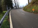
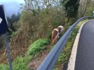
Here's some more pics. Not quite as dangerous as it looks because the steepness and number of bends means that traffic travels slower than usual. At many bends it is not possible for pilgrim, car going down and car going up to all pass at the same time. Only happened to me the once and the car going up gave way and waited for me to get around the bend. My contingency plan at one stage was to join the tiny little ponies on the other side of the guard rail. :p:p:p It's a lovely walk and once I got over the surprise about how little room there was on the edge of the road I got used to it quite quickly.

IMG_4548.webp IMG_4547.webp IMG_4536.webp
 
Actually, the Valcarlos albergue seemed to be in the same building of a kindergarten...:)
Yes, you are right, Felipe; right up at the top of the stairs!
 
Train for your next Camino on California's Santa Catalina Island March 16-19
Taxi from Valcarlos to where the camino goes into the forest is a very good suggestion.
Here's some more pics. Not quite as dangerous as it looks because the steepness and number of bends means that traffic travels slower than usual. At many bends it is not possible for pilgrim, car going down and car going up to all pass at the same time. Only happened to me the once and the car going up gave way and waited for me to get around the bend. My contingency plan at one stage was to join the tiny little ponies on the other side of the guard rail. :p:p:p It's a lovely walk and once I got over the surprise about how little room there was on the edge of the road I got used to it quite quickly.

View attachment 36281 View attachment 36282 View attachment 36283

I guess the traffic is heavier on Sundays-- people from France go to the border mall to eat and shop, where things are cheaper. The cars were not able to travel fast around those bends, true, but they still were travelling pretty fast. Buses, motorcycles, trucks, and bikes as well as cars were on the road. I wouldn't take any kid along that road, especially on that day! Yikes!!
 

❓How to ask a question

How to post a new question on the Camino Forum.

Most read last week in this forum

Ok so ... this past spring (2024) I decided to walk the "lower" route into Pamplona and became really lost. I just keep thinking about it and it really bugs me. Where did I go astray? At the...
Hi fellow wanderers, I would like a bit of input on this one please. I have finally decided to revisit the Camino Frances next year. I walked SJPDP to Santiago solo in 2016 and walked from...
I asked the tourist office for information about the statue of the pilgrim at the entrance to Carrión de los Condes. Here is their reply. auto-translated: "The Monument to the Pilgrims" is a...
I understand that footwear on the Camino is a personal choice. I will start my first Camino on the Camino Frances in the first part of April. With the varying weather conditions, what...
Hello. Earlier this year I saw photos of the streets being decorated for Corpus christi and I'm thinking that when I do my next camino, probably 2026, that it would be nice to help with the...
Hello, I am looking to continue a segment of the Camino Frances, that I started 10 years ago. I would be starting back up in Burgos. Is it possible to do this in January ? It seems like the...

Featured threads

❓How to ask a question

How to post a new question on the Camino Forum.

Featured threads

Forum Rules

Forum Rules

Camino Updates on YouTube

Camino Conversations

Most downloaded Resources

This site is run by Ivar at

in Santiago de Compostela.
This site participates in the Amazon Affiliate program, designed to provide a means for Ivar to earn fees by linking to Amazon
Official Camino Passport (Credential) | 2024 Camino Guides
Back
Back
Top