- Time of past OR future Camino
- Via Gebennensis (2018)
Via Podiensis (2018)
Voie Nive Bidassoa (2018)
Camino Del Norte (2018)
My darling and I are walking to SdC, and we started today from Lisbon. Until we get to Tomar, we're not following the traditional Caminho.
We'll be following the Trilho das Areias to Nazaré, with a detour when we get to Peniche, then crossing to Fatima and resuming the official Caminho from there.
I thought I would report on this alternative here - hopefully regularly .
.
Note: this is not an "official" Caminho, and there's a website with more information.
Also, we're distance challenged slow walkers
Day 1: Lisbon to Caxias, 15.2km
From the Sé de Lisboa, we walked down to the Praça do Comercio, and from there, we virtually stayed on the shores of the Tagus.
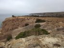
Much of the way follows cycle and pedestrian paths, with some "interesting" parts, and many scenic parts. It goes past the Padrão dos Descubrimentos and the Torre de Belém. Deserted at this time of the morning
At Caxias, we took the Comboios de Portugal train back to Cais do Sodré and Lisbon, 1.75€.
Flat all the way, and our distance includes a detour to eat Pastéis de Belém

We'll be following the Trilho das Areias to Nazaré, with a detour when we get to Peniche, then crossing to Fatima and resuming the official Caminho from there.
I thought I would report on this alternative here - hopefully regularly
.Note: this is not an "official" Caminho, and there's a website with more information.
Also, we're distance challenged slow walkers
Day 1: Lisbon to Caxias, 15.2km
From the Sé de Lisboa, we walked down to the Praça do Comercio, and from there, we virtually stayed on the shores of the Tagus.
Much of the way follows cycle and pedestrian paths, with some "interesting" parts, and many scenic parts. It goes past the Padrão dos Descubrimentos and the Torre de Belém. Deserted at this time of the morning
At Caxias, we took the Comboios de Portugal train back to Cais do Sodré and Lisbon, 1.75€.
Flat all the way, and our distance includes a detour to eat Pastéis de Belém