Search 74,075 Camino Questions

The Quirky Double Camino Pillars Between Tui and 5K Before O Porrino or When in Doubt always walk down hill :)

Andorinha

Active Member
Time of past OR future Camino
Tomar to Sant (2019) (2024) Tui to Sant (SV)
https://sound-and-bites.home.blog/
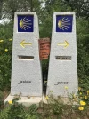
About 5K before O Porrino on the Portuguese Camino you will come across two official camino pillars. One points left to a path that leads slightly downhill, and another leads straight slightly uphill which appears to be a town. You will approach it and just try and figure out which way to go.

Here are your two fates. If you take a left and walk slightly downhill you will enter the forest and a river path that you can follow - it will be in the same spirit as the beautiful paths with roman bridges that you followed earlier in the day. If you walk straight and slightly uphill thinking that option will lead to more nature, you are wrong apparently! I was informed at my albergue-mate that evening, that that way leads into town and to a 5K "concrete and road walking in an industrial area" trek -- and he did not seem happy about it. If you need provisions, then you might go into town and then backtrack to the trail that leads into the forest and river.
I think these double official camino markers are there due to the tensions that can arise between town and camino path makers - I am sure bypassing camino walkers off the town path is not supporting their businesses and they found a way to perhaps compromise and create official pillars with two arrows. I am not sure why he choose that path, but maybe he was not using a guidebook or maybe he just needed some coffee and walked that way not knowing how industrial his path would become. The book I was using, the village to village by Landis, Harms and Dintaman guide did have a little information that there were two paths that they noted on their elevation map, but I did not see anything in that book clearly explaining the consequences.

I must make a short statement about the various guide books. The orange one many European camino walkers used was followed very strictly from my observations - even to the extent of pushing stages past many people's comfort levels. For example, at the end of my camino in Santiago at dinner with some lovely women from Germany, they noted that their orange book was borrowed from a friend and that on the page with instructions for walking from Porto to Vila do Condo there was a sad frowny face next to that stage. They said after they walked that long stage they felt they understood that emoji exactly.

When I met the author of the orange book at the campground in LaBruge (as I talk about in my blog) he seemed really interested in my village to village book and asked to see it. He immediately remarked about how lightweight it was and he seemed impressed by that, but I was not able to engage with him much about his own book, and frankly the women who I walked into the late dark night with along the beach that previous night was in fact late because she followed his book exactly, even the extent of eating a fish he recommended along the way (she did say it was a very delicious fish) and many people find the orange book their perfect companion - it is only currently printed in the German language.

My village to village book I can recommend for anyone who wants just the minimal path information, some elevations maps, and some recommendations for places to stay. I did think to myself a few times that maybe the guides of my book had not walked a section, or just had space issues in their short book. For example, at the start of one day the map clearly points out more risky road crossings and narrow paths, but later in the day there were even more and worse issues to contend with with no mention of those at all. I am 80% sure I was just tired and grumpy, but I was also pretty sure there were earlier mentions and not later in the day mentons for safety lookouts. Once, I was walking with E. early on in Portugal and she noticed her book (I am not sure which book she has used) had some places to stay that in fact were closed down already for a full year. Therefore, the forum list of current albergues is much more useful in my mind that a printed book, but mine did work for a night to stay most nights. But, I just "followed the arrows" and always ended up where I ended up - and that worked fine for me.
 
Last edited:
The 2024 Camino guides will be coming out little by little. Here is a collection of the ones that are out so far.
Hi,
I heard about the O Porriño industrial area at least 10years before I started my own Caminho Portugues and it was repeatingly mentioned at least once per year, since the markers have often disappeared in these years, sometimes had been painted black then yellow, the wooden markers were destroyed etc.
In my opion that talk is highly overrated. It's more like a little challenge which can be compared to the Burgos industrial area. You don't need to pass it, but if you don't watch out sometimes you can miss the detour.

As a German I'm used to yellow and red guide books. Apart from that I saw green and blue, but so far nobody was talking about an orange one.
If you spoke to Raimund Joos you mean the "yellow" guide. Unfortunately it was getting fat and fatter during the years and that's not only because of more places to stay. The albergue to albergue system probably compares to your own and is in my opionion the most practical for long distance walks. To be honest I thought the CPor guide was translated some years ago into english. Maybe they did it only for the CF.

I found a Rother Norte guide (red) which I took on the way. Can't be recommend, since it does not name possible detours to the beaches, so the Norte is basically road walking a few km from the sea. I was aware of the fixed day tours, which means once your are off this raster you have to carefully search where you are plus you need to find the amenties of the village in different parts of the day chapter. Some info you'll find in the text, some like albergues and restaurants in the beginning of the chapter, but still fragmented in that section.
At least for me not worth to carry.

Most other ways I had a sheet of paper with the villages, distances and amenities and some additional documents on the cellphone (e.g. from gronze.com, just in case I want to read a bit more). A GPS (app) with a good map can be handy. Not only if you got lost or if you search for the nearest food or place to stay. You often believe you did so much and the realitycheck tells you it was only half of the expected.

PS: found a preview for the village to village guide. very compressed info, nice maps, but 25US$ is far too expensive
 
https://sound-and-bites.home.blog/
About 5K before O Porrino on the Portuguese Camino you will come across two official camino pillars. One points left to a path that leads slightly downhill, and another leads straight slightly uphill which appears to be a town. You will approach it and just try and figure out which way to go.

Here are your two fates. If you take a left and walk slightly downhill you will enter the forest and a river path that you can follow - it will be in the same spirit as the beautiful paths with roman bridges that you followed earlier in the day. If you walk straight and slightly uphill thinking that option will lead to more nature, you are wrong apparently! I was informed at my albergue-mate that evening, that that way leads into town and to a 5K "concrete and road walking in an industrial area" trek -- and he did not seem happy about it. If you need provisions, then you might go into town and then backtrack to the trail that leads into the forest and river.
I think these double official camino markers are there due to the tensions that can arise between town and camino path makers - I am sure bypassing camino walkers off the town path is not supporting their businesses and they found a way to perhaps compromise and create official pillars with two arrows. I am not sure why he choose that path, but maybe he was not using a guidebook or maybe he just needed some coffee and walked that way not knowing how industrial his path would become. The book I was using, the village to village by Landis, Harms and Dintaman guide did have a little information that there were two paths that they noted on their elevation map, but I did not see anything in that book clearly explaining the consequences.

I must make a short statement about the various guide books. The orange one many European camino walkers used was followed very strictly from my observations - even to the extent of pushing stages past many people's comfort levels. For example, at the end of my camino in Santiago at dinner with some lovely women from Germany, they noted that their orange book was borrowed from a friend and that on the page with instructions for walking from Porto to Vila do Condo there was a sad frowny face next to that stage. They said after they walked that long stage they felt they understood that emoji exactly.

When I met the author of the orange book at the campground in LaBruge (as I talk about in my blog) he seemed really interested in my village to village book and asked to see it. He immediately remarked about how lightweight it was and he seemed impressed by that, but I was not able to engage with him much about his own book, and frankly the women who I walked into the late dark night with along the beach that previous night was in fact late because she followed his book exactly, even the extent of eating a fish he recommended along the way (she did say it was a very delicious fish) and many people find the orange book their perfect companion - it is only currently printed in the German language.

My village to village book I can recommend for anyone who wants just the minimal path information, some elevations maps, and some recommendations for places to stay. I did think to myself a few times that maybe the guides of my book had not walked a section, or just had space issues in their short book. For example, at the start of one day the map clearly points out more risky road crossings and narrow paths, but later in the day there were even more and worse issues to contend with with no mention of those at all. I am 80% sure I was just tired and grumpy, but I was also pretty sure there were earlier mentions and not later in the day mentons for safety lookouts. Once, I was walking with E. early on in Portugal and she noticed her book (I am not sure which book she has used) had some places to stay that in fact were closed down already for a full year. Therefore, the forum list of current albergues is much more useful in my mind that a printed book, but mine did work for a night to stay most nights. But, I just "followed the arrows" and always ended up where I ended up - and that worked fine for me.
I was told that two parties that owned bars in the town had been quarreling about the Camino route and that one thought it was bypassing his business, so he made the split to bring Pilgrims into town sooner. The left route is a shaded walk along the river and does come into the center of the town.
 
€2,-/day will present your project to thousands of visitors each day. All interested in the Camino de Santiago.
I must have missed the confusion. Nearly everyone I met took the “Complimentary” route because they intended to do so. If not, there is usually someone recruiting pilgrims from an albergue who is happy to advise. :p
 
I was told that two parties that owned bars in the town had been quarreling about the Camino route and that one thought it was bypassing his business, so he made the split to bring Pilgrims into town sooner. The left route is a shaded walk along the river and does come into the center of the town.
i was just surprised that there were two pillars exactly the same pointing opposite directions - stone expensive pillars side by side. I cannot find my image of them, but one said complimentary and I do not recall what the other one said, maybe someone has an image? The man I was at the albergue that night seemed to just flip a coin and got on the industrial path. I do not recall getting to the center of town, but you do eventually seem to get to a roadway and some neighborhoods - maybe that was town, I am not sure.
 
Hi,
I heard about the O Porriño industrial area at least 10years before I started my own Caminho Portugues and it was repeatingly mentioned at least once per year, since the markers have often disappeared in these years, sometimes had been painted black then yellow, the wooden markers were destroyed etc.
In my opion that talk is highly overrated. It's more like a little challenge which can be compared to the Burgos industrial area. You don't need to pass it, but if you don't watch out sometimes you can miss the detour.

As a German I'm used to yellow and red guide books. Apart from that I saw green and blue, but so far nobody was talking about an orange one.
If you spoke to Raimund Joos you mean the "yellow" guide. Unfortunately it was getting fat and fatter during the years and that's not only because of more places to stay. The albergue to albergue system probably compares to your own and is in my opionion the most practical for long distance walks. To be honest I thought the CPor guide was translated some years ago into english. Maybe they did it only for the CF.

I found a Rother Norte guide (red) which I took on the way. Can't be recommend, since it does not name possible detours to the beaches, so the Norte is basically road walking a few km from the sea. I was aware of the fixed day tours, which means once your are off this raster you have to carefully search where you are plus you need to find the amenties of the village in different parts of the day chapter. Some info you'll find in the text, some like albergues and restaurants in the beginning of the chapter, but still fragmented in that section.
At least for me not worth to carry.

Most other ways I had a sheet of paper with the villages, distances and amenities and some additional documents on the cellphone (e.g. from gronze.com, just in case I want to read a bit more). A GPS (app) with a good map can be handy. Not only if you got lost or if you search for the nearest food or place to stay. You often believe you did so much and the realitycheck tells you it was only half of the expected.

PS: found a preview for the village to village guide. very compressed info, nice maps, but 25US$ is far too expensive
Yes, that is the author, it just kind of looks orange to me? anyhow, he was nice and told me his book -- he must have meant portuguese camino was only in German. He was scouting out his bicycle version and re-checking mileage. He seemed like a very nice guy. The village to village book is expensive, yes, considering!
58257
 
3rd Edition. More content, training & pack guides avoid common mistakes, bed bugs etc
Yes, that is the author, it just kind of looks orange to me? anyhow, he was nice and told me his book -- he must have meant portuguese camino was only in German. He was scouting out his bicycle version and re-checking mileage. He seemed like a very nice guy. The village to village book is expensive, yes, considering!
View attachment 58257
As an artist, I call this book orange; not yellow. Carry on. Jill
 
Recently, as we were nearing O'Porrino we met a girl dressed in "Camino gear " with a Camino Portuguese, blue tee shirt. She offered advice about which path to take, we'd already read about the options (Brierley guide) . Her advice was correct and we took the river route. Very pleasant. We saw another person wearing the same gear / uniform at the first hostel. Are these people employed by the tourist office??
 
i was just surprised that there were two pillars exactly the same pointing opposite directions - stone expensive pillars side by side. I cannot find my image of them, but one said complimentary and I do not recall what the other one said, maybe someone has an image?
It’s camino principal and camino complementario. You find these new double pillars elsewhere on the Camino Francés in Galicia, too. One is the traditional way - however that is defined - and the other one is an option that is either nicer to walk, passes by a monument of interest or services or similar.
 
Last edited:
Join the Camino cleanup. Logroño to Burgos May 2025 & Astorga to OCebreiro in June
As an artist, I call this book orange; not yellow. Carry on. Jill
Recently, as we were nearing O'Porrino we met a girl dressed in "Camino gear " with a Camino Portuguese, blue tee shirt. She offered advice about which path to take, we'd already read about the options (Brierley guide) . Her advice was correct and we took the river route. Very pleasant. We saw another person wearing the same gear / uniform at the first hostel. Are these people employed by the tourist office??
that is so interesting - I walked through there just over a month ago and it was just the pillars :) but that sounds interesting, and would not the town folks feel disgruntled?
 
It’s camino principal and camino complementario. You find these new double pillars elsewhere on the Camino Francés in Galicia, too. One is the traditional way - however that is defined - and the other one is an option that is either nicer to walk, passes by a monument of interest or services or similar.
yes, I saw other options, but not side by side like this one - but this is helpful!!
 
Get a spanish phone number with Airalo. eSim, so no physical SIM card. Easy to use app to add more funds if needed.
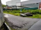
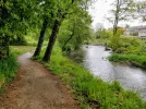
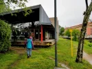
Wow, I am totally confused. I write an eBook on the route, update it whenever I can and this is my photo of where I believe you are talking about. (See 1st photo or consult my day twenty on the CP) I was not using anyone's guide, but maps/Wikiloc tracks only. When we passed under the underpass of the A-55, we couldn't find any waymarks, no double pillars that I saw. We asked a local and he pointed to the left, to take the lovely river walk that you are describing, that I measured at 2 km, not 5 km. I was with a group of folks, and it was raining, which could have obscured our view, but NONE of us saw the double pillar which you are describing. The yellow arrows on blue signs, indeed looked homemade, but I did trust the local knew what he was talking about. The riverwalk came out at the Albergue de Peregrinos de O Porriño. If someone wants to elucidate me, I would appreciate it, so I can update my information in my guide. I will give you a free guide of your choice for your efforts!

Here's the left turn onto the riverwalk:

58273

Here's the riverwalk itself:

58276

Here's the albergue where it ends in the center of town.

58275
 
wow I am totally confused... this is where I believe you are talking about.

I have not walked this route but plan to this fall thus I have taken an interest in this post. I have a Wise Pilgrim guide and The Brierley Guide. Using this info and what the OP has already written, I believe you are talking about the "left turn" 2 km before Porrino IMMEDIATELY after passing under the A-55 highway bridge (I think your picture shows the concrete bridge support/foundation on the very left side of your picture. The double obelisk camino markers the OP is talking about are 6.5 km back in Orbenlle. The Wise Pilgrim says walk thru Orbenlle and the double obelisks are at the end of town (edit: after doing some additional research that is in my next post, this tip from Wise Pilgrim does not seem to be useful to me because "end of town" is very subjective). Brierley says the only reliable way mark for this turn is the big Mural called "Portico do Gloria" and it is .2 km before the turn into the woods.
 
Last edited:
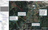
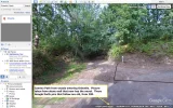
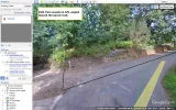
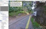
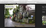
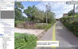
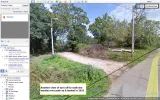
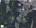
I went to google earth to check out this area of Orbenlle for any more clues. I did find street views but the images are from 2011. I took pics from google earth showing the path from the woods as it comes into the town of Orbenlle and the stone wall in front of you as you exit the woods. Back in 2011 there was no mural on that stone wall per google earth image but there is a mural there now as evidenced by another picture I posted that I found on the web. You can see from the stone work it is the same spot. I also show screen shots from google earth of the turn off the main trail (blue) to take the woods/river route (red). This "red" and "blue" route are from a .kmz file I found on the web last year that overlays ALL of the Camino routes into Google Earth. They are actually "gray" and "black" respectively when viewing but that did not stand out well enough to illustrate the routes so added the blue color. When hovering over the "gray" woods/river route, it turns red and that is when I did my screen shot. The other "street view" images from google earth are 8 years old and there are NO stone obelisks at the intersection of red and blue routes. But I believe the OP is referring to this red/blue intersection as the place the double obelisks are standing today. The overhead view from Google Earth is from 2018 and clearly shows the scale and relative distance for the turns. If you walk past the bar, then you know you went to far, grab a quick beer and then turn around.

one top view.pngone trail from woods.pngtwo pan right from trail.pngthree pan more to wall with mural.pngfour recent mural on wall.pngfive left turn off main route into woods.pngsix turn into woods.png
 
Last edited:
The 2024 Camino guides will be coming out little by little. Here is a collection of the ones that are out so far.
Wow, I am totally confused. I write an eBook on the route, update it whenever I can and this is my photo of where I believe you are talking about. (See 1st photo or consult my day twenty on the CP) I was not using anyone's guide, but maps/Wikiloc tracks only. When we passed under the underpass of the A-55, we couldn't find any waymarks, no double pillars that I saw. We asked a local and he pointed to the left, to take the lovely river walk that you are describing, that I measured at 2 km, not 5 km. I was with a group of folks, and it was raining, which could have obscured our view, but NONE of us saw the double pillar which you are describing. The yellow arrows on blue signs, indeed looked homemade, but I did trust the local knew what he was talking about. The riverwalk came out at the Albergue de Peregrinos de O Porriño. If someone wants to elucidate me, I would appreciate it, so I can update my information in my guide. I will give you a free guide of your choice for your efforts!

Here's the left turn onto the riverwalk:

View attachment 58273

Here's the riverwalk itself:

View attachment 58276

Here's the albergue where it ends in the center of town.

View attachment 58275
Hello! I am a fan of yours !! :)) It is the ONE, I swear, photo I did not take and I knew I would regret it lol! It
Wow, I am totally confused. I write an eBook on the route, update it whenever I can and this is my photo of where I believe you are talking about. (See 1st photo or consult my day twenty on the CP) I was not using anyone's guide, but maps/Wikiloc tracks only. When we passed under the underpass of the A-55, we couldn't find any waymarks, no double pillars that I saw. We asked a local and he pointed to the left, to take the lovely river walk that you are describing, that I measured at 2 km, not 5 km. I was with a group of folks, and it was raining, which could have obscured our view, but NONE of us saw the double pillar which you are describing. The yellow arrows on blue signs, indeed looked homemade, but I did trust the local knew what he was talking about. The riverwalk came out at the Albergue de Peregrinos de O Porriño. If someone wants to elucidate me, I would appreciate it, so I can update my information in my guide. I will give you a free guide of your choice for your efforts!

Here's the left turn onto the riverwalk:

View attachment 58273

Here's the riverwalk itself:

View attachment 58276

Here's the albergue where it ends in the center of town.

View attachment 58275
Hello, I am a big fan of your's!! And your work is extremely helpful - so thank you! I recall the mural wall and then I walked and came to the "twin pillars" - if you turned left it was forested and river, straight was town looking - I am lazy and went left downhill. It is the ONE picture I did not take, figures! But, I can ask around and see if someone did. My walk ended in town and I stayed at a private albergue that night, not the one in your picture - but I did not end up there, but rather in town. thank you for your work and inspiration!
 
Thank-you for all you work @twh, and for including my mural photo. You are right, the photos I posted are just by the overpass of the A-55 and the final 2 km.

Just one year ago, unless we ALL missed this "red woods/river" turn as you describe it, after the mural, there was no waymark or arrow here! We all kept on straight on the road to "Os Eidos." If you read my article, I called going to the "Bar Laguna" a conspiracy" diversion in the Camino, as you look at my map, it was a nice loop diversion. However, because it was raining and we had 10 km under our belts we were grateful for the stop. There was no double waymark by the bar, that what would have led on to the industrial area, that you can clearly see in Google Earth. Unless, of course we missed it.

I understand exactly, @twh what you have portrayed in your responses, but unfortunately, I still haven't heard where the double waymark is?? At the "red woods/river" turn? At the mural? You can see the solitary waymark on my mural photo, clearly marking only a left hand turn!

Here is a screen shot of the "loop" we did, but managed to get back on the main, cultural route, as you can see in my article.

58311

@TheSparrow what I can tell by your description, is that this "Red wood/river" turn that @twh describes, would be where the double waymark now is. I can see where the shortcut turn would be on the screenshot I have here! I would appreciate if you, Sparrow, would indeed follow up with your friends! And @twh, if you walk, check it out for me to confirm. I will private message you both to follow up on sending you any of my eBooks, complimentary!

If, Sparrow, the double waymarks are brand-new, then maybe they weren't even there when we walked one year ago! Perhaps because of the the ongoing route disputes, they were taken down. Sure glad we didn't end up on the industrial road, because the forest ant the bridges on the cultural route were so lovely as my day twenty shows!

I will private message you both, (Sparrow and TWH) to arrange for your complimentary copy of any of my eBooks! Thank-you again.

And thank you, Sparrow, for you nice feedback. It is greatly appreciated. 😍
Most warmly, Elle
 
Thank-you for all you work @twh, and for including my mural photo. You are right, the photos I posted are just by the overpass of the A-55 and the final 2 km.

Just one year ago, unless we ALL missed this "red woods/river" turn as you describe it, after the mural, there was no waymark or arrow here! We all kept on straight on the road to "Os Eidos." If you read my article, I called going to the "Bar Laguna" a conspiracy" diversion in the Camino, as you look at my map, it was a nice loop diversion. However, because it was raining and we had 10 km under our belts we were grateful for the stop. There was no double waymark by the bar, that what would have led on to the industrial area, that you can clearly see in Google Earth. Unless, of course we missed it.

I understand exactly, @twh what you have portrayed in your responses, but unfortunately, I still haven't heard where the double waymark is?? At the "red woods/river" turn? At the mural? You can see the solitary waymark on my mural photo, clearly marking only a left hand turn!

Here is a screen shot of the "loop" we did, but managed to get back on the main, cultural route, as you can see in my article.

View attachment 58311

@TheSparrow what I can tell by your description, is that this "Red wood/river" turn that @twh describes, would be where the double waymark now is. I can see where the shortcut turn would be on the screenshot I have here! I would appreciate if you, Sparrow, would indeed follow up with your friends! And @twh, if you walk, check it out for me to confirm. I will private message you both to follow up on sending you any of my eBooks, complimentary!

If, Sparrow, the double waymarks are brand-new, then maybe they weren't even there when we walked one year ago! Perhaps because of the the ongoing route disputes, they were taken down. Sure glad we didn't end up on the industrial road, because the forest ant the bridges on the cultural route were so lovely as my day twenty shows!

I will private message you both, (Sparrow and TWH) to arrange for your complimentary copy of any of my eBooks! Thank-you again.

And thank you, Sparrow, for you nice feedback. It is greatly appreciated. 😍
Most warmly, Elle
You are entirely welcome! They in fact might have been brand new - it was an interesting moment on the Camino haha! Thank you again for all of your assistance in the camino world!
 
€2,-/day will present your project to thousands of visitors each day. All interested in the Camino de Santiago.
Elle, I looked around the web for more pictures of this turn off and the new double markers but could not find anything else more recent than 2017. The two photos below taken in 2017 confirm (in my opinion) that the turn is the same one, in the same place as the 2011 screen shots I took from Google Earth.

Also, I edited my earlier post to mention the "red" route on that top view from Google Earth is not something I drew in myself. It is from a .kmz file I found on the web that can be overplayed on to Google Earth that shows ALL of the Camino routes. See old post for a few more details on this.

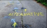
Photo 1 below shows a view of the turn with a marker on the left and lots of spray paint encouraging you NOT to turn off the asphalt road.

Photo 2 does the same on the road surface in front of the turn.

1 turn to River path 2017.png2 attempts to mislead.png
 
Last edited:
Join the Camino cleanup. Logroño to Burgos May 2025 & Astorga to OCebreiro in June
The 2024 Camino guides will be coming out little by little. Here is a collection of the ones that are out so far.
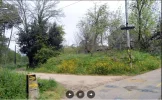
@john Gilliand do you know where this is, according to the above posts? @TheSparrow does this look like the one?
Bingo Elle!!! 100 percent sure - double pillars side by side. No fault of your own BTW if they are on your website, I just memorize your pictures and then follow arrows :)) and I had the best time ever!!
 
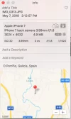
Not sure if this helps but this is the iPhone photo information:View attachment 58364
John, this iPhone photo info, nails it! It is totally where everyone is saying it is! I greatly appreciate your photo and this info. It is @twh 's "red" route on the map above. @John Gilliland may I use your photo in my eBook? I am happy to give you a complimentary eBook as well, and will give you credit in the book itself. Thank-you so very much again. @TheSparrow, thank you for confirming that this is indeed the waymarks you saw. To me, as I look at John's photo, they do look brand new!
 
The one from Galicia (the round) and the one from Castilla & Leon. Individually numbered and made by the same people that make the ones you see on your walk.
John, this iPhone photo info, nails it! It is totally where everyone is saying it is! I greatly appreciate your photo and this info. It is @twh 's "red" route on the map above. @John Gilliland may I use your photo in my eBook? I am happy to give you a complimentary eBook as well, and will give you credit in the book itself. Thank-you so very much again. @TheSparrow, thank you for confirming that this is indeed the waymarks you saw. To me, as I look at John's photo, they do look brand new!
Feel free to use it. No credit is needed. You and this Forum have already helped me tremendously.
 
Last edited:
John, I truly thank you! I am happy to send you a complimentary copy of any of my ebooks if you message me with your email. And I love to give my helpers credit!
 
I don't like the "complementario" information tag, because it does not give any advice, but at least we can hope these stone markers will not be stolen or moved just because of someones bar whos owner likes you to pass by.

back to "orange" ;). Maybe the color of my own books faded, but it is not as orange as the fruit. It's yellow like a Mango (inside) or a good amount of "yellow" arrows, including Ivars icon at the bottom. Yellow but still with some red shine. It has nothing to do with the lemon fruit yellow. Would you agree to use "gold"? I found it here. To say the truth I don't even know all colour words in my own language.
Is there a special name for the very pale yellow that we see on the double markerstone foto?
 
Perfect memento/gift in a presentation box. Engraving available, 25 character max.
I don't like the "complementario" information tag, because it does not give any advice, but at least we can hope these stone markers will not be stolen or moved just because of someones bar whos owner likes you to pass by.

back to "orange" ;). Maybe the color of my own books faded, but it is not as orange as the fruit. It's yellow like a Mango (inside) or a good amount of "yellow" arrows, including Ivars icon at the bottom. Yellow but still with some red shine. It has nothing to do with the lemon fruit yellow. Would you agree to use "gold"? I found it here. To say the truth I don't even know all colour words in my own language.
Is there a special name for the very pale yellow that we see on the double markerstone foto?
lol, agree to agree about colors - but I will call it the orange book :))
Also, I agree that the word "complementario" is useless to hapless travelers like myself - but since it pointed to a path downhill, I knew it was better lol
 
we can hope these stone markers will not be stolen or moved just because of someones bar whos owner likes you to pass by.

Agreed, instead of painting lemon colored arrows with the intent to confuse they should get their kids to open a lemonade stand at this junction.
 
I too have been waiting for someone to post that photo..one I also regretted not taking myself.. I remember clearly coming upon these Oct2018 and was confused because the board with map, some distance away from the markers, laid out 4 different routes, not two, and it referred to them with diff names / references...one was 'historico' if I recall. then my book gave yet a third version. For me an example of good intention but poor execution. we picked what we hoped was shortest...and we made it fine.. thankful to see and now able to download that quirky photo..the one that almost got away.
 
The focus is on reducing the risk of failure through being well prepared. 2nd ed.

❓How to ask a question

How to post a new question on the Camino Forum.

Featured threads

❓How to ask a question

How to post a new question on the Camino Forum.

Featured threads

Forum Rules

Forum Rules

Camino Updates on YouTube

Camino Conversations

Most downloaded Resources

This site is run by Ivar at

in Santiago de Compostela.
This site participates in the Amazon Affiliate program, designed to provide a means for Ivar to earn fees by linking to Amazon
Official Camino Passport (Credential) | 2024 Camino Guides
Back
Back
Top