Search 74,075 Camino Questions

The new official last part of the Camino del Norte

notion900

Veteran Member
Time of past OR future Camino
>
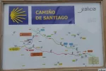
Last year I posted a resource on an alternative route to stay off the Camino Frances a bit longer from the Camino del Norte, and join it at St Irene instead of Arzúa. The Xunta de Galicia have now made an official alternative, which joins the Camino Frances at Lavacolla (ie nearly in Santiago). I have not walked this new route, but I thought I would post the new map of it which has appeared where the routes diverge at the end of Boimorto village, by the basketball court.

I have made a resource on this new official alternative.
20180813_164135.webp
 
Last edited:
3rd Edition. More content, training & pack guides avoid common mistakes, bed bugs etc
I walked it last year. Just what I was waiting for. Very calm, you're walking through the woods and join the French Road (Highway to be more precise) at the point of the airport. It you stay in Boimorto, it's a wonderful option for the last day(s). When this loud river from the French Way joined, I felt happy of any meter of silence I gained with this new option.
 
The 2024 Camino guides will be coming out little by little. Here is a collection of the ones that are out so far.
Last year I posted a resource on an alternative route to stay off the Camino Frances a bit longer from the Camino del Norte, and join it at St Irene instead of Arzúa. The Xunta de Galicia have now made an official alternative, which joins the Camino Frances at Lavacolla (ie nearly in Santiago). I have not walked this new route, but I thought I would post the new map of it which has appeared where the routes diverge at the end of Boimorto village, by the basketball court.

View attachment 46957

For those who like me are cartographically challenged, it took a while to realize that this map flips the east and west directions. This is not the first Spanish map to mess me up like this! So, if you haven't figured this out by now, left to right on that map above is east to west.

If I am reading this right, it is 28 from Boimorto to Lavacolla. And I think I calculated that Sobrado is about 11 from Boimorto. So this would make it an extremely short day from Sobrado. Other options, based on my very rough and maybe totally inaccurate calculations, would be from Roxica to Boimorto about 25, or from Miraz to Boimorto, about 37. You would have to give up the night in Sobrado, but it is great that there are now a lot of options!
 
Ijust a FYI I stayed in the albergue in Lavacola across from the supermarket in May.. I wonder if the path is before of after this. The albergue is located beyond the square with the few restaurants up the small hill behind the church on the Main Street. Next to the bus stop opposite side of the street infront of the market . I agree with @peregrina2000 on the maps I came across the same thing messed me up until I realized it was the opposite direction lol
 
Last edited:
...and ship it to Santiago for storage. You pick it up once in Santiago. Service offered by Casa Ivar (we use DHL for transportation).
Last year I posted a resource on an alternative route to stay off the Camino Frances a bit longer from the Camino del Norte, and join it at St Irene instead of Arzúa. The Xunta de Galicia have now made an official alternative, which joins the Camino Frances at Lavacolla (ie nearly in Santiago). I have not walked this new route, but I thought I would post the new map of it which has appeared where the routes diverge at the end of Boimorto village, by the basketball court.

View attachment 46957
I was planning my September 2019 route I was going to do Sobrado Boimorte Arzua Santa Irene. Santiago where is that part on your map the green line or the red line ? and where is the black line coming from? thanks
 
I was planning my September 2019 route I was going to do Sobrado Boimorte Arzua Santa Irene. Santiago where is that part on your map the green line or the red line ? and where is the black line coming from? thanks
Boimorto to St Irene is the black and green, the new route is the red.
 
Thank’s for this, I’m on Norte and appreciate all the information.
 
Join the Camino cleanup. Logroño to Burgos May 2025 & Astorga to OCebreiro in June
I was planning my September 2019 route I was going to do Sobrado Boimorte Arzua Santa Irene. Santiago where is that part on your map the green line or the red line ? and where is the black line coming from? thanks
thanks :)
 
If I am reading this right, it is 28 from Boimorto to Lavacolla. And I think I calculated that Sobrado is about 11 from Boimorto. So this would make it an extremely short day from Sobrado. Other options, based on my very rough and maybe totally inaccurate calculations, would be from Roxica to Boimorto about 25, or from Miraz to Boimorto, about 37. You would have to give up the night in Sobrado, but it is great that there are now a lot of options!

It's 13km from Sobrado to the place where the routes divide in Boimorto.
I will add your suggested stages to the resource.
 
Last edited:
Boimorto to St Irene is the black and green, the new route is the red.

so the red route doesnt go through Santa Irene then - where does it go through and is there an Albergue I was gonna do the last bit from Arzua to Amenal and then to Santiago (see I cant even remember my own route) So where would the red route stop me equivalent to Amenal on the green side??
 
€2,-/day will present your project to thousands of visitors each day. All interested in the Camino de Santiago.
so the red route doesnt go through Santa Irene then - where does it go through and is there an Albergue I was gonna do the last bit from Arzua to Amenal and then to Santiago (see I cant even remember my own route) So where would the red route stop me equivalent to Amenal on the green side??


no no scrap that I changed the end so many times no I decided to try bomorte to aruza then sante Irene then to santiago but I forgot to change the route on my plan page -- senior moments all of them ;)
 
no no scrap that I changed the end so many times no I decided to try bomorte to aruza then sante Irene then to santiago but I forgot to change the route on my plan page -- senior moments all of them ;)

but whatever route is better I will do that ....
 
The new route misses out Arzua, Pedrouzo, St Irene and takes you straight to Lavacolla, where there is an albergue and some hotels. The albergue has good reviews and takes reservations: www.alberguelavacolla.com From Lavacolla it's only 10km to Santiago, so it's easier to get there in time for 12.00 mass. The new route will be a lot quieter than the old, so it depends if you like company or not, and how much pressure there is on the albergues at the moment.
 
The one from Galicia (the round) and the one from Castilla & Leon. Individually numbered and made by the same people that make the ones you see on your walk.
And if you want to get even closer, the Casa Amancio is only about 7 or 8 from Santiago. I have stayed there and it was very nice, but it was years ago. It is now under new management -- the original family whose family home it was (I got to see where grandma was born on the floor of the old dairy barn) has sold out and two young guys are now running the place. Not the same vibe, very business-like, but the little apartments they rent out would be a decent price for a group. It is in a very nice setting and leaves you with very little ascent for the last hurrah into Santiago.

https://www.gronze.com/galicia/coruna/vilamaior/apartamentos-casa-amancio
 
For those who like me are cartographically challenged, it took a while to realize that this map flips the east and west directions. This is not the first Spanish map to mess me up like this! So, if you haven't figured this out by now, left to right on that map above is east to west.

If I am reading this right, it is 28 from Boimorto to Lavacolla. And I think I calculated that Sobrado is about 11 from Boimorto. So this would make it an extremely short day from Sobrado. Other options, based on my very rough and maybe totally accurate calculations, would be from Roxica to Boimorto about 25, or from Miraz to Boimorto, about 37. You would have to give up the night in Sobrado, but it is great that there are now a lot of options!

Hola Laurie - its OK to have senior moments!!. I could get interested in this Camino, The peace & quiet would attract!!
 
The new route misses out Arzua, Pedrouzo, St Irene and takes you straight to Lavacolla, where there is an albergue and some hotels. The albergue has good reviews and takes reservations: www.alberguelavacolla.com From Lavacolla it's only 10km to Santiago, so it's easier to get there in time for 12.00 mass. The new route will be a lot quieter than the old, so it depends if you like company or not, and how much pressure there is on the albergues at the moment.
HOw far is it from Boimorte to Lavacolla? I cant do more that 23kms in one stretch ( lots of reasons) is there somewhere to stop in the middle I couldnt find anything that would be much less O Pino is a detour as are the others which would make no logical sense and miss out the new route ... thanks I like company but I walk too slow for most people and they cant keep down with me ( as opposed to cant keep up with me ;) )
 
Perfect memento/gift in a presentation box. Engraving available, 25 character max.
The new route misses out Arzua, Pedrouzo, St Irene and takes you straight to Lavacolla, where there is an albergue and some hotels. The albergue has good reviews and takes reservations: www.alberguelavacolla.com From Lavacolla it's only 10km to Santiago, so it's easier to get there in time for 12.00 mass. The new route will be a lot quieter than the old, so it depends if you like company or not, and how much pressure there is on the albergues at the moment.

Ah also I bet the paqmochilla wouldnt go the new route eh I wll ask them but I dont know which direction I suppose it would stop at Lavacolla .... man you need a masters in organizing .......
 
The new route misses out Arzua, Pedrouzo, St Irene and takes you straight to Lavacolla, where there is an albergue and some hotels. The albergue has good reviews and takes reservations: www.alberguelavacolla.com From Lavacolla it's only 10km to Santiago, so it's easier to get there in time for 12.00 mass. The new route will be a lot quieter than the old, so it depends if you like company or not, and how much pressure there is on the albergues at the moment.


Ah I may have found a solution Boimorte to O Pino walking down to A Tarroeira to O Pino which is only 2kms so 22km stretch and then from O Pino via A tarroeira to Lavacolla :) ( not quite desperate times call for desperate measures but diversion for diversión)
 
Ah I may have found a solution Boimorte to O Pino walking down to A Tarroeira to O Pino which is only 2kms so 22km stretch and then from O Pino via A tarroeira to Lavacolla :) ( not quite desperate times call for desperate measures but diversion for diversión)
or O Pino to Sanitago via A Tarroeira and the red route .... which is the final 20 yeah ( and get up at the crack of dawn to make it fot 12 noon .... maybe) you can see how my crazy mind works now....
 
The focus is on reducing the risk of failure through being well prepared. 2nd ed.
Last year I made a resource on how to get from Boimorto to St Irene/Pedrouzo.
I have just updated the resource on the new official route with a second map which shows the detail better.

NB O Pino is the same place as Pedrouzo - lots of places in Galicia have both a parish name and a village name (Boimorto is also called Gandara!)

ah yes I have discovered that hence looking at lots of maps seeing exactly where in the places things are
 
The focus is on reducing the risk of failure through being well prepared. 2nd ed.
The new route misses out Arzua, Pedrouzo, St Irene and takes you straight to Lavacolla, where there is an albergue and some hotels. The albergue has good reviews and takes reservations: www.alberguelavacolla.com From Lavacolla it's only 10km to Santiago, so it's easier to get there in time for 12.00 mass. The new route will be a lot quieter than the old, so it depends if you like company or not, and how much pressure there is on the albergues at the moment.
Thanks for the information. Yes this was the albergue I stayed in. It was very clean and nice. Nice outdoor patio and the kitchen in a separate building. The airport bus stops next to the supermarket.

Some additional info. The night before I stayed in Salceda a small albergue just as you get down to the main highway and is the right not steps from where you turn onto the main road. There is a cafe to the left of the turn and another up the hill on the camino. The small cafe on the hill looks almost like a truck stop and is on top of the hill along the highway. The cafe serves a good meal , the owners are very nice and there is also another albergue out back behind the cafe. They have an outdoor eating area which looks out along the highway and overviews the hill. or if you prefer you can eat inside. The owner of the cafe recommende the albergue in Lavocalla and the albergue down the hill. Distance is 18km between Salceda abnd Lavacola
 
Get a spanish phone number with Airalo. eSim, so no physical SIM card. Easy to use app to add more funds if needed.
We did this new route in June, and it is very tranquil. HOWEVER, the last 1/3 of it follows the very busy N-634, so we cut off the new route after approx. 2 kilometers on the N-634 and took the lightly-traveled 6601 down to where it intersects the Frances outside of O Pedrouzo. (The 6601 is shown on the map posted above, and the junction is well-marked with a big “O Pedrouzo” sign pointing you off to the left). There are several places to stay right by the junction with the Frances, so you don’t need to go into O Pedrouzo itself. You can also cut off the new route a little earlier and head down to the Frances around St. Irene, as described in the “Resource” link in post #1, above. Along the 2 k stretch of the N-634 that we walked before turning off, there are 2 bars where you can get a sello.
 

Attachments

  • E94A26C0-9D05-4A51-91C9-0873CF5B1066.webp
    E94A26C0-9D05-4A51-91C9-0873CF5B1066.webp
    39.3 KB · Views: 36
  • 010DD35A-3ECF-4BB2-A1ED-46D57CB9554F.webp
    010DD35A-3ECF-4BB2-A1ED-46D57CB9554F.webp
    95.6 KB · Views: 34
Last edited:
€2,-/day will present your project to thousands of visitors each day. All interested in the Camino de Santiago.
Last year I posted a resource on an alternative route to stay off the Camino Frances a bit longer from the Camino del Norte, and join it at St Irene instead of Arzúa. The Xunta de Galicia have now made an official alternative, which joins the Camino Frances at Lavacolla (ie nearly in Santiago). I have not walked this new route, but I thought I would post the new map of it which has appeared where the routes diverge at the end of Boimorto village, by the basketball court.

I have made a resource on this new official alternative.

View attachment 46957
This is great news as I am not a fan of the Camino Francés. I wonder if there is some way to do the Primitivo and verve to avoid joining the Francés at Arzúa.
 
Take the Camino Verde (lots of information on this forum) from Lugo to Sobrado via Friol. At Sobrado, you join the Camino del Norte, and follow the new route as indicated above.
 
Perfect memento/gift in a presentation box. Engraving available, 25 character max.
I wonder if there is some way to do the Primitivo and verve to avoid joining the Francés at Arzúa.
Yes you can, you would need to plan your stages back from Santiago, eg if you avoid Arzúa by the new route you would probably stay at Lavacolla; if that is the case, the obvious previous albergue is Boimorto (28km), however Boimorto is a bit of a short stage from Sobrado (13km). Sobrado is the obvious stage after Friol (25km). I did a short stage to stay at Boimorto (lovely new albergue, not usually busy) and then walked to Pedrouzo on the Frances, there is a wider choice of budget accommodation in Pedrouzo than in Lavacolla (plus a lovely outdoor pool in summer ;)). You can see on the map I posted that there is a road which takes you off the new route to Pedrouzo.
 
Yes you can, you would need to plan your stages back from Santiago, eg if you avoid Arzúa by the new route you would probably stay at Lavacolla; if that is the case, the obvious previous albergue is Boimorto (28km), however Boimorto is a bit of a short stage from Sobrado (13km). Sobrado is the obvious stage after Friol (25km). I did a short stage to stay at Boimorto (lovely new albergue, not usually busy) and then walked to Pedrouzo on the Frances, there is a wider choice of budget accommodation in Pedrouzo than in Lavacolla (plus a lovely outdoor pool in summer ;)). You can see on the map I posted that there is a road which takes you off the new route to Pedrouzo.
Wow! That's great. Thanks so much. I hope to do the Primitivo and possibly San Salvador next sprint.
 
This is great news as I am not a fan of the Camino Francés. I wonder if there is some way to do the Primitivo and verve to avoid joining the Francés at Arzúa.
Dinah I think we should walk together ha ha, I am doing part of Norte in March (eek might be snow) from O Cerebeiro and part of Frances from Vilalba in September ( so avoiding the main hub of people ) the Primativo looks fab but lots of steep climb towards the "end of the day" parts which I am not in favour of (weakling)
 
Ideal pocket guides for during & after your Camino. Each weighs only 1.4 oz (40g)!
Dinah I think we should walk together ha ha, I am doing part of Norte in March (eek might be snow) from O Cerebeiro and part of Frances from Vilalba in September ( so avoiding the main hub of people ) the Primativo looks fab but lots of steep climb towards the "end of the day" parts which I am not in favour of (weakling)
Yes We should walk together. I'll be there in the spring. I might do part of the Norte again myself. I climb mountains so I don't think the Primitivo will be too much for me. I didn't find the Norte difficult
 
Just a quick question: is this alledgedly new route on tarmac? Because that route already existed, I just find it very unattractive, you save just a few km, and you have no services along the way. Is this new route on dirt tracks instead?

Thanks for any info! I was there exactly one year ago and saw a poster marking diversions to Santa Irene and Lavacolla that avoided the Francés, but if that is at the expense of walking on tarmac and finding no services along the way... not sure it is so great!
 
The route via St Irene that I walked is all on tarmac. After they diverge, I don't know about the second part.
 
Perfect memento/gift in a presentation box. Engraving available, 25 character max.
Last year I posted a resource on an alternative route to stay off the Camino Frances a bit longer from the Camino del Norte, and join it at St Irene instead of Arzúa. The Xunta de Galicia have now made an official alternative, which joins the Camino Frances at Lavacolla (ie nearly in Santiago). I have not walked this new route, but I thought I would post the new map of it which has appeared where the routes diverge at the end of Boimorto village, by the basketball court.

I have made a resource on this new official alternative.

View attachment 46957
I have just walked the alternative route. There is a new B&B Twin Pines tel 635 959047 which also does coffee and snacks at km11 from Boirmorto on the DP 6003, 100m before the cross roads at Ponte Carreira where you turn left for Brea (signposted Arzua) or continue straight on for the route to Lavacolla via N 634. This would give two stages from Sobrado missing out most of the Camino Francais.
Strider
 
Just a quick question: is this alledgedly new route on tarmac? Because that route already existed, I just find it very unattractive, you save just a few km, and you have no services along the way. Is this new route on dirt tracks instead?

Thanks for any info! I was there exactly one year ago and saw a poster marking diversions to Santa Irene and Lavacolla that avoided the Francés, but if that is at the expense of walking on tarmac and finding no services along the way... not sure it is so great!
We walked it up till the turn-off to O Pedrouzo, and except for a stretch of approx. 1 kilometer, it is all tarmac. After the turn-off to O Pedrouzo, the new route runs along the N-634 to Lavacolla, and (I believe) it remains tarmac. That said, it is much more tranquil and imho, much more scenic than the parallel stretch of the Frances, especially if you turn off the new route and cut down to O Pedrouzo as we did (thus avoiding most of the walk along the N-634). According to the post above, there is a new b&b only 11 k beyond Boimorto, and there are 2 bars just before the turn-off to O Pedrouzo, approx. 10 k beyond the new b&b.
 
Don't be too harsh on tarmac - the N634 to Lavacolla will hopefully be quieter now that the new highway to Lavacolla is finished - and somtimes you can find that the side of the road can have softer parts - and don't forget that that dirt tracks are wet for part of the year - and it will still have the great advantage of not being the CF
 
The focus is on reducing the risk of failure through being well prepared. 2nd ed.
I found that the stretch up to the N634 was on woodland tracks and quiet country lanes( except for the odd cows being taken for milking) and there is a track parallel to the N634 so fairly safe if tedious walking. But there are bars and some accommodation on this last stretch if needed. And the route is well marked.
 
I recall seeing an alternative Gronze route map to miss the Frances crowds on this last stretch into SdC. Blowed if I can find the link now, does anyone have it please?
 
Last year I posted a resource on an alternative route to stay off the Camino Frances a bit longer from the Camino del Norte, and join it at St Irene instead of Arzúa. The Xunta de Galicia have now made an official alternative, which joins the Camino Frances at Lavacolla (ie nearly in Santiago). I have not walked this new route, but I thought I would post the new map of it which has appeared where the routes diverge at the end of Boimorto village, by the basketball court.

I have made a resource on this new official alternative.

View attachment 46957
Lovely. We are going to walk Norte next spring, God willing, and I'm happy if we can avoid Francés as long as possible
 
Ideal pocket guides for during & after your Camino. Each weighs only 1.4 oz (40g)!
Lovely, I found some faint arrows in that area 2016 and followed them as long as I saw them then I freestyled using Google Map to St Irene. Glad to hear that it is now the recommended way, Quiet!
 
The new route misses out Arzua, Pedrouzo, St Irene and takes you straight to Lavacolla, where there is an albergue and some hotels. The albergue has good reviews and takes reservations: www.alberguelavacolla.com From Lavacolla it's only 10km to Santiago, so it's easier to get there in time for 12.00 mass. The new route will be a lot quieter than the old, so it depends if you like company or not, and how much pressure there is on the albergues at the moment.
This is perfect for planning my Summer 2019 Camino. I was just going to ask if there was such a route to get me closer to Santiago without having to join the Frances. This is perfect. Thank you. :)
 
11 weeks 6 days to go I am doing the Sarria to Santiago route ( from Portomarin transport and timing issues) if anyone is doing it at that time and wants to do a few kms of snails pace with me give me a shout...
 
The one from Galicia (the round) and the one from Castilla & Leon. Individually numbered and made by the same people that make the ones you see on your walk.
Last year I posted a resource on an alternative route to stay off the Camino Frances a bit longer from the Camino del Norte, and join it at St Irene instead of Arzúa. The Xunta de Galicia have now made an official alternative, which joins the Camino Frances at Lavacolla (ie nearly in Santiago). I have not walked this new route, but I thought I would post the new map of it which has appeared where the routes diverge at the end of Boimorto village, by the basketball court.

I have made a resource on this new official alternative.

View attachment 46957
The nicest albergue on the Camino Frances is at Ribadiso da Baixo before Arzua. The new alternate does sound lovely.
 
The nicest albergue on the Camino Frances is at Ribadiso da Baixo before Arzua. The new alternate does sound lovely.
.. but does not get near Ribadiso.

You can walk some nice earth tracks after Boimorto/Franzomil getting back to the Camino at the AC-634 crossing. That's even shorter than the official route.
Only a few 100m later (Casaldoeiro) leave the camino to the left, cross river Iso and keep walking towards southeast. That way you are coming to Guldris and soon after you'll arrive in Ribadiso.
 
Dinah I think we should walk together ha ha, I am doing part of Norte in March (eek might be snow) from O Cerebeiro and part of Frances from Vilalba in September ( so avoiding the main hub of people ) the Primativo looks fab but lots of steep climb towards the "end of the day" parts which I am not in favour of (weakling)
I’ve got major back problems now so if things get better I hope to do the Primitivo or second part of the Norte Sept 2019
 
Holoholo automatically captures your footpaths, places, photos, and journals.

❓How to ask a question

How to post a new question on the Camino Forum.

Most read last week in this forum

Planning on walking Norte-Primitivo starting about June 10, 2025. Are the albergues very busy at that time and also what will the weather be? I did this the end of August and September of 2017 and...

Featured threads

❓How to ask a question

How to post a new question on the Camino Forum.

Featured threads

Forum Rules

Forum Rules

Camino Updates on YouTube

Camino Conversations

Most downloaded Resources

This site is run by Ivar at

in Santiago de Compostela.
This site participates in the Amazon Affiliate program, designed to provide a means for Ivar to earn fees by linking to Amazon
Official Camino Passport (Credential) | 2024 Camino Guides
Back
Back
Top