• ⚠️ Emergency contact in Spain - Dial 112 and AlertCops app. More on this here.
  • Remove ads on the forum by becoming a donating member. More here.

Search 74,075 Camino Questions

Temperatures on the del Salvador in October

HermanTheGerman

Active Member
Time of past OR future Camino
Frances '13, '14; Portuguese '13, '14, '17, '18; del Salvador '15; Primitivo '15; Mozarabe '16
Hi, in my research I've come across quite a wide range of temperatures for October.

Has anyone walked this Camino in mid October and if so, what are the high and low temperatures for this time of year, especially at altitude at night, mornings and midday?

What is the situation in the albergues generally at night? Are they generally heated or can I expect low temperatures even inside? I have 2 sleeping bags, one of which worked well on the Portuguese in winter. The other is about 300 grams lighter even though they're technically both summer sleeping bags.

Thanks in advance.
 
A selection of Camino Jewellery
Hi, in my research I've come across quite a wide range of temperatures for October.

Has anyone walked this Camino in mid October and if so, what are the high and low temperatures for this time of year, especially at altitude at night, mornings and midday?

What is the situation in the albergues generally at night? Are they generally heated or can I expect low temperatures even inside? I have 2 sleeping bags, one of which worked well on the Portuguese in winter. The other is about 300 grams lighter even though they're technically both summer sleeping bags.

Thanks in advance.

I was on the Salvador at the end of May, from what i seen most albergues had blankets and plug in oil heaters available. Not able to help with temperatures in October. Could be warm or cold, be prepared! Its a beautiful Camino.
Buen Camino
Aidan
 
I walked the Salvador/Primitivo in early October and remember that the temperature in Leon when we started out was 6 degrees. Cool mornings, great temps for walking. Some snow fell on the mountains the day I left Tineo, but nothing ever got down to our elevations. I think it's a great time to walk! I remember some portable heaters but was glad I had my sleeping bag.
 
Get a spanish phone number with Airalo. eSim, so no physical SIM card. Easy to use app to add more funds if needed.
Thanks for the replies. 6 degrees Celsius is doable. I'm kind of expecting similar temperatures to that of the Portuguese in winter, although we started out one morning with -2 which was a bit too cold for my Marino woolen gloves. Looking forward to it and I think my warmer summer sleeping bag will be coming along for the ride. Oh and Regie my spork too ...
 
Thanks for the replies. 6 degrees Celsius is doable. I'm kind of expecting similar temperatures to that of the Portuguese in winter, although we started out one morning with -2 which was a bit too cold for my Marino woolen gloves. Looking forward to it and I think my warmer summer sleeping bag will be coming along for the ride. Oh and Regie my spork too ...

How about your electric coil? ;)

https://www.caminodesantiago.me/com...ric-coil-changed-my-life-on-the-camino.19167/

Buen camino, Laurie
 
Hi Laurie, thanks for the tip. I know someone who would warm to that idea well, forgive the pun... I Do enjoy a hot coffee in the mornings but I try to keep the caffeine intake down during the day.

Buen Camino, Herman
 
Perfect memento/gift in a presentation box. Engraving available, 25 character max.
I Do enjoy a hot coffee in the mornings but I try to keep the caffeine intake down during the day.

Buen Camino, Herman

I also try to keep my caffeine intake down during the day. I have found that limiting the drinking of cafe con leche only to those occasions that it is actually available aids in this. And on the Camino del Salvador those occasions were indeed few and far between :(
 
Herman, a great read. The first few days had me in stitches with laughter, and then the beautiful scenery and the climbs! Stunning.
 
Get a spanish phone number with Airalo. eSim, so no physical SIM card. Easy to use app to add more funds if needed.
Loved reading this! Just a few comments/questions.

Was the Pensión El Arenal closed in Pola de Gordón? http://wisepilgrim.com/albergue/pension-el-arenal I remember that hotel where you stayed, and the pensión is on the other side of the river, above one of the main bars in town. Hope it hasn't closed. I know the other hotel, the one on the highway, has been closed for years, but I was hoping the pensión remained in operation.

You mention that once the brown wooden markings disappear, all that's left are the yellow arrows on the stones. When I walked, Ender's metal arrows were everywhere. Have these all disappeared? I remember that there were some that had bullet holes in them -- Ender told me that hunters sometimes shot at them to show their displeasure, but I thought they were still pretty much in place. At least I hope so!

enderarrow.webp

In Pajares -- is the bar up on the highway closed? Say it ain't so! When I was there in 2012, the bar had been bought by a young entrepreneurial couple and they told me they would cook a meal any day any time, no "la cocina está cerrada" for them. I remember having control over the temperature in Pajares, maybe they shut off the heating?

Loved your picture of the church of Santa Cristina de Lena. I would recommend to other pilgrims that if you really want to get inside, even if you are there out of visiting hours, try calling the number on the door. The caretaker lives just a few houses away, and in my experience, if she is hanging around and available, she will come up to open for you.

I agree that the slog from Pola de Lena to Mieres is a long one, but it is mostly on a recreational trail along the river. There are lots of people out walking, and I found I had some nice companionship during that stretch -- a couple of women out for a morning walk who were interested in the camino, a young guy with a dog who wanted to speak English, etc. And though it is all asphalt, I found that I could usually find an un-paved dirt path to one side or the other to avoid the pavement pounding.

I´m hoping that you did a similar write-up for the Primitivo and will share it. But one of your last comments gave me a slight feeling of dread -- the Primitivo was overcrowded in late October??? OMG, this is not good news at all.

Thanks, Herman, great pics and stories. Buen camino, Laurie
 
Loved reading this! Just a few comments/questions.

Was the Pensión El Arenal closed in Pola de Gordón? http://wisepilgrim.com/albergue/pension-el-arenal I remember that hotel where you stayed, and the pensión is on the other side of the river, above one of the main bars in town. Hope it hasn't closed. I know the other hotel, the one on the highway, has been closed for years, but I was hoping the pensión remained in operation.

You mention that once the brown wooden markings disappear, all that's left are the yellow arrows on the stones. When I walked, Ender's metal arrows were everywhere. Have these all disappeared? I remember that there were some that had bullet holes in them -- Ender told me that hunters sometimes shot at them to show their displeasure, but I thought they were still pretty much in place. At least I hope so!

View attachment 22323

In Pajares -- is the bar up on the highway closed? Say it ain't so! When I was there in 2012, the bar had been bought by a young entrepreneurial couple and they told me they would cook a meal any day any time, no "la cocina está cerrada" for them. I remember having control over the temperature in Pajares, maybe they shut off the heating?

Loved your picture of the church of Santa Cristina de Lena. I would recommend to other pilgrims that if you really want to get inside, even if you are there out of visiting hours, try calling the number on the door. The caretaker lives just a few houses away, and in my experience, if she is hanging around and available, she will come up to open for you.

I agree that the slog from Pola de Lena to Mieres is a long one, but it is mostly on a recreational trail along the river. There are lots of people out walking, and I found I had some nice companionship during that stretch -- a couple of women out for a morning walk who were interested in the camino, a young guy with a dog who wanted to speak English, etc. And though it is all asphalt, I found that I could usually find an un-paved dirt path to one side or the other to avoid the pavement pounding.

I´m hoping that you did a similar write-up for the Primitivo and will share it. But one of your last comments gave me a slight feeling of dread -- the Primitivo was overcrowded in late October??? OMG, this is not good news at all.

Thanks, Herman, great pics and stories. Buen camino, Laurie

Hi Laurie,

I'm glad you liked the blog. I thought I'd provide some more info on this Camino, as it certainly deserves it.

I "jotted" down some bullets points in my Wordpress app during breaks and at the end of each day. There just wasn't enough time to write each day up fully, which I've managed to do now that I'm back and rested. I'll do my best to answer your questions from what I remember, wrote on the day and pictures taken. Here goes...

Was the Pensión El Arenal closed in Pola de Gordón? - this was going to be our last try. We did see it but it looked closed from the outside. After standing in the rain for half an hour out the front of the hotel, we headed to the bar for a cold beer. There we had been discussing that Pension El Arenal was going to be the last possibility and were also trying to formulate a plan B. Walking to Buiza would have been difficult in the dark, not to mention dangerous along the road. I cannot confirm whether or not it was closed or open, as just as we were leaving the bar my mobile rang. It turned out to be the hotel to say that they will be opening for us. In retrospect, I think the pension would have been the better choice (if it was open). I will correct my blog accordingly.

You mention that once the brown wooden markings disappear, all that's left are the yellow arrows on the stones. When I walked, Ender's metal arrows were everywhere. Have these all disappeared? - I do remember seeing these wonderful little arrows but I'm not exactly sure where. It could have been along the stretch of camino coming down out of the mountains and along the newly cut dirt roads entering Poladura de la Tercia. I think I also remember seeing the metal arrows coming down the trail from Puerto de Parayes. The part I was referring to was after Poladura, heading up to the giant Salvador post. I remember thinking that it would surely be difficult staying on track without GPS if there was a snow covering.

In Pajares -- is the bar up on the highway closed? Say it ain't so! - it was our plan to eat there as recommended. I tried to ask Marisa the hospitaliero about this and she shook her head, offered me an explanation in Spanish which I did not understand and wagged her finger from side to side. As my knowledge of Spanish is not particularly good and the fact that she didn't speak English or German, it left some room for error when interpreting a meaning. There could have been 2 meanings now that I think of it... either a) the bar is closed (which did not surprise me at all) or b) pilgrims staying at the albergue are obliged to order food from the albergue kitchen (which I have not heard of up until now). I cannot confirm this, sorry.

Even though I had an on-board outdoor map with contour lines, the marking of paved/unpaved roads on this map sometimes proved to be incorrect (causing an irritating pole dilemma - tips on, tips off, tips on, tips off). The stretch to Mieres as indicated on my outdoor map, was indicated as asphalt however and what we could see from the train appeared to be asphalt. I don't regret skipping this part.

I loved this camino immensely and will gladly do it again in warmer weather. Next time I'll check these things for you :-)

My notes of the Primitivo are all still in bullet point form and will require extensive work to put it all together. I'm not sure when I'm going to have the time to do it. In a nutshell, we liked the Salvador much more due to the better scenery (don't get me wrong, there was some great scenery too on the Primitivo) and small numbers. We had the most recent combined Primitivo / Finisterre guide version from Liz with us and planned our destinations each day based on the accommodation recommendations with two stars. It seemed that either all the other pilgrims had the same guide or that these places were also highly recommended in other commercial guides (sound familiar ? ;-) ). The end result was that something that would have well been a great experience with fewer people turned out to be not so enjoyable due to overcrowding... now before I go further on this, I'm not talking about Camino Frances crowding. We did not see crowds of pilgrims during the day (e.g. Frances looking back to the horizon seeing groups of pilgrims every 50 metres). For example, the lovely little albergue in San Juan (** recommendation) would have been a great place to stay with no more than 8 people. With 18 people all wanting to shower and cook it was not very enjoyable at all, having someone behind you the entire time. There was no bed race on the Primitivo and we always managed to find somewhere to sleep. Our tactics were to push ourselves slightly ahead by 5km or so, so that we'd only meet the super fast walkers from the group that had departed Oviedo on the same day, or the tail end of the group that had left the previous day. We ended up planning on avoiding the recommendations which sometimes worked out well and sometimes not. A pleasant surprise was the little albergue in La Espina above the grocery store. The grocery store owners also took care of the albergue and opened up especially for us after hours so that we could buy food to cook in the albergue kitchen. The hospitaliero also did our laundry for us! That's a first. :-) Donativo! A nasty surprise was the bar-run albergue in Borres. The cooking facilities consisted of a microwave and a couple of dishes that looked dirty and about 50 years old. The only alternative (surprise, surprise) was to eat at the bar where I had the displeasure of eating one of the most nauseating pilgrims' menus in history... all for €7. I can understand why this place received no recommendation. It did however put us in an advantageous position for starting the Hospitalers Route the following morning.

I hope that answers your questions.

Buen Camino,

The German
 
Ideal pocket guides for during & after your Camino. Each weighs only 1.4 oz (40g)!
Hi, Herman,
Thank you for all of that great information. I am right now trying to decide between whether to finish next year with the Salvador/Primitivo or the Invierno, both of which I've walked twice but both of which are "calling." Maybe there's more urgency to get back to the Salvador/Primitivo before it gets totally overrun. When I last was there (2011) it was June and there was absolutely no crowding on the Primitivo. And I met no one on the Salvador. I had been told the Primitivo gets busy in August, but your experience suggests it is getting WAY more popular, you walked in fall after all. So maybe I'll make it there before you and can check out the unknowns. I think that the trick is to stay ahead of the crowds and find new caminos to walk before they get there. There are so many options -- next year I'm heading to the Ruta del Ebro, where I am unlikely to meet anyone. Looking for that sweet spot of the "just right" number may be an impossible dream, though the Primitivo in 2011 was that perfect level, I think. The Invierno, till now, has been totally empty (met no pilgrims the first time, one this past summer), but that is definitely going to change next year given the "official recognition" that has now been bestowed on it.

Buen camino, Laurie
 
Hi Laurie,

I can understand your need to return. The Salvador had a certain vibe of adventure yet tranquillity to it. This, we did not feel on the Primitivo unfortunately. I'm sure it would have been different with smaller numbers and perhaps better weather (and not so much cow shit ;-) ). There were also pilgrims who had deviated from the Frances (ironically to avoid the overcrowding) and others who were fed up with the del Norte after so much road walking (as they said - I have not walked this Camino), amidst the pilgrims who had started from Oviedo. The two pilgrims we met on the Salvador also continued along the Primitivo.

Yes, that's a good idea to try and stay ahead of the crowds. The Invierno (I may need to hurry up on this one) is on my list as well as the Mozarabe.

Buen Camino,

The German
 
I found the walk from Campomanes to be Pedestrian but very enjoyable. I walked with a local man (Mieres) who showed me the way to the Albergue. It is a walk through a park along the river. The path is asphalt but very enjoyable, imo.

Ultreya,
Joe
 
The one from Galicia (the round) and the one from Castilla & Leon. Individually numbered and made by the same people that make the ones you see on your walk.
I found the walk from Campomanes to be Pedestrian but very enjoyable. I walked with a local man (Mieres) who showed me the way to the Albergue. It is a walk through a park along the river. The path is asphalt but very enjoyable, imo.

Ultreya,
Joe

Joe, I've heard so many mixed reports on the albergue in Mieres, I can't remember what your experience was though I'm sure you've told me.
 
Joe, I've heard so many mixed reports on the albergue in Mieres, I can't remember what your experience was though I'm sure you've told me.

Laurie:

The Albergue in Mieres is actually out of town, on the Oviedo side. It is somewhat remote from the restaurants and bars, at least a kilometer or so. It is large but was empty for me. It is in a run down part of town. The building had broken windows. It has a kitchenette and hot water. That said, I would not want my wife staying there alone. There are other options in town. I found Mieres to be a nice little city (20k) with a welcoming central area. I stayed here because I was told the next section was difficult. It is not, imo, and allowed me to walk on through Oviedo, after getting a stamp and lunch, as it was too early to stop.

Ultreya,
Joe
 
Well folks, here's my take on the Camino del Salvador:

https://hermannsdorfer.wordpress.com/2015/11/09/camino-del-salvador-day-1-leon-to-pola-de-gordon/

I hope that anyone who is considering walking this Camino will find some useful information here.

If anyone has any questions or would like the .kml files, please feel free to ask.

Buen Viaje,

The German
Hi Herman, well that was interesting! We were exactly one day behind you. We stayed at the (excellent ref.) at La Robla, thus avoiding the disappointment you had at Pola de Gordon. Walked to Poladura de Tercia next day, where we met the Frenchman Dominique, walking the other way. You had me him hours before! Next day we walked from Poladura to near Campomanes, where there is an amazing new ref. where they make a wonderful evening meal in good accommodation. Hospitalera Sandra. Next day we were off to Mieres (via Santa Cristina) and the day after that to Oviedo and on to the Primitivo. They told us on the Primitivo that is had been extremely crowded last summer, but we were only five or six in October. Best. Kev
 
Ideal pocket guides for during & after your Camino. Each weighs only 1.4 oz (40g)!
Hi Kev,

I'm happy to hear that you enjoyed the del Salvador. I think that if I were to walk it again, I would do a 5 day itinerary and try the different albergues such as the one you mentioned above.

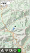
There appears to be an interesting alternative from la Rebolla (just past Mieres) which is marked in red (right-hand side) on the map. Next time I'm going to sus this out. It looks as though it has far less asphalt as the main Camino and heads straight up the fall line to follow the mountain tops to the outskirts of Oviedo.

Cheers,

The German

Screenshot_2015-11-30-08-42-07.webp Screenshot_2015-11-30-08-42-07.webp Screenshot_2015-11-30-08-42-07.webp
 
Hi Kev,

I'm happy to hear that you enjoyed the del Salvador. I think that if I were to walk it again, I would do a 5 day itinerary and try the different albergues such as the one you mentioned above.

There appears to be an interesting alternative from la Rebolla (just past Mieres) which is marked in red (right-hand side) on the map. Next time I'm going to sus this out. It looks as though it has far less asphalt as the main Camino and heads straight up the fall line to follow the mountain tops to the outskirts of Oviedo.

Cheers,

The German

View attachment 22641 View attachment 22641 View attachment 22641

Hi, Herman,

Now that I'm pretty set on adding a day to my Camino del Salvador this summer, I will spend a night in Mieres. (seems you are thinking that way, too - I've decided on La Robla, Poladura, Bendueños, and Mieres, if all goes well). The red line on this map looks very enticing. Where did you find it and what can you tell me about it? The Mieres-Oviedo part of the Salvador is probably my least favorite and as you note, almost all asphalt. It would be great to have an off road alternative in those lovely hills. Thanks, buen camino, Laurie
 
Hi Laurie,

A warm summer camino sounds great, not to mention the benefits of having a lighter pack! I've already made a mental summer pack inventory even without the prospects of any summer camino soon... one must dream.

OK, in regards to the map: I always have my electronic Swiss Army Knife with me aka. Sony Xperia Z1 Compact (Android), which fits nicely into a front pocked without being obtrusive. Not only does it have a fantastic 20MB camera and a GPS chip, it also supports GLONASS (Russian satellite
positioning network), which comes in handy when you can't get a GPS signal. I've never not had a positioning fix.

The App that I'm running is called Alpine Quest, which is available in the Play Store for a once off price of €6.99 and is, in my opinion, worth every cent.

https://play.google.com/store/apps/details?id=psyberia.alpinequest.full

Once the App is up and running, there are many online (and free) map sources you can connect to which are listed in the App itself. You'll need Wi-Fi of course. The beauty of this App, is that once you've decided which map you like (there are many) and where you will be walking, you can simply download this section of the map to your SD card for use at a later time. The map I always use, is the topographical "Outdoor Map", which as you can see, has not only the caminos and GRs marked, but also the contour lines which are particularly useful. There are other maps such as Landscape, Cycle/Hike, Mapquest Open and also the Bing and Google satellite aerial maps. You can also load in a .gpx track (plenty available at Wikiloc (http://www.wikiloc.com/) so that the camino is also visible as a track... useful when seeing what detours and side trips others have walked in the past.

I hope that is of use to you.

Buen Camino,

The German
 
A selection of Camino Jewellery
The bar in Parejes was open Sunday 1st June 2014. Yes they are a lovely and friendly couple and i had a few drinks there but ate at the albergue having arranged to do so with the other 5 pilgrims walking the same stages as me. We had all met at the nice albergue in La Robla, and had ate together at the Casa Rural when we stayed in Polaura de la Tercia. Marisa in Parejes was a lovely hospitalera and provided a nice vegetarian meal for us as two of the girls were vegetarian. On our last night in Oviedo we realised that we had only seen one other pilgrim all the way!
 
Hi Laurie,

A warm summer camino sounds great, not to mention the benefits of having a lighter pack! I've already made a mental summer pack inventory even without the prospects of any summer camino soon... one must dream.

OK, in regards to the map: I always have my electronic Swiss Army Knife with me aka. Sony Xperia Z1 Compact (Android), which fits nicely into a front pocked without being obtrusive. Not only does it have a fantastic 20MB camera and a GPS chip, it also supports GLONASS (Russian satellite
positioning network), which comes in handy when you can't get a GPS signal. I've never not had a positioning fix.

The App that I'm running is called Alpine Quest, which is available in the Play Store for a once off price of €6.99 and is, in my opinion, worth every cent.

https://play.google.com/store/apps/details?id=psyberia.alpinequest.full

Once the App is up and running, there are many online (and free) map sources you can connect to which are listed in the App itself. You'll need Wi-Fi of course. The beauty of this App, is that once you've decided which map you like (there are many) and where you will be walking, you can simply download this section of the map to your SD card for use at a later time. The map I always use, is the topographical "Outdoor Map", which as you can see, has not only the caminos and GRs marked, but also the contour lines which are particularly useful. There are other maps such as Landscape, Cycle/Hike, Mapquest Open and also the Bing and Google satellite aerial maps. You can also load in a .gpx track (plenty available at Wikiloc (http://www.wikiloc.com/) so that the camino is also visible as a track... useful when seeing what detours and side trips others have walked in the past.

I hope that is of use to you.

Buen Camino,

The German

Oh, dear that's what I was afraid of. I am not the high tech pilgrim. I wonder if this particular alternative is well marked. I think your phone plus app sounds great, but I'm not yet quite ready to take that plunge. At this point I've got a GPS that I may or may not bring with me this year, and I can download tracks from wikiloc but have not been able to find any tracks on Wikiloc that follow the "red line" on your Alpine Quest map. I will keep hunting and maybe Ender can help out. Thanks, Laurie
 
Oh, dear that's what I was afraid of. I am not the high tech pilgrim. I wonder if this particular alternative is well marked. I think your phone plus app sounds great, but I'm not yet quite ready to take that plunge. At this point I've got a GPS that I may or may not bring with me this year, and I can download tracks from wikiloc but have not been able to find any tracks on Wikiloc that follow the "red line" on your Alpine Quest map. I will keep hunting and maybe Ender can help out. Thanks, Laurie

Hi Laurie,

It's definitely a GR trail, so theoretically it should be marked. The GR markings all the way along the camino up until this point have been good, so I have high expectations. From what I've read on Google Earth it could be the GR 105.1

Cheers,

The German
 
A selection of Camino Jewellery
Oh, dear that's what I was afraid of. I am not the high tech pilgrim. I wonder if this particular alternative is well marked. I think your phone plus app sounds great, but I'm not yet quite ready to take that plunge. At this point I've got a GPS that I may or may not bring with me this year, and I can download tracks from wikiloc but have not been able to find any tracks on Wikiloc that follow the "red line" on your Alpine Quest map. I will keep hunting and maybe Ender can help out. Thanks, Laurie


OK, here's the gps track on Wikiloc:

http://www.wikiloc.com/wikiloc/imgServer.do?id=5946505
 

Attachments

  • 5946539.webp
    5946539.webp
    82.2 KB · Views: 1

So, it looks like this track ends at the intersection with the GR-105, which goes from Covadonga to Oviedo, http://www.wikiloc.com/wikiloc/view.do?id=4781975

The 105.1 meets the GR-105 east of La Grandota and it looks like the GR-105 would then take you about 6-8 km west till the end point at a town called El Caldero. That´s about 4 km outside of Oviedo and it looks like an easy walk in, no hugely busy roads.

Overall, the elevation gain doesn't look like it has anything too dramatic, nor are there any precipitious descents that I can see.

Hmmmm..... This is something to consider, because that Mieres-Oviedo route is sure a lot of asphalt!

I think there may be some forum members who have walked from Covadonga to Oviedo on the GR 105. Buen camino, Laurie
 
Just a quick follow-up to say that before anyone decides to walk this alternative, you should take a look at some of the comments on the various Wikiloc tracks. It doesn't seem that this route is one that is well marked or well-maintained. I am likely to pass if I'm walking alone, but if i were to meet someone in Mieres who wanted to give it a try, I'd be happy to go for it.
 
...and ship it to Santiago for storage. You pick it up once in Santiago. Service offered by Casa Ivar (we use DHL for transportation).

❓How to ask a question

How to post a new question on the Camino Forum.

Featured threads

❓How to ask a question

How to post a new question on the Camino Forum.

Featured threads

Forum Rules

Forum Rules

Camino Updates on YouTube

Camino Conversations

Most downloaded Resources

This site is run by Ivar at

in Santiago de Compostela.
This site participates in the Amazon Affiliate program, designed to provide a means for Ivar to earn fees by linking to Amazon
Official Camino Passport (Credential) | 2024 Camino Guides
Back
Back
Top