• Remove ads on the forum by becoming a donating member. More here.

Search 74,075 Camino Questions

Tablets with built-in GPS function

jhpdx

New Member
I purchased a Samsung Galaxy Note 8.0 in advance of traveling to SW France to walk 400 miles on the GR65 trail in September, 2013. I specifically wanted the GPS function. I wanted a live map. I can report that it worked beautifully in conjunction with Google Maps.

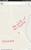
I was finding free WIFI once a day or so and with that I would go to Google Maps, select areas that I would be walking soon and typed “ok maps”. Google would download their map for the section I selected and it would get cached. I loaded up several sections. When I left my WIFI zone, I had a detailed map on my tablet. Really detailed. It never took more than a minute for the GPS ‘blue dot’ to appear almost exactly where I was standing. Most often it took a few seconds. People occasionally asked ME for directions … and I don’t speak French.

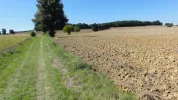
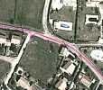
If this system allows it, I'll attach some photos to illustrate how tiny a ‘road’ Google put on my tablet. The photos show the GR65 trail. (If this system does not allow photos, you can find them at ( https://plus.google.com/u/0/115064888683864942892/posts )

I can’t tell you how satisfying it was to always know where I was. I’m capable of walking about 15 miles a day. I have met people who went in a wrong direction and added many kilometers to their days' walk. If the days' destination was going to be too long for me, I would look for a shortcut. I'm one of those folks who is just fine with walking on a country road rather than the designated trail.

There are a flood of tablets reaching the market. Having a GPS chip built into a tablet is a must have feature for me.
 

Attachments

  • French satellite view of trail.webp
    French satellite view of trail.webp
    45.3 KB · Views: 36
  • Screenshots_2013-10-24-16-59-43.webp
    Screenshots_2013-10-24-16-59-43.webp
    36.9 KB · Views: 34
  • DSC00459.webp
    DSC00459.webp
    1.6 MB · Views: 31
Get a spanish phone number with Airalo. eSim, so no physical SIM card. Easy to use app to add more funds if needed.
I purchased a Samsung Galaxy Note 8.0 in advance of traveling to SW France to walk 400 miles on the GR65 trail in September, 2013. I specifically wanted the GPS function. I wanted a live map. I can report that it worked beautifully in conjunction with Google Maps.

I was finding free WIFI once a day or so and with that I would go to Google Maps, select areas that I would be walking soon and typed “ok maps”. Google would download their map for the section I selected and it would get cached. I loaded up several sections. When I left my WIFI zone, I had a detailed map on my tablet. Really detailed. It never took more than a minute for the GPS ‘blue dot’ to appear almost exactly where I was standing. Most often it took a few seconds. People occasionally asked ME for directions … and I don’t speak French.


Thanks jhpdx, that's very helpful and informative.
Mendi btw- there aren't yellow arrows on the GR65- or if there are- sometimes they are for local regional trails. It's red and white bars you look for on the GR 65.
Margaret
 
Holoholo automatically captures your footpaths, places, photos, and journals.
So much simpler following the yellow arrows.

Buen Camino!
You've missed a couple ideas. There are times when the trail markings have disappeared, maybe because of a wrong turn. Further, there are times when you want/need to go off trail and need to figure out how to get back.
 
oooops problem with my reply being buried in the quote... What I wanted to reply was:
Thanks jhpdx, that's very helpful and informative.
Mendi btw- there aren't yellow arrows on the GR65- or if there are- sometimes they are for local regional trails. It's red and white bars you look for on the GR 65.
Margaret
 
The 2024 Camino guides will be coming out little by little. Here is a collection of the ones that are out so far.
oooops problem with my reply being buried in the quote... What I wanted to reply was:
Thanks jhpdx, that's very helpful and informative.
Mendi btw- there aren't yellow arrows on the GR65- or if there are- sometimes they are for local regional trails. It's red and white bars you look for on the GR 65.
Margaret

You´re right on the GR´s including GR 65 there are no yellow arrows there are red and white bars as on the PR´s there are yellow and white bars.
When I hike I prefer to use a map and compass.:)

Buen Camino!
 
Those who have never missed an arrow think it so easy. Others, like me, know how easy it is to miss an arrow and how difficult it can be to recover from that.

If my memory does´t play any tricks on me we have talked about this on another thread. I haven´t stated to have not missed a yellow arrow. I have and the simple solution is turn round and walk a short distance to locate it.

I understand that some people prefer to use a GPS and others prefer to use a map and compass. I belong to the second group. But I must say that on the Camino Frances as well as on the other two I followed the yellow arrows no GPS and no compass and map either. I must say on the Camino Portugues de la Costa there are sections where there is no yellow arrows at all ( e.g. Vigo) I found my way without much problem. But I do understand some would´t and prefer the use of a GPS.

Buen Camino!
 
When I hike I prefer to use a map and compass.:)
Ah, so you mean the yellow arrows are not enough? ;)

Myself I used an iPhone on all my caminos.
Google maps is great. Love it. I'm surprised it can find the smallest path in very remote areas, and lead me right. Without it, I would still be on the camino. Or, rather, still trying to find the camino. :)
 
Holoholo automatically captures your footpaths, places, photos, and journals.
Ah, so you mean the yellow arrows are not enough? ;)

Myself I used an iPhone on all my caminos.
Google maps is great. Love it. I'm surprised it can find the smallest path in very remote areas, and lead me right. Without it, I would still be on the camino. Or, rather, still trying to find the camino. :)

When I walk the Camino I flow the yellow arrows and use nothing else.

When I hike in the mountains I use a map & compass.

Buen Camino!
 
Back to topic……..

How long does the battery @jhpdx ? Do you have to use a backup battery or a juicer?

Buen Camino!
 
I had been thinking about a GPS. I have a smart phone but wasn't sure I would be able to use on the camino. I was concerned about snow/rain or whatever obscuring the arrows. Not to mention I can't find my way out of a paper bag half the time! If I'm thinking i should go left I will inevitably find I should have gone right. So thanks for the post! Very helpful. :)
 
Perfect memento/gift in a presentation box. Engraving available, 25 character max.
If my memory does´t play any tricks on me we have talked about this on another thread. I haven´t stated to have not missed a yellow arrow. I have and the simple solution is turn round and walk a short distance to locate it.
This might have worked for you - my experience was different. Finding the arrows on the way back was just as difficult as finding them on the way forward.
 
So did you have a 3G sim in the tablet then? Or how was it working out of WiFi zones?

The OP mentions downloading the maps . I'm guessing the OP didn't have 3G.. You need 3G if you want real time directions. But without it you can still use the tablet like a super paper map. The GPS will show your location. It'll show any other info you've marked on the map. It's usually easy enough to just point yourself in the right direction while walking. Walking the need for step by step directions isn't that great. You might not pick the quickest route but you can manage without the directions.
 
The one from Galicia (the round) and the one from Castilla & Leon. Individually numbered and made by the same people that make the ones you see on your walk.
So did you have a 3G sim in the tablet then? Or how was it working out of WiFi zones?

You do not need any connection for GPS. If, as the OP stated, you have a map downloaded there is no need for any Wi fi or 3G.

For anyone going to France, check out the Michelin map app. For about $10 you can download the entire country and have a really high quality zoomable map, with a nice GPS location dot. The google maps are free but no one maps France like Michelin. We put it on the phone and Ipad and it was great while driving. The map zooms up to a scale which includes the major GR's, and restaurants and hotels can be found as well, all without a connection.

As far as the yellow arrows go, I invite anyone to hike something like the new GR653A, Voie Aurelienne from Italy to Arles with just a map and compass and the trail markers. GPS has really taken a headache out of the pilgrim's trip. (yep, I know how to use a map and compass, I'm a geologist)

A little off topic....but I really want to thank newfydog for sending me a VdlP GPS map for use with MotionX. He sent it to me and I did get it downloaded and on my iPhone long before I left. I know little (nothing) about using GPS routing so really did not think much about it.

I was walking alone (no one else on the camino:eek:) in August. I got off the Camino in the first couple of days in a very poorly marked stretch. I reached a moderate use road and had no idea which way to go or how to get back on track. I started to look at various maps on iPhone and found that the MotionX app seemed to have an orange line several KMs from me. I took a closer look at it and realized that it went thru the town where I was trying to get to for the night. I was able to follow the highway and connect with the overnight stop. In the morning I set out following the normal Camino markers and later looked at the MotionX app again. I suddenly realized that the "orange line" was the GPS routing the newfy had sent me. Pretty stupid...but I had forgotten about it and had no previous experience with using it.
The short version of this story is that I followed the routing all the way to Santiago. I only used it when I was not sure of the proper way to go. Saved me many, many times from long errors and gave me assurance when I was worrying about the route.
The VdlP is very badly, and even erroneously, marked in many sections....or maybe it was the heat in August cooking my brain. (45 degrees for about 8 straight days).

At any rate....THANKS to newfydog for getting me into the world of GPS maps. I would not think of going on an unknown route now without the GPS routing.....except I still have no idea how to find one without someone holding my hand.

Ed
 
Glad I could help grayland! I read this thread while taking a break from putting together a GPS and Google earth file of the Stevenson trail....

Nothing is more irritating than ending up backtracking or walking on the highway, and in this brave new world, a little app on the phone you already have can work miracles.
 
The focus is on reducing the risk of failure through being well prepared. 2nd ed.
Glad I could help grayland! I read this thread while taking a break from putting together a GPS and Google earth file of the Stevenson trail....

Nothing is more irritating than ending up backtracking or walking on the highway, and in this brave new world, a little app on the phone you already have can work miracles.
If you are willing to share I have created a "GPS Tracks" section i the Camino Resource section:
http://www.caminodesantiago.me/community/resources/categories/gps-tracks.10/

Maybe you can upload it there?

Saludos,
Ivar
 
sure Ivar, i have a big chaotic folder full of various camino traces. I'll sort through it and post some up. I have long thought we needed one spot to dump them all.

You might add category for Google Earth .kmz files as well.
 
Train for your next Camino on California's Santa Catalina Island March 16-19
Join the Camino cleanup. Logroño to Burgos May 2025 & Astorga to OCebreiro in June
Get a spanish phone number with Airalo. eSim, so no physical SIM card. Easy to use app to add more funds if needed.
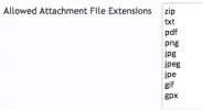
This is the dropbox link for .gpx files covering the Camino Frances from SJPP to SdC. These files were originaly posted by someone else on the old forum last year. I have been unable to find the post again but I had saved the files. Thanks to the OP for these great files, all credit is due to him.

https://www.dropbox.com/sh/0pztqglpix5wtff/_tyZJZKhAH
Beautiful! Thank you!

I just uploaded the zip file with all the gpx files to the resource section and handed the ownership of it over to you. Have a look here:
http://www.caminodesantiago.me/comm...an-pied-de-port-to-santiago-de-compostela.34/

Thanks again!
Ivar
 
Sorry to read you had problems.:(

Buen Camino!
I might have seen getting a little lost as s problem early on. Later it was just part of the adventure finding a way forward without having to retrace my steps. It would not have been possible using Brierley alone - having a GPS loaded with topo mapping made it possible. So would have carrying paper topo maps, but much less conveniently.
 
Ideal pocket guides for during & after your Camino. Each weighs only 1.4 oz (40g)!
I might have seen getting a little lost as s problem early on. Later it was just part of the adventure finding a way forward without having to retrace my steps. It would not have been possible using Brierley alone - having a GPS loaded with topo mapping made it possible. So would have carrying paper topo maps, but much less conveniently.

Sorry to hear you had problems but with the new GPS info here from the forum you shouldn´t have any problem what so ever.:)

Buen Camino!
 
Beautiful! Thank you!

I just uploaded the zip file with all the gpx files to the resource section and handed the ownership of it over to you. Have a look here:
http://www.caminodesantiago.me/comm...an-pied-de-port-to-santiago-de-compostela.34/

Thanks again!
Ivar

It is working! I added a .gpx and a .kmz file of the Frances. They have the whole route in one convenient file.

Many files I download are split into many short segments. The files are not that big, so it is nice to have just one longer track to load into you device. My red line posted in my google earth thread was segmented, as is the file Ivar just put up
I've used mapsource to link up many traces for various routes and will post some more in a bit.
http://www.caminodesantiago.me/comm...-and-travel-the-camino-in-google-earth.12695/

I downloaded it and it looks good! :)

Update: had some problems with Le Puy. Frances went well.
 
€2,-/day will present your project to thousands of visitors each day. All interested in the Camino de Santiago.
I loaded a Le Puy google earth track, then deleted it and replaced it with one I liked better. Is it working now?
 
Back to topic……..

How long does the battery @jhpdx ? Do you have to use a backup battery or a juicer?

Buen Camino!
I did not have or need a battery backup. My tablet had plenty of power to pull up a map whenever I needed it, run a tracking program all day long, and take as many photos as I wanted. I always found a place to recharge once I landed at a gite.
 
Get a spanish phone number with Airalo. eSim, so no physical SIM card. Easy to use app to add more funds if needed.
So did you have a 3G sim in the tablet then? Or how was it working out of WiFi zones?
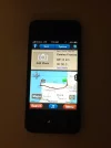
My tablet is WIFI only. It has no sim and no cell phone capability. Once I left a WIFI zone, I would turn off the WIFI function to save power but I would have the GPS function running. I'm attaching a photo of what that looks like on my tablet. (I would also turn off the Bluetooth function to save power.)

My tablet comes with a GPS chip and function. It's like a GPS device you might buy for your car. Screenshots_2013-10-27-16-02-01B.webp I've not kept up on which tablets do and do not have a GPS chip. Do your research if you're wanting a tablet that will show your location on a map when you're on a trail.
 
Last edited:
The OP mentions downloading the maps . I'm guessing the OP didn't have 3G.. You need 3G if you want real time directions. But without it you can still use the tablet like a super paper map. The GPS will show your location. It'll show any other info you've marked on the map. It's usually easy enough to just point yourself in the right direction while walking. Walking the need for step by step directions isn't that great. You might not pick the quickest route but you can manage without the directions.
This is correct.
 
You need 3G if you want real time directions
Actually, if you load a routable offline map, real time directions require no 3G. I use routing function driving. On a camino, I'll have the route loaded and only have used routing a few times to find a hotel or something way off route.

Walking the need for step by step directions isn't that great. You might not pick the quickest route but you can manage without the directions.

With a track loaded, the need for directions is non-existent. You just keep your little blue location marker on the red line.


MOTIONX.webp
 
€2,-/day will present your project to thousands of visitors each day. All interested in the Camino de Santiago.
Actually, if you load a routable offline map, real time directions require no 3G. I use routing function driving. On a camino, I'll have the route loaded and only have used routing a few times to find a hotel or something way off route.


With a track loaded, the need for directions is non-existent. You just keep your little blue location marker on the red line.


View attachment 6634
Hello Newfy,
Need some help understanding all this fancy Technology please. :)
Ok. I have a Apple 4S cell that I plan to get a Spanish SIM for in Spain. I am starting at SJPdP and going on to Fin and Muxia late May 2014. I would absolutely love to have the capability of knowing where I am on the Camino and if possible know home many Miles/ KM's I have walked in any particular day. It sounds like the technology that you have and used will do that for me?? Would it be possible for you to develop an "How To" for all of us that lists the steps of what to down load and where to get it for our cells? I am pretty sure that you would be a Hero if you did this and eligible to wear a Red Cape!!! Thanks.

Ed
 
I was under the impression that the GPS required 3G or some kind of connectivity... if not, great! I'm about to buy a Samsung Galaxy Note 3 (half phone half tablet...). Want to be able to skype and email from it, whatsapp etc to stay in touch, either with WiFi, or perhaps a local sim for internet, so this should work.
 
3G or even wifi makes it quicker to get a GPS lock. If you're traveling from Thailand to Spain your device will take a while to get a lock on it's own. The GPS will wonder why everything has changed. Even worse if you're in a large city with tall buildings blocking everything.
 
The focus is on reducing the risk of failure through being well prepared. 2nd ed.
3G or even wifi makes it quicker to get a GPS lock. If you're traveling from Thailand to Spain your device will take a while to get a lock on it's own. The GPS will wonder why everything has changed. Even worse if you're in a large city with tall buildings blocking everything.
and if it 'finds' it first with Wifi, will it then locate it on it's own when out of Wifi zones?
 
Many thanks I have sucessfully loaded the files into my android phone.

Hopefully, I will never need them, just like the survival bag that I have carried for decades and thousands of miles.

Belt and braces
 
Holoholo automatically captures your footpaths, places, photos, and journals.
I was under the impression that the GPS required 3G or some kind of connectivity... if not, great! I'm about to buy a Samsung Galaxy Note 3 (half phone half tablet...). Want to be able to skype and email from it, whatsapp etc to stay in touch, either with WiFi, or perhaps a local sim for internet, so this should work.

Just to be very clear......you DO NOT need any type of internet or data connection for your phones GPS function to work.
Check it out for your self at home by turning off WiFi and data and going out and use the GPS

The trick is that the Apps use the internet to load the current locations map to show you your location on a map. It will normally just show you as a dot on a blank page without a map.

You need to download a map of the area you will be walking in.
Not as difficult as it may sound and there is a lot of specific info offered here on the forum by newfydog and others.
 
3G or even wifi makes it quicker to get a GPS lock. If you're traveling from Thailand to Spain your device will take a while to get a lock on it's own. The GPS will wonder why everything has changed. Even worse if you're in a large city with tall buildings blocking everything.

My experience has been that the first fix off the plane (or after not being used for days) can take a minute or more. After that it is very fast with or without wifi. When I use my phone I keep it turned off to save battery and check it at intersections. A fix takes 1-4 seconds when I turn it on, without 3g or wifi.
The $470 Garmin Montana GPS unit uses no internet connection, and your phone does not need one either.
 
Hello Newfy,
Would it be possible for you to develop an "How To" for all of us that lists the steps of what to down load and where to get it for our cells?

For the iphone:
-Go to the app store and buy the motion gps app. It costs $1.99.
-Download a .gpx file of the Frances. One is available here: http://www.caminodesantiago.me/community/resources/camino-frances-on-one-gps-track.35/
-email that .gpx file to: gpsimport@motionx.com
-They will send you the track in a return email. Open that email with your phone and it will load into motionX
-To download a base map which will work without 3g, open the app, hit menu, map, maps, mapdownloads. Google it for better instructions than I can give.

There are many other apps and ways to do this. Here's some threads you might read:
http://www.caminodesantiago.me/community/search/153288/?q=newfydog motionx&o=date

Here's what my phone looks like. I can zoom that track in until I can see what side of the trail it was recorded on. iphone frances.webp
 
Last edited:
€2,-/day will present your project to thousands of visitors each day. All interested in the Camino de Santiago.
My experience has been that the first fix off the plane (or after not being used for days) can take a minute or more. After that it is very fast with or without wifi. When I use my phone I keep it turned off to save battery and check it at intersections. A fix takes 1-4 seconds when I turn it on, without 3g or wifi.
The $470 Garmin Montana GPS unit uses no internet connection, and your phone does not need one either.

Most phones offer AGPS to speed up lock on. Some add WiFI positioning . Both speed things up and improve fix in tough areas.
 
Most phones offer AGPS to speed up lock on. Some add WiFI positioning . Both speed things up and improve fix in tough areas.
I'm sure that is all true, but the point we have tried to get across in all of these threads is that GPS is a stand alone function. From Canterbury to Rome, Prague to Santiago, GPS alone without 3G or Wi-Fi has given nearly instant positioning with accuracy of spitting distance. You can't make calls, read your email, or shop on ebay when out of service. but you can measure the length of your stride with just GPS. Don't waste any 3G minutes or battery power augmenting the GPS function. Turn them off and it will still work perfectly.

Here's a track where I made a wrong turn. Didn't take long to realize it. No 3g or wifi needed

wrong turn 2.webp
 
Last edited:
Holoholo automatically captures your footpaths, places, photos, and journals.
For the iphone:
-Go to the app store and buy the motionX app. It was about $0.99.
-Download a .gpx file of the Frances. One is available here: http://www.caminodesantiago.me/community/resources/camino-frances-on-one-gps-track.35/
-email that .gpx file to: gpsimport@motionx.com
-They will send you the track in a return email. Open that email with your phone and it will load into motionX
-To download a base map which will work without 3g, open the app, hit menu, map, maps, mapdownloads. Google it for better instructions than I can give.

There are many other apps and ways to do this. Here's some threads you might read:
http://www.caminodesantiago.me/community/search/153288/?q=newfydog motionx&o=date

Here's what my phone looks like. I can zoom that track in until I can see what side of the trail it was recorded on. View attachment 6636
Hello Newfy, well I got as far as "To download a base map which will work without 3g, open the app, hit menu". After I hit menu I do not see anything that says map, maps ect.....
 
As far as the yellow arrows go, I invite anyone to hike something like the new GR653A, Voie Aurelienne from Italy to Arles with just a map and compass and the trail markers

If this is the route from Menton to Arles, I did it with just map and trail markers last year and had no problems.
 
...and ship it to Santiago for storage. You pick it up once in Santiago. Service offered by Casa Ivar (we use DHL for transportation).
Last edited:
If this is the route from Menton to Arles, I did it with just map and trail markers last year and had no problems.
That's good, because there were big parts missing a few years ago when we did it.. The guidebook author Paul Chinn wrote "Your trace was really valuable. The signing is still not up to GR standards and so we had to depend on the GPS a great deal in the central section"
 
Ideal pocket guides for during & after your Camino. Each weighs only 1.4 oz (40g)!
The middle button on the right is not "map"?

you might check out this:
http://gps.motionx.com/mobile/iphone/guides/
Perhaps I have the incorrect app? On the apple store when you do a search for "motionX app." you get two apps. One called Motionx GPS Drive for 0.99 and one called MotionX GPS for 1.99. Since you had indicated it was 0.99, I paid for it, and then downloaded the 0.99 one. Is this not the correct one? Just trying to figure out why this worked for others and not me...Thx. So frustrating................sheesh.
 
Sounds like they split it into two apps. I use motion x gps. It was a bargain back in the day......
 
The correct app is simply MotionX GPS. The one with "drive" in the name is for automobile navigation and won't meet you Camino needs.

I used the MotionX GPS app on my iPhone on the Camino del Norte earlier this month and it did great with the downloaded maps. A couple of times I took a wrong turn and MotionX was a big help in getting me back on track, quickly.
 
€2,-/day will present your project to thousands of visitors each day. All interested in the Camino de Santiago.
Thanks egar. I edited my post to prevent other people from making that mistake. Halfdome----If we meet out on the trail I owe you a 99 cent beer!
 
I used the MotionX GPS app on my iPhone on the Camino del Norte earlier this month and it did great with the downloaded maps. .

I found that the app would use many different maps online (such as Google), but would only download open source maps, which they call "motionX road or terrain". They were quite good in England and not bad in France. How were the Spanish maps?
 
I found that the app would use many different maps online (such as Google), but would only download open source maps, which they call "motionX road or terrain". They were quite good in England and not bad in France. How were the Spanish maps?

I downloaded the MotionX terrain maps on the Camino and the MotionX road maps for a week in Barcelona. Both works well. They are based on OpenCycleMaps and OpenStreetMaps. They seem to have good coverage in Europe.

When you are trying to follow a pre-recorded track, the maps are a little less important and your proximity to the track is more important anyway.
 
The one from Galicia (the round) and the one from Castilla & Leon. Individually numbered and made by the same people that make the ones you see on your walk.
I purchased the MotionX GPS for 1.99.

I was trying to download a background Map when the "track" I had downloaded from the Newfydog link and emailed came back into my inbox - when I opened it it had both the track and background map and so "I was good to go"

Good luck
 
Have any of you tried Orux maps on Android? I have been using it for over a year in UK with OS maps (now sadly unavailable for free) at 25000 scale for all my walking. It has been extremely reliable and in my mind has astonishing functionality for a free app. Currently on my Note 2 when I view the area I am going to use, the software downloads the fee mapping that it subsequently stores for later use. I can then either plot my own route or download one from elsewhere. When starting my walk I set the recording function and occasionally view the plot as I go just to ensure the position arrow matches the route I have chosen. At the end of the walk my actual track has been stored and can be checked for distance, speed, height gained etc. As long as I have wifi when I download the maps there is no further need for connection of any kind, wonderful!

My phone will last a couple of days battery on walking with just viewing to check position, taking pictures, sending and receiving the odd email, text and phone call. Has a nice big screen, bright and clear enough for video. Just love it.

Orux maps is a Spanish product and seems to work really well with IGN(ESP) mapping. I'm looking forward to using it on the Camino next year.

Screenshot from my phone, this at 25000 but smaller are available too
Screenshot_2013-10-30-17-29-06_zpsc6c9d8fe.png
 
Last edited:
For logging tracks I have found My Tracks to be one of the best free android apps. Little or no battery use and you can play your route on Google Maps or export track in gpx or kmz
 
3rd Edition. More content, training & pack guides avoid common mistakes, bed bugs etc
Thanks for the tips. My wife has an Android and I have yet to find something I like, though I have not worked too hard at it.....
 
Something a little strange happening here - received email notifying me of a reply from jhpdx but I cannot see it here so I'll copy it in

"looked at Samsung's Galaxy Note 3 specs (below) and do not see that it has a GPS receiver. It does say that it will do 'GPS Navigation'. What is not clear to me is how it does this navigation. If the Note 3 uses only WIFI signals, you should be able to navigate in most towns just fine. However, once you're on a trail away from WIFI, you'd be out of luck because WIFI signals would disappear. If the Note 3 uses 3G signals for navigation, you have to depend on cell coverage and that might be enough in most cases. If a phone or tablet has a GPS chip (Galaxy Note 8.0 for instance), you can be pretty much anywhere in the world and have a live map. To get into this a little deeper, it appears to me that the Note 8.0 uses the Russian GLONASS system...not the America GPS system."

Let's be very clear the Galaxy Note 3 has more sensors than you can shake a stick at, GPS being one of the many. There is absolutely no need to have either wifi or phone data connections for your navigation on the trail. If you wish to use email, sent pictures, find accommodation or download new maps then that is a different matter but rest assured I know of no device that would perform your needs better.

On Tuesday I did the Yorkshire 3 peaks challenge a gruelling 24 mile round with some 5500 ft of climbing in the most atrocious conditions of heavy rain and cold winds. Before leaving home I downloaded a track of the route into Orux. I then, still connected to wifi, traced the route on the screen as the software download the detailed mapping into its catched storage. With this done we set off with no ability to connect to wifi or phone data in the area. Not only no data but no phone connection at all. The big screen was easy to see as we battled round finishing some hour after dark but with the phone battery still over 50% charged. Calling in at a pub on the way home where there was a phone data signal so I was able to send some (low res) pictures to family as we had a celebratory meal. The system is brilliant and I will have no problem using it on the full Camino if I can do it next year.
 
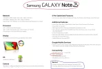
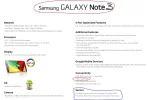
Yes, something strange did happen. Yesterday I did post a reply and within a minute realized I had made an error so I deleted my post (the one you pasted back in). I ran out of time to come back to it. I was writing about the lack of clarity in the specifications of the Galaxy Note 3 from Samsung. When I looked a second time at the image I attached, I saw my mistake.

Below is a link and image to Galaxy Note 3 specifications. This page is a little different than the one I found yesterday but more complete. I learn a couple things here. 1) Samsung does not call GPS a sensor. It's under 'Conectivity'. 2) Samsung uses the Russian GLONASS system for global positioning. I had to go to Wikipedia to come up to date on GLONASS. I usually think of the American system which is called GPS when I think of GPS.

What people on this board want to know, I think, is can I use my phone/tablet/computer to get a live map without a 3G cell or WIFI connection? If you have a Samsung Note 8 or Note 3, the answer is yes. The key to knowing that is looking at the specifications and understanding these devices have 'connectivity' to GLONASS which is one of the GPS systems.
---------------------------------------------------------------------------------------------------------------------
http://www.samsung.com/global/microsite/galaxynote3-gear/spec.html

Capture.webp
 

Attachments

  • Capture.webp
    Capture.webp
    77.4 KB · Views: 5
Last edited:
The focus is on reducing the risk of failure through being well prepared. 2nd ed.
What people on this board want to know, I think, is can I use my phone/tablet/computer to get a live map without a 3G cell or WIFI connection? If you have a Samsung Note 8 or Note 3, the answer is yes. The key to knowing that is looking at the specifications and understanding these devices have 'connectivity' to GLONASS which is one of the GPS systems.
I don't think it is correct to say that one can get a 'live map' without at 3G/wifi connection. Neither GPS nor GLONASS provide map data, they just allow the GPS device to determine its location. If you don't have the mapping data cached, you won't get that from the GPS/GLONASS constellations - you will need to go online to get it.

Regards,
 

❓How to ask a question

How to post a new question on the Camino Forum.

Most read last week in this forum

I came across this in my daily reading. It may be of interest to our peregrinas. It seemed very clever to me. See the article here: https://adventure.com/review-gnara-hiking-trousers/ Also...
Heyy! How many litters backpack did you have? I’m thinking Deuter 30l or 36l. What do you think? Some people say 30l is completely enough and some wish they would have little more space…
I am walking the Camino Frances for the whole month of May (April 22nd - June 1st), and am wondering whether I should opt for waterproof shoes/boots? I have seen mixed messages online - on the one...
Am busy doing a spring clean/room tidy and having a look at my travel/camino clothes, took photos just for fun...for my next future travels. Missing the long sleeve merino, as am looking at an...
OK, here is a question for the Tech savvy folks...... I'm trying to track down some noise cancelling ear buds for use on our flight to the Camino. And will probably also use in Albergues...

Featured threads

❓How to ask a question

How to post a new question on the Camino Forum.

Featured threads

Forum Rules

Forum Rules

Camino Updates on YouTube

Camino Conversations

Most downloaded Resources

This site is run by Ivar at

in Santiago de Compostela.
This site participates in the Amazon Affiliate program, designed to provide a means for Ivar to earn fees by linking to Amazon
Official Camino Passport (Credential) | 2024 Camino Guides
Back
Back
Top