Friend from Barquinha
Veteran Member
- Time of past OR future Camino
- None yet; perhaps the Portugese (2021?)
As recent posts have described, the heat in the Lisbon/Santarém section of the central Portuguese Caminho is pretty brutal these days.
Vila Nova da Barquinha, our "hometown" in Portugal, is between Golega and Tomar, and for many of the walkers of this caminho, about Day 5 and the almost-last day of the hottest section.
Here's a tip about a perhaps slightly pleasanter detour through our part of town, the no-longer-stand-alone village of Moita do Norte, north of the railroad tracks as you head from VNdBarquinha north into Atalaia.
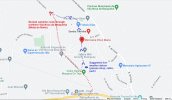
On the map below, you can see the usual route into Atalaia. It includes a steady, no-shelter climb up the hill from the Junta da Freguesia--town hall.

If you'd like to get a bit of shade along the way, you can follow the blue-dotted route shown above, rather than the red-dotted one. You have an abrupt climb (actually stairs along the road) for the first short section as far as the chapel on your right, but from that point on, it's flat, and you've gained all the elevation you would have gained on the usual route, but much more quickly.
From that point, you have a walk through the old part of the village heading straight on north past the chapel, past a small grocery where you can pick up fruit or cold drinks, and two cafés, one on either side, as you walk a bit further. (There is also a tiny store on your right just past the Mercearia DÁvó Maria--the grocery shop--that sells things like sewing stuff and sundries. It is hard to recognize as a shop, but carries lots of useful odds and ends.)
At the top end of the street at a small park (I think with a drinking fountain), you turn left and walk west to rejoin the main route. This can make a reasonable mid-morning break. (We usually see the peregrinos coming past the Clube Hipico (horse club) between 9 and 10 in the morning.)
Past the chapel, the detour is flat. You have gained all the elevation you need. It's also shadier, walking through the narrow cobbled street, than it is on the route shown in the guides.
I think the distance is pretty much the same either way, but the blue-dotted route gives you some definite advantages.
Bom caminho! Keep hydrated!
Vila Nova da Barquinha, our "hometown" in Portugal, is between Golega and Tomar, and for many of the walkers of this caminho, about Day 5 and the almost-last day of the hottest section.
Here's a tip about a perhaps slightly pleasanter detour through our part of town, the no-longer-stand-alone village of Moita do Norte, north of the railroad tracks as you head from VNdBarquinha north into Atalaia.
On the map below, you can see the usual route into Atalaia. It includes a steady, no-shelter climb up the hill from the Junta da Freguesia--town hall.

If you'd like to get a bit of shade along the way, you can follow the blue-dotted route shown above, rather than the red-dotted one. You have an abrupt climb (actually stairs along the road) for the first short section as far as the chapel on your right, but from that point on, it's flat, and you've gained all the elevation you would have gained on the usual route, but much more quickly.
From that point, you have a walk through the old part of the village heading straight on north past the chapel, past a small grocery where you can pick up fruit or cold drinks, and two cafés, one on either side, as you walk a bit further. (There is also a tiny store on your right just past the Mercearia DÁvó Maria--the grocery shop--that sells things like sewing stuff and sundries. It is hard to recognize as a shop, but carries lots of useful odds and ends.)
At the top end of the street at a small park (I think with a drinking fountain), you turn left and walk west to rejoin the main route. This can make a reasonable mid-morning break. (We usually see the peregrinos coming past the Clube Hipico (horse club) between 9 and 10 in the morning.)
Past the chapel, the detour is flat. You have gained all the elevation you need. It's also shadier, walking through the narrow cobbled street, than it is on the route shown in the guides.
I think the distance is pretty much the same either way, but the blue-dotted route gives you some definite advantages.
Bom caminho! Keep hydrated!
Last edited:


