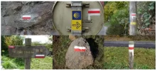
The GR marking system, or
balises in French, has three types of marks:
1) White bar over red bar: This is a GR route. Could be any route number. Pay particular attention where GR routes intersect, such as where the GR 6 comes in at Aubrac (or thereabouts).
2) White bar over red bar plus a directional arrow right or left: Turn coming up in the indicated direction. We will only notify you this once, so pay attention.
3) X formed by a red diagonal crossing a white diagonal: This ain't it, buddy.
So the process goes like this for every intersection:
Situation A
1) Route marking (about every km or so, more frequently in towns)
2) Turn coming up
3) Find the X - not that way. Find another X - not that way either. So it must be down here.
4) Route marking - yes, you chose the right exit from the intersection.
OR
Situation B:
1) Route marking
2) Intersection with no turn indicated - go straight through
3) Route marking
If you are not careful, and do not notice the "turn upcoming" mark, you will mistake Situation A for Situation B. It pays to watch the schematic map in
Miam Miam Dodo.
Marking frequency is less than in Spain but much more than in German-speaking areas. Marks can by on rocks, trees, fenceposts, utility poles, reverse side of highway signs, houses, buildings, etc. There will be other, regional or local routes that use the same shapes but different colors.


