Search 74,075 Camino Questions

Portuguese Camino do Norte

Clark

Member
Time of past OR future Camino
Planning to hike the Portuguese Way from Porto to Santiago in May 2018
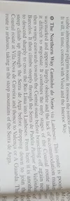
In his guide, Brierley writes of a difficult mountainous Portuguese route known as the Camino do Norte. He doesn't give any indications of it's location or if it's currently way marked in the book, aside from pointing out a few mountain peaks that it crosses.

Does anyone know if this route is still in use or where it's actually located? I can't find any information about it online or on any Camino map.
 
Get a spanish phone number with Airalo. eSim, so no physical SIM card. Easy to use app to add more funds if needed.
Perhaps the Camino Torres?
A seldom traveled path from Salamanca to Braga. It is the only one that comes to mind as being mountainous. Can you provide any more info?
 
Join the Camino cleanup. Logroño to Burgos May 2025 & Astorga to OCebreiro in June
Perhaps the Camino Torres?
A seldom traveled path from Salamanca to Braga. It is the only one that comes to mind as being mountainous. Can you provide any more info?
Here is the image from Brierley:
 

Attachments

  • 20171226_113551.webp
    20171226_113551.webp
    195.5 KB · Views: 67
His site is a great source of information, you will find old maps on there as well as new, it's worth scouting around on his website the maps that link gives some are dated 2008, I have seen 2015 maps elsewhere on his site.
There is accommodation for the route, I cannot be specific I have just been keeping on a eye for a little time now and know that two places have municipal albergue built partly for this route and groups on activity holidays, an albergue De Peregrino after you cross the river into Spain, which is a destination itself for pilgrims and Luis Frexio himself the composer of the caminador website has a refugio for pilgrims on a detour of about 4 km from this route.
 
...and ship it to Santiago for storage. You pick it up once in Santiago. Service offered by Casa Ivar (we use DHL for transportation).
You can find gps for this caminho "
I found a link to a Camino Senhora do Norte (Barcelos to Vigo via Lanheses) on Luis Freixo's website: http://www.caminador.es/?page_id=1982
I found these gps tracks for the portion Barcelos to Lima River.
https://pt.wikiloc.com/trilhas-trek...o-do-norte-senhora-do-norte-1a-etapa-11466915
https://pt.wikiloc.com/trilhas-trek...o-do-norte-senhora-do-norte-2a-etapa-11720448

I have spotted many yellow arrows in places I do not recognize as one of the main caminos. I'm sure there may be some on this one.
There may be some indications, but if you want to follow this route its best to have a good map and gps.

This camino is between Central and the Coastal. Knowing some of the terrain, it would be more challenging then either, due to the topography distance from villages.
 
In his guide, Brierley writes of a difficult mountainous Portuguese route known as the Camino do Norte. He doesn't give any indications of it's location or if it's currently way marked in the book, aside from pointing out a few mountain peaks that it crosses.

Does anyone know if this route is still in use or where it's actually located? I can't find any information about it online or on any Camino map.


I am very interested in hiking this route. Did you take this route on your Camino?
 

❓How to ask a question

How to post a new question on the Camino Forum.

Featured threads

❓How to ask a question

How to post a new question on the Camino Forum.

Featured threads

Forum Rules

Forum Rules

Camino Updates on YouTube

Camino Conversations

Most downloaded Resources

This site is run by Ivar at

in Santiago de Compostela.
This site participates in the Amazon Affiliate program, designed to provide a means for Ivar to earn fees by linking to Amazon
Official Camino Passport (Credential) | 2024 Camino Guides
Back
Back
Top