• ⚠️ Emergency contact in Spain - Dial 112 and AlertCops app. More on this here.
  • Remove ads on the forum by becoming a donating member. More here.

Search 74,075 Camino Questions

Pontedeume to Miño - Via the Coast

Dave

Veteran Member
Time of past OR future Camino
First: Camino Francés 2002; most recent: Norte/Primitivo 2019
One of my frustrations with the Inglés is that, once you’ve passed Neda, your coastal time is all but gone. Sure, you can see it from the hills for a while, and we could quibble over Pontedeume and the aftermath of Miño, but despite it being right there, you’re not on it. The re-routing away from Cabanas stuck in my craw for that reason, as you’re bypassing what had been the best beach on the Inglés. It also blew my mind when I looked up Miño after my first time on the Inglés and discovered the huge, glorious beach to the west of where the camino passes through town. Again, it’s right there! (My fault for not doing my homework!)

So, I’ve been hunting around for ways to fix this (for my personal edification, at least)—or at least to better understand why the route exists as it does. And I can see now that a more coastal approach between Neda and Fene is impractical because of port business and train tracks, and Fene to Pontedeume would involve such a significant distance increase that I ruled it out as impractical. Miño to Betanzos is a maybe, but complicated because of the train, at least in the first third/half (I might try it someday). But… Pontedeume to Miño? Now, that looked interesting! So, I mapped out a plan and then followed it two days ago.

And it was pretty darn good! It’s a bit longer than the official route (12.8km total, or 2.7km longer), but that’s not horrible. Here’s what you get for that: a nice footpath through trees along the coastline, three different beaches (two of which you can definitely walk on and a third you should be able to eventually), two solid churches, and nearly non-stop coastal views. Here’s a map--the route I'm describing is in green, the official approach is in red (and that western spur of the official is a detour to Breamo).
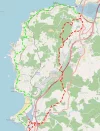
1546367052809.webp

Here’s some more detail: leaving Pontedeume, head to the train station, which is north of town. (Did I mention that this bypasses the entire climb out of Pontedeume?) Walk to the end of the station, cross the tracks, and join a trail running parallel to the tracks. This will periodically swing wide out to the coast and then veer back to the tracks. It eventually brings you to the Church of Centroña (2.3km), where you’ll pass in through the back, leave out the front gate and then arrive at a complicated intersection. Don’t pass under the railroad. Don’t follow the dirt road downhill towards the coast. Instead, follow the footpath climbing up alongside the railroad. A little while later, continue straight on a paved road. When that road turns left under the highway (900m), you have the diciest proposition of this walk, navigating a… let’s call it a footpath, up the hill straight in front of you, gradually looping to the right so that you wrap around the outside of the house, ultimately arriving at a minor highway. This worked fine for me, but it might be worse in spring/summer. You could also just follow the road as it winds around and joins the highway eventually—probably burning an extra half-km in the process.

Anyway, you’re on the DP-4803 now (turn right!). There’s no sidewalk here and minimal shoulder, but I only had 10 cars pass me and none in both lanes at the same time, so it didn’t feel unsafe. 800m later, shortly after passing a bar (for sale and closed at this time), turn right onto a footpath. It’s a good, established, obvious path, just before the road curves left. After a short descent, turn left on a beaten old asphalt road. Continue straight on this, ignoring cross streets, into the small beach town of Ber. Most everything seems out of business, though there is a bar still operating in the parking lot by the beach. Even the beach was closed when I was there! Seems like they’re maybe repairing the access steps. Not sure. My hope had been to descend to the beach and then follow a footpath up from the southern corner. Instead, I followed a road south from town, cutting hard back toward the coast on another small road. Worked just fine. Ber is 4.6km from Pontedeume.

700m later, fork left off the road onto a dirt track, just before a house. You’ll follow it uphill past two fields before it finally curves right, just along a hilltop. A short time later, it arrives at a T on a paved road. Turn left, then take the next right. When you arrive at the Igrexa de Santiago de Boebre, turn right again. This road curves a lot, but you’re sticking with it as it leads you along a stretch near the waterfront before ultimately arriving at the DP-4803 again (now with sidewalks!). You’re 7.2km from Pontedeume now.

Turn right on the DP-4803, but just for 200m, as it curves left. Soon after the road straightens back out, turn right downhill to the beach. This is the excellent Praia de Perbes. You’re going to walk the full length of the thing. It’s great. At the end of the beach, look for the trail kicked into the place where the tiny peninsula juts out from the coast. The first few steps are a little tricky, but climb over, curve left and then descend to the much smaller neighboring beach. Around the middle of that beach, you’ll find wooden steps leading to a track that brings you back to the highway. (Don’t go to the steps at the end of the beach; they lead to a locked gate!) Once on the highway, you’re 8.4km from Pontedeume.

You’re stuck on the highway for the next 2.4km, but there’s a sidewalk and the views are almost unfailingly great, especially as you approach Miño. Very soon after crossing the bridge to Miño, you can once again cross to walk along the beach (did I mention it’s huge?), or follow a wooden boardwalk parallel to the highway. This runs for a full kilometer. At the end of the beach, rejoin the highway as it curves inland, for a final km into the center of town (and to rejoin the Inglés).

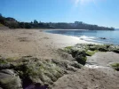
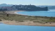
I'll end with a few pics:

The trail near Pontedeume
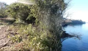
1546367399422.webp

The Praia de Perbes
1546367212383.webp

Miño Beach
1546367465645.webp
 
...and ship it to Santiago for storage. You pick it up once in Santiago. Service offered by Casa Ivar (we use DHL for transportation).
Wow! This is great!! Thank you for the map and the details!!
 
Hopefully you will include this in the guide as an unofficial/personal alternative.
We must have been among the last to walk the old route into Pontedeume and actually stayed at the hotel facing the beach in Cabañas, ate in one of the beach cafes.
An alternative to the new route sounds good, even if it is after Pontedeume rather than before, and especially if it avoids that hill. The one from Casa Julia was preferable :)
 
Get a spanish phone number with Airalo. eSim, so no physical SIM card. Easy to use app to add more funds if needed.
That's the goal! We have a lot of bits and pieces to pack in over the next week as we muddle through the last shot at revisions. Hoping this doesn't cause too much trouble...
 
both the old and new Ingles routes ignored Mino, and I agree, it has the most wonderful white sand beach. The only way to really enjoy Mino is to break the Pontedeume to Betanzos stage and stay in Mino overnight. Mino has an albergue and pensions.

Otherwise, what you do is walk along the main street at Mino where the pizza restaurants are, go down to Mino station and you are completely oblivious as to how near you are to the sea.

However, your coastal route from Pontedeume to Mino is well worth looking at. Firstly it is more scenic than the official Ingles route, and secondly, it removes climbing the brute of the hill out of Pontedeume !!!!! This hill is such a killer that they purposefully put a seat halfway up for you to rest and recuperate


By mistake, I did walk the old route from Vilar do colo to Pontedeume, instead of the new route. You don't go under the motorway bridge, but turn right on the first roundabout once you have passed Vilar do colo. You fork right about 50 metres along the road from the roundabout and then walk beside a field and when you come out the other end, onto a street, there are then yellow arrows still on the telegraph poles that walk you all the way down the hill to Cabanas and you walk the whole of the white sand beach to come out by the bridge at Pontedeume.
 
Very interesting to read about these detours. The Miño beach is great. We stayed in the Miño albergue. We were the only ones by then in may 2014. The lock of the frontdoor was broken so we barricated the door with chairs and buckets so if opened we could hear the noice .

One desadvantage on changing the route.
Further on we decided to stay in a hotel in Ordes.so we went off camino ,about 2 kms. Just before arriving at the hotel there was a church where I asked for stamps on our credentials.the priest in charge refused because he said that Ordes is not on the camino. And as you know you'll need 2 stamps a day for the last 100 kms to Santiago
 
Get a spanish phone number with Airalo. eSim, so no physical SIM card. Easy to use app to add more funds if needed.
That's the goal! We have a lot of bits and pieces to pack in over the next week as we muddle through the last shot at revisions. Hoping this doesn't cause too much trouble...

Are there any arrows Dave ?
or
Any signs indicating the Camino route,
We have been lost before , especially from Mont St Michel and actually loved it because of the people we met and who directed us.

Just don't want to keep looking at your above description,

We are not there until early July so others might be using as well.
No problems either way , just saving these old 72 yr knees the agony of the hill.
 
Are there any arrows Dave ?
or
Any signs indicating the Camino route,

No arrows, no markers! It's definitely not "official" camino or even any sort of pseudo-official alternative. But it's a great walk!

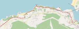
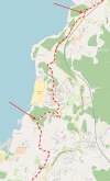
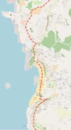
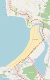
To help simplify things for you, I've made a more zoomed-in version of the map, with arrows marking the two turns that I think are easiest to miss--first when you have to ascend the hill to a minor highway and the second, after Ber, when you have to fork off a road onto a minor track. Beyond those, I think you'll find the walk pretty manageable with the maps.

Hope you enjoy it!
 

Attachments

  • map1.webp
    map1.webp
    77.1 KB · Views: 59
  • map2.webp
    map2.webp
    91.9 KB · Views: 51
  • map3.webp
    map3.webp
    93.1 KB · Views: 47
  • map4.webp
    map4.webp
    104.3 KB · Views: 46
AWESOME! Thanks so much @Dave because you've just made the Inglés much more appealing to me. Looking forward to getting your new guide! 👍
 
...and ship it to Santiago for storage. You pick it up once in Santiago. Service offered by Casa Ivar (we use DHL for transportation).
One of my frustrations with the Inglés is that, once you’ve passed Neda, your coastal time is all but gone. Sure, you can see it from the hills for a while, and we could quibble over Pontedeume and the aftermath of Miño, but despite it being right there, you’re not on it. The re-routing away from Cabanas stuck in my craw for that reason, as you’re bypassing what had been the best beach on the Inglés. It also blew my mind when I looked up Miño after my first time on the Inglés and discovered the huge, glorious beach to the west of where the camino passes through town. Again, it’s right there! (My fault for not doing my homework!)

So, I’ve been hunting around for ways to fix this (for my personal edification, at least)—or at least to better understand why the route exists as it does. And I can see now that a more coastal approach between Neda and Fene is impractical because of port business and train tracks, and Fene to Pontedeume would involve such a significant distance increase that I ruled it out as impractical. Miño to Betanzos is a maybe, but complicated because of the train, at least in the first third/half (I might try it someday). But… Pontedeume to Miño? Now, that looked interesting! So, I mapped out a plan and then followed it two days ago.

And it was pretty darn good! It’s a bit longer than the official route (12.8km total, or 2.7km longer), but that’s not horrible. Here’s what you get for that: a nice footpath through trees along the coastline, three different beaches (two of which you can definitely walk on and a third you should be able to eventually), two solid churches, and nearly non-stop coastal views. Here’s a map--the route I'm describing is in green, the official approach is in red (and that western spur of the official is a detour to Breamo).

View attachment 50322

Here’s some more detail: leaving Pontedeume, head to the train station, which is north of town. (Did I mention that this bypasses the entire climb out of Pontedeume?) Walk to the end of the station, cross the tracks, and join a trail running parallel to the tracks. This will periodically swing wide out to the coast and then veer back to the tracks. It eventually brings you to the Church of Centroña (2.3km), where you’ll pass in through the back, leave out the front gate and then arrive at a complicated intersection. Don’t pass under the railroad. Don’t follow the dirt road downhill towards the coast. Instead, follow the footpath climbing up alongside the railroad. A little while later, continue straight on a paved road. When that road turns left under the highway (900m), you have the diciest proposition of this walk, navigating a… let’s call it a footpath, up the hill straight in front of you, gradually looping to the right so that you wrap around the outside of the house, ultimately arriving at a minor highway. This worked fine for me, but it might be worse in spring/summer. You could also just follow the road as it winds around and joins the highway eventually—probably burning an extra half-km in the process.

Anyway, you’re on the DP-4803 now (turn right!). There’s no sidewalk here and minimal shoulder, but I only had 10 cars pass me and none in both lanes at the same time, so it didn’t feel unsafe. 800m later, shortly after passing a bar (for sale and closed at this time), turn right onto a footpath. It’s a good, established, obvious path, just before the road curves left. After a short descent, turn left on a beaten old asphalt road. Continue straight on this, ignoring cross streets, into the small beach town of Ber. Most everything seems out of business, though there is a bar still operating in the parking lot by the beach. Even the beach was closed when I was there! Seems like they’re maybe repairing the access steps. Not sure. My hope had been to descend to the beach and then follow a footpath up from the southern corner. Instead, I followed a road south from town, cutting hard back toward the coast on another small road. Worked just fine. Ber is 4.6km from Pontedeume.

700m later, fork left off the road onto a dirt track, just before a house. You’ll follow it uphill past two fields before it finally curves right, just along a hilltop. A short time later, it arrives at a T on a paved road. Turn left, then take the next right. When you arrive at the Igrexa de Santiago de Boebre, turn right again. This road curves a lot, but you’re sticking with it as it leads you along a stretch near the waterfront before ultimately arriving at the DP-4803 again (now with sidewalks!). You’re 7.2km from Pontedeume now.

Turn right on the DP-4803, but just for 200m, as it curves left. Soon after the road straightens back out, turn right downhill to the beach. This is the excellent Praia de Perbes. You’re going to walk the full length of the thing. It’s great. At the end of the beach, look for the trail kicked into the place where the tiny peninsula juts out from the coast. The first few steps are a little tricky, but climb over, curve left and then descend to the much smaller neighboring beach. Around the middle of that beach, you’ll find wooden steps leading to a track that brings you back to the highway. (Don’t go to the steps at the end of the beach; they lead to a locked gate!) Once on the highway, you’re 8.4km from Pontedeume.

You’re stuck on the highway for the next 2.4km, but there’s a sidewalk and the views are almost unfailingly great, especially as you approach Miño. Very soon after crossing the bridge to Miño, you can once again cross to walk along the beach (did I mention it’s huge?), or follow a wooden boardwalk parallel to the highway. This runs for a full kilometer. At the end of the beach, rejoin the highway as it curves inland, for a final km into the center of town (and to rejoin the Inglés).

I'll end with a few pics:

The trail near Pontedeume
View attachment 50325

The Praia de Perbes
View attachment 50323

Miño Beach
View attachment 50326
Thanks Dave! I'm planning to do this tomorrow. I am very challenged by map reading (and steep ascents & descents) so I'm impressed with your detailed instructions! Super keen to avoid that steep climb out of Pontedeume and much prefer a coastal walk. 😉
 
A very interesting alternative indeed. Thank-you. I have walked the Inglés twice, and did NOT miss the beach in Miño the second time around because we were several of the very few to stay in the albergue there. But I did miss the beach coming into Pontedume. Was disappointed in that change. I will keep this alternative in mind if/when I do it again! It is a short challenging walk and without the hill after Pontedeume would make it a lot easier. Plus I am indeed a beach nut.
 
Thanks Dave! I'm planning to do this tomorrow. I am very challenged by map reading (and steep ascents & descents) so I'm impressed with your detailed instructions! Super keen to avoid that steep climb out of Pontedeume and much prefer a coastal walk. 😉

Hope you enjoy it! Let me know how it goes for you.
 
The one from Galicia (the round) and the one from Castilla & Leon. Individually numbered and made by the same people that make the ones you see on your walk.
Nice alternative! Thanks :)
I just walked the Inglés (07-12/06) and the climb is not that difficult if I may add ;)
Will be a nice alternative if I walk the Inglés again.
Keep up the good work.
 
Dave, I’m intrigued, I’ll be on the Ingles in August. What guide are you publishing?
 
Get a spanish phone number with Airalo. eSim, so no physical SIM card. Easy to use app to add more funds if needed.
Hello All,
My son and I just attempted this route today, we stopped at Playa Perbes. In Dave's first description of the route where he mentions it might be bad in spring/summer, he was correct it is very bad I am covered in thorn scratches. When climbing up onto the road by the house (you will need to read his description to understand mine) my son was able to because he is just about 2 meters tall, I chose to walk to the house finding the owner there, he was quite surprised to see me but very nice. I have a feeling this area of the path, though today there really wasn't a path after a few meters, on Dave's map is private property I would recommend the road, however I don't know how that would work since we didn't go that way.
My son and I walk to help his anxiety and this walk was causing him some intense anxiety so we stopped short at the beach in Perbes, however from reading Dave's description and looking at the map I think the rest of the way would have been straight forward from Perbes to Miño.
My thoughts overall, I understand those of us that look for new ways especially the 2nd, 3rd....time around, we live in A Coruña so we have spent time on the inglés. My son and I both agree that the stage from Pontedeume to Betanzos is one of the best stages on the inglés, so I would not choose this coastal way for my first time, and honestly I doubt I will walk it again, glad to have made the attempt though.I agree with Peb that the easiest way to enjoy Miño would be to stay there.
Dave, thanks for giving us an adventure this Saturday morning!! As an aside I was born and raised in Portland.
Buen Camino
MaryEllen
 
Thanks for the update, MaryEllen. I'm sorry if this caused your son any trouble! The easy work-around for this is to follow the road, mentioned above, but I think there's still a track of some sort around that hill that I must not have fully uncovered. I'll need to revisit this in the summer, when everything is in full bloom--possible trails seem much more evident in the dead of winter! Definitely don't want to antagonize the home owner.

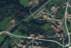
Here's a closer look at the map of this section:

59649

So, instead of following the dashed red line from the top-middle to the bottom-left of that image, it's possible to follow the road under the train tracks and then loop back around to the CP-4803. A little longer, but no thorns and no harm done.

Incidentally, Open Street Map indicates that a road exists, linking where the road ends with the red-dashed line and the small road in front of the home in the center-left. There is definitely no road...
 
Don't worry we had a good time over all, important life lessons.
Great map!! you were spot on about it being tough in spring/summer. The owner of the house was super nice just surprised to see me. Pilgrims that can get up to the road he wouldn't see, it will be interesting for him if more start to go by. Maybe you should say hello the next time you pass by, he recommended going up through the houses to a road that had great views but we wanted to follow our set course.
Thanks again for sharing this route for all.
MaryEllen
 
Get a spanish phone number with Airalo. eSim, so no physical SIM card. Easy to use app to add more funds if needed.

❓How to ask a question

How to post a new question on the Camino Forum.

Most read last week in this forum

Due to a late arriving flight I'm planning on getting the early train from A Coruña to Ferrol which arrives just before 8am. Tourist office will be closed. Ideas please on where to get a first...
Hey everybody, I was wondering if it was possible to walk from A Coruna to Ferrol as a way of extending the Camino Ingles. Also, if it’s possible, how best it can be achieved, so walking stages...

Featured threads

❓How to ask a question

How to post a new question on the Camino Forum.

Featured threads

Forum Rules

Forum Rules

Camino Updates on YouTube

Camino Conversations

Most downloaded Resources

This site is run by Ivar at

in Santiago de Compostela.
This site participates in the Amazon Affiliate program, designed to provide a means for Ivar to earn fees by linking to Amazon
Official Camino Passport (Credential) | 2024 Camino Guides
Back
Top