• Remove ads on the forum by becoming a donating member. More here.

Search 74,075 Camino Questions

Pilgrim rescued near Valcarlos.

Status
Not open for further replies.

wayfarer

Veteran Member
Time of past OR future Camino
2012, 2013, 2014.
€2,-/day will present your project to thousands of visitors each day. All interested in the Camino de Santiago.
"After being taken to the Valcarlos health center, where it has been verified that the pilgrim was in good condition, he has been taken to the Roncesvalles hostel..."

Well done all...
Rescue services are worth their weight in gold and then some and any I have worked with never judge why you got in trouble, they just make sure you are safe.
 
Holoholo automatically captures your footpaths, places, photos, and journals.
I had no idea it could be that dangerous in the Valcarlos, just found out the Route Napoleón is closed until March 31 because a lot of pilgrims end up stranded or dying during winter making the trip.

God bless the rescue workers.
Closed till the 1st of April and depending on weather conditions it could run later. Always check with the pilgrim office in SJPdP, they will let you know what conditions are like. They told us not to walk it around 19th April one year because of snow and wind, some choose to walk it anyway and were lucky to make it through. This was before the compulsory closures.
 
Last edited:
Get a spanish phone number with Airalo. eSim, so no physical SIM card. Easy to use app to add more funds if needed.
It is always sad to see when people need to be rescued. I am always curious as to how the people get lost (the circumstances) - in this incidence, was the snow covering the trail and/or the signage? Or did he miss some signage? Or was there poor signage in that particular area?

And I wish I knew what they meant - he had coverage but didn't have mobile internet. Does that mean he was out of range or did he pay for cellular and not data? That piece is unclear to me. Did he call for help because he knew he was lost? Or did someone realize he was missing and sent out a search party. So many questions the article doesn't answer

Anyhow - getting lost or getting injuries are definitely an argument for carrying a cell phone with service coverage in Spain - but the limited details on the article don't help me understand if his phone was/was not working adequately in the location. Also - it would appear he didn't have any downloaded maps in case he got lost when he was out of cellular data range.

Anyhow - not asking these questions to be critical of the person, but more as I want to learn from his experience. I would like to think carrying a cell phone, with cellular and data coverage in Spain, and having a downloaded map of the route for offline GPS use would prevent a situation like this - but that isn't always the case. On the Frances/Norte/Primitivo - most of the time I had great cell/data service - but doing the VF this summer and I am concerned in some areas this may be a problem. But at least I won't be going in the Winter months.
 
And I wish I knew what they meant - he had coverage but didn't have mobile internet. Does that mean he was out of range or did he pay for cellular and not data? That piece is unclear to me. Did he call for help because he knew he was lost?
The article says that the man himself called for help and reported that he was lost. He was unable to give his exact location and what he could describe of the area was ambiguous. So search teams were sent to several possible locations. Given heavy snow on the ground it is quite possible that he was unable to see yellow arrows or other markers and wandered off the path. The Valcarlos route is much less travelled than the Route Napoleon and signage is less frequent.
 
Holoholo automatically captures your footpaths, places, photos, and journals.
This is really helpful reading as I am about to do the Route Napoleon on the 1st April, I will touch base before attempting it.
We are planning to leave SJPP on April 1, hoping to follow the Napoleon route - but prepared to make other plans if the weather is not good. Hopefully we can get to Borda, we have booked for the first night, and then make a decision. The owner of Auberge Borda has suggested a taxi to Valcarlos would be possible if the high route was closed.
 
I had no idea it could be that dangerous in the Valcarlos, just found out the Route Napoleón is closed until March 31 because a lot of pilgrims end up stranded or dying during winter making the trip.

God bless the rescue workers.
Hola @santiago, A little investigation will reveal that it can snow in the Pyrenees at almost any time of the year. All it takes is a small Atlantic storm to arrive and there you have the weather that is commented upon often. The experienced pilgrims will tell you that you should always "be prepared" when walking either of the routes from St Jean to Roncesvalles. Cheer
 
Get a spanish phone number with Airalo. eSim, so no physical SIM card. Easy to use app to add more funds if needed.
We are planning to leave SJPP on April 1, hoping to follow the Napoleon route - but prepared to make other plans if the weather is not good. Hopefully we can get to Borda, we have booked for the first night, and then make a decision. The owner of Auberge Borda has suggested a taxi to Valcarlos would be possible if the high route was closed.
Hola - given that it is still snowing down to 1500 metres (or lower) (4500ft) being prepared to change your plans is the sign of the wise pilgrim. Back in May 2017 I too had hoped to trek the Napoleonic route, but high winds, snow,sleet and temperatures down to 5C (40F) meant it was just too risky. I ran into a woman who was "blown over" by a 80km/h wind gust, ended up spending a night in hospital. Buen Camino.
 
Hola! gracias. We are prepared to make changes, but really hoping the Napoleon will be open
 
The hype around the Napoleon route is perhaps partly built on misperception: in discussions of the way from SJPP, statements like 'treking over the Pyrenees' are ubiquitous but very misleading These are merely foothills, not at all like the more dramatic Haute Pyrenees further East. It's a big hill to be sure, but hardly an intense mountain climbing expedition.

Even so, this walk is not ever to be taken lightly, whether over the top or via Valcarlos. Mountains are unforgiving, even small hilly ones.

getting lost or getting injuries are definitely an argument for carrying a cell phone with service coverage in Spain - but the limited details on the article don't help me understand if his phone was/was not working adequately in the location. Also - it would appear he didn't have any downloaded maps in case he got lost when he was out of cellular data range.
There is no need for internet to get one's location data or to use a map app - location is satellite-based. Perhaps the person was not familiar with the technology, or did not have a decent off-line map, or was in a place where the signal was blocked, or maybe it was just that their battery was low. Or all of the above. We will never know.

But it's a cautionary tale. If you carry a phone, install an off-line map (I use OSMand and like it a lot), make sure you have battery power (and an external means of recharging), and (essential!) know how to use all of that ahead of time.
 
Ideal sleeping bag liner whether we want to add a thermal plus to our bag, or if we want to use it alone to sleep in shelters or hostels. Thanks to its mummy shape, it adapts perfectly to our body.

€46,-
But it's a cautionary tale. If you carry a phone, install an off-line map (I use OSMand and like it a lot), make sure you have battery power (and an external means of recharging), and (essential!) know how to use all of that ahead of time.
You're right. All the tech isn't much use if you don't know how to use it!
 
But it's a cautionary tale. If you carry a phone, install an off-line map (I use OSMand and like it a lot), make sure you have battery power (and an external means of recharging), and (essential!) know how to use all of that ahead of time.
Anyhow - getting lost or getting injuries are definitely an argument for carrying a cell phone with service coverage in Spain - but the limited details on the article don't help me understand if his phone was/was not working adequately in the location. Also - it would appear he didn't have any downloaded maps in case he got lost when he was out of cellular data range.
It is entirely possible that he was not carrying a smartphone, which would provide a complete explanation for the reporting that he was able to contact the emergency services but not able to provide them his location.
 
It is entirely possible that he was not carrying a smartphone, which would provide a complete explanation for the reporting that he was able to contact the emergency services but not able to provide them his location.
Yes, very true. Funny not to be thinking of that.
 
The focus is on reducing the risk of failure through being well prepared. 2nd ed.
But it's a cautionary tale. If you carry a phone, install an off-line map (I use OSMand and like it a lot), make sure you have battery power (and an external means of recharging), and (essential!) know how to use all of that ahead of time.
I have an app installed call GPS Coordinates that can show maps but since I have better apps for that I have GPS Coordinates set to just display my current latitude and longitude coordinates making it easy to give someone my location. You can use this app even if you know nothing about maps or how to get coordinates from a map app. You can also use it to share your location by email in which case it also includes a link to Google Maps that shows your location on that app.
 
You can use this app even if you know nothing about maps or how to get coordinates from a map app
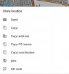
Fortunately for us all it's actually not rocket science. With OSMand on my Android it's super easy. Press your index finger on your location, then press share and this menu pops up with a bunch of options.
20230314_213419.jpg
Don't know from experience about Apple but I bet it's similarly easy.
 
It is entirely possible that he was not carrying a smartphone, which would provide a complete explanation for the reporting that he was able to contact the emergency services but not able to provide them his location.
Very true. And like I said - would be nice to know more details in situation like this. Great opportunities to learn so future incidents "might" be more preventable.
 
The 2024 Camino guides will be coming out little by little. Here is a collection of the ones that are out so far.
As a whole the Camino, especially the Frances, is quite safe and a pilgrim has to work very hard to put themselves in danger. Although 99.99% of pilgrims carry them one doesn't have to have a cellphone with internet to know the weather the next day (ask the pilgrim's office) and even though the Napoleon route is closed and the Valcarlos is the alternative, if the weather reports show extreme conditions the next day one should rethink their plans. It's just not worth it.
 
I have an app installed call GPS Coordinates that can show maps but since I have better apps for that I have GPS Coordinates set to just display my current latitude and longitude coordinates making it easy to give someone my location. You can use this app even if you know nothing about maps or how to get coordinates from a map app. You can also use it to share your location by email in which case it also includes a link to Google Maps that shows your location on that app.
Hi Rick - I have an app "what three words" - virtually all the land mass of the world in divided up into 15m squares. Where ever you are if you click on the app up will come (in English - for me) a unique three word combo that First Responders can reverse input and track you to your present location. Cheers
 
Responders can reverse input and track you to your present location
What three words (WTW) is an excellent concept, and I have it on my smartphone. Have you checked recently that the emergency services in Spain can decode WTW locations? I expect that they will have had time to implement the tools needed to do this, but I haven't checked. I know it was a big thing locally when the SES did get around to doing that.

To be clear, WTW won't allow responders to track you unless you are continually sending them updates. It relies on you staying where you are at the time that you contacted the emergency services.

An app that I use is Emergency Plus in Australia - that gives both lat/long and WTW. It is not limited to Australia and works overseas for location. The Emergency contact information is Australia specific. For country specific functionality I would recommend AlertCOPS if one is in Spain.
 
Last edited:
€2,-/day will present your project to thousands of visitors each day. All interested in the Camino de Santiago.
Good time to plug the "what3words" app. Free download for any platform as far as I know. Every coordinate point for every corner of every 3 meter square on the planet has 3 words assigned to it. Geolocation via GPS translates your location into 3 words that you can provide to rescue teams. Rescue teams put the 3 words in at their end and receive your coordinates down to the square meter that you are in.
 
Hi Rick - I have an app "what three words" - virtually all the land mass of the world in divided up into 15m squares. Where ever you are if you click on the app up will come (in English - for me) a unique three word combo that First Responders can reverse input and track you to your present location. Cheers
I don’t think this app is familiar to the Spanish emergency rescue services. I think the best thing to do to be prepared for an emergency is to make sure you can convey your location coordinates. It’s very easy to do via WhatsApp, and the Spanish 112 uses WhatsApp.
 
I don’t think this app is familiar to the Spanish emergency rescue services. I think the best thing to do to be prepared for an emergency is to make sure you can convey your location coordinates. It’s very easy to do via WhatsApp, and the Spanish 112 uses WhatsApp.
@peregrina2000, I have contacted the company that owns what3words and asked about by its use by emergency services in Spain and Portugal. I will pass on their response once I get one.
 
The focus is on reducing the risk of failure through being well prepared. 2nd ed.
@peregrina2000, I have contacted the company that owns what3words and asked about by its use by emergency services in Spain and Portugal. I will pass on their response once I get one.
I have a response from what3words. To quote: '... the emergency services in Spain and Portugal aren't using us yet, this page explains in details the emergency services that do use what3words and in which countries.'

Deployment of what3words seems to vary by country and region - implementation isn't universal in the countries where it is being deployed. You can follow the link provided in the company's response to see where it has been deployed.
 
Last edited:
Hi Rick - I have an app "what three words" - virtually all the land mass of the world in divided up into 15m squares. Where ever you are if you click on the app up will come (in English - for me) a unique three word combo that First Responders can reverse input and track you to your present location. Cheers
I have had the What3Words app on my phone for years and I've recommended OSMand on the forum. But I want something simple that doesn't require much special knowledge on either end of the rescue. I am assuming that latitude and longitude coordinates are known by emergency services.

Here's a worst case scenario. I'm with a tech luddite off trail bird watching in a wilderness area with no phone, data or wifi service available but there is a ranger station where we parked the car. A tree falls on me and I'm going to pass out. The rangers may not know about What3Words and I'd be dead before the luddite could figure out OSMand. I could probably get away with saying "Hey bud, open the GPS Coordinates app on my phone, take a screenshot and display it. Give the phone to Lassie and send her for help."

On opening the app you see something like this:
Screenshot_20230314-114704-01.jpeg

BTW Mike, I tested W3W with Airplane Mode on to simulate no service available and got nothing.

Also, in Spain another emergency app to install is AlertCops. But it requires a connection. I want an app that can work mid-Atlantic to get my location so I can send out a radio Mayday distress call from a sinking boat.
 
Last edited:
The one from Galicia (the round) and the one from Castilla & Leon. Individually numbered and made by the same people that make the ones you see on your walk.
Here's a worst case scenario. I'm with a tech luddite off trail bird watching in a wilderness area with no phone, data or wifi service available but there is a ranger station where we parked the car. A tree falls on me and I'm going to pass out. The rangers may not know about What3Words and I'd be dead before the luddite could figure out OSMand. I could probably get away with saying "Hey bud, open the GPS Coordinates app on my phone, take a screenshot and display it. Give the phone to Lassie and send her for help."
So not quite the circumstances one might expect on the camino! This appears to go to some basic bush-walking planning and preparation:
  • Did you file a trip intention/plan with a trusted person or at the ranger station, and did you stick to it?
  • Knowing that you were going to be in an area without mobile phone reception, did you carry a PLB, and why not? Where I live, one can borrow/rent a PLB from the national park service for exactly these circumstances should you not own one yourself.
  • Did you think to carry a paper map and compass, and have you been following your route and sharing that information with your companion? You should have considered doing this as soon as you contemplated going off-trail. You really shouldn't be relying on a smartphone, not matter how good the mapping is, in these circumstances.
  • Why were you walking with just one companion? As a general rule, there should have been at least three in these circumstances - one to go for help and one to stay with an injured person.
If you haven't done any of this, it's not so much that you deserve to die, but your lack of preparation will see you quickly in real danger of doing so.

There is no Lassie to go back. At least in Australia, dogs are banned in national parks, and Lassie was left at home with your family. If you weren't in a national park you left her at home anyway, because she always disrupts your bird-watching by her excited behaviour whenever you spot something interesting.​
Your non-tech friend will get lost returning to the ranger station because they have no map and cannot use your GPS app. They will spend a couple of nights in the bush without food or shelter until the rangers ponder over why your car hasn't moved, at which point they have no idea they are looking for two people in separate locations.​
They will be hampered by not knowing you have been injured, but they might assume that one of you has been.​
There might need to be some checking with your family, etc to confirm that you are at risk before activating a search for you, when they will find they are looking for two people, but they won't know whether or not you have separated.​
If conditions are suitable, they might start looking for you the day the alert is raised, but it might not be until the following day that a full scale search can begin, and you will have spent a third night injured, exposed and cold, having consumed any food your friend left handy as you faded in and out of consciousness.​
You might begin to suffer hypothermia, reaching the point where you feel so hot that you strip off what clothes you can, glad that the cold that you were feeling last night has gone. You need to be found very quickly to survive, because you are now so close to death.​
So I think your friend not knowing how to read a lat/long is probably the least of your problems in this case.

ps your friend survives, but suffers PTSD and never goes bushwalking again. The search for you continues for a another day before they find and recover your body.
 
Last edited:
...and ship it to Santiago for storage. You pick it up once in Santiago. Service offered by Casa Ivar (we use DHL for transportation).
So not quite the circumstances one might expect on the camino!
Same with the boat. Bud drank all the vodka and played with the sextants and dropped them overboard. Angry at Bud I shot him repeatedly with the flare gun. Lassie peed on the GPS receiver and shorted it out. I threw her overboard after she chewed up the life raft. Turns out the radio was a receiver only. I used GPS Coordinates to get my position, wrote them down on paper and inserted the paper into an empty vodka bottle that Bud emptied. It's all up to the Burgette bomberos now.
 
Last edited:
I strongly recommend installing a Spanish app called "AlertCops" on your phone. It has been developed by the Spanish authorities for exactly the distress situations pilgrims (and others) may end up in.

It is essential not only for rescue, but also for crime/assault/distress/sickness/fatigue etc. When installed and used, Spanish authorities will see your GPS coordinates and rush to your assistance. A press of a button in the app is all you need to do. You will then get in touch with the Spanish emergency service, which is multilingual.

Sexual harassment of women on the Camino is fortunately extremely rare, but it has occured. I therefore urge women to have this app on their phone. It is also handy for men in an emergency , of course.

If an emergency should occur, you don't want to mess with GPS coordinates, talking miserable Spanish, do a lot of explaining (in Spanish) to local authorities, etc. You want report what kind of need, you want to be found and rescued, ASAP. This app will fix it. It is founded on the KISS principle (Keep It Simple, Stupid).
 
Last edited:
It is essential not only for rescue, but also for crime/assault/distress etc.
I agree that this is an incredibly useful app, but saying it is essential for these purposes implies that these things, rescue or aid by the police or bomberos, will not be possible without the app. That is clearly not true. The classic method of calling emergency services, dialling 112 or any of the other emergency numbers in Spain will still get assistance.

As I look at it, the AlertCOPS app has considerable advantages in cases where one might not want to publicly reveal, say to an assailant, that one has alerted authorities to danger one might be in. I am thinking, for instance, of domestic violence or sexual assault. It also allows someone who is a bystander to report without necessarily alerting someone to that. There are good reasons if you do have a smartphone to install and activate the AlertCOPS app.

Remember that you have to activate the app, and it will be tied to the mobile SIM you are using when you do that. If you plan to get a local SIM once you arrive in Spain, do it then. If you have already activated the app using your 'home' SIM to see how the app works, you will need to do it again once you have a new SIM installed.
 
Last edited:
€2,-/day will present your project to thousands of visitors each day. All interested in the Camino de Santiago.
I agree that this is an incredibly useful app, but saying it is essential for these purposes implies that these things, rescue or aid by the police or bomberos, will not be possible without the app. That is clearly not true. The classic method of calling emergency services, dialling 112 or any of the other emergency numbers in Spain will still get assistance.

As I look at it, the AlertCOPS app has considerable advantages in cases where one might not want to publicly reveal, say to an assailant, that one has alerted authorities to danger one might be in. I am thinking, for instance, of domestic violence or sexual assault. It also allows someone who is a bystander to report without necessarily alerting someone to that. There are good reasons if you do have a smartphone to install and activate the AlertCOPS app.

Remember that you have to activate the app, and it will be tied to the mobile SIM you are using when you do that. If you plan to get a local SIM once you arrive in Spain, do it then. If you have already activated the app using your 'home' SIM to see how the app works, you will need to do it again once you have a new SIM installed.
I respectfully disagre with a couple of your points.

This is the app that is most efficient for distress calls to the Spanish emergency authorities. And to let an eventual assailant know that the police has just been alerted, may give him/her second thoughts and run. Furthermore, fiddling with GPS apps or whatever, maybe with less than perfect skills, talking/sending it (to where?), etc. takes a lot of time. Lack of language skills may add to that. You don't have that time in an emergency of any kind.

Better to simply press a button IMHO.

Edit: This app contains a test button: If you are uncertain if it works on your phone, use the test button, when arriving in Spain. You will then be in the system.
 
Last edited:
Let me say that I've no objection to using any of the other apps other than GPS Coordinates that have been mentioned in this thread. I have OSMand, What3Words and other GPS apps installed on my phone. I mentioned AlertCops first and had it installed on my last camino. I like the GPS Coordinates app because it can report your location (at least to you) within a few meters even when others can't and do it quickly without having much knowledge of the other apps. You knowing your latitude and latitude may not be much help but if you or a buddy can report it somehow, say over a radio, landline phone or a licensed Lassie you may save a life. Use the other apps if they work but you can have GPS Coordinates as a backup.
 
The classic method of calling emergency services, dialling 112 or any of the other emergency numbers in Spain will still get assistance.
Which is also what the AlertCops app does: It allows a pilgrim to merely make a phone call to 112, plain and simple. True. One may object and say that one does not need an app for dialling 112. However, pilgrims who are less familiar with the ins and outs of contacting emergency services when outside of their own country benefit from having such an “all in one“ app as AlertCops. “112” is actually not as widely known as an emergency number as one might assume because many European countries have their better known national emergency numbers in addition to 112; for Spain it’s 091, 062 and 061 and you see it on posters which may add to the confusion for foreign visitors.

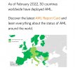
And while I am not familiar with all the technical aspects, I know that the AML (Advanced Mobile Location) system is being implemented in various phone networks and emergency system networks in European countries: When a person dials an emergency number the coordinates of the location of the caller are transmitted with the phone call (no internet access / mobile data network required).

See: Los 112 incorporan el Sistema AML que permite geolocalizar con precisión las llamadas realizadas desde un teléfono móvil
 
Last edited:
Holoholo automatically captures your footpaths, places, photos, and journals.
Which is also what the AlertCops app does: It allows a pilgrim to merely make a phone call to 112, plain and simple.
It is possible to use AlertCops to do just that, but the app offers several other ways of communicating with both the FFCCSE and nominated 'Guardians' - individuals/groups you have nominated to be informed should you trigger an alert. That is in addition to the warnings and other notifications that the app can provide, depending on the security level set. See for an explanation of all the functions available.

From what I have read, AML is a smartphone service (not an app) and is enabled on an Android in Locations settings. If it is enabled, when you call 112, the smartphone services sends an SMS message to the emergency service centre with your best location based on either GPS or WiFi, whichever is the more accurate at the time. There is a similar service in iOS.
 
Last edited:
AML is a smartphone service (not an app) and is enabled on an Android in Locations settings. If it is enabled, when you call 112, the smartphone services sends an SMS message to the emergency service centre with your best location based on either GPS or WiFi, whichever is the more accurate at the time.
I just enabled this on my Android. Thanks, Doug and @Kathar1na.

Easy:
Settings>Location>Emergency Location Service>click 'on'.

This is super simple, and works in the background with no effort - requiring neither apps nor knowledge of systems. Except to call 112. Simplicity under pressure is a blessing, and could save a life.

Question is...does it work in Spain? According to this, yes. Here's a screenshot:

Screenshot_20230317-174811_Opera.jpg
 
Last edited:
I just enabled this on my Android. Thanks, Doug and @Kathar1na.

Easy:
Settings>Location>Emergency Location Service>click 'on'.

This is super simple, and works in the background with no effort - requiring neither apps nor knowledge of systems. Except to call 112. Simplicity under pressure is a blessing, and could save a life.

Question is...does it work in Spain? According to this, yes. Here's a screenshot:

View attachment 143114
Screenshot_20230318-012149.png
This is the default for any of my phone's.
 
Ideal sleeping bag liner whether we want to add a thermal plus to our bag, or if we want to use it alone to sleep in shelters or hostels. Thanks to its mummy shape, it adapts perfectly to our body.

€46,-
Status
Not open for further replies.

❓How to ask a question

How to post a new question on the Camino Forum.

Most read last week in this forum

https://amp.theguardian.com/world/2024/nov/11/women-pilgrimage-camino-de-santiago-sexual-harassment Possibly behind a paywall - it’s about time this got a public airing in the mainstream media.
I've seen a few post elsewhere that suggest bringing a small cable and some type of padlock to lock your pack when going into stores, cafes or when at hostels. Other posts have said not to worry...
Aemet just issued a new alert for a possible new DANA in Spain this week. I don’t know where to find infos in english. Check aemet and other sources and take care everyone...

Featured threads

❓How to ask a question

How to post a new question on the Camino Forum.

Featured threads

Forum Rules

Forum Rules

Camino Updates on YouTube

Camino Conversations

Most downloaded Resources

This site is run by Ivar at

in Santiago de Compostela.
This site participates in the Amazon Affiliate program, designed to provide a means for Ivar to earn fees by linking to Amazon
Official Camino Passport (Credential) | 2024 Camino Guides
Back
Back
Top