On the guides, I walked in March this year with a few. The CSJ guide was the most up to date, but did not have the new route by the motorway on the way to Sigueiro, the route after Siguiero, and the route along the road out of Cos on the way to Hospital de Bruma.
That said, I learned after the first day not to carry to guide in hand, as I was reading one sentence ahead and trying to find the landmark described. It is best just to follow the waymarks, which are good, apart from one or two points a day. Sometimes the waymarks are not as frequent as you may wish, but if you are going straight, you just need to trust yourself that if the waymarks had told you to go left or right, you would have done so. The one point that does not help is as the Ingles is not as popular as other routes (which is the one of the attractions), there is not a steady stream of peregrinos in front of you to follow. You may see a handful of other pilgrims each day.
So if you take one guide, the most up to date appears to be the CSJ guide. I also took the Cicerone guide, as I like the coloured maps and I could gauge how far along the route I was. It does not have the new route to Hospital de Bruma, but if you are clever, when you come out of the forest onto the main road by the electricity sub station, you are actually on the A Coruna to SdC Camino Ingles, and the map in the Cicerone guide is accurate from there to Hospital de Bruma. The Cicerone guide map, whilst not following the route was also useful as a double check that the new waymarked route out of Sigueiro was going the right way.
Other things I took. I printed out Google maps of Ferrol, Fene, Pontedeume, Betanzos and Sigueiro, so I could find my accommodation, but these were useful for getting me across these towns, especially if I veered off Camino in order to find a restaurant or other thing that interested me.
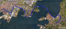
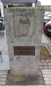
As noted above, in Ferrol, the Ingles starts at the harbour, and you have a sense of history starting at the stone there, just as the pilgrims of old would have started when they disembarked from their boats. There is a tourist office by the harbour (open till 6pm in the evening and from 10am in the morning), which can firstly issue credencials, stamp credencials, and also they have good free maps of Ferrol, almost out to the N-651 bridge, which have the Ingles route marked on it. There is also another tourist office in the big square by the station which is open till 7pm that does the same.
One tip if you arrive at Ferrol in the afternoon. The walk to Pontedueme is long for a first stage, if you are not stopping at Neda halfway. Going down to the harbour and walking from there to your hotel will save 45 minutes or so next morning, if you can do that bit 'in advance' and then in the morning, just walk out of your hotel, and using the tourist information map, join the Ingles route from whichever point is nearest.
Last thing about sellos. Your hotel in Ferrol should be able to give you a valid, initial, stamp for your credencial in the morning you leave (even if you have done the harbour to hotel preamble the evening before). You do not need to hunt around the town to the cathedral or tourist office for one. All you need is a stamp that shows you have started in Ferrol, somewhere.
Last point, as @jeffcrawley says, if you take the short cut across the N-651 bridge from Ferrol to Fene, as beautifully illustrated in the map provided by Jeff, even though you cut out the walk round the estuary, you still walk 100km from Ferrol to SdC, and you still qualify for a credencial. Nobody is going to ask why you did not have a stamp for Xubia or Neda and disqualify you for that. Yes, you take a short cut, but if walking all the way to Pontedeume on the first day, your legs may thank you for it on day 2. If I did my Ingles again, I would either cut the Ferrol to Pontedeume stage up into two and overnight at Xubia or Neda, take the N-651 bridge shortcut, or cut day 2 in half and overnight at the seaside town of Mino (which the Ingles skirts on the edge of, instead of going down by the beach at that point, instead of walking all the way to Betanzos on day 2. As a first stage, unless you are really fit and trained, the walk all around the estuary to Pontedeume is too long.


