Search 74,075 Camino Questions

New info (I think) about the caminhos south of Lisbon

Friend from Barquinha

Veteran Member
Time of past OR future Camino
None yet; perhaps the Portugese (2021?)
In the last year or so, there has been a fair bit of local Portuguese-language press coverage discussing how the tourism ministry, etc. can both help peregrinos in Portugal, and benefit from their presence.

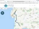
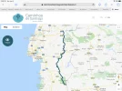
Today, in looking over some of this local stuff, I came across this website. Apologies if you've seen it before--it provides the best and most complete information I've seen about walking from the Algarve up to the Tejo (Tagus).


And they've put together a lovely video. I wish they'd covered our area as well--but thanks to the peculiarities of how the country's divided up in tourism districts, they've stopped just south of us in Golega--with a few quick shots of the Quinta da Cardiga, a lovely almost-abandoned manor house on the path from Golega to Vila Nova da Barquinha.


(or in Portuguese)


Bom caminho e feliz ano novo!
 
3rd Edition. More content, training & pack guides avoid common mistakes, bed bugs etc
Thank you for sharing this information. At some point I would like to return to Portugal and walk one of these routes from the south. Certainly, the guide gives much food for thought!
 
...and ship it to Santiago for storage. You pick it up once in Santiago. Service offered by Casa Ivar (we use DHL for transportation).
This is great! Thank you! We’re walking from Lisbon this year, but would love to do this area as well another time.
 
That’s nice, of course. But based on what I’ve read, I think a better albergue network between Lisbon and Porto should be the biggest priority regarding Portuguese caminhos. CP veterans, is that a fair comment?
@jungleboy I would say that this is accurate. A few more albergues on the long stretches would make the route lovely. But yet, for me personally, I don't mind staying in the family-run small hotels. I don't have a tight budget, and I enjoyed supporting those places. They were all so kind and helpful. And I do not like the great albergue race anyway! I figure my albergue tolerance rate is about 3 nights in a row! Ha ha. But that is just me and my opinion.
 
...and ship it to Santiago for storage. You pick it up once in Santiago. Service offered by Casa Ivar (we use DHL for transportation).
In the last year or so, there has been a fair bit of local Portuguese-language press coverage discussing how the tourism ministry, etc. can both help peregrinos in Portugal, and benefit from their presence.

Today, in looking over some of this local stuff, I came across this website. Apologies if you've seen it before--it provides the best and most complete information I've seen about walking from the Algarve up to the Tejo (Tagus).


And they've put together a lovely video. I wish they'd covered our area as well--but thanks to the peculiarities of how the country's divided up in tourism districts, they've stopped just south of us in Golega--with a few quick shots of the Quinta da Cardiga, a lovely almost-abandoned manor house on the path from Golega to Vila Nova da Barquinha.


(or in Portuguese)


Bom caminho e feliz ano novo!


That’s nice, of course. But based on what I’ve read, I think a better albergue network between Lisbon and Porto should be the biggest priority regarding Portuguese caminhos. CP veterans, is that a fair comment?

This is a lovely video, but it shows you what happens when a department of tourism takes over the camino, rather than housing responsibility in a cultural or historical agency. And I agree with @Friend that it would be more helpful to have the promotion coming jointly from all areas on the caminho, rather than respecting these arbitrary administrative jurisdictions.

I don’t mean to sound like a cynic, because it is really an exceptional video. Lots of lovely pictures, really gives you a good flavor of a lot of the beauty of rural Portugal. BUT... no specifics about the routes themselves. (Did I see a guidebook in there?). As I watched it, I saw a castle I recognized, Evoramonte, and the Roman temple in Évora and thought — those places are not on any camino I know about. Well, the schematic map at the end shows that there are several other routes being promoted here, but I wonder if there is any pilgrim infrastructure or good marking, or in fact any marking at all.

So I’m wondering if this department of tourism is biting off more than it can chew.

Back to the “normal” central Caminho from Lisbon, I think accommodation is pretty good, but agree with @jungleboy that more albergues south of Porto would do far more to increase traffic than these videos. Like @elle, I enjoy the private accommodations, but I think that without a base of good albergues, no caminho can prosper. But that gets us back to the fact that this effort is spearheaded by the Tourism folks, and they are all about spearheading private touristic development.

I am assuming that these are the folks that @Rodrigo Cerqueira and his group have locked horns with, and this may be a good David vs. Goliath opportunity!
 
An interesting discussion. I think one thing to remember is that in the Portuguese Catholic community, interest in the Camino de Santiago is a very small part of their concern. Fatima is "the real deal." And the volunteer activities that go into supporting pilgrims taking the holy walk to Fatima, often in very large groups and quite regularly, are impressive. Doctors, nurses, physiotherapists, massage therapists donating their time to drop-in clinics along the way during the holy periods, and a lot more.

Definitely the current interest in promoting the southern Camino de Santiago routes is much more tourism-based and looking at increasing tourist interest in the interior parts of the country, rather than Lisbon, Porto, and the Algarve. Thus the pretty video. These routes go through the equivalent of the American west. Hot and dry, very empty--these were the wheatfields of the Romans! And the poorest part of Portugal, with not a lot of other options for revenue.

If you like walking that kind of country and are looking for the solitude, rather than fellowship, of an introspective camino, this could suit you well. Likely not enough people will do it to make albergues practical in the shorter term, but it's an inexpensive, hospitable and quite beautiful part of the country, and definitely a different experience.
 
If you go to the website, you can see more information about the stages they propose, etc. The route they call the Central Way doesn’t go through Lisbon, though, but is a good option for those walking the Fisherman’s Way who want to continue on the Caminho — bypass Lisbon and connect further north.
And what they call the caminho Nascente goes from the Spanish border through Alcoutim and then north through Evora, Evoramonte, Estremoz, Crato — again a very nice route to take to explore rural Portugal. But I remember that the Fátima folks had used the name Caminho Nascente to describe options for getting to and from the Caminho de Santiago to Fátima, so I suppose this is not to their liking. And there is a third caminho they have not yet posted info about, the Caminho da Raia, so that gives yet another option.

@Friend from Barquinha, do you know anything about the marking?

The website has gps tracks, lots of information about stages, and anyone thinking about walking these routes will find lots of info on the website. https://www.caminhosdesantiagoalentejoribatejo.pt/en/
 

Attachments

  • BC6E209D-FE4C-41F3-83ED-7AB6FD63D91E.webp
    BC6E209D-FE4C-41F3-83ED-7AB6FD63D91E.webp
    259.4 KB · Views: 13
  • 65CDDCDE-DECD-494B-A5B0-108E173B3AA8.webp
    65CDDCDE-DECD-494B-A5B0-108E173B3AA8.webp
    271.8 KB · Views: 15
3rd Edition. More content, training & pack guides avoid common mistakes, bed bugs etc
P.s. on the marking question, I get the impression the first thing they did, before they started promoting these routes, is mark them. I know I was in the area near Crato in late fall 2018, and was very surprised to see route markers in a tiny town, Vale do Peso, just north of Crato. Much better markings than the yellow arrows I see on the street near us, in the area of Vila Nova da Barquinha that's right on the path!

@peregrina2000--does this answer your question? I know, from my admittedly sketchy readings of some of the Portuguese-language local online press (and there's a lot of it in Portugal!), that there's quite a bit of local-town, regional, national, and EU money going into this initiative, and I believe that much of it is going into what they consider the critical infrastructure--putting up the signposts.

As others have mentioned, the route perhaps sometimes is slightly diverted because of local interests, but I would guess not much--most of these places are so small that there's not many diversions that can be made!
 
In the last year or so, there has been a fair bit of local Portuguese-language press coverage discussing how the tourism ministry, etc. can both help peregrinos in Portugal, and benefit from their presence.

Today, in looking over some of this local stuff, I came across this website. Apologies if you've seen it before--it provides the best and most complete information I've seen about walking from the Algarve up to the Tejo (Tagus).


And they've put together a lovely video. I wish they'd covered our area as well--but thanks to the peculiarities of how the country's divided up in tourism districts, they've stopped just south of us in Golega--with a few quick shots of the Quinta da Cardiga, a lovely almost-abandoned manor house on the path from Golega to Vila Nova da Barquinha.


(or in Portuguese)


Bom caminho e feliz ano novo!
I am pretty much set to walk from Cabo de Sao Vicente to SDC beginning in March. I used the Rota Vicentina site to Lisbon. https://www.caminhosdesantiagoalentejoribatejo.pt/mapas/, is yet another good site for more research, thanks for sharing.
 
The 2024 Camino guides will be coming out little by little. Here is a collection of the ones that are out so far.
The word "nascente" means source. Looking at the post that Elle refers to, that's talking about a "new trail" between Tomar and Fatima, just built, so they can call it what they want! The page says

"It's officially open and marked the new way Caminho Nascente
The new 29.3 km way connects Fatima to Tomar or vice versa. It's a two-way path marked, to help the Santiago pilgrims who come to Fátima to return to the original Caminho de Santiago in Tomar."

So presumably that means it takes these Santiago pilgrims, who've detoured to Fatima to visit another holy site, back to the "route to the source" which would be the caminho north to Santiago.

Note that the end of the Facebook post states:
"This is not the way of Santiago, nor was it done any historical study of this path." So presumably the use of the name is coincidental.

If you go to the historical page on the new "Alentejo/Ribatejo" caminho website, they give a long, complex story of these southern routes, going back to Moorish times 1000 years ago. And they refer to the orders that were given the responsibility of protecting the caminhos at that time. So when they say "source" aka Nascente, they're speaking in a very different context. (This historical page is really hard to read. Badly laid out, and I believe translated from Portuguese--and not in the most approachable way.)

Note that what in English is labelled as the Eastern Way is called in Portuguese the "Source/Nascente caminho" and that the historical discussion talks about the Order of Santiago as an order originally of warrior monks, and that their base was first at Alcacer do Sal south of Lisbon, and then, as the Christians pushed the Moors south, for hundred of years in Mertola, well south on the Eastern way. (Note that Mertola church is identified as one where you can get a Pilgrim's Passport. Mertola is well worth visiting.)

The page notes:

"The uniquely peninsular scope of the Order was evident in its statutes: to protect not only the southern borders of the Iberian Peninsula’s Christian kingdoms, but also the pilgrims who came to Santiago de Compostela cathedral to worship the apostle’s tomb."


So they both can be considered "source" in their own ways. It is unfortunate that everyone in Portugal working on/committed to improvements on the Caminho isn't part of the same group and using the same background, but it's good that it's happening, anyway, right?
 
Last edited:
You have to excuse my enthusiasm about "route-tracking." I seem to be developing a passion for historical detection as I learn more about the small towns and the history of Portugal and the caminho is such an integral part of Iberian history!

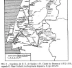
A few months ago I posted, on this forum, a map from our town's Mayor, Fernando Freire, who is a history buff himself. (Reading his blog and others are as good a way as any, I figure, to work on my Portuguese, and the subject matter is fascinating to me.) The post included a map I copied from his blog:
1578264483194.png

An interesting and likely untried caminho route the length of Portugal would use a combination of one of these newly publicized southern routes, plus one from Lisbon north. I would suggest the Eastern/Nascente Way, starting in Tavira and going through Mertola up to Evora, and then heading northwest for Escoroupim and up and across the Tejo to Santarem, at which point you joined the traditional central route north! You would need time; I'm pretty sure that Evora to Escoroupim stage wouldn't be signposted! This would be a route of rolling hills and plains, mostly. Beautiful, almost empty country.

Near Evora, you might want to take a detour and see this! An amazing site and, unlike Stonehenge and others, you can freely walk among the monoliths.

1578274986691.webp


But back to the caminhos!

This map of the old routes is also particularly interesting to someone like me from Vila Nova da Barquinha, because the double dashed route shown on the map goes through Barquinha but comes northwest from the "Nascente" route through Evora. (There are dammed rivers in the Alentejo that have created long lakes that likely have forced detours on the original route.) This would be an entirely different approach to Barquinha than the standard one, and would have required pilgrims to cross the Tejo (Tagus) here. Interestingly, the more eastern town in our municipality is Tancos, which was a harbour for the olive-oil carrrying boats going down the Tejo to Lisbon, pre-railroad. Tancos has a "paired" town on the other side of the Tejo, and apparently, originally the two towns were once one, in spite of having a major river in the middle! There is still a yearly ceremony where they move the statue of a saint from one town to the other by boat, to rest for a year in the partner church. A year later, the reverse happens.

I can imagine pilgrims walking up from Ponte do Sor to the south side of Tancos, taking a small boat across the river, walking along the north side of the river to Barquinha (about 4 km), and then heading up hill to Atalaia, there to meet another group of pilgrims walking north from Lisbon and Santarem!

Interestingly, in the eastern part of Barquinha itself, there is a small, very old chapel that is unused and in bad shape (and in the middle of nowhere), named for Sao Roque Amador who is described as being a pilgrim himself,commemorated for his healing of plague victims. He is depicted in standard pilgrim garb (picture below from Wikipedia). So I'm wondering if this out-of-the-way abandoned chapel would have been for those pilgrims from Tancos, coming up from the Alentejo through the Middle Ages?

1578264466055.png

All fascinating stuff!
 

Attachments

  • 1578274962093.webp
    1578274962093.webp
    166 KB · Views: 1
Last edited:
I am considering taking on one of these new routes, possibly starting from Faro and going all the way to SdC. Finding it hard to get information on any trails leaving Faro. I don't fancy walking on many Portuguese roads. They are bad enough behind a steering wheel!

I'd plan to go from the Algarve via Lisboa, Porto then the coastal way as I have done the central route.
 
3rd Edition. More content, training & pack guides avoid common mistakes, bed bugs etc
Understand completely, @anthikes! "Finding it hard to get information on any trails leaving Faro. I don't fancy walking on many Portuguese roads. They are bad enough behind a steering wheel!"

I don't know if this would help or not, but the website covers bike touring in the Algarve. Presumably they plan routes that are reasonably safe for bikes--and thus might be safer for walkers as well? Their maps seem to cover a lot of side roads.


Once you get north of the Algarve, and into the Alentejo, the drivers can still be as crazy but there are not very many of them. This is definitely the empty part of Portugal. And the roads tend to be straighter, with not as many blind corners as there can be in the hillier areas further north. So bearable, I think.

Bom caminho!
 
Last edited:
I don't know if this would help or not, but the website covers bike touring in the Algarve. Presumably they plan routes that are reasonably safe for bikes--and thus might be safer for walkers as well? Their maps seem to cover a lot of side roads.


Once you get north of the Algarve, and into the Alentejo, the drivers can still be as crazy but there are not very many of them. This is definitely the empty part of Portugal. And the roads tend to be straighter, with not as many blind corners as there can be in the hillier areas further north. So bearable, I think.

Bom caminho!

Thanks for the link - looks interesting and I am definitely keen to be a bit of a pioneer on this route. The tourist board have appeared to invested a lot in the Alentejo camino information and hopefully markings too.

Would love to hear from anyone else who has started from the Algarve? I am also considering the Fisherman's path too from Cabo, but have this urge to start from Faro!
 
One of my Portuguese friends has just walked this Camino, or the combo of Caminos to be precise. He started from Tavira at the begining of Dec 2019, taking so called Camino Nascente first following the Spanish border, then through Beja, Evora, Castello Branco, Guarda, Braganca. From there he crossed over to Spain and got to Verin, then walked on to Ourence from there on the Camino Sanabres. From Ourence he turned back home in the direction of Porto - he'd chosen to walk Camino da Geira backwards, these 2 Caminos pass a short distance from each other there, so technically it's possible to cross over following the river.
From what I've heard from him about the route from the south it sounds like the one for those who love adventure :) It's more of less marked in the south, there are even occasional albergues there, but most of the time he had to stay in hostels and pensions, and in bombeiros/firemen headquarters a couple of times. I remember him telling the area is sparcely populated and there was a shortage of water there, the villages are far between and the water supply is irregular, he didn't suffer much in winter but in summer that would make a difference. He had to carry food on many of the stages as in winter not much is open there.
I've seen his pics from the road and the views are breathtaking though! Eagles, mountains up to 2000ms, rivers to cross when they were flooded last Dec, colourful street-art in many towns on the way, innumerable churches, the tunnels of the abandoned railway line, you name it! I wish I could walk there one day, but probably in another, warmer season as some of the places don't have any heating so he had to use all the warm clothes and several blankets to keep warm. He is now walking on Camino da Geira backwards, and reports existing but not excellent markings there, so he primarily uses GPS there. Walking from the south he followed the yellow arrows where there were marks and also used and GPS and said his mobile with maps and GPS was essential on that route.
 
Ideal sleeping bag liner whether we want to add a thermal plus to our bag, or if we want to use it alone to sleep in shelters or hostels. Thanks to its mummy shape, it adapts perfectly to our body.

€46,-
I've also been thinking of walking the entire length of the Portuguese coast from Lagos to Santiago (and even onwards to Malpica by way of the Camino Finistere & Dos Faros). This is a great resource to help bridge the route gap I had between Satiago do Cacem and Lisbon/Santarem. I even dream of a complete circumnavigation of the Iberic peninsula including the GR10/11... I'll be looking forward to to reports! Thanks for sharing.
 
One of my Portuguese friends has just walked this Camino, or the combo of Caminos to be precise. He started from Tavira at the begining of Dec 2019, taking so called Camino Nascente first following the Spanish border, then through Beja, Evora, Castello Branco, Guarda, Braganca.

Great info thanks! Yes that way would not be one for the summer months! I could handle the lack of accommodation (would carry an ultralight tent) and even places to buy food (I am use to carrying 4/5 days of food on wilderness trips) but the water situation would be my biggest concern. Food for thought anyway!
 
Yes that way would not be one for the summer months!

To add to that, for the Rota Vicentina, in the same general area of southern Portugal (Algarve/Alentejo), the official site specifically recommends not walking in summer:
All Summer season, particularly July and August, is not the best season to walk in the Rota Vicentina. It’s too warm, with average temperatures inland getting above 30ºC, what makes the walking day pretty tough. For a much more rewarding experience, follow our recommendation and avoid Summer if your goal is to enjoy this region while hiking in the RV.
 
Ideal pocket guides for during & after your Camino. Each weighs only 1.4 oz (40g)!
Great info thanks! Yes that way would not be one for the summer months! I could handle the lack of accommodation (would carry an ultralight tent) and even places to buy food (I am use to carrying 4/5 days of food on wilderness trips) but the water situation would be my biggest concern. Food for thought anyway!
There is accommodation on the route there, so no need to carry a tent, it's not really a hike through the wilderness, it just depends if you are flexible with the distances. For those who like/are limited by walking 10-15 km/day that might be slightly problematic as some stages could be longer. Same about food: there are shops and supermarkets on the way, they bought food and cooked sometimes, often eat out in the evening - you could find open bars and restaurants in winter, just not that many as in other seasons, and they carried food for 1-2 days at a time usually. The only tricky stage food and housingwise was between Braganca and Verin as far as I remember, but also manageable in the end. Most or a grear part of this way is hilly/mountanous, much harder then CPI - Camino Portugues Interior that we walked before from Viseu. So I guess it's more for the experienced walkers/hikers. My friend was pressed for time and also walked on a budget, he usually made 30-40km/day almost every day of the way. Also he carried just 2 small 0.5l bottles with him, said was ok for him, but his companion had 2 large bottles instead.
 
The word "nascente" means source. Looking at the post that Elle refers to, that's talking about a "new trail" between Tomar and Fatima, just built, so they can call it what they want! The page says

I have received a PM from a Portuguese friend and former forum member who wanted to clarify some of what @Friend wrote. Here is the message I received:

The Nascente Path to Santiago is the old eastern route, which began in the city of Tavira in the Algarve and which Turismo de Portugal wants to turn into a tourist route and not a path for pilgrims.

I see the translation:
"The word "nascente" means source"

But such, in this case, NASCENTE in Portuguese means east and not SOURCE.
There is also the Nascente Path to Fatima, which is older than the name of the Nascente Path to Santiago.
But these are things that only the tourism knows.

As Rodrigo says:
"We choose to be pilgrims, not tourists"

At this moment Rodrigo Cerqueira, together with other volunteers, has already created the Southeast Way that unites the city of Nisa with the Fatima sanctuary.
I have already proposed to him to continue marking until the Sanctuary of Guadalupe, which are the two most important sanctuaries of the Iberian peninsula. The sanctuary of Guadalupe already has the marked path to the city of Cáceres.


We have seen the same issues when the Spanish national tourist agency got control of the Camino, taking it from the department of culture/history (not sure of the exact name). These two different focuses tend to produce lots of tension and conflict, understandably, since their goals are different. And in this case it is complicated by the fact that Fátima is the most important pilgrimage destination in Portugal, as @Friend described, with the caminho lagging far behind in terms of popular opinion.

So it looks like these jurisdictional battles will continue for a while, and it is a sad commentary on our human nature, I believe.
 

❓How to ask a question

How to post a new question on the Camino Forum.

Featured threads

❓How to ask a question

How to post a new question on the Camino Forum.

Featured threads

Forum Rules

Forum Rules

Camino Updates on YouTube

Camino Conversations

Most downloaded Resources

This site is run by Ivar at

in Santiago de Compostela.
This site participates in the Amazon Affiliate program, designed to provide a means for Ivar to earn fees by linking to Amazon
Official Camino Passport (Credential) | 2024 Camino Guides
Back
Back
Top