• ⚠️ Emergency contact in Spain - Dial 112 and AlertCops app. More on this here.
  • Remove ads on the forum by becoming a donating member. More here.

Search 74,075 Camino Questions

My notes on railway bridge shortcuts Conduché – Cahors on the Célé variant

Matthew Fitzhenry

New Member
Time of past OR future Camino
Le Puy-en-Velay, 27 April - 12 May 2023
I want to add my notes towards taking the three railway bridge shortcuts on the section Conduché – Cahors.

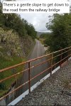
Bridge 1: After coming down from the descent into Conduché I took the GR651 along the D662 into Bouziés. This was surely the most dangerous section I encountered. One of my fellow French pilgrims took the railway bridge to cross the Lot. I would recommend anyone taking this route not to follow the official path – there is very little room to walk, and you must keep your wits about you. Take the bridge.Conduché_bridge.JPGGR651_avoid.jpg

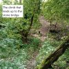
Bridge 2: Crossing the stone bridge after Bouziés (44.469541, 1.607407) – You can find the bare track that leads up to the stone railway bridge, as steep climb. Avoid taking the very first path down after crossing the bridge. Follow the tracks until it passes overhead the road. Getting down to the road via the right-hand side is the easiest way.
PathBridge2.jpg
youhavedoneit.jpgIMG20230511104508.jpggettingdownstonebridge.jpg

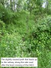
Bridge 3: Crossing the steel bridge after Velles (44.467765, 1.544546) – Walking a little way after the railway crossing on the D653, you will find another bare track leading up to the rails. The path along the rails is marked by orange ‘balisage de securité’ hanging before and after the bridge to guide you. I have the GPX files if anyone is interested, but I cannot attach them here.

PathtoBridge3.jpg
RailalongBridge3.jpgBridge3ann.JPGmarker.jpg
 
3rd Edition. More content, training & pack guides avoid common mistakes, bed bugs etc
Thank you for taking the time and making the effort to put together this information. Bon chemin.
 
Note that there is no more train crossing this bridge.
I was not aware there was another itinerary than this one: it allows not only to cross the Lot on a former railways, but also leads to the "chemin de Halage" (towpath ?) along the Lot. Furthermore, if you have a little spare time, do not hesitate to climb on Saint-Cyr-Lapopie, a very nice village !
 
Train for your next Camino on California's Santa Catalina Island March 16-19
I want to add my notes towards taking the three railway bridge shortcuts on the section Conduché – Cahors.

Bridge 1: After coming down from the descent into Conduché I took the GR651 along the D662 into Bouziés. This was surely the most dangerous section I encountered. One of my fellow French pilgrims took the railway bridge to cross the Lot. I would recommend anyone taking this route not to follow the official path – there is very little room to walk, and you must keep your wits about you. Take the bridge.View attachment 148454View attachment 148453

Bridge 2: Crossing the stone bridge after Bouziés (44.469541, 1.607407) – You can find the bare track that leads up to the stone railway bridge, as steep climb. Avoid taking the very first path down after crossing the bridge. Follow the tracks until it passes overhead the road. Getting down to the road via the right-hand side is the easiest way.
View attachment 148465
View attachment 148466View attachment 148467View attachment 148468

Bridge 3: Crossing the steel bridge after Velles (44.467765, 1.544546) – Walking a little way after the railway crossing on the D653, you will find another bare track leading up to the rails. The path along the rails is marked by orange ‘balisage de securité’ hanging before and after the bridge to guide you. I have the GPX files if anyone is interested, but I cannot attach them here.
View attachment 148469
View attachment 148470View attachment 148471View attachment 148472
Many thanks
I wish I had known this some years back. I followed the official route to Cahors which was very stony and pointless in places and very hot.
Little did I know the French walkers like to make some sections of their walking route, not the one we as pilgrims have adopted, rather challenging and to avoid some villages
Oh well.
 
Thanks to the OP for the detailed Info on the three bridges. I just walked 2/3 of them and found the descriptions to be very accurate.

As of yesterday Bridge 2 has a LOT of vegetation that you need to walk through (10 min of walking). It's doable but I would recommend long pants. I wore shorts and emerged with many scratches on my leg. To clarify, the exit point is immediately after you walk over road D662.

For bridge 3, I asked the owner of the gite I stayed at in Vers and he said there is some construction going on with the bridge and it is not currently accessible. Not sure if he was just trying to warn me off or not but in any event I took his advice and didn't check it out.
1000018110.jpg
 

❓How to ask a question

How to post a new question on the Camino Forum.

Most read last week in this forum

Hi there, I'm considering walking from Le Puy to St. Jean next spring if I can get my French up to par. I'm looking on advice on a few things: - Would it be too cool and rainy to start walking...

Featured threads

❓How to ask a question

How to post a new question on the Camino Forum.

Featured threads

Forum Rules

Forum Rules

Camino Updates on YouTube

Camino Conversations

Most downloaded Resources

This site is run by Ivar at

in Santiago de Compostela.
This site participates in the Amazon Affiliate program, designed to provide a means for Ivar to earn fees by linking to Amazon
Official Camino Passport (Credential) | 2024 Camino Guides
Back
Back
Top