• ⚠️ Emergency contact in Spain - Dial 112 and AlertCops app. More on this here.
  • Remove ads on the forum by becoming a donating member. More here.

Search 74,075 Camino Questions

Lyon to Le Puy on foot

RichaM

New Member
I'm sure this has been covered before - I just can't find it....

But - I know there's a walking route from Lyon to Le-Puy. Any tips / pointers / links anyone could please help me with?

Is there anywhere to avoid, how pilgrim friendly is it, gites and so on?

Any advice very gratefully received.

Thanks,
Richard.
 
...and ship it to Santiago for storage. You pick it up once in Santiago. Service offered by Casa Ivar (we use DHL for transportation).
The real place to get the answer you want is the French walking organization, FFRandonee. However, their website (http://www.ffrandonee.fr) does not appear to be functional this afternoon - so I don't know the story. If you sent the request, in both English and French, to info @ ffrandonee .fr you should get a correct answer.

In the interim, looking at the map on the Standsford site (http://www.stanfords.co.uk/Cities/A...FRP-Topo-guides-with-Day-Walks_SI00000384.htm) it appears you have two choices coming out of Lyon, to connect you with the GR 65 coming from Geneva to Le Puy: (1) head south along the Rhone valley (no route marked but surely there must be one), or (2) head west and pick up the GR 7 or GR 76 running south.

Again, this is an incomplete map and I'm just making a stab at this until you can get a real response from the French organization.
 
Join the Camino cleanup. Logroño to Burgos May 2025 & Astorga to OCebreiro in June
Yes, I met a Frenchman who had walked from Lyon on the Cluny route. He had taken four days on a route from Lyon to join the Cluny route near St-Georges-Haute-Ville, which is about 9km past Montbrison. From that junction it is about another four days walking to Le Puy. Both these routes are covered in the Amis guide mentioned by backpack45scb.
Margaret
 
RichaM said:
A French friend found this one aswell - http://www.lyon-compostelle.com/chemin_cesar.html.It's in French but well structured, pretty easy to follow and quite useful. Richard.
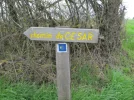
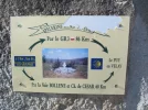
Richard, what your friend found is basically the chemin that is described in the Orange guide by the Amis de St Jacques- except for one day. The route to La Cruzille is exactly the same as in the orange guide- La Cruzille is just 0.7km off the chemin, which you rejoin in the morning until just after Montarcher. This then becomes the day when you have a deviation from the chemin described by the Amis, and take a section of the GR3 as far as Apinac. The sign below is found in Montarcher.

The following morning you are taken by a car journey of about 12km to Pontempeyrat, which is where you are rejoining the chemin as listed in the orange guide.

In the latest (2012) orange Amis guide to the chemin, there is some info about the GR3 section (but this didn't appear in the 2008 version). My French friend actually warned me off taking the whole GR3 as he said it was very mountainous and the gites were far apart- but perhaps the main difficulties on the route come after Apinac where you would stay the night.


If you do decide to take the deviation along the GR3 to Apinac, you have to be very careful about a kilometre after Montarcher where the two routes deviate, as the balises that show the deviation are quite small, and there are no major signposts.


This last sign is one you see shortly after climbing out of Pontempeyrat, and you are back on the chemin as described by the Amis at this point.
Margaret
 

Attachments

  • signs 2.webp
    signs 2.webp
    127.7 KB · Views: 988
  • chemin de cesar.webp
    chemin de cesar.webp
    112.8 KB · Views: 983
  • chemin deviation.webp
    chemin deviation.webp
    70.3 KB · Views: 982
The focus is on reducing the risk of failure through being well prepared. 2nd ed.
Hello,

In mid August I plan to run from Lyon down to Moissac but have had quite a bit of trouble finding a good guide from Lyon to Le Puy. I bought the red guide but the guide is really only useful from Geneva to Lyon and then only turns into a very unsatisfactory mini-map with no instructions of the route.

I have considered getting this guide http://www.stanfords.co.uk/Countrie...es-ClunyLyon---Le-Puy--pied_9782844660565.htm

Does anyone know if this has any decent maps/description of the route?

Also has anyone actually gone along this route? If the signposting is very good then there might not be so much need for a map as I have plenty of information on accommodation etc.

Thanks all!


Jonathan
 
Hello,

This guide, in French :

http://www.amazon.fr/dp/2844660568/

is somewhat outdated (printed in 2002) but contains really decent maps. In fact copies of IGN (French Survey) 1/50,000 ones.
I used it in 2013 between Charlieu and Le Puy.

Lyon to Saint-Georges-Haute-ville is described in 4 stages (18 - 24 - 14 -21 km). The chemin is traced on the maps. The comments are in redacted French, which calls for some command of the language, even if the vocabulary scope is limited.

This guide is based on the GR3 after Apinac. Rather tough as mentioned above, specially when approaching Retournac , and longer than the alternative.
 
A selection of Camino Jewellery
the updated version of the accommodation list for the via lugdunum (voie de lyon). updated after I walked it this july, with the help of 'guide rouge'.
 

Attachments

I can tell you that there are very historical and authentic routes. We drove it, but found wonderful things, such as ancient coqiilles carved into the rock

Out kf the country now but can dig up details if you send a PM
 
When it comes to the Camino de Santiago, the FFR is not necessarily the right source (except for the 4 major routes) if you want to follow Caminos. In France, they are left to be created and taken care of by regional associations (except, again, for the 4 major routes)
The one for your stretch is the Rhone-Alpes association of the Camino. Imo, "their" Caminos are pretty well marked and easy to follow.
-> their website in French only (imo, not really easy to use and not too many info)
Here's a map of the Caminos in their region (can find it and zoom in on the website)
carte_rhone_alpes.jpg

Here's the itinerary from Lyon. Also useful, a more detailed map of the itinerary through Lyon here.
You can buy the exact booklet for this route (red one!) on this page, that includes maps, charts (with distances, villages and their accommodations and available services), lists of addresses/phones/detailed accommodations and services/touristic information for each village. If you want to buy it, it's here and they only send it by mail.
On the same page, there are also recent itinerary changes (watch for "modification itinéraire") and downloadable GPS files (below the booklet's picture)

That said, like said above, there are various others options... :)
Buen preps!


full
 
€2,-/day will present your project to thousands of visitors each day. All interested in the Camino de Santiago.

❓How to ask a question

How to post a new question on the Camino Forum.

Most read last week in this forum

Hi there, I'm considering walking from Le Puy to St. Jean next spring if I can get my French up to par. I'm looking on advice on a few things: - Would it be too cool and rainy to start walking...

Featured threads

❓How to ask a question

How to post a new question on the Camino Forum.

Featured threads

Forum Rules

Forum Rules

Camino Updates on YouTube

Camino Conversations

Most downloaded Resources

This site is run by Ivar at

in Santiago de Compostela.
This site participates in the Amazon Affiliate program, designed to provide a means for Ivar to earn fees by linking to Amazon
Official Camino Passport (Credential) | 2024 Camino Guides
Back
Back
Top