• ⚠️ Emergency contact in Spain - Dial 112 and AlertCops app. More on this here.
  • Remove ads on the forum by becoming a donating member. More here.

Search 74,075 Camino Questions

Lavender Festival near La Lana

peregrina2000

Moderator
Staff member
@C clearly and I saw fields of lavender last year on our walk on the Lana. (We also saw fields of purple with purple flower cover crops, but some were lavender). Today I saw an article about the town of Brihuega, about 30 km from the town of Trillo on the Lana. Seems like they’re trying to compete with Provence!

This is a very untouristy part of Spain, and some of the other places the author visited seem really nice.

Hope this link works: https://www.nytimes.com/2024/07/10/...e_code=1.8k0.OV27.HJrZO7mH-ac1&smid=url-share
 
Last edited:
The 2024 Camino guides will be coming out little by little. Here is a collection of the ones that are out so far.
@C clearly and I saw fields of lavender last year on our walk on the Lana. (We also saw fields of purple with purple flower cover crops, but some were lavender). Today I saw this article about the town of Brihuega, about 30 km from the town of Trillo on the Lana. Seems like they’re trying to compete with Provence!
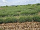
Here is a lavender field beside the Ermita de San Blas, just before Cifuentes. The photo was taken on May 29, so the field would have been in peak bloom a couple of weeks later.


As you know I am always looking for caminos for the future and La Lana is on the list. What time of year did you walk? I refuse to walk in hot weather. I would take waking up to 28F or so and expect a high of 40 than waking up to 78 or 80F and expect a high in the 90's or above. I think about 40-50 is really optimal walking conditions.
Whoops now that i I see @C clearly wrote May 29 I have a better idea haha but when did you start and what were the temperatures like. I know weather history is not always indicative of future weather these days.
PS the lnk did not work for me.
 
€2,-/day will present your project to thousands of visitors each day. All interested in the Camino de Santiago.
I added a new link in the first post. I always have trouble “gifting” New York Times articles, so let me know if this one doesn’t work. The small towns and waterfalls he visited in that area would make for a very nice short trip in connection with the lavendar festival - all so far from the tourist drumbeat!
Thanks, the link worked for me but I have a subscription to the Times also. I think there is a limited number (maybe 10) of links you can "gift" to others each month. But what about the temperature hahahaha!!!!!!
 
Thanks, the link worked for me but I have a subscription to the Times also. I think there is a limited number (maybe 10) of links you can "gift" to others each month. But what about the temperature hahahaha!!!!!!
Temps were very pleasant. Off the top of my head, with a quick glance at my FindPenguins, I can’t remember anything too hot. But I just noticed that if you look at my FindPenguins, you will see a temperature and weather icon posted. I am assuming that the program automatically inserts those indicators at the time of posting, but I am not 100% sure. I’ve written them to ask. In any case, it will give you an idea of what the temps were when I posted footprints, typically between 5-7 pm, I think.
 
haha but when did you start
oops, I missed this question. I started from Villajoyosa on May 11 (2023). The drought in the south was extreme. Many fields of entirely failed crops. As we got further north, both the wildflowers and the health of the crops improved. I am not sure what the drought situation in Spain is these days, but we met many very distressed people along the way.
 
Train for your next Camino on California's Santa Catalina Island March 16-19
I got to wondering about the drought in Spain, since I did not experience any apparent effects of a drought in April-May this year. But I was over in the west.

There is a good government site. Its map shows that the drought continues in many of the eastern parts of the country, and it looks like it still covers the lower part of the Lana.

But the map on this page shows that the level of water in many reservoirs throughout Andalucía, Catalunya, and other parts of Spain is still very much near or at crisis level.
 

❓How to ask a question

How to post a new question on the Camino Forum.

Featured threads

❓How to ask a question

How to post a new question on the Camino Forum.

Featured threads

Forum Rules

Forum Rules

Camino Updates on YouTube

Camino Conversations

Most downloaded Resources

This site is run by Ivar at

in Santiago de Compostela.
This site participates in the Amazon Affiliate program, designed to provide a means for Ivar to earn fees by linking to Amazon
Official Camino Passport (Credential) | 2024 Camino Guides
Back
Back
Top