• Remove ads on the forum by becoming a donating member. More here.

Search 74,075 Camino Questions

Just...Wow!

Time of past OR future Camino
Various 2014-19
Via Monastica 2022
Primitivo 2024
€2,-/day will present your project to thousands of visitors each day. All interested in the Camino de Santiago.
And please can you give those of us who are behind the curve with tech some brief instructions on how to open the file?

I can open this online, of course, but can it be downloaded? I found the share function but cannot download the file in any format that my mapping app (Osmand) can identify and open.
 
Last edited:
Perfect memento/gift in a presentation box. Engraving available, 25 character max.
Holoholo automatically captures your footpaths, places, photos, and journals.
I opened the map. On my laptop. I know you say you are not a techy, Vnwalking. In relation to using maps, either real or techy, I am a no-hoper. Give me the first guide we had from the CF - the CSJ. Small, light, no maps. However, my best guide is my walking companion, so I just need to pay attention to following her! All I ask is the truth about the gradient ahead...
 
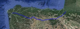
This is an amazing piece of kit which I will play with for hours find extremely useful. I think the blue circles are a GPX trail, but more tech-savvy contributors will doubtless come along shortly. Many thanks to VNWalking for finding it.
 
You may have found this but under the share option there is a panel that opens and has a download ability. The only files are gpx,goejson,and kml. But that should work as a kml. It downloads everything into one file. You can then open up google earth and select what you want to. It's displays the Camino routes as white lines which is a little hard to read. There are also a lot of segments.
 
The one from Galicia (the round) and the one from Castilla & Leon. Individually numbered and made by the same people that make the ones you see on your walk.
Now you've made me all excited and wanting to get back onto a Camino again. Wish we had had access to this when we did our first and, hopefully, we will still be able to in September this year. Lots of factors riding on this, not least the debacle over Brexit, and health of two people who are six year's older than when we last went made our way to Spain.
 
Wow indeed, it's a bit like being served a 12 course banquet when all you wanted was a biscuit!
Isn't this the same as the one from the Dutch OSM site? The data includes the Dutch files we already have under resources but so much more besides.

Go to the icon that looks like a stack of coins and click. You'll get a list of all the caminos included on the map.
Click the eye icon to switch them off/on individually
The blue circles around Logrono are Points of Interest. They seem to have been left visible when somebody uploaded the file. Not particularly useful - there are dozens of "crosses" with no additional data.
Not that, as with all files like this, it's out of date - at least the Camino Ingles is at least as it's showing the old route.
More later if I can figure out how to strip out individual routes - today's mind exercise!
 
Last edited:
Holoholo automatically captures your footpaths, places, photos, and journals.
You may have found this but under the share option there is a panel that opens and has a download ability. The only files are gpx,goejson,and kml. But that should work as a kml. It downloads everything into one file. You can then open up google earth and select what you want to. It's displays the Camino routes as white lines which is a little hard to read. There are also a lot of segments.
I think, if you do want to download, the easiest way is to:

go to share,
switch off every route you don't want,
choose whether you want .gpx or .kml
download

say you chose .kml

you can open this in Google Earth (other cartographic readers are available!) but you still get a spider's web of routes.

By picking out the individual pathway>properties you can then change the colour to one that suites:
54373

Just. So. Much. Information . . . ;)

Consider it a menu from which you can select your meal - trying too much at once may give you indigestion!
 
I have had a look at this and have two questions for those who understand these things:
1. Can it be downloaded for offline use? If not, it is something to play with at home, but no use to me on camino. I do not use Google Earth when travelling, as only a tiny bit of what I am looking at online remains when I go offline. I suppose that I can use it with wifi to look at the next bit of my route but I currently find maps.me more useful when I walk than Google Earth.
2. If I can download it for offline use, or find a way to download only the route that I am using, will my location show up, so that I can see where I am in relation to the map and to the camino route?
These may both be stupid questions, for the people who can answer them, but I would like to know.
 
Train for your next Camino on California's Santa Catalina Island March 16-19
I have had a look at this and have two questions for those who understand these things:
1. Can it be downloaded for offline use? If not, it is something to play with at home, but no use to me on camino. I do not use Google Earth when travelling, as only a tiny bit of what I am looking at online remains when I go offline. I suppose that I can use it with wifi to look at the next bit of my route but I currently find maps.me more useful when I walk than Google Earth.
2. If I can download it for offline use, or find a way to download only the route that I am using, will my location show up, so that I can see where I am in relation to the map and to the camino route?
These may both be stupid questions, for the people who can answer them, but I would like to know.
Neither are stupid questions.

1 - There is a huge amount of information on the site, not all of which will be of interest to you as you plod your weary way (do you need to know about a route in central Europe while you're on the C.Portuguese for instance?) Isolate the camino you are going to walk, download the .gpx and .kml file (grab both, saves converting)

2 - As @thomas 1962 says use maps.me, that works offline. If you have your smart phone on (switch to Airplane mode) and have tracking on it will show your location. GPSr is even better.

Otherwise it's great fun to play with at home with Google Earth or Basecamp.
 
There’s a reason to get off my phone.....and onto a full size screen!
 
Neither are stupid questions.

1 - There is a huge amount of information on the site, not all of which will be of interest to you as you plod your weary way (do you need to know about a route in central Europe while you're on the C.Portuguese for instance?) Isolate the camino you are going to walk, download the .gpx and .kml file (grab both, saves converting)

2 - As @thomas 1962 says use maps.me, that works offline. If you have your smart phone on (switch to Airplane mode) and have tracking on it will show your location. GPSr is even better.

Otherwise it's great fun to play with at home with Google Earth or Basecamp.

Thanks, @Jeff Crawley
That's kind of what I suspected. The issue has arisen for me because I am walking the Madrid this fall, and wish to leave the route in the mountains near Fuenfria Pass to detour to La Granja, which is officially off camino. There is a road of sorts between the camino and La Granja, but it does not show up at all on maps.me. I have a long-time talent for getting lost in mountains and so am looking for some help. I already have the IGN maps, with the Spanish caminos marked on it, downloaded to my phone for offline use. There is a clear route through the mountains to La Granja on that map. But I don't know if, when I am using it offline, it will also show me where I am. As the IGN maps are only for Spain, as far as I know, I don't think that I can find out until I get there. It should still be as good as having a paper map, which is how I have found my way around in the mountains for most of my life (or not). Maybe I am getting too dependent on modern aids for travellers. There is almost nowhere to get lost any more.
 
Get a spanish phone number with Airalo. eSim, so no physical SIM card. Easy to use app to add more funds if needed.
There’s a reason to get off my phone.....and onto a full size screen!
I know! I'm not getting much walking in presently so I Camino vicariously on GE. Fascinated to see a pushpin in western Russia on the map but it turned out to be an escapee 100km east of Aeroport Goroda Penzy - in the Penzenskaya Oblast. About 4500kms to SdC. Now that would be a Camino to brag about - think of the size of the Credential!
 
Thanks, @Jeff Crawley
That's kind of what I suspected. The issue has arisen for me because I am walking the Madrid this fall, and wish to leave the route in the mountains near Fuenfria Pass to detour to La Granja, which is officially off camino. There is a road of sorts between the camino and La Granja, but it does not show up at all on maps.me. I have a long-time talent for getting lost in mountains and so am looking for some help. I already have the IGN maps, with the Spanish caminos marked on it, downloaded to my phone for offline use. There is a clear route through the mountains to La Granja on that map. But I don't know if, when I am using it offline, it will also show me where I am. As the IGN maps are only for Spain, as far as I know, I don't think that I can find out until I get there. It should still be as good as having a paper map, which is how I have found my way around in the mountains for most of my life (or not). Maybe I am getting too dependent on modern aids for travellers. There is almost nowhere to get lost any more.
Feel free to start up a conversation with me outside the Forum. We can discuss where you want to go and I'll prep you a .kml route (if you like)
 
Feel free to start up a conversation with me outside the Forum. We can discuss where you want to go and I'll prep you a .kml route (if you like)
Thanks, @Jeff Crawley
But I am trying to find out how, rather than be given something. Although I am very grateful to the Dutch camino group for the camino routings for maps.me, which are usually all that I need to get around on the caminos in Spain. I have signed up for some tutoring on what I can do with my smartphone and hope that that will be useful for me in a general way on my fall camino. The IGN maps are actually a lot easier to use than they used to be, whether they have been improved or I am just gradually catching on. But personally, I would only react with "Wow" to a new and better offline map with camino routings. And with the speed at which things are developing, this is likely to be in the near future. Thanks again for the offer.
Mary Louise
 
...and ship it to Santiago for storage. You pick it up once in Santiago. Service offered by Casa Ivar (we use DHL for transportation).
Thanks, @Jeff Crawley
That's kind of what I suspected. The issue has arisen for me because I am walking the Madrid this fall, and wish to leave the route in the mountains near Fuenfria Pass to detour to La Granja, which is officially off camino. There is a road of sorts between the camino and La Granja, but it does not show up at all on maps.me. I have a long-time talent for getting lost in mountains and so am looking for some help. I already have the IGN maps, with the Spanish caminos marked on it, downloaded to my phone for offline use. There is a clear route through the mountains to La Granja on that map. But I don't know if, when I am using it offline, it will also show me where I am. As the IGN maps are only for Spain, as far as I know, I don't think that I can find out until I get there. It should still be as good as having a paper map, which is how I have found my way around in the mountains for most of my life (or not). Maybe I am getting too dependent on modern aids for travellers. There is almost nowhere to get lost any more.
I did this detour in September. That is to say, I arrived in La Granja. A French guy that I set out with also ended up in La Granja but many hours after me and when we compared our day's experiences it was evident we had not taken the same route.
I followed arrows, but with one caveat. When you come out of the forest after crossing the pass (and to be sure, that forest road goes on and on and on and you think it might never finish) you bear right and go through a large field (with cows when I was there). Segovia is ahead in the distance. You come to a road that you need to cross and the markings would take you across this road. However at this point I turned right and was actually somewhat surprised to see arrows along the way I took. The road continued on for ??3ish km?? and eventually turns off to the right. The directions I was following made it sound like you turn off onto a wee path, but the one I took was a full-sized car road. It led to a village whose name escapes me. The arrows disappeared and so I whipped out maps.me and wandered through the village veering left along a paved road. There was a lovely bar/restaurant and a Spanish couple invited me to join them at their table for lunch (which they insisted on paying for). From the table I could see an arrow pointing up the hill behind the restaurant but the restaurant owner was so insistent I take the road in front that I did. Don't copy me - it was very busy with trucks! Additionally don't copy my maps-me-induced shortcut up a road that leads to the back of the palace complex. Indeed it does but there is an enormous closed and locked gate so you have to backtrack.
It's a detour well worth taking. I waited til the palace opened the next morning and did a wee tour - and still made it to Segovia before lunch.

Thanks, Rachael
I have converted your reply to a pdf and saved it to ibooks on my phone. I have been struggling to sort out an online IGN map app for the caminos in Spain, which shows the road to Valsain and onward to La Granja. It is not far, just the usual challenges (for me) of a poorly marked mountainous route. By the time that I get there, I shall probably have spent so much time thinking about it that it will all seem obvious. I suspect that I am getting way too reliant on these devices.
 
I’ll send you the notes I used - a bit more specific. Apparently there is yet another official way too, also with arrows. You won’t get lost - and even if you do like the French man, you’ll eventually arrive!!
 
...and ship it to Santiago for storage. You pick it up once in Santiago. Service offered by Casa Ivar (we use DHL for transportation).
Thanks, @Jeff Crawley
But I am trying to find out how, rather than be given something. Although I am very grateful to the Dutch camino group for the camino routings for maps.me, which are usually all that I need to get around on the caminos in Spain. I have signed up for some tutoring on what I can do with my smartphone and hope that that will be useful for me in a general way on my fall camino. The IGN maps are actually a lot easier to use than they used to be, whether they have been improved or I am just gradually catching on. But personally, I would only react with "Wow" to a new and better offline map with camino routings. And with the speed at which things are developing, this is likely to be in the near future. Thanks again for the offer.
Mary Louise
No problem - it's good to know "how to" so if it ever breaks you also know "how to".
I've never used IGN as a navigation tool but I see you can record your track (red button). If I zoom out to the map extents I can just see the UK and the GPS marker sitting over where I am.
I'm off to the DIY store this morning so will run the app and record my trip and see, when I get home, what it looks like on a local map - should work fine.
Obviously not as good as trying it out in Spain but I'm busy this weekend ;)
 
Well that was interesting. I'm quite impressed with the way the IGN app worked. OK, I wasn't working on the Spanish map obviously but the app accurately recorded my track, saved it and when I opened it up in maps.me it was just what I expected.
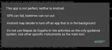
I'd loaded the app onto a Nexus 7 tablet and it gave me fair warning that the app is battery hungry. It also came up with one of the best map rubrics I've seen in a long time:

54406

It compares well with my all time favourite:

WARNING: Roads are shifted, houses burn, are abandoned or rebuilt;
a round world distorts a flat map;
man’s memory is fallible;
expect not exactness.


Having said that I'm sure it will give you what you want.
 
Well that was interesting. I'm quite impressed with the way the IGN app worked. OK, I wasn't working on the Spanish map obviously but the app accurately recorded my track, saved it and when I opened it up in maps.me it was just what I expected.
I'd loaded the app onto a Nexus 7 tablet and it gave me fair warning that the app is battery hungry. It also came up with one of the best map rubrics I've seen in a long time:

View attachment 54406

It compares well with my all time favourite:

WARNING: Roads are shifted, houses burn, are abandoned or rebuilt;
a round world distorts a flat map;
man’s memory is fallible;
expect not exactness.


Having said that I'm sure it will give you what you want.

@Jeff Crawley
I spent a few hours last night trying to make the IGN map system work. It provides instructions of a sort, that is, definitions of the functions of the app. These are available in English, and the app chooses the language to use according to the language of the device. But the English is obviously a very primitive machine translation. At best, I found myself putting the words back into Spanish and trying to understand what the instructions might mean in context. At worst, it is simply gibberish in English. And there is not enough basic instruction for those of us who are not really competent in using apps. I suspect that, like most other people who design apps, they design for one another (and for that tec savy 5 year old that we oldies here refer our challenges to) and don't really consider the needs of the many people who would like to be able to use the app, if we knew how. Or could figure out how. In my own city, residents are currently trying to figure out how to adjust to the changes in a public parking app: nobody wants to pay a fine because the app now has a different way to set up a warning message when the parking which has been paid for runs out.
I definitely shouldn't be addressing my rant to you, since you have been kind enough to offer to help. I don't know how you could help, however, as we don't speak the same language. I just go on struggling. I don't understand how to do basic things with the IGN app. And I just go on trying to do things, usually unsuccessfully, and occasionally something I do works, but I don't know what I did. I must say, maps.me is much easier to use. The simple directions of the Dutch pilgrim group made it possible for me to add the camino routes to the maps, and that has proven very useful. Both apps share the weakness that updates are always going to be late. Word of mouth, passed on through this forum, is still how we tell one another that albergues have closed, a route been moved, or new services or accommodations are available.
I will go on trying, learning what I can and using what I learn. The camino has expanded my horizons in unexpected ways. And thanks to all those who try to assist us tec illiterate.
 
Last edited:
...and ship it to Santiago for storage. You pick it up once in Santiago. Service offered by Casa Ivar (we use DHL for transportation).
@Jeff Crawley
I spent a few hours last night trying to make the IGN map system work. It provides instructions of a sort, that is, definitions of the functions of the app. These are available in English, and the app chooses the language to use according to the language of the device. But the English is obviously a very primitive machine translation. At best, I found myself putting the words back into Spanish and trying to understand what the instructions might mean in context. At worst, it is simply gibberish in English. And there is not enough basic instruction for those of us who are not really competent in using apps. I suspect that, like most other people who design apps, they design for one another (and for that tec savy 5 year old that we oldies here refers our challenges to) and don't really consider the needs of the many people who would like to be able to use the app, if we knew how. Or could figure out how. In my own city, residents are currently trying to figure out how to adjust to the changes in a public parking app: nobody wants to pay a fine because the app now has a different way to set up a warning message when the parking which has been paid for runs out.
I definitely shouldn't be addressing my rant to you, since you have been kind enough to offer to help. I don't know how you could help, however, as we don't speak the same language. I just go on struggling. I don't understand how to do basic things with the IGN app. And I just go on trying to do things, usually unsuccessfully, and occasionally something I do works, but I don't know what I did. I must say, maps.me is much easier to use. The simple directions of the Dutch pilgrim group made it possible for me to add the camino routes to the maps, and that has proven very useful. Both apps share the weakness that update are always going to be late. Word of mouth, passed on through this forum, is still how we tell one another that albergues have closed, a route been moved, or new services or accommodations are available.
I will go on trying, learning what I can and using what I learn. The camino has expanded my horizons in unexpected ways. And thanks to all those who try to assist we tec illiterate.
54412

If you feel a (mainly pictoral) guide for novices would be helpful let me know - I have time on my hands!

And, by the way, I'm the guy who was so pleased with himself understanding Hawking's Brief History of Time and then I got to page 17 . . . . .😱
 
Really this is for @kirkie but you don't seem to be able to post attachments in Conversations so I'll hijack this topic (anybody can take a peak if they wish)

"See if the attached is what you're after. Once we've cracked the What you want we can go on to do the How you get it"

The manual in @thomas 1962 post above (#14) is very useful.
 

Attachments

A selection of Camino Jewellery
Really this is for @kirkie but you don't seem to be able to post attachments in Conversations so I'll hijack this topic (anybody can take a peak if they wish)

"See if the attached is what you're after. Once we've cracked the What you want we can go on to do the How you get it"

The manual in @thomas 1962 post above (#14) is very useful.
Thanks, Jeff. I can look later, Right now, a bit of cooking and a bit of translation... I really appreciate the time and trouble. Will report back as soon as I have had a chance to try it out.
 
View attachment 54412

If you feel a (mainly pictoral) guide for novices would be helpful let me know - I have time on my hands!

And, by the way, I'm the guy who was so pleased with himself understanding Hawking's Brief History of Time and then I got to page 17 . . . . .😱
I have read A brief history of time twice, the second time, just for pleasure. But I don't understand the math which underlies it, just the basic idea. By the way, it was a Canadian graduate student who had the duty of telling Stephen that his mathematics don't work.
 
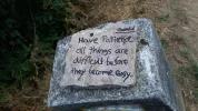
The one from Galicia (the round) and the one from Castilla & Leon. Individually numbered and made by the same people that make the ones you see on your walk.
A selection of Camino Jewellery
It's wonderful, how and where this thread has wandered 'off the map.'
Thank you for the fun meandering, everyone.:cool:

And thank you especially for picking this out and linking to it, Jeff:
Indeed by opening a kml file in Google earth you can pick out any specific route and give it a colour.
To use these files, or any other KML of GPX files in OSMand or any other app like Maps.me, this manual might help.
It answers a ton of my questions And I bet I'm not the only one. And the Dutch resource is fabulous. Wow - thanks for the link, Thomas!
 
Last edited:
Not bad at all -- there are MANY routes missing, though truth is I've never seen a properly complete one, though it's nice to see that my projected Way between Caceres and Fatima is in there, first time I've *ever* seen it mapped.

Strange too is the lengthy gap on the Provençal Way in the south of France, as exactly the same gap appears on my own phone App (but not the desktop PC version).

The Ways in the French and Spanish Languedoc and Catalonia are insufficiently detailed, several important variants of the Cami Catalan being pure and simple absent. The three routes out from Perpignan at least should have been detailed, as they're all fundamentally Spanish/Catalan Ways.

And the Way down from Andorra is AWOL too.

But blimey, even with all those imperfections, this will still be very useful indeed !! And it's still one of the best maps I've seen.

I do hope that more work on it is projected for the French Ways ...
 
Really this is for @kirkie but you don't seem to be able to post attachments in Conversations so I'll hijack this topic (anybody can take a peak if they wish)

"See if the attached is what you're after. Once we've cracked the What you want we can go on to do the How you get it"

The manual in @thomas 1962 post above (#14) is very useful.
For anybody who had a peek, I did what Jeff told me to do. I ended up with what he intended me to see on the screen. So, congrats to Jeff! Now, I will not promise to be able to do it a second time, but I will wipe what i got and try it again this afternoon. It is too windy for the bike, so why not hone up my tech map skills?
 
The one from Galicia (the round) and the one from Castilla & Leon. Individually numbered and made by the same people that make the ones you see on your walk.
As the IGN maps are only for Spain, as far as I know

IGN maps France Spain and I believe Portugal too (plus Andorra and that *one* hiking trail out of Monaco).

IGN is the French Institut Géographique National, so you shouldn't be surprised that it provides many French maps.
 
The maps app I'm using on this Camino is mapy.cz -- which appears to be perfectly cross-platform, as it exists as a website, a Windows App, Apple App, Chrome App, iPhone App, even a flipping Windows Phone version that I'm using myself !!

The desktop Windows PC version of it is particularly good.

I haven't the foggiest notion if this data source could be added to it ...
 
€2,-/day will present your project to thousands of visitors each day. All interested in the Camino de Santiago.
IGN maps France Spain and I believe Portugal too (plus Andorra and that *one* hiking trail out of Monaco).

IGN is the French Institut Géographique National, so you shouldn't be surprised that it provides many French maps.
Except the maps for Spain are from the Instituto Geográfico Nacional the national mapping body for . . . Spain 🇪🇸

(Sorry, couldn't resist ;))
 
The maps app I'm using on this Camino is mapy.cz -- which appears to be perfectly cross-platform, as it exists as a website, a Windows App, Apple App, Chrome App, iPhone App, even a flipping Windows Phone version that I'm using myself !!

The desktop Windows PC version of it is particularly good.

I haven't the foggiest notion if this data source could be added to it ...
Nice clean, user friendly app. Not unlike the Dutch TomTom platform. You can upload .gpx to it.
 
Made up my mind.. No walk today. Instead, having balanced the books, made the bread, cleaned the kitchen, made up the guest bed, I am going to have some soup and then - darran! attack Jeff's suggestions again. Let's see what ensues. Maybe I will win, maybe not. I will tell all. Jeff, by the way, you are very generous and affirmative
 
Train for your next Camino on California's Santa Catalina Island March 16-19
Made up my mind.. No walk today. Instead, having balanced the books, made the bread, cleaned the kitchen, made up the guest bed, I am going to have some soup and then - darran! attack Jeff's suggestions again. Let's see what ensues. Maybe I will win, maybe not. I will tell all. Jeff, by the way, you are very generous and affirmative
😊😊 What kind of bread? 🍞
 
😊😊 What kind of bread? 🍞
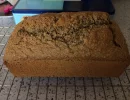
this kind of bread...


Kevin Dundon's Traditional Brown Bread

Kevin says: "Sometimes I add in some pine nuts, sesame, pumpkin, sunflower, fennel, and caraway seeds for a healthy crunchy finish. Diced dried apricots and sultanas add an unusual finish to the bread also."

Write a review​


Ingredients

  1. 12ozs/350g wholemeal flour
  2. 2ozs/50g plain flour
  3. 2oz/50g porridge oats
  4. Pinch salt
  5. 2 level teaspoon bread soda
  6. 2 large eggs
  7. 1 dessertspoon of sunflower oil
  8. 18flozs/500ml buttermilk.
Instructions

  1. Preheat the oven to 170C/325F/Gas Mark 3
  2. Put the flours, sieved bread soda, salt and porridge oats into a large mixing bowl and well them well.
  3. In a separate bowl beat the eggs together with the oil and add to the dry mixture.
  4. Next mix in the buttermilk and get the mix to a “sloppy” consistency.
  5. Pour into a 2lb loaf tin and smooth the top of the bread with a wet spoon.
  6. Sprinkle some seeds or porridge oats on top of the bread and bake in the oven for 1 hour.
  7. After the hour has elapsed remove the bread from the tin and return to the oven to bake for a further 20 minutes.
  8. Remove from the oven and allow the bread to cool down.
Notes

  1. 2 tablespoons treacle in the wet mix makes darker & sweeter bread.
  2. This bread stays fresh for about 4-5 days.
  3. It can be successfully frozen.
  4. The mixture can be spooned into muffin tins and baked (approx 25-30 minutes @ 180C)
 
Perfect memento/gift in a presentation box. Engraving available, 25 character max.
https://hiking.waymarkedtrails.org is also a good site to find trails and maps for your GPS or Google maps. It has all the Caminos and other trails small and big. From around the world. If you duble click on the trail you will get more information and can download the kml file.
 
I love this. If anyone wants to expand a file, this is the one to start with, add to and make it even better.

My skills and time do not allow but would it not be great to see the Via Francigena and all the, "now accepted," paths in Ireland added to this?
 
Very cool!
Just curious - What is the ring of blue dots near Logroño?
I thought the same... I clicked on some but was none the wiser :)

Those jumped out at me too. Was gonna make a wise crack about a pilgrim loopy on too much wine. Then I followed Jeff Crawley's "stack of coins" advice, and it appears to be Senda del Pastoreo / GR282

According one site, it is a "Multi-day route through the mountains of Alava...based on the ancestral routes of the shepherds...It is structured in 19 stages that cover 485 kms."

For those curious, more details here
 
Last edited:
€2,-/day will present your project to thousands of visitors each day. All interested in the Camino de Santiago.
Thank you for this outstanding map with all the routes.

There is just one route I am missing. It is a route with all the yellow arrows and the official blue plagues with the camino logo showing the way. It is the route form Caminha to Valenca on the Portuguese Camino. I did it in 2017 and found all the markers of an official route. It was one of the most beautiful routes of the Portuguese camino (except for the routes along the beaches). Is there a reason why this route is not on the map?

IMG_5077.webp
 
Really this is for @kirkie but you don't seem to be able to post attachments in Conversations so I'll hijack this topic (anybody can take a peak if they wish)

"See if the attached is what you're after. Once we've cracked the What you want we can go on to do the How you get it"

The manual in @thomas 1962 post above (#14) is very useful.
Good morning, sir! I had a resident teacher show me yesterday how to make OSMand and wikiloc talk to each other. I do not yet understand, but I do not need to. It works. That is good enough for me. At the moment. I need to get ready to pack and head out the door on Friday. Next week I will have time to re-read what you did for me, and now I can be fairly confident that it will make more sense this time around. I was so pleased today to switch my phone to flight mode, and still see the routes i had found yesterday!
Now, once more, thanks, Jeff, and I will report back as soon as I have something sensible to say. Ok, that could be a few years. I will report back before the end of next week!
 
...and ship it to Santiago for storage. You pick it up once in Santiago. Service offered by Casa Ivar (we use DHL for transportation).
Thank you for this outstanding map with all the routes.

There is just one route I am missing. It is a route with all the yellow arrows and the official blue plagues with the camino logo showing the way. It is the route form Caminha to Valenca on the Portuguese Camino. I did it in 2017 and found all the markers of an official route. It was one of the most beautiful routes of the Portuguese camino (except for the routes along the beaches). Is there a reason why this route is not on the map?

View attachment 54562
Please forgive me! I am sore with laughing. just one little letter can make all the difference.!
 
Good morning, sir! I had a resident teacher show me yesterday how to make OSMand and wikiloc talk to each other. I do not yet understand, but I do not need to. It works. That is good enough for me. At the moment. I need to get ready to pack and head out the door on Friday. Next week I will have time to re-read what you did for me, and now I can be fairly confident that it will make more sense this time around. I was so pleased today to switch my phone to flight mode, and still see the routes i had found yesterday!
Now, once more, thanks, Jeff, and I will report back as soon as I have something sensible to say. Ok, that could be a few years. I will report back before the end of next week!
Kind words indeed. You don't have to know how it works . . . so long as it does! It's a bit like not knowing why a bike doesn't topple over as long as you keep peddling.
Hope you have a wonderful time and remember - we're all here if you need us.

Blessings and Ultreia!
 
Ideal sleeping bag liner whether we want to add a thermal plus to our bag, or if we want to use it alone to sleep in shelters or hostels. Thanks to its mummy shape, it adapts perfectly to our body.

€46,-

❓How to ask a question

How to post a new question on the Camino Forum.

Most read last week in this forum

I saw a video with a rather harsh criticism of a small, municipal albergue on one of the less traveled caminos. They paid 9€. I thought: What does it cost a small municipality to renovate and keep...
On my last Camino (2023) I noticed that there were lots of tourists. It reminded me of a couple of quotes that I have read since my first Camino (2015) “A tourist demands, a pilgrim is grateful”...
"A complete guide to the world's greatest pilgrimage"[sic] by Sarah Baxter. In a British newspaper, The Telegraph. A right wing daily that does print interesting articles and essays...
I've been trying to figure out how to use the Gronze app and as a first step I need to translate into English - I searched topics on the Forum, thought I found what I was looking for, and Yay! I...
Day 42 Week 6 460km walked (give or take) Today I had a revelation, an epiphany and a Divine Intervention... all in one day. Today the exreme pain in my soul is dissipating some... healed by the...
I was hoping to do a walk over ninety days so I researched a long stay visa. This walk would have gone through four countries but the majority of the time would have been in France. So I applied...

Featured threads

❓How to ask a question

How to post a new question on the Camino Forum.

Featured threads

Forum Rules

Forum Rules

Camino Updates on YouTube

Camino Conversations

Most downloaded Resources

This site is run by Ivar at

in Santiago de Compostela.
This site participates in the Amazon Affiliate program, designed to provide a means for Ivar to earn fees by linking to Amazon
Official Camino Passport (Credential) | 2024 Camino Guides
Back
Back
Top